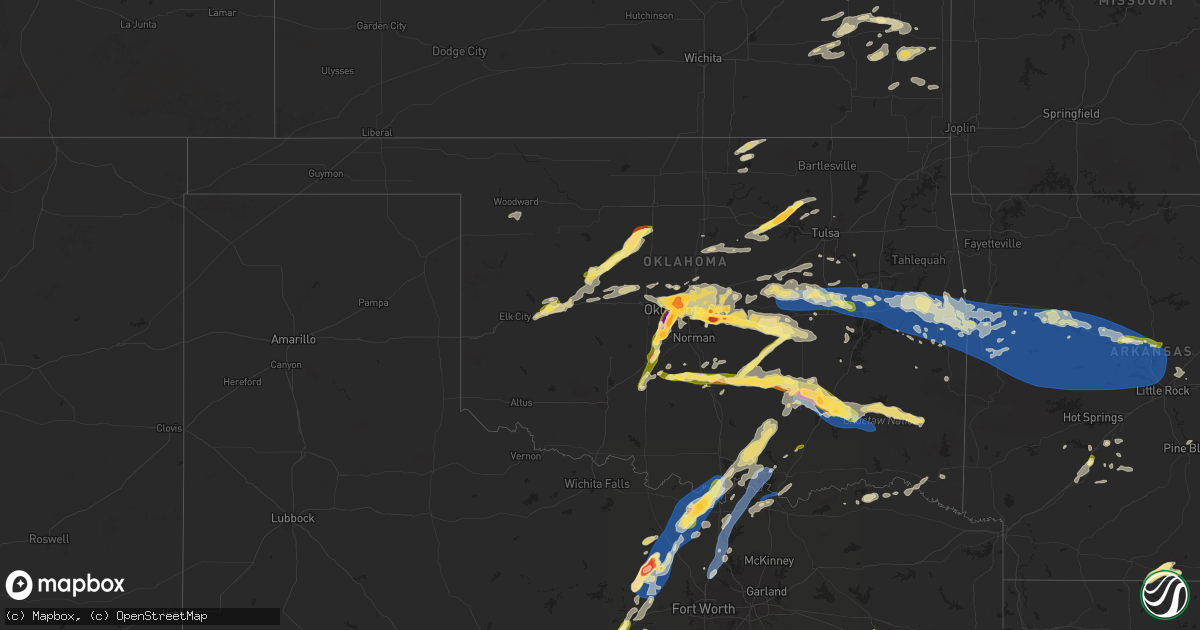
Hail Map in Oklahoma on May 17, 2025
Get this storm
May 17 map
$229
one time, instant access
Download today. No call, no setup
Keep the $229
Bought the map and want the full workflow? Apply the entire $229 to a subscription within 7 days. None of it is wasted.
Every map, not just this one
This buys you this map. Subscription and you get every map we run, in the markets you choose from a few cities to whole states to nationwide. Plus real-time alerts the moment a storm fires.
Contact data
Name, contact info, occupancy, even credit band for addresses in the footprint. You go from where it hit to who to call.
Become the source they trust
Unlimited branding weather history reports on demand. You already have the documented answer ready for the property owner, and you are the one who showed up with it.
Property data and RoofTrace estimates
Pull up any address you have got, its value and the exact code rules for that jurisdiction, straight from One Click Code. Then RoofTrace estimates the squares, pitch, and roof value, priced the way you price.
Storm reports in Oklahoma
Oklahoma
| Date | Description |
|---|---|
| 05/17/20256:50 PM CDT | Report from mping: quarter |
| 05/17/20256:44 PM CDT | Report from mping: quarter |
| 05/17/20255:12 PM CDT | Report from mping: hen egg+ |
| 05/17/20255:11 PM CDT | Report from mping: half dollar |
| 05/17/20255:10 PM CDT | A local report indicates 1.00 inch wind near 5 ENE Tuttle |
| 05/17/20255:05 PM CDT | A local report indicates 1.25 inch wind near 4 SSW Bethany |
| 05/17/20255:05 PM CDT | A local report indicates 1.50 inch wind near 3 NNE Mustang |
| 05/17/20255:05 PM CDT | Report from mping: hen egg |
| 05/17/20255:05 PM CDT | Report from mping: ping pong ball |
| 05/17/20255:04 PM CDT | Report from mping: half dollar |
| 05/17/20255:04 PM CDT | A local report indicates 1.00 inch wind near 3 NNW Mustang |
| 05/17/20255:03 PM CDT | A local report indicates 2.75 inch wind near Mustang |
| 05/17/20255:02 PM CDT | Report from mping: hen egg+ |
| 05/17/20255:02 PM CDT | Report from mping: quarter |
| 05/17/20254:59 PM CDT | Report from mping: half dollar |
| 05/17/20254:56 PM CDT | Report from mping: golf ball |
| 05/17/20254:53 PM CDT | Report from mping: baseball |
| 05/17/20254:50 PM CDT | A local report indicates 1.75 inch wind near 3 ENE Tuttle |
| 05/17/20254:49 PM CDT | Report from mping: half dollar |
| 05/17/20254:48 PM CDT | A local report indicates 1.25 inch wind near 3 SE Bradley |
| 05/17/20254:46 PM CDT | Report from mping: quarter |
| 05/17/20254:45 PM CDT | Report from mping: quarter |
| 05/17/20254:26 PM CDT | A local report indicates 1.00 inch wind near Chickasha |
| 05/17/20254:35 AM CDT | Delayed report of shingles off a roof approximately 8 miles east of spiro. Time estimated from radar. |
| 05/17/20253:55 AM CDT | Delayed report. Trees downed. Time estimated via radar. |
| 05/17/20253:39 AM CDT | A local report indicates 58 MPH wind near 1 WNW Webbers Falls |
| 05/17/20253:22 AM CDT | 55 mph winds also reported. |
| 05/17/20253:03 AM CDT | Hwy 266 & 300 rd; time estimated by radar. |
| 05/17/20252:55 AM CDT | A local report indicates 60 MPH wind near 3 SW Morris |
| 05/17/20252:53 AM CDT | Time estimated by radar. |
| 05/17/20252:50 AM CDT | Multiple trees down on sharp rd between okmulgee and wilson rd intersection sw of town. Time estimated by radar. |
| 05/17/20251:35 AM CDT | Phone call report. |
| 05/17/20251:30 AM CDT | Report from mping: half dollar |
| 05/17/20251:30 AM CDT | Report from mping: quarter |
| 05/16/202511:08 PM CDT | Report from mping: golf ball |
| 05/16/202511:01 PM CDT | A local report indicates 1.75 inch wind near 1 W Cleveland |
| 05/16/202510:59 PM CDT | A local report indicates 1.50 inch wind near 1 W Cleveland |
| 05/16/202510:42 PM CDT | Report from mping: quarter |
| 05/16/202510:35 PM CDT | A local report indicates 2.25 inch wind near 1 SW Dale |
| 05/16/202510:22 PM CDT | Near i-40 and peebly road. |
| 05/16/202510:10 PM CDT | A local report indicates 1.00 inch wind near 5 S Nicoma Park |
| 05/16/20259:58 PM CDT | A local report indicates 1.00 inch wind near 1 NW Tinker Air Force B |
| 05/16/20259:54 PM CDT | A local report indicates 1.25 inch wind near 1 W Tinker Air Force Ba |
| 05/16/20259:54 PM CDT | A local report indicates 1.00 inch wind near 2 W Tinker Air Force Ba |
| 05/16/20259:52 PM CDT | A local report indicates 60 MPH wind near 6 SW Oklahoma City |
| 05/16/20259:51 PM CDT | A local report indicates 1.00 inch wind near 3 SW Tinker Air Force B |
| 05/16/20259:38 PM CDT | Corrects previous tstm wnd gst report from 6 sw oklahoma city. |
| 05/16/20259:33 PM CDT | A local report indicates 1.75 inch wind near 2 S Warr Acres |
| 05/16/20259:30 PM CDT | A local report indicates 1.25 inch wind near 3 S Bethany |
| 05/16/20257:57 PM CDT | A local report indicates 73 MPH wind near Wardville |
| 05/16/20257:57 PM CDT | A local report indicates 1.75 inch wind near Wardville |
| 05/16/20257:55 PM CDT | Report from mping: quarter |
All States Impacted by Hail Map on May 17, 2025
Cities Impacted by Hail Map on May 17, 2025
- Thorsby, AL
- Clanton, AL
- Franklin, GA
- Grantville, GA
- Newnan, GA
- Gouverneur, NY
- Moreland, GA
- Senoia, GA
- Sharpsburg, GA
- Laurens, SC
- Luthersville, GA
- Massena, NY
- Norfolk, NY
- Brasher Falls, NY
- Zebulon, GA
- Williamson, GA
- Griffin, GA
- Barnesville, GA
- Forsyth, GA
- Norwood, NY
- Milner, GA
- Bombay, NY
- Fort Covington, NY
- Holland Patent, NY
- Rome, NY
- Remsen, NY
- Rochester, NY
- Pittsford, NY
- Scottsville, NY
- Caledonia, NY
- Rush, NY
- West Henrietta, NY
- Cold Brook, NY
- Duanesburg, NY
- Schenectady, NY
- Parish, NY
- Pulaski, NY
- Altmar, NY
- Ballston Lake, NY
- Burnt Hills, NY
- Mechanicville, NY
- Williamstown, NY
- Stittville, NY
- Ballston Spa, NY
- Round Lake, NY
- Redford, NY
- Saranac, NY
- Schuyler Falls, NY
- Saratoga Springs, NY
- Edwards, MS
- Vicksburg, MS
- Bolton, MS
- Charlotte, VT
- North Ferrisburgh, VT
- Ferrisburgh, VT
- Shelburne, VT
- Bristol, VT
- Hinesburg, VT
- New Haven, VT
- Clinton, MS
- Raymond, MS
- Jackson, MS
- South Burlington, VT
- Westport, NY
- Essex, NY
- Vergennes, VT
- Williston, VT
- Essex Junction, VT
- Cadyville, NY
- Morrisonville, NY
- Peru, NY
- Richmond, VT
- Huntington, VT
- Byram, MS
- Thendara, NY
- Eagle Bay, NY
- Jericho, VT
- Plattsburgh, NY
- Schroon Lake, NY
- Willsboro, NY
- Adirondack, NY
- Starksboro, VT
- Colchester, VT
- Lohn, TX
- Brady, TX
- Pottersville, NY
- Brant Lake, NY
- Middlebury, VT
- Rochelle, TX
- Mason, TX
- Stowe, VT
- Mullin, TX
- Goldthwaite, TX
- Morrisville, VT
- Hyde Park, VT
- Rockwood, TX
- Santa Anna, TX
- Brookesmith, TX
- Priddy, TX
- Richland Springs, TX
- Northville, NY
- Comanche, TX
- San Saba, TX
- Utica, NY
- Marcy, NY
- Whitesboro, NY
- Flora, MS
- Junction, TX
- Poland, NY
- Barneveld, NY
- Frankfort, NY
- Underhill, VT
- Cambridge, VT
- Waterbury, VT
- Porter Corners, NY
- Art, TX
- Waterbury Center, VT
- Valley Spring, TX
- Pontotoc, TX
- Greenfield Center, NY
- Newport, NY
- Corinth, NY
- Gustine, TX
- Lake Luzerne, NY
- Gansevoort, NY
- Wolcott, VT
- Hamilton, TX
- Richland, MS
- Dublin, TX
- Spearsville, LA
- Evant, TX
- Star, TX
- Marlow, OK
- Rush Springs, OK
- Pottsville, TX
- Carlton, TX
- Voca, TX
- Fredonia, TX
- Madill, OK
- Kingston, OK
- Ninnekah, OK
- Strong, AR
- Huttig, AR
- Fort Edward, NY
- Raleigh, MS
- Stephenville, TX
- Schuylerville, NY
- Chickasha, OK
- Bradley, OK
- Amber, OK
- Pioneer, LA
- Oak Grove, LA
- Lampasas, TX
- Greenwich, NY
- Tuttle, OK
- Lindsay, OK
- Gordon, TX
- Santo, TX
- Pine Hill, AL
- Alex, OK
- Bluff Dale, TX
- Purmela, TX
- Mingus, TX
- Hamburg, AR
- Jonesboro, TX
- Mustang, OK
- Oklahoma City, OK
- Newcastle, OK
- Yukon, OK
- Wheatland, OK
- Blanchard, OK
- Tolar, TX
- Lake Providence, LA
- Lipan, TX
- Woodstock, VT
- Stillwater, NY
- Iredell, TX
- Gatesville, TX
- Bethany, OK
- Maysville, OK
- Paoli, OK
- Wayne, OK
- Pauls Valley, OK
- Morgan, TX
- Meridian, TX
- Quechee, VT
- Hartland, VT
- White River Junction, VT
- Millsap, TX
- Richmond, MA
- Pittsfield, MA
- West Lebanon, NH
- North Hartland, VT
- Taftsville, VT
- Portland, AR
- Walnut Springs, TX
- Mineral Wells, TX
- Schaghticoke, NY
- Perrin, TX
- Graford, TX
- Weatherford, TX
- Whitt, TX
- Byars, OK
- Purcell, OK
- Camden, AL
- Transylvania, LA
- Thetford Center, VT
- South Strafford, VT
- Enfield, NH
- Wilder, VT
- Lebanon, NH
- Hanover, NH
- Hinsdale, MA
- Becket, MA
- Lenox, MA
- Dalton, MA
- Plainfield, NH
- Mayersville, MS
- Rolling Fork, MS
- Poolville, TX
- Jacksboro, TX
- Bridgeport, TX
- Canaan, NH
- Stratford, OK
- Vredenburgh, AL
- Etna, NH
- Lexington, OK
- Grantham, NH
- Pine Apple, AL
- Blum, TX
- Springtown, TX
- Paradise, TX
- Whitney, TX
- Caddo, OK
- Caney, OK
- Chico, TX
- Decatur, TX
- Bonita, LA
- Jones, LA
- Beatrice, AL
- Parkdale, AR
- Hillsboro, TX
- Itasca, TX
- Wanette, OK
- Kopperl, TX
- Abbott, TX
- Aquilla, TX
- Clifton, TX
- Fort Worth, TX
- Keller, TX
- Ada, OK
- Cherokee, TX
- Alvord, TX
- West, TX
- Forestburg, TX
- Roanoke, TX
- Argyle, TX
- Justin, TX
- Georgiana, AL
- Bowie, TX
- Fort Rucker, AL
- Valley Park, MS
- Sunset, TX
- Evergreen, AL
- Muenster, TX
- Saint Jo, TX
- Asher, OK
- Konawa, OK
- Denton, TX
- Ponder, TX
- Sanger, TX
- Aubrey, TX
- Valley View, TX
- Rosston, TX
- Gainesville, TX
- Montague, TX
- Era, TX
- Lindsay, TX
- Nocona, TX
- Thackerville, OK
- Burneyville, OK
- Leon, OK
- Wilmot, AR
- Newton, AL
- Ozark, AL
- Marietta, OK
- Bennett, CO
- Allen, OK
- Stonewall, OK
- Coalgate, OK
- Centrahoma, OK
- Calvin, OK
- Strasburg, CO
- Sasakwa, OK
- Whitesboro, TX
- Stuart, OK
- Collinsville, TX
- Sadler, TX
- Gordonville, TX
- Pottsboro, TX
- Mead, OK
- Wardville, OK
- Sherman, TX
- Denison, TX
- Ardmore, OK
- Lebanon, OK
- Tupelo, OK
- Lindale, TX
- Kiowa, OK
- Atoka, OK
- Pittsburg, OK
- Severy, KS
- Mill Creek, OK
- Mannsville, OK
- Tishomingo, OK
- Calera, OK
- Colbert, OK
- Hendrix, OK
- Kenefic, OK
- Athens, TX
- Stringtown, OK
- Daisy, OK
- Milburn, OK
- Weare, NH
- Okolona, AR
- Gurdon, AR
- Wapanucka, OK
- Sumner, TX
- Antlers, OK
- Yates Center, KS
- Arkadelphia, AR
- Powderly, TX
- Paris, TX
- Clayton, OK
- Sharon, OK
- Wynnewood, OK
- Blossom, TX
- Humboldt, KS
- Woodward, OK
- Detroit, TX
- Coy, AL
- Lafayette, AL
- Maud, OK
- Parker, KS
- Centerville, KS
- Bagwell, TX
- Savonburg, KS
- Elsmore, KS
- Snow, OK
- Nashoba, OK
- Mcalester, OK
- Garvin, OK
- Clarksville, TX
- Red Oak, OK
- Erie, KS
- Moran, KS
- Idabel, OK
- Heavener, OK
- Mccurtain, OK
- Garnett, KS
- Uniontown, KS
- Stark, KS
- Wewoka, OK
- Hepler, KS
- Amity, AR
- Sparkman, AR
- Seiling, OK
- Edmond, OK
- Holdenville, OK
- Neosho Falls, KS
- Guthrie, OK
- Virgil, KS
- Gridley, KS
- Westphalia, KS
- Redfield, KS
- Hartford, KS
- Burlington, KS
- Broken Bow, OK
- Le Roy, KS
- Hodgen, OK
- Fort Scott, KS
- Seminole, OK
- Wetumka, OK
- Choctaw, OK
- Newalla, OK
- Booneville, AR
- Arcadia, OK
- Bethel, OK
- Jones, OK
- Parsons, KS
- Galesburg, KS
- Honobia, OK
- Mansfield, AR
- Toronto, KS
- Luther, OK
- Iola, KS
- Colony, KS
- Saint Paul, KS
- Spencer, OK
- Mcloud, OK
- Shawnee, OK
- La Harpe, KS
- Fall River, KS
- Donaldson, AR
- Brackettville, TX
- Bismarck, AR
- Harrah, OK
- Clinton, OK
- Yale, OK
- Maramec, OK
- Malvern, AR
- Kincaid, KS
- Pawnee, OK
- Stillwater, OK
- Jennings, OK
- Glencoe, OK
- Girard, KS
- Meeker, OK
- McCune, KS
- Watonga, OK
- Thomas, OK
- Foss, OK
- Arapaho, OK
- Earlsboro, OK
- Sheldon, MO
- Cleveland, OK
- Weatherford, OK
- Geary, OK
- Fredonia, KS
- Bronson, KS
- Pittsburg, KS
- Osage, OK
- Hominy, OK
- Newkirk, OK
- Canute, OK
- Corn, OK
- Piqua, KS
- Chanute, KS
- Skiatook, OK
- Barnsdall, OK
- Hitchcock, OK
- Kingfisher, OK
- Loyal, OK
- Hennessey, OK
- Ponca City, OK
- Kaw City, OK
- Okeene, OK
- Waukomis, OK
- Pine Bluff, AR
- Grady, AR
- Carthage, AR
- Shidler, OK
- Leola, AR
- Ames, OK
- Bison, OK
- Calumet, OK
- Laredo, TX
- Walnut, KS
- Coyle, OK
- Burbank, OK
- Orlando, OK
- Mulhall, OK
- White Hall, AR
- Hydro, OK
- Perkins, OK
- Yorktown, AR
- Gould, AR
- Okarche, OK
- Moundville, MO
- Stuttgart, AR
- Milo, MO
- Ripley, OK
- Cushing, OK
- El Dorado Springs, MO
- El Reno, OK
- Gillett, AR
- Piedmont, OK
- Jerico Springs, MO
- Snow Lake, AR
- Glenpool, OK
- Bixby, OK
- Stroud, OK
- Wellston, OK
- Mounds, OK
- Duncan, MS
- Kiefer, OK
- Gunnison, MS
- Merigold, MS
- Mound Bayou, MS
- Rosedale, MS
- Chandler, OK
- Norman, OK
- Broken Arrow, OK
- Coweta, OK
- Sparks, OK
- Bristow, OK
- Kellyville, OK
- Depew, OK
- Doddsville, MS
- Shaw, MS
- Beggs, OK
- Sapulpa, OK
- Cleveland, MS
- Boyle, MS
- Prague, OK
- Paden, OK
- Ruleville, MS
- Minter City, MS
- Castle, OK
- Drew, MS
- Okemah, OK
- Schlater, MS
- Indianola, MS
- Sunflower, MS
- Okmulgee, OK
- Boley, OK
- Henryetta, OK
- Greenwood, MS
- Philipp, MS
- Council Hill, OK
- Carrollton, MS
- Moorhead, MS
- Morris, OK
- Boynton, OK
- Sidon, MS
- Weleetka, OK
- Muskogee, OK
- Coila, MS
- Oktaha, OK
- Checotah, OK
- Warner, OK
- Gore, OK
- Webbers Falls, OK
- Winona, MS
- McCarley, MS
- Dustin, OK
- Vian, OK
- Stigler, OK
- Porum, OK
- Eufaula, OK
- Hanna, OK
- Uniontown, AR
- Sallisaw, OK
- Gans, OK
- Indianola, OK
- Muldrow, OK
- Keota, OK
- Bokoshe, OK
- Spiro, OK
- Shady Point, OK
- Roland, OK
- Pocola, OK
- Alma, AR
- Van Buren, AR
- Fort Smith, AR
- Poteau, OK
- Natural Dam, AR
- Arkoma, OK
- Greenwood, AR
- Haskell, OK
- Starkville, MS
- Lavaca, AR
- Charleston, AR
- West Point, MS
- Magazine, AR
- Huntington, AR
- Whitefield, OK
- Barling, AR
- Aberdeen, MS
- Ozark, AR
- Paris, AR
- Branch, AR
- Cecil, AR
- Columbus, MS
- Ethelsville, AL
- Brookwood, AL
- Scranton, AR
- Hartman, AR
- Coal Hill, AR
- Lamar, AR
- New Blaine, AR
- Clarksville, AR
- Prue, OK
- McCalla, AL
- Vance, AL
- Reform, AL
- Millport, AL
- Knoxville, AR
- London, AR
- Delaware, AR
- Atkins, AR
- Russellville, AR
- Pottsville, AR
- Morrilton, AR
- Coker, AL
- Northport, AL
- Buhl, AL
- Dover, AR
- Bessemer, AL
- Elrod, AL
- Sperry, OK
- Gordo, AL
- Birmingham, AL
- Alabaster, AL
- Tuscaloosa, AL
- Calera, AL
- Plumerville, AR
- Hattieville, AR
- Tulsa, OK
- Helena, AL
- Pelham, AL
- Chelsea, AL
- Wilsonville, AL
- Columbiana, AL
- Greenbrier, AR
- Sylacauga, AL
- Shelby, AL
- Mount Olive, AL
- Goodwater, AL
- Weogufka, AL
- Adger, AL
- Conway, AR
- Sterrett, AL
- Owasso, OK
- Subiaco, AR
- Blue Mountain, AR
- Havana, AR
- Waldron, AR
- Ratcliff, AR
- Altus, AR
- Belleville, AR
- Dardanelle, AR
- Hector, AR
- Danville, AR
- Perryville, AR
- Briggsville, AR
- Harvey, AR
- Bluffton, AR
- Gravelly, AR
- Ola, AR
- Casa, AR
- Plainview, AR
- Rover, AR
- Springfield, AR
- Solgohachia, AR
- Adona, AR
- Vilonia, AR
- Jerusalem, AR
- Mayflower, AR
- Perry, AR
- Bigelow, AR
- Houston, AR
- Wooster, AR
- Maumelle, AR
- Roland, AR
- Paron, AR
- North Little Rock, AR
- Little Rock, AR
- Benton, AR
- Hot Springs Village, AR
- Alexander, AR
- Dolomite, AL
- Echola, AL
- West Blocton, AL
- Woodstock, AL
- Cottondale, AL
- Pleasant Grove, AL
- Fairfield, AL
- Brierfield, AL
- Montevallo, AL
- Harpersville, AL
- Childersburg, AL
- Vincent, AL
- Gardendale, AL
- Jacksonville, AR
- Sherwood, AR
- Vandiver, AL
- Leeds, AL
- Chester, AR
- Dyer, AR
- Stilwell, OK
- Mountainburg, AR
- Mulberry, AR
- Rudy, AR
- Cedarville, AR
- Hackett, AR
- Cameron, OK
- Bunch, OK
- Braggs, OK
- Midland, AR
- Hartford, AR
- Jessieville, AR
- Little Rock Air Force Base, AR
- Cabot, AR
- Ragland, AL
- Ohatchee, AL
- Ashland, AL
- Talladega, AL
- Alpine, AL
- Cropwell, AL


