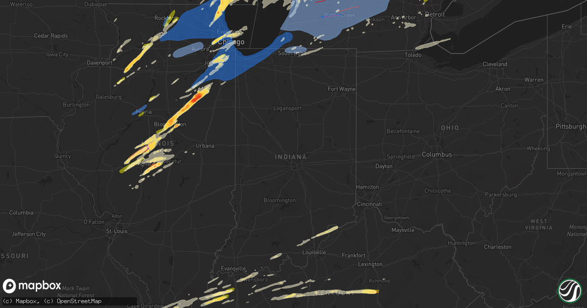
Hail Map in Indiana on May 15, 2025
Get this storm
May 15 map
$229
one time, instant access
Download today. No call, no setup
Keep the $229
Bought the map and want the full workflow? Apply the entire $229 to a subscription within 7 days. None of it is wasted.
Every map, not just this one
This buys you this map. Subscription and you get every map we run, in the markets you choose from a few cities to whole states to nationwide. Plus real-time alerts the moment a storm fires.
Contact data
Name, contact info, occupancy, even credit band for addresses in the footprint. You go from where it hit to who to call.
Become the source they trust
Unlimited branding weather history reports on demand. You already have the documented answer ready for the property owner, and you are the one who showed up with it.
Property data and RoofTrace estimates
Pull up any address you have got, its value and the exact code rules for that jurisdiction, straight from One Click Code. Then RoofTrace estimates the squares, pitch, and roof value, priced the way you price.
Storm reports in Indiana
Indiana
| Date | Description |
|---|---|
| 05/15/20256:30 AM CDT | Public emailed ops account with report accompanied by picture verifying quarter size hail. |
| 05/14/202510:55 PM CDT | Awos station kekm elkhart municipa. |
| 05/14/20259:05 PM CDT | Trees down. One reportedly on a mobile home. Time estimated by radar. |
| 05/14/20259:05 PM CDT | Delayed report of large tree downed on mobile home. Time estimated from radar. |
| 05/14/20259:04 PM CDT | Received photos of tree limbs down. Time estimated by radar. |
| 05/14/20258:59 PM CDT | Private weather station kinwheel1 reported 61 mph gust near wheeler. |
| 05/14/20258:50 PM CDT | Photo shared to social media shows possible damage to a shed on the north side of crown point. Time estimated by radar. |
| 05/14/20258:46 PM CDT | Large trees down at bailly elementary school. Time estimated by radar. |
| 05/14/20258:43 PM CDT | Photo shared to social media shows large branches broken in portage. Time estimated by radar. |
| 05/14/20258:42 PM CDT | Roads have been closed due to trees being down. Power outages across the city resulting in heavy traffic due to street lights being out. Stores are closed. Time estimat |
| 05/14/20258:40 PM CDT | Photos shared showing several shingles and other small portions of roofing material peeled off of house. |
| 05/14/20258:36 PM CDT | Trees down and power outages in gary around 71st avenue. Time estimated by radar. |
| 05/14/20258:35 PM CDT | Private weather station reported 66 mph gust near cedar lake. |
| 05/14/20258:33 PM CDT | 4-5 foot maple tree uprooted at north main street and franciscan drive. |
| 05/14/20258:33 PM CDT | Public email photos of a snapped tree in merrillville. Time estimated by radar. |
All States Impacted by Hail Map on May 15, 2025
Cities Impacted by Hail Map on May 15, 2025
- Broken Bow, OK
- Silver Lake, MN
- Lester Prairie, MN
- Glencoe, MN
- Watson, OK
- Cove, AR
- Wickes, AR
- Lake Crystal, MN
- Vandervoort, AR
- Mena, AR
- Elk River, MN
- Big Lake, MN
- Zimmerman, MN
- Princeton, MN
- Anoka, MN
- Saint Francis, MN
- Cambridge, MN
- Isanti, MN
- Stanchfield, MN
- Dalbo, MN
- Ogilvie, MN
- Braham, MN
- Mora, MN
- Grasston, MN
- Brook Park, MN
- Howe, OK
- Poteau, OK
- Cleveland, MN
- Elysian, MN
- Hackett, AR
- Heavener, OK
- Midland, AR
- Mansfield, AR
- Huntington, AR
- Hartford, AR
- Magazine, AR
- Paris, AR
- Subiaco, AR
- Brockwell, AR
- Delaware, AR
- London, AR
- Knoxville, AR
- Hagarville, AR
- Deer, AR
- New Blaine, AR
- Russellville, AR
- Dover, AR
- Witts Springs, AR
- Marshall, AR
- Wiseman, AR
- Horseshoe Bend, AR
- Ash Flat, AR
- Violet Hill, AR
- Lamar, AR
- Scranton, AR
- Mount Judea, AR
- Franklin, AR
- Pelsor, AR
- Cherokee Village, AR
- Hardy, AR
- Sage, AR
- Evening Shade, AR
- Jerusalem, AR
- Hector, AR
- Scotland, AR
- Clinton, AR
- Leslie, AR
- Ravenden Springs, AR
- Ravenden, AR
- Harriet, AR
- Big Flat, AR
- Timbo, AR
- Onia, AR
- Dennard, AR
- Pocahontas, AR
- Williford, AR
- Oronoco, MN
- Rochester, MN
- Zumbro Falls, MN
- Mazeppa, MN
- Maynard, AR
- Long Lake, MN
- Hamel, MN
- Doniphan, MO
- Byron, MN
- Fox, AR
- Shirley, AR
- New London, MN
- Belgrade, MN
- Mountain View, AR
- Melbourne, AR
- Fifty Six, AR
- Warm Springs, AR
- Cannon Falls, MN
- Elgin, MN
- Imboden, AR
- Pollocksville, NC
- Pine Island, MN
- Marcella, AR
- Batesville, AR
- Edgemont, AR
- South Saint Paul, MN
- Inver Grove Heights, MN
- Locust Grove, AR
- Welch, MN
- Minneapolis, MN
- Mount Pleasant, AR
- Guion, AR
- Millville, MN
- Andover, MN
- Nelson, WI
- Cedar, MN
- Bethel, MN
- New Bern, NC
- Paynesville, MN
- Melrose, MN
- Houston, MN
- Wabasha, MN
- Stillwater, MN
- Onamia, MN
- Cottage Grove, MN
- Saint Paul, MN
- Winona, MN
- Trempealeau, WI
- Galesville, WI
- Arcadia, WI
- Fountain City, WI
- Dodge, WI
- Durand, WI
- Freeport, MN
- Selma, NC
- Kenly, NC
- Alma, WI
- Lake City, MN
- Wyoming, MN
- Pepin, WI
- Kellogg, MN
- Stockholm, WI
- Dakota, MN
- Albany, MN
- Lake Elmo, MN
- Prescott, WI
- River Falls, WI
- Hastings, MN
- Arkansaw, WI
- Plum City, WI
- Avoca, WI
- Highland, WI
- Eau Galle, WI
- Menomonie, WI
- Ettrick, WI
- Independence, WI
- Blair, WI
- Bock, MN
- Milaca, MN
- Isle, MN
- Spring Green, WI
- Lone Rock, WI
- Lansing, IA
- Waukon, IA
- Pine City, MN
- Hudson, WI
- Roberts, WI
- New Richmond, WI
- Reads Landing, MN
- Elmwood, WI
- Hillpoint, WI
- Plain, WI
- Cazenovia, WI
- La Valle, WI
- Reedsburg, WI
- Deer Park, WI
- Sauk City, WI
- Amery, WI
- Star Prairie, WI
- Dodgeville, WI
- McGrath, MN
- Richland Center, WI
- Mondovi, WI
- Cochrane, WI
- New Albin, IA
- Aitkin, MN
- Bee Branch, AR
- Holmen, WI
- Eleva, WI
- Eau Claire, WI
- Whitehall, WI
- Wonewoc, WI
- North Freedom, WI
- Loganville, WI
- Rock Springs, WI
- Dalton, MN
- Ashby, MN
- Fergus Falls, MN
- Underwood, MN
- Battle Lake, MN
- Erhard, MN
- Pelican Rapids, MN
- Dent, MN
- Evansville, MN
- Brooklyn, WI
- Oregon, WI
- Mazomanie, WI
- Bemidji, MN
- Quitman, AR
- Heber Springs, AR
- Damascus, AR
- Elk Mound, WI
- Pikeville, NC
- Fremont, NC
- Dresser, WI
- Osceola, WI
- Hinckley, MN
- Eitzen, MN
- Balsam Lake, WI
- Saint Croix Falls, WI
- Hillsboro, WI
- Viola, WI
- Lucama, NC
- Belleville, WI
- Monticello, WI
- Albany, WI
- Mauston, WI
- Verona, WI
- Madison, WI
- Ferrum, VA
- Rocky Mount, VA
- Henry, VA
- Stoughton, WI
- Mcfarland, WI
- Milltown, WI
- Centuria, WI
- Fall Creek, WI
- Friendship, WI
- Mcgregor, MN
- Floral, AR
- Lowland, NC
- Hobucken, NC
- Turtle Lake, WI
- Manns Harbor, NC
- Prairie Du Sac, WI
- New Lisbon, WI
- Adams, WI
- Strum, WI
- Altoona, WI
- Wilburn, AR
- Tumbling Shoals, AR
- Drasco, AR
- Lime Ridge, WI
- Sulphur Rock, AR
- Sparta, WI
- Rockland, WI
- Cushing, WI
- Viroqua, WI
- Chaseburg, WI
- Baraboo, WI
- Charlotte, AR
- Hixton, WI
- Alma Center, WI
- Taylor, WI
- Black River Falls, WI
- Merrimac, WI
- Clayton, WI
- Clear Lake, WI
- Ontario, WI
- Wheeler, WI
- Ridgeland, WI
- Kendall, WI
- La Farge, WI
- Rose Bud, AR
- Manteo, NC
- Nags Head, NC
- Colfax, WI
- Cottage Grove, WI
- Chippewa Falls, WI
- Cross Plains, WI
- Middleton, WI
- Waunakee, WI
- Dane, WI
- Deforest, WI
- Lodi, WI
- Barron, WI
- Dallas, WI
- Elroy, WI
- Rocky Mount, NC
- Oil Trough, AR
- Wilton, WI
- Finlayson, MN
- Comstock, WI
- Fairchild, WI
- Humbird, WI
- Merrillan, WI
- Necedah, WI
- Arkdale, WI
- Cashton, WI
- Warrens, WI
- Pleasant Plains, AR
- Rosie, AR
- Tomah, WI
- Camp Douglas, WI
- Windsor, WI
- Cord, AR
- Tuckerman, AR
- Newark, AR
- Bradford, AR
- Thida, AR
- Magness, AR
- Newport, AR
- Pangburn, AR
- Westby, WI
- Havelock, NC
- Almena, WI
- Bloomer, WI
- Poynette, WI
- Osseo, WI
- Sun Prairie, WI
- Cameron, WI
- Chetek, WI
- Rice Lake, WI
- Willard, WI
- Arlington, WI
- Jim Falls, WI
- Hayward, WI
- Davis Junction, IL
- Stillman Valley, IL
- Valliant, OK
- Tarboro, NC
- Macclesfield, NC
- Lyndon Station, WI
- Wisconsin Dells, WI
- Portage, WI
- Norwalk, WI
- Lewiston Woodville, NC
- Nekoosa, WI
- Barneveld, WI
- Neillsville, WI
- Pardeeville, WI
- Wanchese, NC
- Swifton, AR
- Wright City, OK
- Cadott, WI
- Cornell, WI
- Rio, WI
- Savanna, IL
- Cash, AR
- Endeavor, WI
- Montello, WI
- Greenwood, WI
- Chili, WI
- Marshfield, WI
- Granton, WI
- Eagle, WI
- Palmyra, WI
- East Troy, WI
- Pittsville, WI
- Elizabeth, IL
- Hanover, IL
- Windsor, NC
- Elkhorn, WI
- Whitewater, WI
- Deerfield, WI
- Columbia, NC
- Rockford, IL
- Monroe Center, IL
- Oneida, IL
- Columbus, WI
- Albany, IL
- Minong, WI
- Marshall, WI
- Hancock, WI
- Wyocena, WI
- Cambria, WI
- Altona, IL
- Woodhull, IL
- Galva, IL
- Bishop Hill, IL
- Cambridge, IL
- Kewanee, IL
- Backus, MN
- Waterloo, WI
- Bethel, NC
- Greenville, NC
- Harrisonburg, VA
- Erie, IL
- Fenton, IL
- Holcombe, WI
- Fulton, IL
- Morrison, IL
- Wisconsin Rapids, WI
- Oak City, NC
- Cordova, IL
- Aulander, NC
- Robersonville, NC
- Stumpy Point, NC
- Weiner, AR
- Hillsdale, IL
- Hobgood, NC
- Loyal, WI
- Owen, WI
- Hamilton, NC
- Markesan, WI
- Dalton, WI
- Cherry Valley, IL
- Poplar Grove, IL
- Belvidere, IL
- Loves Park, IL
- Caledonia, IL
- Fall River, WI
- Doylestown, WI
- Bancroft, WI
- Plainfield, WI
- Randolph, WI
- Atkinson, IL
- Annawan, IL
- Friesland, WI
- Prophetstown, IL
- Tampico, IL
- Mineral, IL
- Dousman, WI
- Oconomowoc, WI
- Williamston, NC
- Waukesha, WI
- Wales, WI
- Stokes, NC
- Delafield, WI
- Hartland, WI
- Elkton, VA
- Colby, WI
- Dayton, VA
- Broadway, VA
- Rudolph, WI
- Reeseville, WI
- Capron, IL
- Beaver Dam, WI
- Port Edwards, WI
- Nashotah, WI
- Pewaukee, WI
- Hartford, WI
- Colgate, WI
- Lowell, WI
- Watertown, WI
- Juneau, WI
- Briggsville, WI
- Unity, WI
- Spencer, WI
- Stratford, WI
- Wahkon, MN
- Sheffield, IL
- Port Republic, VA
- McGaheysville, VA
- Penn Laird, VA
- Arpin, WI
- Vesper, WI
- Abbotsford, WI
- Dorchester, WI
- Athens, WI
- Edgar, WI
- Babcock, WI
- Curtiss, WI
- Stevens Point, WI
- Sussex, WI
- Oxford, WI
- Deer Grove, IL
- Harmon, IL
- Rock Falls, IL
- Dixon, IL
- Keezletown, VA
- Monroe, WI
- Hubertus, WI
- North Prairie, WI
- Washington, NC
- Richfield, WI
- Slinger, WI
- Colerain, NC
- Burnett, WI
- Junction City, WI
- Creswell, NC
- Kingston, WI
- Merry Hill, NC
- Ahoskie, NC
- Helenville, WI
- Lake Geneva, WI
- Edenton, NC
- Horicon, WI
- Sterling, IL
- Plover, WI
- Burlington, WI
- Mukwonago, WI
- Crozet, VA
- Free Union, VA
- Waterford, WI
- Big Bend, WI
- Allenton, WI
- West Bend, WI
- Kewaskum, WI
- Sullivan, WI
- Princeton, IL
- Ohio, IL
- Ixonia, WI
- Oregon, IL
- Franklin Grove, IL
- Alexander, IL
- Mayville, WI
- Lebanon, WI
- Iron Ridge, WI
- Theresa, WI
- Rubicon, WI
- Ashippun, WI
- Neosho, WI
- Mosinee, WI
- Neshkoro, WI
- Springfield, WI
- Ashton, IL
- Chana, IL
- Grottoes, VA
- Chocowinity, NC
- Lomira, WI
- Brownsville, WI
- Pleasant Plains, IL
- Petersburg, IL
- Tallula, IL
- Athens, IL
- Blounts Creek, NC
- Franklin, IL
- Jacksonville, IL
- New Berlin, IL
- Waverly, IL
- Springfield, IL
- Greenview, IL
- Campbellsport, WI
- Fond Du Lac, WI
- Eden, WI
- Dalzell, IL
- Lowpoint, IL
- Tremont, IL
- Morton, IL
- Lacon, IL
- Magnolia, IL
- Peru, IL
- Groveland, IL
- East Peoria, IL
- Washburn, IL
- Pekin, IL
- San Jose, IL
- Delavan, IL
- Spring Valley, IL
- Metamora, IL
- Washington, IL
- Mason City, IL
- McNabb, IL
- Mendota, IL
- Green Valley, IL
- Granville, IL
- Varna, IL
- New Holland, IL
- Middletown, IL
- Kirkland, IL
- Holcomb, IL
- Rochelle, IL
- Wautoma, WI
- Ashland, IL
- Schofield, WI
- Rothschild, WI
- Barrington, IL
- Lake Zurich, IL
- Palatine, IL
- Muskego, WI
- Coloma, WI
- Brandon, WI
- Ripon, WI
- Manlius, IL
- Walnut, IL
- Milwaukee, WI
- Greendale, WI
- La Moille, IL
- Oakfield, WI
- Hustisford, WI
- Ringle, WI
- Hanna City, IL
- Glasford, IL
- Mapleton, IL
- Peoria, IL
- Peoria Heights, IL
- Princeton, WI
- Elkhart, IL
- Green Lake, WI
- Cantrall, IL
- Sherman, IL
- Franksville, WI
- Clare, IL
- Malta, IL
- Esmond, IL
- Lindenwood, IL
- Kingston, IL
- Sycamore, IL
- Charlottesville, VA
- Garden Prairie, IL
- Gurnee, IL
- Waukegan, IL
- New Berlin, WI
- Franklin, WI
- Hales Corners, WI
- Zion, IL
- Wadsworth, IL
- Pleasant Prairie, WI
- Salem, WI
- Menomonee Falls, WI
- Antioch, IL
- Lincoln, IL
- Wausau, WI
- Marathon, WI
- Union Grove, WI
- Mequon, WI
- Amherst, WI
- Almond, WI
- Lake Bluff, IL
- Vernon Hills, IL
- Libertyville, IL
- North Chicago, IL
- Mundelein, IL
- Kansasville, WI
- Custer, WI
- Rosholt, WI
- Germantown, WI
- Wild Rose, WI
- Fairwater, WI
- Lannon, WI
- Kenosha, WI
- Jackson, WI
- Grafton, WI
- Oak Creek, WI
- Racine, WI
- Winthrop Harbor, IL
- Sturtevant, WI
- Caledonia, WI
- Atlanta, IL
- Lawndale, IL
- Edward, NC
- Amherst Junction, WI
- Armington, IL
- McLean, IL
- Stanford, IL
- Shirley, IL
- Bloomington, IL
- Normal, IL
- Williamsville, IL
- Butler, WI
- Brookfield, WI
- Random Lake, WI
- Adell, WI
- Shiloh, NC
- Shawboro, NC
- Hartsburg, IL
- Waldo, WI
- Saint Cloud, WI
- Glenbeulah, WI
- Paw Paw, IL
- Twin Lakes, WI
- Genoa City, WI
- Bristol, WI
- La Rose, IL
- Elm Grove, WI
- Emden, IL
- Nelsonville, WI
- Cedarburg, WI
- South Milwaukee, WI
- Towanda, IL
- Lexington, IL
- Hudson, IL
- Saint Francis, WI
- Cudahy, WI
- Aurora, NC
- Aydlett, NC
- Grandy, NC
- Coinjock, NC
- Poplar Branch, NC
- Rochester, WI
- Cedar Grove, WI
- Oostburg, WI
- Plymouth, WI
- Girard, IL
- Palmyra, IL
- Riverton, IL
- Redgranite, WI
- Virden, IL
- Saukville, WI
- Mount Pulaski, IL
- Grantsboro, NC
- Cascade, WI
- Elizabeth City, NC
- Linville, VA
- Shenandoah, VA
- Divernon, IL
- Auburn, IL
- Merrill, WI
- Carlinville, IL
- Dawson, IL
- Buffalo, IL
- Port Washington, WI
- Belgium, WI
- Hinton, VA
- Mchenry, IL
- Iola, WI
- Waynesville, IL
- Fredonia, WI
- Gridley, IL
- Chenoa, IL
- Fairbury, IL
- Lombard, IL
- Glen Ellyn, IL
- Sheboygan Falls, WI
- Latham, IL
- Maroa, IL
- Edinburg, IL
- Rochester, IL
- Pawnee, IL
- Sheboygan, WI
- Cleveland, WI
- Heyworth, IL
- Corolla, NC
- Manitowoc, WI
- Finland, MN
- Illiopolis, IL
- Mount Calvary, WI
- Naperville, IL
- Mechanicsburg, IL
- Kenney, IL
- Chestnut, IL
- Waggoner, IL
- Streator, IL
- Grand Ridge, IL
- Great Lakes, IL
- Odell, IL
- Cornell, IL
- Ringwood, IL
- Farmersville, IL
- Grayslake, IL
- Villa Park, IL
- Elmhurst, IL
- Berkeley, IL
- Addison, IL
- Lake Forest, IL
- Melrose Park, IL
- Chicago, IL
- Franklin Park, IL
- River Grove, IL
- Stone Park, IL
- Schiller Park, IL
- Pontiac, IL
- Saunemin, IL
- Forrest, IL
- Harwood Heights, IL
- Mount Auburn, IL
- Flanagan, IL
- Gardner, IL
- Dwight, IL
- Downs, IL
- Ellsworth, IL
- Two Rivers, WI
- Downers Grove, IL
- Oak Brook, IL
- Kohler, WI
- Elwood, IL
- Lisle, IL
- Blue Mound, IL
- Warrensburg, IL
- Niantic, IL
- Decatur, IL
- Campus, IL
- Reddick, IL
- Buckingham, IL
- Cullom, IL
- Cabery, IL
- Emington, IL
- Kempton, IL
- Herscher, IL
- Braceville, IL
- New Lenox, IL
- Joliet, IL
- Woodridge, IL
- Darien, IL
- Lemont, IL
- Braidwood, IL
- Wilmington, IL
- Willowbrook, IL
- Homer Glen, IL
- Orland Park, IL
- Lockport, IL
- Mokena, IL
- Skokie, IL
- Elmwood Park, IL
- Hillside, IL
- Lincolnwood, IL
- Evanston, IL
- Forsyth, IL
- Oreana, IL
- Bolingbrook, IL
- New Auburn, WI
- Tinley Park, IL
- Palos Heights, IL
- Oak Forest, IL
- Palos Park, IL
- Crestwood, IL
- Midlothian, IL
- Wheaton, IL
- River Forest, IL
- Maywood, IL
- Bellwood, IL
- Oak Park, IL
- Bensenville, IL
- Morton Grove, IL
- Niles, IL
- Park Ridge, IL
- Fulks Run, VA
- Haugen, WI
- Sarona, WI
- Birchwood, WI
- Frankfort, IL
- Monee, IL
- Oak Lawn, IL
- Alsip, IL
- Willow Springs, IL
- La Grange, IL
- Union Hill, IL
- Bonfield, IL
- Manhattan, IL
- Macon, IL
- Boody, IL
- Monticello, IL
- Bridgeview, IL
- Summit Argo, IL
- Burbank, IL
- Justice, IL
- Essex, IL
- Climax, MN
- Singers Glen, VA
- Reynolds, ND
- Grand Forks, ND
- Thompson, ND
- Creve Coeur, IL
- East Grand Forks, MN
- Fisher, MN
- Hometown, IL
- Evergreen Park, IL
- Markham, IL
- Country Club Hills, IL
- Hazel Crest, IL
- Ivesdale, IL
- Sadorus, IL
- Posen, IL
- Blue Island, IL
- Harvey, IL
- Matteson, IL
- Robbins, IL
- Kankakee, IL
- Bradley, IL
- Bourbonnais, IL
- Spring Lake, MI
- Grand Haven, MI
- South Wilmington, IL
- Coal City, IL
- Mazon, IL
- Luck, WI
- Manteno, IL
- Peotone, IL
- Lowell, IN
- Cedar Lake, IN
- Beecher, IL
- University Park, IL
- Saint John, IN
- Crete, IL
- Crown Point, IN
- Dyer, IN
- Grant Park, IL
- Minnesota City, MN
- Holland, MI
- West Olive, MI
- Macatawa, MI
- Muskegon, MI
- Whitehall, MI
- Coopersville, MI
- Ravenna, MI
- Twin Lake, MI
- Nunica, MI
- Fruitport, MI
- Conklin, MI
- Zeeland, MI
- Allendale, MI
- Fennville, MI
- Pullman, MI
- Success, AR
- Hudsonville, MI
- Jenison, MI
- Marne, MI
- Casnovia, MI
- Grand Rapids, MI
- Sparta, MI
- Grant, MI
- Holton, MI
- Newaygo, MI
- Fremont, MI
- Bailey, MI
- Kent City, MI
- Auburndale, WI
- Milladore, WI
- Saugatuck, MI
- Douglas, MI
- South Haven, MI
- Coloma, MI
- Covert, MI
- Saint Joseph, MI
- Benton Harbor, MI
- Hamilton, MI
- Bangor, MI
- Grand Junction, MI
- Watervliet, MI
- Hartford, MI
- Cedar Springs, MI
- Comstock Park, MI
- Howard City, MI
- Sand Lake, MI
- White Cloud, MI
- Port Byron, IL
- Neponset, IL
- Wyanet, IL
- Morley, MI
- Pierson, MI
- Rockford, MI
- Grandville, MI
- Coral, MI
- Belmont, MI
- Trufant, MI
- Byron Center, MI
- Wyoming, MI
- Dorr, MI
- Ada, MI
- Shelbyville, MI
- Wayland, MI
- Lawrence, MI
- Caledonia, MI
- Hopkins, MI
- Allegan, MI
- Bloomingdale, MI
- Gobles, MI
- Otsego, MI
- Mattawan, MI
- Decatur, MI
- Paw Paw, MI
- Dowagiac, MI
- Sodus, MI
- Eau Claire, MI
- Grand Marsh, WI
- Martin, MI
- Plainwell, MI
- Anderson, SC
- Buchanan, MI
- Baroda, MI
- Berrien Springs, MI
- Lakeview, MI
- Stanton, MI
- Six Lakes, MI
- Edmore, MI
- Alto, MI
- Belding, MI
- Greenville, MI
- Lowell, MI
- Middleville, MI
- Sidney, MI
- Gowen, MI
- Sheridan, MI
- Lawton, MI
- Portage, MI
- Kalamazoo, MI
- Delton, MI
- Pendleton, SC
- Richland, MI
- Hastings, MI
- Fenwick, MI
- Saranac, MI
- Orleans, MI
- Freeport, MI
- Camden, NC
- Galesburg, MI
- Battle Creek, MI
- Taylorville, IL
- Stonington, IL
- South Bend, IN
- Granger, IN
- Niles, MI
- Bellevue, MI
- Elwell, MI
- Vestaburg, MI
- Riverdale, MI
- Sumner, MI
- Blanchard, MI
- Saint Louis, MI
- Crystal, MI
- Alma, MI
- Middleton, MI
- Ionia, MI
- Ithaca, MI
- Hubbardston, MI
- Carson City, MI
- Muir, MI
- Sunfield, MI
- Portland, MI
- Lake Odessa, MI
- Pewamo, MI
- Clarksville, MI
- Perrinton, MI
- Lyons, MI
- Fowler, MI
- Westphalia, MI
- Woodland, MI
- Grand Ledge, MI
- Mulliken, MI
- Charlotte, MI
- Vermontville, MI
- Nashville, MI
- Olivet, MI
- Climax, MI
- Hickory Corners, MI
- Ceresco, MI
- Dowling, MI
- Marshall, MI
- Augusta, MI
- Schoolcraft, MI
- Burlington, MI
- Marcellus, MI
- Athens, MI
- East Leroy, MI
- Vicksburg, MI
- Fulton, MI
- Scotts, MI
- Gotham, WI
- Potterville, MI
- Eaton Rapids, MI
- Elkhart, IN
- Jones, MI
- Three Rivers, MI
- Edwardsburg, MI
- Osceola, IN
- Mishawaka, IN
- Lansing, MI
- Union City, MI
- Parma, MI
- Homer, MI
- Concord, MI
- Springport, MI
- Tekonsha, MI
- Albion, MI
- Rives Junction, MI
- Mason, MI
- Leslie, MI
- Dimondale, MI
- Okemos, MI
- Eagle, MI
- East Lansing, MI
- Onondaga, MI
- Holt, MI
- Bath, MI
- Saint Johns, MI
- Laingsburg, MI
- Dewitt, MI
- Haslett, MI
- Pompeii, MI
- Maple Rapids, MI
- Ashley, MI
- Elsie, MI
- North Star, MI
- Mendon, MI
- Centreville, MI
- Cassopolis, MI
- Colon, MI
- Sturgis, MI
- Sherwood, MI
- Leonidas, MI
- Constantine, MI
- White Pigeon, MI
- Bristol, IN
- Goshen, IN
- Vandalia, MI
- Ovid, MI
- Owosso, MI
- Oakley, MI
- Bannister, MI
- Henderson, MI
- Jackson, MI
- Bancroft, MI
- Dansville, MI
- Stockbridge, MI
- Fowlerville, MI
- Webberville, MI
- Williamston, MI
- Perry, MI
- Corunna, MI
- Morrice, MI
- Munith, MI
- Grass Lake, MI
- Pleasant Lake, MI
- Middlebury, IN
- Shipshewana, IN
- Howell, MI
- Fenton, MI
- West Bloomfield, MI
- Southfield, MI
- Linden, MI
- Tovey, IL
- Glenarm, IL
- Bronson, MI
- Burr Oak, MI
- Gregory, MI
- Durand, MI
- Byron, MI
- Swartz Creek, MI
- Grand Blanc, MI
- Flint, MI
- Vernon, MI
- Gaines, MI
- Lennon, MI
- Flushing, MI
- New Lothrop, MI
- Burton, MI
- Chesaning, MI
- Holly, MI
- Davison, MI
- Troy, MI
- Pontiac, MI
- Rochester, MI
- Bloomfield Hills, MI
- Auburn Hills, MI
- Franklin, MI
- Waterford, MI
- Spring Arbor, MI
- Ortonville, MI
- Goodrich, MI
- Oxford, MI
- Atlas, MI
- Metamora, MI
- Lapeer, MI
- Hadley, MI
- Horton, MI
- Utica, MI
- Sterling Heights, MI
- Washington, MI
- Jonesville, MI
- Attica, MI
- Dryden, MI
- Imlay City, MI
- Leonard, MI
- Almont, MI
- Capac, MI
- Yale, MI
- Romeo, MI
- Armada, MI
- Allenton, MI
- Emmett, MI
- Ray, MI
- Casco, MI
- Richmond, MI
- Memphis, MI
- New Haven, MI
- Macomb, MI
- Manchester, MI
- North Street, MI
- Port Huron, MI
- Saint Clair, MI
- Goodells, MI
- Fort Gratiot, MI
- Marysville, MI
- Avoca, MI
- Jeddo, MI
- Columbus, MI
- Smiths Creek, MI
- East China, MI
- Fair Haven, MI
- Marine City, MI
- Ann Arbor, MI
- New Baltimore, MI
- Saline, MI
- Ypsilanti, MI
- Milan, MI
- Willis, MI
- Belleville, MI
- Garden City, MI
- Inkster, MI
- Westland, MI
- Livonia, MI
- Dearborn, MI
- De Tour Village, MI
- Erie, MI
- Madison, OH
- Cairo, IL
- Villa Ridge, IL
- Miller City, IL
- Mounds, IL
- Olmsted, IL
- Kevil, KY
- Grand Chain, IL
- La Center, KY
- Grantsburg, IL
- Karnak, IL
- Metropolis, IL
- Belknap, IL
- Golconda, IL
- Smithland, KY
- Hampton, KY
- Marion, KY
- Cave In Rock, IL
- Elizabethtown, IL
- Sturgis, KY
- Clay, KY
- Morganfield, KY
- Huron, OH
- Sandusky, OH
- West Paducah, KY
- Greenbrier, AR
- East Springfield, PA
- Conneaut, OH
- Albion, PA
- Cranesville, PA
- Girard, PA
- West Springfield, PA
- Lake City, PA
- Fairview, PA
- Erie, PA
- Caneyville, KY
- Owensboro, KY
- Wattsburg, PA
- Edinboro, PA
- McKean, PA
- Black Rock, AR
- North East, PA
- Prim, AR
- Hawesville, KY
- Waterford, PA
- Salem, KY
- Vermilion, OH
- Corry, PA
- Clymer, NY
- Concord, AR
- Vienna, IL
- Union City, PA
- Findley Lake, NY
- Sherman, NY
- Burna, KY
- Hodgenville, KY
- Ullin, IL
- Cypress, IL
- Pulaski, IL
- Rosiclare, IL
- Wakeman, OH
- Berlin Heights, OH
- Columbus, PA
- Panama, NY
- Bear Lake, PA
- Corning, AR
- Biggers, AR
- Cassadaga, NY
- Stockton, NY
- Sinclairville, NY
- Dewittville, NY
- Amherst, OH
- Simpson, IL
- Stonefort, IL
- Eddyville, IL
- Cambridge Springs, PA
- Knobel, AR
- Providence, KY
- Dixon, KY
- Pollard, AR
- Qulin, MO
- Strawberry, AR
- Smithville, AR
- Pittsfield, PA
- Youngsville, PA
- Sugar Grove, PA
- Spring Creek, PA
- Jamestown, PA
- Conneaut Lake, PA
- Hartstown, PA
- Bardstown, KY
- Naylor, MO
- Ashville, NY
- Cherry Creek, NY
- Warren, PA
- Irvine, PA
- Powhatan, AR
- Robards, KY
- Shawneetown, IL
- Clarendon, PA
- Tidioute, PA
- Henderson, KY
- Russell, PA
- Corydon, KY
- Sacramento, KY
- Bremen, KY
- Piggott, AR
- Campbell, MO
- Sebree, KY
- Malden, MO
- Greenville, PA
- Hadley, PA
- Horse Branch, KY
- Meadville, PA
- Richmond, KY
- Tiona, PA
- Calico Rock, AR
- Sikeston, MO
- Rector, AR
- Desha, AR
- Lafe, AR
- Rockport, IN
- Dardanelle, AR
- Danville, AR
- Ola, AR
- Pottsville, AR
- Charleston, MO
- Matthews, MO
- Bertrand, MO
- East Prairie, MO
- Parma, MO
- Lewisport, KY
- Stoneboro, PA
- Sandy Lake, PA
- Clarks Mills, PA
- Kane, PA
- Ludlow, PA
- Sheffield, PA
- Millwood, KY
- Leitchfield, KY
- Clarkton, MO
- Gideon, MO
- Saint Francis, AR
- Lewis Run, PA
- Waco, KY
- Cromwell, KY
- Maceo, KY
- Oxford, AR
- Bernie, MO
- Lilbourn, MO
- New Madrid, MO
- Clarkson, KY
- Morrilton, AR
- Atkins, AR
- Saffell, AR
- Cave City, AR
- Catron, MO
- Big Clifty, KY
- Marston, MO
- Portageville, MO
- Bono, AR
- Elizabethtown, KY
- James City, PA
- Sonora, KY
- Paragould, AR
- Jonesboro, AR
- Grandview, IN
- Alicia, AR
- Hoxie, AR
- Walnut Ridge, AR
- White Mills, KY
- Solgohachia, AR
- Springfield, AR
- Wilcox, PA
- Waverly, KY
- Poplar Bluff, MO
- Neelyville, MO
- Broseley, MO
- Lynn, AR
- Glencoe, AR
- Salem, AR
- Mammoth Spring, AR
- Hattieville, AR
- Fordsville, KY
- Cleveland, AR
- Upton, KY
- Glendale, KY
- Cecilia, KY
- Hickman, KY
- Uniontown, KY
- Dexter, MO
- Dudley, MO
- Bristow, IN
- Tell City, IN
- Essex, MO
- Johnsonburg, PA
- Marmaduke, AR
- Campbellsville, KY
- Raywick, KY
- Buffalo, KY
- New Hope, KY
- New Haven, KY
- Falls Of Rough, KY
- Loretto, KY
- Saint Francis, KY
- Plumerville, AR
- Clinton, KY
- Saint Croix, IN
- Branchville, IN
- Mount Sherman, KY
- Magnolia, KY
- English, IN
- Leopold, IN
- Center Ridge, AR
- Westview, KY
- McDaniels, KY
- Hardinsburg, KY
- Smethport, PA
- Newburgh, IN
- Sulphur, IN
- Barlow, KY
- Wickliffe, KY
- Bardwell, KY
- Lebanon, KY
- Garfield, KY
- Hudson, KY
- Guy, AR
- Boaz, KY
- Bradfordsville, KY
- Depauw, IN
- Ramsey, IN
- New Salisbury, IN
- Eastview, KY
- Rumsey, KY
- Gravel Switch, KY
- Hardin, KY
- Cunningham, KY
- Benton, KY
- Almo, KY
- Kuttawa, KY
- Gilbertsville, KY
- Grand Rivers, KY
- Parksville, KY
- Utica, KY
- Whitesville, KY
- Hartford, KY
- Rineyville, KY
- Beech Grove, AR
- Mayfield, KY
- Fancy Farm, KY
- Pekin, IN
- Greenville, IN
- Borden, IN
- Palmyra, IN
- Judsonia, AR
- Delaplaine, AR
- Searcy, AR
- Bald Knob, AR
- Tiline, KY
- Hickory, KY
- Symsonia, KY
- Calvert City, KY
- Paducah, KY
- Cadiz, KY
- Otisco, IN
- Danville, KY
- Junction City, KY
- Stanford, KY
- Kirksey, KY
- Reynolds Station, KY
- Livermore, KY
- Holcomb, MO
- Kennett, MO
- Memphis, IN
- Charlestown, IN
- Marysville, IN
- Henryville, IN
- Fredonia, KY
- Eddyville, KY
- Fulton, KY
- Wardell, MO
- Ida, AR
- Bragg City, MO
- Letona, AR
- Datto, AR
- Calhoun, KY
- Harviell, MO
- Lancaster, KY
- Paint Lick, KY
- Crab Orchard, KY
- Berea, KY
- Greenway, AR
- Milton, KY
- Carrollton, KY
- Hanover, IN
- Bedford, KY
- Lexington, IN
- New Washington, IN
- Nabb, IN
- Crofton, KY
- Nortonville, KY
- Wingo, KY
- Princeton, KY
- Cerulean, KY
- Dawson Springs, KY
- Grand Valley, PA
- Cloverport, KY
- Harned, KY
- White Plains, KY
- Nebo, KY
- Madisonville, KY
- Manitou, KY
- Dekalb, IL
- Cortland, IL
- Maple Park, IL
- Hampshire, IL
- Genoa, IL
- Saint Charles, IL
- Elgin, IL
- Elburn, IL
- Union, IL
- Woodstock, IL
- Burlington, IL
- Huntley, IL
- Gilberts, IL
- Marengo, IL
- Dundee, IL
- Hoffman Estates, IL
- Algonquin, IL
- Streamwood, IL
- Roselle, IL
- Hanover Park, IL
- Wayne, IL
- Carpentersville, IL
- Crystal Lake, IL
- South Elgin, IL
- Lake In The Hills, IL
- Bartlett, IL
- Rolling Meadows, IL
- Carol Stream, IL
- West Chicago, IL
- Schaumburg, IL
- Glendale Heights, IL
- Bloomingdale, IL
- Arlington Heights, IL
- Wasco, IL
- Wood Dale, IL
- Fox River Grove, IL
- Cary, IL
- Elk Grove Village, IL
- Itasca, IL
- Medinah, IL
- Des Plaines, IL
- Mount Prospect, IL
- Prospect Heights, IL
- Golf, IL
- Glenview, IL
- Buffalo Grove, IL
- Wheeling, IL
- Wauconda, IL
- Northbrook, IL
- Westchester, IL
- Kenilworth, IL
- Winnetka, IL
- Wilmette, IL
- Glencoe, IL
- Deerfield, IL
- Fox Lake, IL
- Ingleside, IL
- Wonder Lake, IL
- Highwood, IL
- Lincolnshire, IL
- Round Lake, IL
- Highland Park, IL
- Island Lake, IL
- Lake Villa, IL
- Richmond, IL
- Trevor, WI
- Spring Grove, IL
- Hebron, IL
- Harvard, IL
- Earlville, IL
- Shabbona, IL
- Leland, IL
- Hinckley, IL
- Waterman, IL
- Sandwich, IL
- Somonauk, IL
- Wilmot, WI
- Plano, IL
- Sugar Grove, IL
- Big Rock, IL
- Batavia, IL
- Geneva, IL
- Yorkville, IL
- Montgomery, IL
- Aurora, IL
- North Aurora, IL
- Bristol, IL
- Mooseheart, IL
- Warrenville, IL
- Channahon, IL
- Chicago Ridge, IL
- Palos Hills, IL
- Worth, IL
- Cicero, IL
- Flossmoor, IL
- Olympia Fields, IL
- Berwyn, IL
- Homewood, IL
- Richton Park, IL
- Hickory Hills, IL
- South Holland, IL
- Thornton, IL
- Park Forest, IL
- Riverdale, IL
- Chicago Heights, IL
- Glenwood, IL
- Dolton, IL
- Steger, IL
- Lake Station, IN
- Hammond, IN
- Highland, IN
- Hobart, IN
- Whiting, IN
- Merrillville, IN
- Griffith, IN
- Munster, IN
- Lansing, IL
- Schererville, IN
- Calumet City, IL
- Gary, IN
- East Chicago, IN
- Valparaiso, IN
- Westville, IN
- Michigan City, IN
- La Porte, IN
- Chesterton, IN
- New Carlisle, IN
- Union Pier, MI
- Berrien Center, MI
- Lakeside, MI
- Bridgman, MI
- Sawyer, MI
- Rolling Prairie, IN
- Galien, MI
- Portage, IN
- Harbert, MI
- Beverly Shores, IN
- Three Oaks, MI
- New Buffalo, MI
- New Troy, MI
- Notre Dame, IN
- Elkhart Lake, WI
- Newton, WI
- Birmingham, MI


