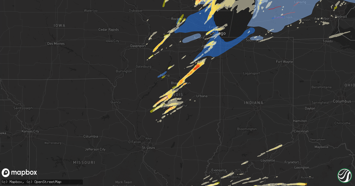
Hail Map in Illinois on May 15, 2025
Get this storm
May 15 map
$229
one time, instant access
Download today. No call, no setup
Keep the $229
Bought the map and want the full workflow? Apply the entire $229 to a subscription within 7 days. None of it is wasted.
Every map, not just this one
This buys you this map. Subscription and you get every map we run, in the markets you choose from a few cities to whole states to nationwide. Plus real-time alerts the moment a storm fires.
Contact data
Name, contact info, occupancy, even credit band for addresses in the footprint. You go from where it hit to who to call.
Become the source they trust
Unlimited branding weather history reports on demand. You already have the documented answer ready for the property owner, and you are the one who showed up with it.
Property data and RoofTrace estimates
Pull up any address you have got, its value and the exact code rules for that jurisdiction, straight from One Click Code. Then RoofTrace estimates the squares, pitch, and roof value, priced the way you price.
Storm reports in Illinois
Illinois
| Date | Description |
|---|---|
| 05/15/20256:59 PM CDT | Mesonet station ur707 broadwell. |
| 05/15/20256:59 PM CDT | A local report indicates 60 MPH wind near Mclean |
| 05/15/20256:59 PM CDT | Private weather station killelan2 reported 69 mph gust north of leland. |
| 05/15/20256:57 PM CDT | Private weather station reported 58 mph gust near wonder lake. |
| 05/15/20256:55 PM CDT | Public report of golf ball size hail near winthrop harbor. Relayed via mping. |
| 05/15/20256:54 PM CDT | Multiple public reports of hail up to 2 inches in diameter in winthrop harbor. |
| 05/15/20256:50 PM CDT | Public report of quarter size hail on the west side of zion. Time estimated by radar. |
| 05/15/20256:49 PM CDT | A local report indicates 1.00 inch wind near NWS Lincoln |
| 05/15/20256:48 PM CDT | Report from mping: quarter |
| 05/15/20256:48 PM CDT | A local report indicates 1.75 inch wind near 1 W Lincoln |
| 05/15/20256:47 PM CDT | Delayed report. Photos show a farm outbuilding completely destroyed... Power poles down... And sheet metal strewn about the property. A damage survey may be needed in t |
| 05/15/20256:45 PM CDT | Il-dot weather station north of marengo reported 65 mph gust. |
| 05/15/20256:44 PM CDT | Public report of quarter size hail in northern waukegan. |
| 05/15/20256:43 PM CDT | A large tree was split with half of the tree falling over. Golf ball sized hail also occurred around this time. Time estimated by radar. |
| 05/15/20256:43 PM CDT | Corrects loca |
| 05/15/20256:43 PM CDT | Corrects location on previous report from broadwell. |
| 05/15/20256:43 PM CDT | A local report indicates 1.75 inch wind near Broadwell |
| 05/15/20256:42 PM CDT | Trained spotter reported 2 inch hail on the west side of gurnee. |
| 05/15/20256:41 PM CDT | Trained spotter reports 16 inch diameter tree broken west of kingston. Time estimated by radar. |
| 05/15/20256:41 PM CDT | A local report indicates 1.75 inch wind near 1 W Waukegan |
| 05/15/20256:41 PM CDT | A local report indicates 1.00 inch wind near 5 W Washburn |
| 05/15/20256:40 PM CDT | Trained spotter reported quarter size hail on the south side of gurnee. Time estimated by radar. |
| 05/15/20256:40 PM CDT | Trained spotter reports measured 67 mph gust east of genoa. |
| 05/15/20256:40 PM CDT | Private weather station reported 59 mph gust north of sycamore. |
| 05/15/20256:38 PM CDT | Significant damage to a home. Power line down nearby. |
| 05/15/20256:38 PM CDT | Delayed report on social media with the time estimated by radar. A photo was provided. |
| 05/15/20256:38 PM CDT | Delayed report on social media with the time estimated by radar. A photo was provided. |
| 05/15/20256:38 PM CDT | Trees down. Social media report. |
| 05/15/20256:38 PM CDT | A local report indicates 1.50 inch wind near Elkhart |
| 05/15/20256:37 PM CDT | Corrects previous storm surge report from 1 s antioch. Trained spotter reports estimated 2.5 foot diameter tree broken and has fallen onto house. Time estimated by rada |
| 05/15/20256:36 PM CDT | Several photos relayed via social media of tree damage in and around dekalb. One photo showed a 1 foot in diameter tree snapped midway up. Live webcams at the time the |
| 05/15/20256:35 PM CDT | Report of two semi trucks blown over on i-155 near mile marker 3. Report was relayed by emergency manager and time was estimated by radar. |
| 05/15/20256:31 PM CDT | Public report of quarter size hail in belvidere. |
| 05/15/20256:31 PM CDT | Pictures received of a large tree down on a home causing damage to the siding on the back of the home in addition to the gutters and part of the roof. Time estimated fr |
| 05/15/20256:30 PM CDT | Numerous trees damaged... Along with some outbuildings. Time estimated from radar. |
| 05/15/20256:29 PM CDT | Time estimated by radar. |
| 05/15/20256:27 PM CDT | Scattered tree damage occurred throughout town. |
| 05/15/20256:27 PM CDT | A local report indicates 1.00 inch wind near Athens |
| 05/15/20256:27 PM CDT | Ping pong ball size hail at the city park. |
| 05/15/20256:26 PM CDT | Wind-driven hail damage to a residence north of athens. |
| 05/15/20256:25 PM CDT | Public report of small branches broken in vernon hills. Time estimated by radar. |
| 05/15/20256:25 PM CDT | 10 inch tree branch snapped. Time estimated by radar. |
| 05/15/20256:24 PM CDT | Private weather station kilroche3 reported 60 mph gust between rochelle and hillcrest. |
| 05/15/20256:24 PM CDT | Private weather station kilroche34 reported 60 mph gust north of rochelle. |
| 05/15/20256:23 PM CDT | Public report of tree damage between mchenry and volo. Time estimated by radar. |
| 05/15/20256:23 PM CDT | Sign blown over on highway 97 near hurie avenue... And farm shed destroyed on hurie avenue west of highway 97. |
| 05/15/20256:22 PM CDT | A local report indicates 60 MPH wind near 3 NW Peoria |
| 05/15/20256:22 PM CDT | Private weather station reported 64 mph gust northeast of rochelle. |
| 05/15/20256:20 PM CDT | A local report indicates 1.00 inch wind near Bartonville |
| 05/15/20256:15 PM CDT | Trained spotter reports branches 3-4 inch diameter broken. Time estimated by radar. |
| 05/15/20256:00 PM CDT | Several power poles leaning over onto the road resulting in power outages in the city. Photo submitted via social media... But location and damage confirmed by em. Time |
| 05/15/20255:42 PM CDT | Corrects previous hail report from 2 w deer grove. Many quarter size stones... But had a few close to golf balls. |
| 05/15/20255:42 PM CDT | Several quarter size stones... Some perhaps bigger. |
| 05/15/20255:38 PM CDT | Damage to house siding and windows... As well as cracking of a vehicle wind shield. Time estimated by radar. |
| 05/15/20255:25 PM CDT | Photo of several hailstones estimated to be around golf ball size shared via social media. Time estimated by radar. |
| 05/15/20255:06 PM CDT | Public report of quarter size hail near caledonia. Relayed by broadcast media. Time estimated by radar. |
| 05/15/20255:05 PM CDT | Mostly smaller stones... But had a few quarters. |
| 05/15/20255:05 PM CDT | Relayed from galva city esda. |
| 05/15/20255:05 PM CDT | Relayed from galva city esda. |
| 05/15/20255:05 PM CDT | Mostly sm |
| 05/15/20254:52 PM CDT | Powerlines down at the junction of sand road and garden plain road south of fulton. Time estimated by radar. |
| 05/15/20254:46 PM CDT | Rockford airport asos krfd recorded brief gust to 60 mph. |
| 05/14/20258:53 PM CDT | Asos station kcmi willard arpt. |
| 05/14/20258:29 PM CDT | Private weather station kilbeech29 reported 65 mph gust northeast of beecher. |
| 05/14/20258:27 PM CDT | Tree down over the road at springfield ave and state st... Relayed by broadcast media. Time was estimated with radar. |
| 05/14/20258:25 PM CDT | Steger ema reports damage to trees and damage to at least one residence. Time estimated by radar. |
| 05/14/20258:24 PM CDT | Damage to power lines and tree branches near crete. Relayed via will county ema. Time estimated by radar. |
| 05/14/20258:23 PM CDT | Raws weather station at midewin tallgrass prairie reported 59 mph gust. |
| 05/14/20258:20 PM CDT | Multiple reports of downed trees and tree limbs across the south chicago heights... Chatham... And cheltenham neighborhoods of chicago. Data collected from 311 request |
| 05/14/20258:20 PM CDT | A local report indicates 72 MPH wind near 1 E Burbank |
| 05/14/20258:19 PM CDT | Private weather station kiloakfo13 reported 68 mph gust at oak forest. |
| 05/14/20258:18 PM CDT | Monee ema reports tree and power line damage along timber lane west near monee. Time estimated by radar. |
| 05/14/20258:18 PM CDT | Monee ema reports tree and power line damage along timber lane west near monee. Time estimated by radar. Ed from radar. |
| 05/14/20258:17 PM CDT | Large tree branches downed in posen. Time estimated from radar. |
| 05/14/20258:17 PM CDT | Private weather station kilpeoto1 reported 62 mph gust. |
| 05/14/20258:15 PM CDT | Multiple reports of downed trees and tree limbs across the evergreen park... Beverly... Mount greenwood... Washington heights... And morgan park neighborhoods of chicag |
| 05/14/20258:15 PM CDT | Photos shared showing a tree snapped at its base in kennedy park in chicago. Time estimated from radar. |
| 05/14/20258:15 PM CDT | Photos showed on social media of large tree across roadway and on cars. The core of the tree appeared to be rotten. Time estimated by radar. |
| 05/14/20258:14 PM CDT | Multiple reports of trees snapped or uprooted in oak forest. Time estimated from radar. |
| 05/14/20258:13 PM CDT | Picture received of a large tree limb down in the road at the intersection of 151st street and kildare avenue. Time estimated from radar. |
| 05/14/20258:12 PM CDT | Report of a panel of a fence down near the intersection of 152nd street and kostner avenue. Time estimated from radar. |
| 05/14/20258:10 PM CDT | Photo shared on social media of 10 inch in diameter tree snapped. |
| 05/14/20258:10 PM CDT | Pictures of snapped trees at beverly and morgan park on the south side of chicago related via social media. Time estimated by radar. |
| 05/14/20258:10 PM CDT | Multiple reports of downed trees and tree limbs across the cornell... Cheltenham... And south chicago heights neighborhoods of chicago. Data collected from 311 request |
| 05/14/20258:08 PM CDT | Public report of 3 inch diameter branch broken near frankfort. Time estimated by radar. |
| 05/14/20258:07 PM CDT | Video shared to social media shows small branches broken near 45th and leamington avenue in garfield ridge community area of chicago. Time estimated by radar. |
| 05/14/20258:06 PM CDT | Photo of leaning power poles at 175th and harlem in tinley park. Time estimated by radar. |
| 05/14/20258:05 PM CDT | Video shared to social media shows small branch broken near 51st and mcvicker in garfield ridge community area of chicago. Time estimated by radar. |
| 05/14/20258:05 PM CDT | Via social media... Person posted pics of numerous branches down in backyard. |
| 05/14/20258:05 PM CDT | Multiple reports of downed trees and tree limbs across the beverly... Mount greenwood... Washington heights... And morgan park neighborhoods of chicago. Data collected |
| 05/14/20258:05 PM CDT | Several trees downed in palos heights. Time estimated from radar. |
| 05/14/20258:04 PM CDT | Photo shared to social media shows damage to roof trim and gutters of house near 167th and oak park avenue in tinley park. Time estimated by radar. |
| 05/14/20258:03 PM CDT | Private weather station kilmanha51 reported 64 mph gust south of manhattan. |
| 05/14/20258:03 PM CDT | Reports of a downed power line as well as extensive downed tree branches along 159th street in tinley park. Time estimated by radar. |
| 05/14/20258:03 PM CDT | Public report of a 8 foot diameter tree downed in oak lawn. Time estimated by radar radar. |
| 05/14/20258:03 PM CDT | Public report of large tree branches broken near 102nd street and alice court in oak lawn. Time estimated by radar. |
| 05/14/20258:03 PM CDT | Public report |
| 05/14/20258:03 PM CDT | Public report of quarter size hail in uptown area of chicago. Relayed via mping. |
| 05/14/20258:01 PM CDT | Power lines down and most of town without power. |
| 05/14/20258:01 PM CDT | Trained spotter reports 3-4 inch diameter branches broken... Power lines damaged... Trees snapped... And possible roof damage near sweedler road and gougar road in manh |
| 05/14/20258:01 PM CDT | Three gusts in excess of 70 mph measured on home weather station. The peak gust was 73.6 mph. |
| 05/14/20258:00 PM CDT | Public report of a large tree snapped in the edgewater area of chicago. |
| 05/14/20258:00 PM CDT | Private weather station kilchica577 reported 59 mph gust. |
| 05/14/20258:00 PM CDT | Public works reported snapped 14 diameter branch on crawford street. |
| 05/14/20258:00 PM CDT | Via social media... User posted an image of a hail stone next to a ruler measuring 1 inch. |
| 05/14/20257:59 PM CDT | Public report of half dollar size hail near homer glen. Relayed via mping. |
| 05/14/20257:59 PM CDT | Public report of half dollar size hail near homer glen. R |
| 05/14/20257:57 PM CDT | Report of a telephone pole broken and wires down was relayed by local law enforcement. Time was estimated by radar. |
| 05/14/20257:57 PM CDT | Large tree and wires down across the road report was relayed by local law enforcement. Time was estimated by radar. |
| 05/14/20257:57 PM CDT | Wires down was relayed by local law enforcement. Time was estimated by radar. |
| 05/14/20257:54 PM CDT | Private weather station kilchica929 reported 59 mph gust. |
| 05/14/20257:52 PM CDT | Photo shared to social media shows large section of roof material blown into a street in the business district of wilmington. Time estimated by radar. |
| 05/14/20257:52 PM CDT | Numerous reports of tree damage in and near wilmington. Fascia damage reported to a house as well. Time estimated from radar. |
| 05/14/20257:52 PM CDT | Photo showing the roof above the front porch of a house partially collapsed in lakewood shores. Time estimated from radar. |
| 05/14/20257:52 PM CDT | Photo shared of a 2 foot in diameter tree uprooted in the andersonville neighborhood of chicago. Several other reports of downed trees were received in the same general |
| 05/14/20257:52 PM CDT | Photo shared to social media shows numerous large branches broken near kennedy expressway |
| 05/14/20257:52 PM CDT | Private weather station reported 60 mph gust in jefferson park area of chicago. |
| 05/14/20257:50 PM CDT | Fascia peeled off of house in essex. Time estimated from radar. |
| 05/14/20257:47 PM CDT | Photo shared via social media shows roof and walls peeled from metal farm building along n 3500 e road west of cabery. Debris blown into a field. Time estimated by rada |
| 05/14/20257:47 PM CDT | Brick chimney of house demolished in braidwood. Time estimated from radar. |
| 05/14/20257:47 PM CDT | Photo shared via social media shows roof and walls peeled from metal farm building along n 3500 e road west of cabery. Debris blown into a fiel |
| 05/14/20257:46 PM CDT | Large tree branch broken east of decatur... And power lines down. Time estimated from radar. |
| 05/14/20257:46 PM CDT | Multiple trees and large tree limbs downed in the portage park community area of chicago. Time estimated from radar. |
| 05/14/20257:46 PM CDT | Public report of possible damage to tree branches and siding of a building near braceville. Time estimated by radar. |
| 05/14/20257:46 PM CDT | Numerous trees and power lines down. 5-6 homes with trees down onto roofs and several with shingle damage. |
| 05/14/20257:46 PM CDT | Corrects previous report from braceville. Public report of possible damage to tree branches and siding of a building near braceville. Time estimated by radar. |
| 05/14/20257:45 PM CDT | Photo showing large tree limb downed onto canfield avenue at talcott road. Time estimated from radar. |
| 05/14/20257:45 PM CDT | Photo shared to social media shows large tree snapped at the base and damage to at least one nearby car in dunning community area of chicago. Time estimated by radar. |
| 05/14/20257:45 PM CDT | Multiple reports of downed trees and tree limbs across the norwood park neighborhood of chicago. Data collected from 311 request map. Time estimated by radar. |
| 05/14/20257:44 PM CDT | Multiple wind gusts in excess of 75 mph with a peak gust of 78.7 mph. |
| 05/14/20257:44 PM CDT | Photo shared to social media shows baseball size hail near eming |
| 05/14/20257:44 PM CDT | Photo shared to social media shows baseball size hail near emington. Time estimated by radar. |
| 05/14/20257:43 PM CDT | Power lines down and large tree branch broken off on west side of decatur. |
| 05/14/20257:43 PM CDT | Report shared via social media indicates tree damage near belmont avenue and lincoln street in franklin park. Time estimated by radar. |
| 05/14/20257:41 PM CDT | Photo shows 3 inch diameter hail near il-47 and e 2100 n road north of saunemin. Time estimated by radar. Report relayed by broadcast media. |
| 05/14/20257:40 PM CDT | Delayed report. Power poles blown down. Time estimated by radar. |
| 05/14/20257:40 PM CDT | Delayed report. Power poles blown down. Time estimated by radar. |
| 05/14/20257:40 PM CDT | Trained spotter reports hail up to half dollar size near franklin park. |
| 05/14/20257:40 PM CDT | Delayed report. Power poles blown down. Time estimated by radar. |
| 05/14/20257:39 PM CDT | Photo shared via social media shows tennis ball size hail near saunemin. Time estimated by radar. |
| 05/14/20257:38 PM CDT | Photos relayed via social media depict trees around 1 to 2 feet in diameter downed on power lines in gardner. Time estimated by radar. |
| 05/14/20257:38 PM CDT | Time estimated from radar. |
| 05/14/20257:37 PM CDT | Public report of half dollar hail in elmhurst. Relayed via mping. |
| 05/14/20257:37 PM CDT | Public report of quarter size hail in villa park. Relayed via mping. |
| 05/14/20257:37 PM CDT | Public report of half dollar hail in elmhurst. |
| 05/14/20257:35 PM CDT | Trees downed in villa park. Wind-driven quarter size hail also caused damage to siding on house. Time estimated from radar. |
| 05/14/20257:34 PM CDT | Large tree branches and limbs snapped off trees in dwight. Time estimated from radar. |
| 05/14/20257:33 PM CDT | 12 telephone poles downed and there is damage to a nearby solar farm. |
| 05/14/20257:33 PM CDT | Photo showing uprooted tree in lombard. Time estimated from radar. |
| 05/14/20257:30 PM CDT | Tree uprooted. Social media report. Time estimated from radar. |
| 05/14/20257:30 PM CDT | Trained spotter reports downed traffic light near finley road and eisenhower lane in lombard. Time estimated by radar. |
| 05/14/20257:30 PM CDT | Photo on social media of hail stone reported in glen ellyn next to ruler. Time estimated by users post. |
| 05/14/20257:28 PM CDT | Time estimated from radar. |
| 05/14/20257:27 PM CDT | Hail from quarter to golf ball size. Social media report. |
| 05/14/20257:25 PM CDT | Hail this fell for approximately two minutes. |
| 05/14/20257:25 PM CDT | Hail this size fell for approximately two minutes. |
| 05/14/20257:23 PM CDT | A local report indicates 1.75 inch wind near Chenoa |
| 05/14/20257:22 PM CDT | Estimated from pictures posted on social media. |
| 05/14/20257:20 PM CDT | Mesonet station fw2710 towanda. |
| 05/14/20257:20 PM CDT | Along highway 29 between rochester and berry. Social media report. |
| 05/14/20257:18 PM CDT | A local report indicates 65 MPH wind near 3 WSW Chenoa |
| 05/14/20257:15 PM CDT | Photo shared to social media shows small tree snapped in port barrington. Time estimated by radar. |
| 05/14/20257:15 PM CDT | 4 power poles down east of mechanicsburg. Time estimated from radar. |
| 05/14/20257:11 PM CDT | A local report indicates 1.00 inch wind near 3 N Shirley |
| 05/14/20257:11 PM CDT | A local report indicates 1.00 inch wind near 1 E Normal |
| 05/14/20257:11 PM CDT | Report from mping: golf ball |
| 05/14/20257:10 PM CDT | A local report indicates 1.50 inch wind near 1 SW Normal |
| 05/14/20257:08 PM CDT | A local report indicates 1.75 inch wind near Normal |
| 05/14/20257:08 PM CDT | A local report indicates 2.00 inch wind near 2 E Central Illinois Ai |
| 05/14/20257:08 PM CDT | A local report indicates 1.75 inch wind near 1 W Bloomington |
| 05/14/20257:08 PM CDT | Corrects location of previous report from 2 e central illinois airport. |
| 05/14/20257:08 PM CDT | Report from mping: half dollar |
| 05/14/20257:06 PM CDT | A local report indicates 1.00 inch wind near Normal |
| 05/14/20257:06 PM CDT | A local report indicates 1.00 inch wind near 2 NNW Central Illinois |
| 05/14/20257:06 PM CDT | Social media report with photo provided measuring the hail with a ruler. Time estimated by radar. |
| 05/14/20257:05 PM CDT | Photo provided measuring the hail. Time estimated by radar. |
| 05/14/20257:05 PM CDT | Delayed report on social media with the time estimated by radar. A photo was provided. |
| 05/14/20257:05 PM CDT | Report from mping: quarter |
| 05/14/20257:05 PM CDT | Report from mping: quarter |
| 05/14/20257:05 PM CDT | A local report indicates 1.00 inch wind near Bloomington |
| 05/14/20257:04 PM CDT | Private w |
| 05/14/20257:04 PM CDT | Report from mping: golf ball |
| 05/14/20257:04 PM CDT | Private weather station killakev22 reported 62 mph gust near fox lake hills. |
| 05/14/20257:03 PM CDT | A local report indicates 1.25 inch wind near 3 SW Bloomington |
| 05/14/20257:03 PM CDT | Report from mping: half dollar |
| 05/14/20257:02 PM CDT | A local report indicates 1.00 inch wind near 3 N Shirley |
| 05/14/20257:02 PM CDT | Photo shared showing an uprooted tree in spring grove. Fencing was also blown over at the same residence. Time estimated from radar. |
| 05/14/20257:00 PM CDT | A local report indicates 1.00 inch wind near 3 NE Shirley |
All States Impacted by Hail Map on May 15, 2025
Cities Impacted by Hail Map on May 15, 2025
- Broken Bow, OK
- Silver Lake, MN
- Lester Prairie, MN
- Glencoe, MN
- Watson, OK
- Cove, AR
- Wickes, AR
- Lake Crystal, MN
- Vandervoort, AR
- Mena, AR
- Elk River, MN
- Big Lake, MN
- Zimmerman, MN
- Princeton, MN
- Anoka, MN
- Saint Francis, MN
- Cambridge, MN
- Isanti, MN
- Stanchfield, MN
- Dalbo, MN
- Ogilvie, MN
- Braham, MN
- Mora, MN
- Grasston, MN
- Brook Park, MN
- Howe, OK
- Poteau, OK
- Cleveland, MN
- Elysian, MN
- Hackett, AR
- Heavener, OK
- Midland, AR
- Mansfield, AR
- Huntington, AR
- Hartford, AR
- Magazine, AR
- Paris, AR
- Subiaco, AR
- Brockwell, AR
- Delaware, AR
- London, AR
- Knoxville, AR
- Hagarville, AR
- Deer, AR
- New Blaine, AR
- Russellville, AR
- Dover, AR
- Witts Springs, AR
- Marshall, AR
- Wiseman, AR
- Horseshoe Bend, AR
- Ash Flat, AR
- Violet Hill, AR
- Lamar, AR
- Scranton, AR
- Mount Judea, AR
- Franklin, AR
- Pelsor, AR
- Cherokee Village, AR
- Hardy, AR
- Sage, AR
- Evening Shade, AR
- Jerusalem, AR
- Hector, AR
- Scotland, AR
- Clinton, AR
- Leslie, AR
- Ravenden Springs, AR
- Ravenden, AR
- Harriet, AR
- Big Flat, AR
- Timbo, AR
- Onia, AR
- Dennard, AR
- Pocahontas, AR
- Williford, AR
- Oronoco, MN
- Rochester, MN
- Zumbro Falls, MN
- Mazeppa, MN
- Maynard, AR
- Long Lake, MN
- Hamel, MN
- Doniphan, MO
- Byron, MN
- Fox, AR
- Shirley, AR
- New London, MN
- Belgrade, MN
- Mountain View, AR
- Melbourne, AR
- Fifty Six, AR
- Warm Springs, AR
- Cannon Falls, MN
- Elgin, MN
- Imboden, AR
- Pollocksville, NC
- Pine Island, MN
- Marcella, AR
- Batesville, AR
- Edgemont, AR
- South Saint Paul, MN
- Inver Grove Heights, MN
- Locust Grove, AR
- Welch, MN
- Minneapolis, MN
- Mount Pleasant, AR
- Guion, AR
- Millville, MN
- Andover, MN
- Nelson, WI
- Cedar, MN
- Bethel, MN
- New Bern, NC
- Paynesville, MN
- Melrose, MN
- Houston, MN
- Wabasha, MN
- Stillwater, MN
- Onamia, MN
- Cottage Grove, MN
- Saint Paul, MN
- Winona, MN
- Trempealeau, WI
- Galesville, WI
- Arcadia, WI
- Fountain City, WI
- Dodge, WI
- Durand, WI
- Freeport, MN
- Selma, NC
- Kenly, NC
- Alma, WI
- Lake City, MN
- Wyoming, MN
- Pepin, WI
- Kellogg, MN
- Stockholm, WI
- Dakota, MN
- Albany, MN
- Lake Elmo, MN
- Prescott, WI
- River Falls, WI
- Hastings, MN
- Arkansaw, WI
- Plum City, WI
- Avoca, WI
- Highland, WI
- Eau Galle, WI
- Menomonie, WI
- Ettrick, WI
- Independence, WI
- Blair, WI
- Bock, MN
- Milaca, MN
- Isle, MN
- Spring Green, WI
- Lone Rock, WI
- Lansing, IA
- Waukon, IA
- Pine City, MN
- Hudson, WI
- Roberts, WI
- New Richmond, WI
- Reads Landing, MN
- Elmwood, WI
- Hillpoint, WI
- Plain, WI
- Cazenovia, WI
- La Valle, WI
- Reedsburg, WI
- Deer Park, WI
- Sauk City, WI
- Amery, WI
- Star Prairie, WI
- Dodgeville, WI
- McGrath, MN
- Richland Center, WI
- Mondovi, WI
- Cochrane, WI
- New Albin, IA
- Aitkin, MN
- Bee Branch, AR
- Holmen, WI
- Eleva, WI
- Eau Claire, WI
- Whitehall, WI
- Wonewoc, WI
- North Freedom, WI
- Loganville, WI
- Rock Springs, WI
- Dalton, MN
- Ashby, MN
- Fergus Falls, MN
- Underwood, MN
- Battle Lake, MN
- Erhard, MN
- Pelican Rapids, MN
- Dent, MN
- Evansville, MN
- Brooklyn, WI
- Oregon, WI
- Mazomanie, WI
- Bemidji, MN
- Quitman, AR
- Heber Springs, AR
- Damascus, AR
- Elk Mound, WI
- Pikeville, NC
- Fremont, NC
- Dresser, WI
- Osceola, WI
- Hinckley, MN
- Eitzen, MN
- Balsam Lake, WI
- Saint Croix Falls, WI
- Hillsboro, WI
- Viola, WI
- Lucama, NC
- Belleville, WI
- Monticello, WI
- Albany, WI
- Mauston, WI
- Verona, WI
- Madison, WI
- Ferrum, VA
- Rocky Mount, VA
- Henry, VA
- Stoughton, WI
- Mcfarland, WI
- Milltown, WI
- Centuria, WI
- Fall Creek, WI
- Friendship, WI
- Mcgregor, MN
- Floral, AR
- Lowland, NC
- Hobucken, NC
- Turtle Lake, WI
- Manns Harbor, NC
- Prairie Du Sac, WI
- New Lisbon, WI
- Adams, WI
- Strum, WI
- Altoona, WI
- Wilburn, AR
- Tumbling Shoals, AR
- Drasco, AR
- Lime Ridge, WI
- Sulphur Rock, AR
- Sparta, WI
- Rockland, WI
- Cushing, WI
- Viroqua, WI
- Chaseburg, WI
- Baraboo, WI
- Charlotte, AR
- Hixton, WI
- Alma Center, WI
- Taylor, WI
- Black River Falls, WI
- Merrimac, WI
- Clayton, WI
- Clear Lake, WI
- Ontario, WI
- Wheeler, WI
- Ridgeland, WI
- Kendall, WI
- La Farge, WI
- Rose Bud, AR
- Manteo, NC
- Nags Head, NC
- Colfax, WI
- Cottage Grove, WI
- Chippewa Falls, WI
- Cross Plains, WI
- Middleton, WI
- Waunakee, WI
- Dane, WI
- Deforest, WI
- Lodi, WI
- Barron, WI
- Dallas, WI
- Elroy, WI
- Rocky Mount, NC
- Oil Trough, AR
- Wilton, WI
- Finlayson, MN
- Comstock, WI
- Fairchild, WI
- Humbird, WI
- Merrillan, WI
- Necedah, WI
- Arkdale, WI
- Cashton, WI
- Warrens, WI
- Pleasant Plains, AR
- Rosie, AR
- Tomah, WI
- Camp Douglas, WI
- Windsor, WI
- Cord, AR
- Tuckerman, AR
- Newark, AR
- Bradford, AR
- Thida, AR
- Magness, AR
- Newport, AR
- Pangburn, AR
- Westby, WI
- Havelock, NC
- Almena, WI
- Bloomer, WI
- Poynette, WI
- Osseo, WI
- Sun Prairie, WI
- Cameron, WI
- Chetek, WI
- Rice Lake, WI
- Willard, WI
- Arlington, WI
- Jim Falls, WI
- Hayward, WI
- Davis Junction, IL
- Stillman Valley, IL
- Valliant, OK
- Tarboro, NC
- Macclesfield, NC
- Lyndon Station, WI
- Wisconsin Dells, WI
- Portage, WI
- Norwalk, WI
- Lewiston Woodville, NC
- Nekoosa, WI
- Barneveld, WI
- Neillsville, WI
- Pardeeville, WI
- Wanchese, NC
- Swifton, AR
- Wright City, OK
- Cadott, WI
- Cornell, WI
- Rio, WI
- Savanna, IL
- Cash, AR
- Endeavor, WI
- Montello, WI
- Greenwood, WI
- Chili, WI
- Marshfield, WI
- Granton, WI
- Eagle, WI
- Palmyra, WI
- East Troy, WI
- Pittsville, WI
- Elizabeth, IL
- Hanover, IL
- Windsor, NC
- Elkhorn, WI
- Whitewater, WI
- Deerfield, WI
- Columbia, NC
- Rockford, IL
- Monroe Center, IL
- Oneida, IL
- Columbus, WI
- Albany, IL
- Minong, WI
- Marshall, WI
- Hancock, WI
- Wyocena, WI
- Cambria, WI
- Altona, IL
- Woodhull, IL
- Galva, IL
- Bishop Hill, IL
- Cambridge, IL
- Kewanee, IL
- Backus, MN
- Waterloo, WI
- Bethel, NC
- Greenville, NC
- Harrisonburg, VA
- Erie, IL
- Fenton, IL
- Holcombe, WI
- Fulton, IL
- Morrison, IL
- Wisconsin Rapids, WI
- Oak City, NC
- Cordova, IL
- Aulander, NC
- Robersonville, NC
- Stumpy Point, NC
- Weiner, AR
- Hillsdale, IL
- Hobgood, NC
- Loyal, WI
- Owen, WI
- Hamilton, NC
- Markesan, WI
- Dalton, WI
- Cherry Valley, IL
- Poplar Grove, IL
- Belvidere, IL
- Loves Park, IL
- Caledonia, IL
- Fall River, WI
- Doylestown, WI
- Bancroft, WI
- Plainfield, WI
- Randolph, WI
- Atkinson, IL
- Annawan, IL
- Friesland, WI
- Prophetstown, IL
- Tampico, IL
- Mineral, IL
- Dousman, WI
- Oconomowoc, WI
- Williamston, NC
- Waukesha, WI
- Wales, WI
- Stokes, NC
- Delafield, WI
- Hartland, WI
- Elkton, VA
- Colby, WI
- Dayton, VA
- Broadway, VA
- Rudolph, WI
- Reeseville, WI
- Capron, IL
- Beaver Dam, WI
- Port Edwards, WI
- Nashotah, WI
- Pewaukee, WI
- Hartford, WI
- Colgate, WI
- Lowell, WI
- Watertown, WI
- Juneau, WI
- Briggsville, WI
- Unity, WI
- Spencer, WI
- Stratford, WI
- Wahkon, MN
- Sheffield, IL
- Port Republic, VA
- McGaheysville, VA
- Penn Laird, VA
- Arpin, WI
- Vesper, WI
- Abbotsford, WI
- Dorchester, WI
- Athens, WI
- Edgar, WI
- Babcock, WI
- Curtiss, WI
- Stevens Point, WI
- Sussex, WI
- Oxford, WI
- Deer Grove, IL
- Harmon, IL
- Rock Falls, IL
- Dixon, IL
- Keezletown, VA
- Monroe, WI
- Hubertus, WI
- North Prairie, WI
- Washington, NC
- Richfield, WI
- Slinger, WI
- Colerain, NC
- Burnett, WI
- Junction City, WI
- Creswell, NC
- Kingston, WI
- Merry Hill, NC
- Ahoskie, NC
- Helenville, WI
- Lake Geneva, WI
- Edenton, NC
- Horicon, WI
- Sterling, IL
- Plover, WI
- Burlington, WI
- Mukwonago, WI
- Crozet, VA
- Free Union, VA
- Waterford, WI
- Big Bend, WI
- Allenton, WI
- West Bend, WI
- Kewaskum, WI
- Sullivan, WI
- Princeton, IL
- Ohio, IL
- Ixonia, WI
- Oregon, IL
- Franklin Grove, IL
- Alexander, IL
- Mayville, WI
- Lebanon, WI
- Iron Ridge, WI
- Theresa, WI
- Rubicon, WI
- Ashippun, WI
- Neosho, WI
- Mosinee, WI
- Neshkoro, WI
- Springfield, WI
- Ashton, IL
- Chana, IL
- Grottoes, VA
- Chocowinity, NC
- Lomira, WI
- Brownsville, WI
- Pleasant Plains, IL
- Petersburg, IL
- Tallula, IL
- Athens, IL
- Blounts Creek, NC
- Franklin, IL
- Jacksonville, IL
- New Berlin, IL
- Waverly, IL
- Springfield, IL
- Greenview, IL
- Campbellsport, WI
- Fond Du Lac, WI
- Eden, WI
- Dalzell, IL
- Lowpoint, IL
- Tremont, IL
- Morton, IL
- Lacon, IL
- Magnolia, IL
- Peru, IL
- Groveland, IL
- East Peoria, IL
- Washburn, IL
- Pekin, IL
- San Jose, IL
- Delavan, IL
- Spring Valley, IL
- Metamora, IL
- Washington, IL
- Mason City, IL
- McNabb, IL
- Mendota, IL
- Green Valley, IL
- Granville, IL
- Varna, IL
- New Holland, IL
- Middletown, IL
- Kirkland, IL
- Holcomb, IL
- Rochelle, IL
- Wautoma, WI
- Ashland, IL
- Schofield, WI
- Rothschild, WI
- Barrington, IL
- Lake Zurich, IL
- Palatine, IL
- Muskego, WI
- Coloma, WI
- Brandon, WI
- Ripon, WI
- Manlius, IL
- Walnut, IL
- Milwaukee, WI
- Greendale, WI
- La Moille, IL
- Oakfield, WI
- Hustisford, WI
- Ringle, WI
- Hanna City, IL
- Glasford, IL
- Mapleton, IL
- Peoria, IL
- Peoria Heights, IL
- Princeton, WI
- Elkhart, IL
- Green Lake, WI
- Cantrall, IL
- Sherman, IL
- Franksville, WI
- Clare, IL
- Malta, IL
- Esmond, IL
- Lindenwood, IL
- Kingston, IL
- Sycamore, IL
- Charlottesville, VA
- Garden Prairie, IL
- Gurnee, IL
- Waukegan, IL
- New Berlin, WI
- Franklin, WI
- Hales Corners, WI
- Zion, IL
- Wadsworth, IL
- Pleasant Prairie, WI
- Salem, WI
- Menomonee Falls, WI
- Antioch, IL
- Lincoln, IL
- Wausau, WI
- Marathon, WI
- Union Grove, WI
- Mequon, WI
- Amherst, WI
- Almond, WI
- Lake Bluff, IL
- Vernon Hills, IL
- Libertyville, IL
- North Chicago, IL
- Mundelein, IL
- Kansasville, WI
- Custer, WI
- Rosholt, WI
- Germantown, WI
- Wild Rose, WI
- Fairwater, WI
- Lannon, WI
- Kenosha, WI
- Jackson, WI
- Grafton, WI
- Oak Creek, WI
- Racine, WI
- Winthrop Harbor, IL
- Sturtevant, WI
- Caledonia, WI
- Atlanta, IL
- Lawndale, IL
- Edward, NC
- Amherst Junction, WI
- Armington, IL
- McLean, IL
- Stanford, IL
- Shirley, IL
- Bloomington, IL
- Normal, IL
- Williamsville, IL
- Butler, WI
- Brookfield, WI
- Random Lake, WI
- Adell, WI
- Shiloh, NC
- Shawboro, NC
- Hartsburg, IL
- Waldo, WI
- Saint Cloud, WI
- Glenbeulah, WI
- Paw Paw, IL
- Twin Lakes, WI
- Genoa City, WI
- Bristol, WI
- La Rose, IL
- Elm Grove, WI
- Emden, IL
- Nelsonville, WI
- Cedarburg, WI
- South Milwaukee, WI
- Towanda, IL
- Lexington, IL
- Hudson, IL
- Saint Francis, WI
- Cudahy, WI
- Aurora, NC
- Aydlett, NC
- Grandy, NC
- Coinjock, NC
- Poplar Branch, NC
- Rochester, WI
- Cedar Grove, WI
- Oostburg, WI
- Plymouth, WI
- Girard, IL
- Palmyra, IL
- Riverton, IL
- Redgranite, WI
- Virden, IL
- Saukville, WI
- Mount Pulaski, IL
- Grantsboro, NC
- Cascade, WI
- Elizabeth City, NC
- Linville, VA
- Shenandoah, VA
- Divernon, IL
- Auburn, IL
- Merrill, WI
- Carlinville, IL
- Dawson, IL
- Buffalo, IL
- Port Washington, WI
- Belgium, WI
- Hinton, VA
- Mchenry, IL
- Iola, WI
- Waynesville, IL
- Fredonia, WI
- Gridley, IL
- Chenoa, IL
- Fairbury, IL
- Lombard, IL
- Glen Ellyn, IL
- Sheboygan Falls, WI
- Latham, IL
- Maroa, IL
- Edinburg, IL
- Rochester, IL
- Pawnee, IL
- Sheboygan, WI
- Cleveland, WI
- Heyworth, IL
- Corolla, NC
- Manitowoc, WI
- Finland, MN
- Illiopolis, IL
- Mount Calvary, WI
- Naperville, IL
- Mechanicsburg, IL
- Kenney, IL
- Chestnut, IL
- Waggoner, IL
- Streator, IL
- Grand Ridge, IL
- Great Lakes, IL
- Odell, IL
- Cornell, IL
- Ringwood, IL
- Farmersville, IL
- Grayslake, IL
- Villa Park, IL
- Elmhurst, IL
- Berkeley, IL
- Addison, IL
- Lake Forest, IL
- Melrose Park, IL
- Chicago, IL
- Franklin Park, IL
- River Grove, IL
- Stone Park, IL
- Schiller Park, IL
- Pontiac, IL
- Saunemin, IL
- Forrest, IL
- Harwood Heights, IL
- Mount Auburn, IL
- Flanagan, IL
- Gardner, IL
- Dwight, IL
- Downs, IL
- Ellsworth, IL
- Two Rivers, WI
- Downers Grove, IL
- Oak Brook, IL
- Kohler, WI
- Elwood, IL
- Lisle, IL
- Blue Mound, IL
- Warrensburg, IL
- Niantic, IL
- Decatur, IL
- Campus, IL
- Reddick, IL
- Buckingham, IL
- Cullom, IL
- Cabery, IL
- Emington, IL
- Kempton, IL
- Herscher, IL
- Braceville, IL
- New Lenox, IL
- Joliet, IL
- Woodridge, IL
- Darien, IL
- Lemont, IL
- Braidwood, IL
- Wilmington, IL
- Willowbrook, IL
- Homer Glen, IL
- Orland Park, IL
- Lockport, IL
- Mokena, IL
- Skokie, IL
- Elmwood Park, IL
- Hillside, IL
- Lincolnwood, IL
- Evanston, IL
- Forsyth, IL
- Oreana, IL
- Bolingbrook, IL
- New Auburn, WI
- Tinley Park, IL
- Palos Heights, IL
- Oak Forest, IL
- Palos Park, IL
- Crestwood, IL
- Midlothian, IL
- Wheaton, IL
- River Forest, IL
- Maywood, IL
- Bellwood, IL
- Oak Park, IL
- Bensenville, IL
- Morton Grove, IL
- Niles, IL
- Park Ridge, IL
- Fulks Run, VA
- Haugen, WI
- Sarona, WI
- Birchwood, WI
- Frankfort, IL
- Monee, IL
- Oak Lawn, IL
- Alsip, IL
- Willow Springs, IL
- La Grange, IL
- Union Hill, IL
- Bonfield, IL
- Manhattan, IL
- Macon, IL
- Boody, IL
- Monticello, IL
- Bridgeview, IL
- Summit Argo, IL
- Burbank, IL
- Justice, IL
- Essex, IL
- Climax, MN
- Singers Glen, VA
- Reynolds, ND
- Grand Forks, ND
- Thompson, ND
- Creve Coeur, IL
- East Grand Forks, MN
- Fisher, MN
- Hometown, IL
- Evergreen Park, IL
- Markham, IL
- Country Club Hills, IL
- Hazel Crest, IL
- Ivesdale, IL
- Sadorus, IL
- Posen, IL
- Blue Island, IL
- Harvey, IL
- Matteson, IL
- Robbins, IL
- Kankakee, IL
- Bradley, IL
- Bourbonnais, IL
- Spring Lake, MI
- Grand Haven, MI
- South Wilmington, IL
- Coal City, IL
- Mazon, IL
- Luck, WI
- Manteno, IL
- Peotone, IL
- Lowell, IN
- Cedar Lake, IN
- Beecher, IL
- University Park, IL
- Saint John, IN
- Crete, IL
- Crown Point, IN
- Dyer, IN
- Grant Park, IL
- Minnesota City, MN
- Holland, MI
- West Olive, MI
- Macatawa, MI
- Muskegon, MI
- Whitehall, MI
- Coopersville, MI
- Ravenna, MI
- Twin Lake, MI
- Nunica, MI
- Fruitport, MI
- Conklin, MI
- Zeeland, MI
- Allendale, MI
- Fennville, MI
- Pullman, MI
- Success, AR
- Hudsonville, MI
- Jenison, MI
- Marne, MI
- Casnovia, MI
- Grand Rapids, MI
- Sparta, MI
- Grant, MI
- Holton, MI
- Newaygo, MI
- Fremont, MI
- Bailey, MI
- Kent City, MI
- Auburndale, WI
- Milladore, WI
- Saugatuck, MI
- Douglas, MI
- South Haven, MI
- Coloma, MI
- Covert, MI
- Saint Joseph, MI
- Benton Harbor, MI
- Hamilton, MI
- Bangor, MI
- Grand Junction, MI
- Watervliet, MI
- Hartford, MI
- Cedar Springs, MI
- Comstock Park, MI
- Howard City, MI
- Sand Lake, MI
- White Cloud, MI
- Port Byron, IL
- Neponset, IL
- Wyanet, IL
- Morley, MI
- Pierson, MI
- Rockford, MI
- Grandville, MI
- Coral, MI
- Belmont, MI
- Trufant, MI
- Byron Center, MI
- Wyoming, MI
- Dorr, MI
- Ada, MI
- Shelbyville, MI
- Wayland, MI
- Lawrence, MI
- Caledonia, MI
- Hopkins, MI
- Allegan, MI
- Bloomingdale, MI
- Gobles, MI
- Otsego, MI
- Mattawan, MI
- Decatur, MI
- Paw Paw, MI
- Dowagiac, MI
- Sodus, MI
- Eau Claire, MI
- Grand Marsh, WI
- Martin, MI
- Plainwell, MI
- Anderson, SC
- Buchanan, MI
- Baroda, MI
- Berrien Springs, MI
- Lakeview, MI
- Stanton, MI
- Six Lakes, MI
- Edmore, MI
- Alto, MI
- Belding, MI
- Greenville, MI
- Lowell, MI
- Middleville, MI
- Sidney, MI
- Gowen, MI
- Sheridan, MI
- Lawton, MI
- Portage, MI
- Kalamazoo, MI
- Delton, MI
- Pendleton, SC
- Richland, MI
- Hastings, MI
- Fenwick, MI
- Saranac, MI
- Orleans, MI
- Freeport, MI
- Camden, NC
- Galesburg, MI
- Battle Creek, MI
- Taylorville, IL
- Stonington, IL
- South Bend, IN
- Granger, IN
- Niles, MI
- Bellevue, MI
- Elwell, MI
- Vestaburg, MI
- Riverdale, MI
- Sumner, MI
- Blanchard, MI
- Saint Louis, MI
- Crystal, MI
- Alma, MI
- Middleton, MI
- Ionia, MI
- Ithaca, MI
- Hubbardston, MI
- Carson City, MI
- Muir, MI
- Sunfield, MI
- Portland, MI
- Lake Odessa, MI
- Pewamo, MI
- Clarksville, MI
- Perrinton, MI
- Lyons, MI
- Fowler, MI
- Westphalia, MI
- Woodland, MI
- Grand Ledge, MI
- Mulliken, MI
- Charlotte, MI
- Vermontville, MI
- Nashville, MI
- Olivet, MI
- Climax, MI
- Hickory Corners, MI
- Ceresco, MI
- Dowling, MI
- Marshall, MI
- Augusta, MI
- Schoolcraft, MI
- Burlington, MI
- Marcellus, MI
- Athens, MI
- East Leroy, MI
- Vicksburg, MI
- Fulton, MI
- Scotts, MI
- Gotham, WI
- Potterville, MI
- Eaton Rapids, MI
- Elkhart, IN
- Jones, MI
- Three Rivers, MI
- Edwardsburg, MI
- Osceola, IN
- Mishawaka, IN
- Lansing, MI
- Union City, MI
- Parma, MI
- Homer, MI
- Concord, MI
- Springport, MI
- Tekonsha, MI
- Albion, MI
- Rives Junction, MI
- Mason, MI
- Leslie, MI
- Dimondale, MI
- Okemos, MI
- Eagle, MI
- East Lansing, MI
- Onondaga, MI
- Holt, MI
- Bath, MI
- Saint Johns, MI
- Laingsburg, MI
- Dewitt, MI
- Haslett, MI
- Pompeii, MI
- Maple Rapids, MI
- Ashley, MI
- Elsie, MI
- North Star, MI
- Mendon, MI
- Centreville, MI
- Cassopolis, MI
- Colon, MI
- Sturgis, MI
- Sherwood, MI
- Leonidas, MI
- Constantine, MI
- White Pigeon, MI
- Bristol, IN
- Goshen, IN
- Vandalia, MI
- Ovid, MI
- Owosso, MI
- Oakley, MI
- Bannister, MI
- Henderson, MI
- Jackson, MI
- Bancroft, MI
- Dansville, MI
- Stockbridge, MI
- Fowlerville, MI
- Webberville, MI
- Williamston, MI
- Perry, MI
- Corunna, MI
- Morrice, MI
- Munith, MI
- Grass Lake, MI
- Pleasant Lake, MI
- Middlebury, IN
- Shipshewana, IN
- Howell, MI
- Fenton, MI
- West Bloomfield, MI
- Southfield, MI
- Linden, MI
- Tovey, IL
- Glenarm, IL
- Bronson, MI
- Burr Oak, MI
- Gregory, MI
- Durand, MI
- Byron, MI
- Swartz Creek, MI
- Grand Blanc, MI
- Flint, MI
- Vernon, MI
- Gaines, MI
- Lennon, MI
- Flushing, MI
- New Lothrop, MI
- Burton, MI
- Chesaning, MI
- Holly, MI
- Davison, MI
- Troy, MI
- Pontiac, MI
- Rochester, MI
- Bloomfield Hills, MI
- Auburn Hills, MI
- Franklin, MI
- Waterford, MI
- Spring Arbor, MI
- Ortonville, MI
- Goodrich, MI
- Oxford, MI
- Atlas, MI
- Metamora, MI
- Lapeer, MI
- Hadley, MI
- Horton, MI
- Utica, MI
- Sterling Heights, MI
- Washington, MI
- Jonesville, MI
- Attica, MI
- Dryden, MI
- Imlay City, MI
- Leonard, MI
- Almont, MI
- Capac, MI
- Yale, MI
- Romeo, MI
- Armada, MI
- Allenton, MI
- Emmett, MI
- Ray, MI
- Casco, MI
- Richmond, MI
- Memphis, MI
- New Haven, MI
- Macomb, MI
- Manchester, MI
- North Street, MI
- Port Huron, MI
- Saint Clair, MI
- Goodells, MI
- Fort Gratiot, MI
- Marysville, MI
- Avoca, MI
- Jeddo, MI
- Columbus, MI
- Smiths Creek, MI
- East China, MI
- Fair Haven, MI
- Marine City, MI
- Ann Arbor, MI
- New Baltimore, MI
- Saline, MI
- Ypsilanti, MI
- Milan, MI
- Willis, MI
- Belleville, MI
- Garden City, MI
- Inkster, MI
- Westland, MI
- Livonia, MI
- Dearborn, MI
- De Tour Village, MI
- Erie, MI
- Madison, OH
- Cairo, IL
- Villa Ridge, IL
- Miller City, IL
- Mounds, IL
- Olmsted, IL
- Kevil, KY
- Grand Chain, IL
- La Center, KY
- Grantsburg, IL
- Karnak, IL
- Metropolis, IL
- Belknap, IL
- Golconda, IL
- Smithland, KY
- Hampton, KY
- Marion, KY
- Cave In Rock, IL
- Elizabethtown, IL
- Sturgis, KY
- Clay, KY
- Morganfield, KY
- Huron, OH
- Sandusky, OH
- West Paducah, KY
- Greenbrier, AR
- East Springfield, PA
- Conneaut, OH
- Albion, PA
- Cranesville, PA
- Girard, PA
- West Springfield, PA
- Lake City, PA
- Fairview, PA
- Erie, PA
- Caneyville, KY
- Owensboro, KY
- Wattsburg, PA
- Edinboro, PA
- McKean, PA
- Black Rock, AR
- North East, PA
- Prim, AR
- Hawesville, KY
- Waterford, PA
- Salem, KY
- Vermilion, OH
- Corry, PA
- Clymer, NY
- Concord, AR
- Vienna, IL
- Union City, PA
- Findley Lake, NY
- Sherman, NY
- Burna, KY
- Hodgenville, KY
- Ullin, IL
- Cypress, IL
- Pulaski, IL
- Rosiclare, IL
- Wakeman, OH
- Berlin Heights, OH
- Columbus, PA
- Panama, NY
- Bear Lake, PA
- Corning, AR
- Biggers, AR
- Cassadaga, NY
- Stockton, NY
- Sinclairville, NY
- Dewittville, NY
- Amherst, OH
- Simpson, IL
- Stonefort, IL
- Eddyville, IL
- Cambridge Springs, PA
- Knobel, AR
- Providence, KY
- Dixon, KY
- Pollard, AR
- Qulin, MO
- Strawberry, AR
- Smithville, AR
- Pittsfield, PA
- Youngsville, PA
- Sugar Grove, PA
- Spring Creek, PA
- Jamestown, PA
- Conneaut Lake, PA
- Hartstown, PA
- Bardstown, KY
- Naylor, MO
- Ashville, NY
- Cherry Creek, NY
- Warren, PA
- Irvine, PA
- Powhatan, AR
- Robards, KY
- Shawneetown, IL
- Clarendon, PA
- Tidioute, PA
- Henderson, KY
- Russell, PA
- Corydon, KY
- Sacramento, KY
- Bremen, KY
- Piggott, AR
- Campbell, MO
- Sebree, KY
- Malden, MO
- Greenville, PA
- Hadley, PA
- Horse Branch, KY
- Meadville, PA
- Richmond, KY
- Tiona, PA
- Calico Rock, AR
- Sikeston, MO
- Rector, AR
- Desha, AR
- Lafe, AR
- Rockport, IN
- Dardanelle, AR
- Danville, AR
- Ola, AR
- Pottsville, AR
- Charleston, MO
- Matthews, MO
- Bertrand, MO
- East Prairie, MO
- Parma, MO
- Lewisport, KY
- Stoneboro, PA
- Sandy Lake, PA
- Clarks Mills, PA
- Kane, PA
- Ludlow, PA
- Sheffield, PA
- Millwood, KY
- Leitchfield, KY
- Clarkton, MO
- Gideon, MO
- Saint Francis, AR
- Lewis Run, PA
- Waco, KY
- Cromwell, KY
- Maceo, KY
- Oxford, AR
- Bernie, MO
- Lilbourn, MO
- New Madrid, MO
- Clarkson, KY
- Morrilton, AR
- Atkins, AR
- Saffell, AR
- Cave City, AR
- Catron, MO
- Big Clifty, KY
- Marston, MO
- Portageville, MO
- Bono, AR
- Elizabethtown, KY
- James City, PA
- Sonora, KY
- Paragould, AR
- Jonesboro, AR
- Grandview, IN
- Alicia, AR
- Hoxie, AR
- Walnut Ridge, AR
- White Mills, KY
- Solgohachia, AR
- Springfield, AR
- Wilcox, PA
- Waverly, KY
- Poplar Bluff, MO
- Neelyville, MO
- Broseley, MO
- Lynn, AR
- Glencoe, AR
- Salem, AR
- Mammoth Spring, AR
- Hattieville, AR
- Fordsville, KY
- Cleveland, AR
- Upton, KY
- Glendale, KY
- Cecilia, KY
- Hickman, KY
- Uniontown, KY
- Dexter, MO
- Dudley, MO
- Bristow, IN
- Tell City, IN
- Essex, MO
- Johnsonburg, PA
- Marmaduke, AR
- Campbellsville, KY
- Raywick, KY
- Buffalo, KY
- New Hope, KY
- New Haven, KY
- Falls Of Rough, KY
- Loretto, KY
- Saint Francis, KY
- Plumerville, AR
- Clinton, KY
- Saint Croix, IN
- Branchville, IN
- Mount Sherman, KY
- Magnolia, KY
- English, IN
- Leopold, IN
- Center Ridge, AR
- Westview, KY
- McDaniels, KY
- Hardinsburg, KY
- Smethport, PA
- Newburgh, IN
- Sulphur, IN
- Barlow, KY
- Wickliffe, KY
- Bardwell, KY
- Lebanon, KY
- Garfield, KY
- Hudson, KY
- Guy, AR
- Boaz, KY
- Bradfordsville, KY
- Depauw, IN
- Ramsey, IN
- New Salisbury, IN
- Eastview, KY
- Rumsey, KY
- Gravel Switch, KY
- Hardin, KY
- Cunningham, KY
- Benton, KY
- Almo, KY
- Kuttawa, KY
- Gilbertsville, KY
- Grand Rivers, KY
- Parksville, KY
- Utica, KY
- Whitesville, KY
- Hartford, KY
- Rineyville, KY
- Beech Grove, AR
- Mayfield, KY
- Fancy Farm, KY
- Pekin, IN
- Greenville, IN
- Borden, IN
- Palmyra, IN
- Judsonia, AR
- Delaplaine, AR
- Searcy, AR
- Bald Knob, AR
- Tiline, KY
- Hickory, KY
- Symsonia, KY
- Calvert City, KY
- Paducah, KY
- Cadiz, KY
- Otisco, IN
- Danville, KY
- Junction City, KY
- Stanford, KY
- Kirksey, KY
- Reynolds Station, KY
- Livermore, KY
- Holcomb, MO
- Kennett, MO
- Memphis, IN
- Charlestown, IN
- Marysville, IN
- Henryville, IN
- Fredonia, KY
- Eddyville, KY
- Fulton, KY
- Wardell, MO
- Ida, AR
- Bragg City, MO
- Letona, AR
- Datto, AR
- Calhoun, KY
- Harviell, MO
- Lancaster, KY
- Paint Lick, KY
- Crab Orchard, KY
- Berea, KY
- Greenway, AR
- Milton, KY
- Carrollton, KY
- Hanover, IN
- Bedford, KY
- Lexington, IN
- New Washington, IN
- Nabb, IN
- Crofton, KY
- Nortonville, KY
- Wingo, KY
- Princeton, KY
- Cerulean, KY
- Dawson Springs, KY
- Grand Valley, PA
- Cloverport, KY
- Harned, KY
- White Plains, KY
- Nebo, KY
- Madisonville, KY
- Manitou, KY
- Dekalb, IL
- Cortland, IL
- Maple Park, IL
- Hampshire, IL
- Genoa, IL
- Saint Charles, IL
- Elgin, IL
- Elburn, IL
- Union, IL
- Woodstock, IL
- Burlington, IL
- Huntley, IL
- Gilberts, IL
- Marengo, IL
- Dundee, IL
- Hoffman Estates, IL
- Algonquin, IL
- Streamwood, IL
- Roselle, IL
- Hanover Park, IL
- Wayne, IL
- Carpentersville, IL
- Crystal Lake, IL
- South Elgin, IL
- Lake In The Hills, IL
- Bartlett, IL
- Rolling Meadows, IL
- Carol Stream, IL
- West Chicago, IL
- Schaumburg, IL
- Glendale Heights, IL
- Bloomingdale, IL
- Arlington Heights, IL
- Wasco, IL
- Wood Dale, IL
- Fox River Grove, IL
- Cary, IL
- Elk Grove Village, IL
- Itasca, IL
- Medinah, IL
- Des Plaines, IL
- Mount Prospect, IL
- Prospect Heights, IL
- Golf, IL
- Glenview, IL
- Buffalo Grove, IL
- Wheeling, IL
- Wauconda, IL
- Northbrook, IL
- Westchester, IL
- Kenilworth, IL
- Winnetka, IL
- Wilmette, IL
- Glencoe, IL
- Deerfield, IL
- Fox Lake, IL
- Ingleside, IL
- Wonder Lake, IL
- Highwood, IL
- Lincolnshire, IL
- Round Lake, IL
- Highland Park, IL
- Island Lake, IL
- Lake Villa, IL
- Richmond, IL
- Trevor, WI
- Spring Grove, IL
- Hebron, IL
- Harvard, IL
- Earlville, IL
- Shabbona, IL
- Leland, IL
- Hinckley, IL
- Waterman, IL
- Sandwich, IL
- Somonauk, IL
- Wilmot, WI
- Plano, IL
- Sugar Grove, IL
- Big Rock, IL
- Batavia, IL
- Geneva, IL
- Yorkville, IL
- Montgomery, IL
- Aurora, IL
- North Aurora, IL
- Bristol, IL
- Mooseheart, IL
- Warrenville, IL
- Channahon, IL
- Chicago Ridge, IL
- Palos Hills, IL
- Worth, IL
- Cicero, IL
- Flossmoor, IL
- Olympia Fields, IL
- Berwyn, IL
- Homewood, IL
- Richton Park, IL
- Hickory Hills, IL
- South Holland, IL
- Thornton, IL
- Park Forest, IL
- Riverdale, IL
- Chicago Heights, IL
- Glenwood, IL
- Dolton, IL
- Steger, IL
- Lake Station, IN
- Hammond, IN
- Highland, IN
- Hobart, IN
- Whiting, IN
- Merrillville, IN
- Griffith, IN
- Munster, IN
- Lansing, IL
- Schererville, IN
- Calumet City, IL
- Gary, IN
- East Chicago, IN
- Valparaiso, IN
- Westville, IN
- Michigan City, IN
- La Porte, IN
- Chesterton, IN
- New Carlisle, IN
- Union Pier, MI
- Berrien Center, MI
- Lakeside, MI
- Bridgman, MI
- Sawyer, MI
- Rolling Prairie, IN
- Galien, MI
- Portage, IN
- Harbert, MI
- Beverly Shores, IN
- Three Oaks, MI
- New Buffalo, MI
- New Troy, MI
- Notre Dame, IN
- Elkhart Lake, WI
- Newton, WI
- Birmingham, MI


