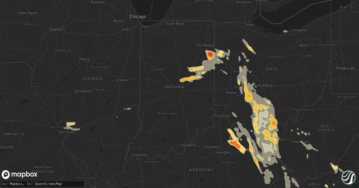
Hail Map in South Carolina on May 10, 2011
Get this storm
May 10 map
$229
one time, instant access
Download today. No call, no setup
Keep the $229
Bought the map and want the full workflow? Apply the entire $229 to a subscription within 7 days. None of it is wasted.
Every map, not just this one
This buys you this map. Subscription and you get every map we run, in the markets you choose from a few cities to whole states to nationwide. Plus real-time alerts the moment a storm fires.
Contact data
Name, contact info, occupancy, even credit band for addresses in the footprint. You go from where it hit to who to call.
Become the source they trust
Unlimited branding weather history reports on demand. You already have the documented answer ready for the property owner, and you are the one who showed up with it.
Property data and RoofTrace estimates
Pull up any address you have got, its value and the exact code rules for that jurisdiction, straight from One Click Code. Then RoofTrace estimates the squares, pitch, and roof value, priced the way you price.
Storm reports in South Carolina
South Carolina
| Date | Description |
|---|---|
| 05/10/20116:55 PM CDT | A local report indicates 1.00 inch wind near FOUNTAIN INN |
| 05/10/20116:55 PM CDT | A local report indicates 1.75 inch wind near 1 S ANDREWS |
| 05/10/20116:45 PM CDT | There were several reports in this area of golf ball sized hail in the five forks area down to simpsonville. Hail started at 732 pm at this specific location and contin |
| 05/10/20116:45 PM CDT | A local report indicates 2.00 inch wind near 4 E MAULDIN |
| 05/10/20116:42 PM CDT | A local report indicates 1.75 inch wind near 5 ENE MAULDIN |
| 05/10/20116:40 PM CDT | A local report indicates 1.50 inch wind near 4 ENE MAULDIN |
| 05/10/20116:38 PM CDT | A local report indicates 1.00 inch wind near NESMITH |
| 05/10/20116:37 PM CDT | A local report indicates 1.75 inch wind near 3 E MAULDIN |
| 05/10/20116:32 PM CDT | A local report indicates 1.25 inch wind near 4 E MAULDIN |
| 05/10/20116:30 PM CDT | A local report indicates 2.50 inch wind near ANDREWS |
| 05/10/20116:29 PM CDT | Baseball size hail damaging vehicles in the area. |
| 05/10/20116:27 PM CDT | One inch hail |
| 05/10/20116:25 PM CDT | Cocorahs observer reports half dollar sized hail with shredded leaves and dents in their car. |
| 05/10/20116:20 PM CDT | A local report indicates 1.00 inch wind near 5 SW GREER |
| 05/10/20116:16 PM CDT | Golf ball hail at the boiling springs fire dept |
| 05/10/20116:14 PM CDT | A local report indicates 1.50 inch wind near 3 SSE NICHOLS |
| 05/10/20116:00 PM CDT | Cocorahs observer reports quarter to ping pong ball sized hail. |
| 05/10/20116:00 PM CDT | Baseball size hail damaged dozens of cars in the community of woodcreek. |
| 05/10/20116:00 PM CDT | A local report indicates 1.00 inch wind near 7 E CAMPOBELLO |
| 05/10/20116:00 PM CDT | Largest hail was the size of a quarter. Shredded leaves. |
| 05/10/20115:58 PM CDT | Nickel to golfball size hail in downtown conway |
| 05/10/20115:57 PM CDT | Media viewer report softball size hail at the walmart in conway |
| 05/10/20115:55 PM CDT | Wmbf viewer reports baseball size hail in north conway |
| 05/10/20115:55 PM CDT | Hail fell at wade hampton and watson roads. |
| 05/10/20115:55 PM CDT | Golfball to baseball size hail |
| 05/10/20115:50 PM CDT | Hail up to half dollar size at the waffle house. Fell from 650 to 711 pm. |
| 05/10/20115:47 PM CDT | Intersection of sandy flat rd and lynn rd |
| 05/10/20115:40 PM CDT | The large hail fell from 640 pm edt until 645 pm edt... And covered the ground. The hail caused damage to vehicles and homes near highway 501. |
| 05/10/20115:40 PM CDT | Hail covering the ground. The hail lasted from 640 pm edt until 647 pm edt |
| 05/10/20115:40 PM CDT | Hail covered the ground |
| 05/10/20115:40 PM CDT | A local report indicates 1.00 inch wind near 2 NE NESMITH |
| 05/10/20115:40 PM CDT | Off duty nws employee reports numerous dents in vehicles...lots of leaf debris...and several branches down from the hail. |
| 05/10/20115:35 PM CDT | Hail covering the ground. |
| 05/10/20115:33 PM CDT | Hail fell from 633 pm to 645 pm |
| 05/10/20115:30 PM CDT | A local report indicates 1.75 inch wind near JOHNSONVILLE |
| 05/10/20115:30 PM CDT | A local report indicates 1.00 inch wind near 6 E GRESHAM |
| 05/10/20115:27 PM CDT | A local report indicates 1.00 inch wind near 4 W JOHNSONVILLE |
| 05/10/20115:25 PM CDT | Softball size hail over hannah broke a car window |
| 05/10/20115:25 PM CDT | Cocorahs observer reports half dollar sized hail with shredded leaves and dents in their car. |
| 05/10/20115:05 PM CDT | A local report indicates 1.75 inch wind near PAMPLICO |
| 05/10/20114:56 PM CDT | A local report indicates 1.75 inch wind near PAMPLICO |
| 05/10/20114:55 PM CDT | Baseball size hail covering the ground. |
| 05/10/20114:50 PM CDT | Golfball to tennis ball size hail. Hail tore the gutters off the house and damaged a car. |
| 05/10/20114:34 PM CDT | A local report indicates 1.75 inch wind near NORTH MYRTLE BEACH |
| 05/10/20114:33 PM CDT | A local report indicates 1.00 inch wind near 4 NE EVERGREEN |
| 05/10/20114:29 PM CDT | Ping pong size hail on hwy 90 near the intersection of hwy 31. |
| 05/10/20114:26 PM CDT | A local report indicates 1.25 inch wind near LONGS |
| 05/10/20114:24 PM CDT | A local report indicates 1.00 inch wind near LITTLE RIVER |
| 05/10/20114:21 PM CDT | Nickel to quarter size hail. |
| 05/10/20114:15 PM CDT | A local report indicates 1.00 inch wind near LONGS |
| 05/10/20112:56 AM CDT | Ping pong ball size hail reported along the highway 78 highway 52 connector. |
| 05/10/20112:44 AM CDT | Time estimated based off radar |
| 05/10/20112:40 AM CDT | Powerpoll down blocking mccrae drive. |
| 05/10/20112:39 AM CDT | Tree down on n hazard street |
| 05/10/20112:39 AM CDT | Field of wheat about 2 ft high flattened. Time estimated based off radar. |
| 05/10/20112:25 AM CDT | A local report indicates 1.00 inch wind near 2 SSE BONNEAU |
| 05/10/20112:25 AM CDT | Time estimated based off radar |
| 05/10/20112:20 AM CDT | Large tree down blocking mudville road. |
| 05/10/20112:10 AM CDT | Sheriff reports trees down between summerton and manning on alex harvin road and also on hwy 261 west of manning. |
| 05/10/20112:08 AM CDT | Highway patrol reported trees down near the intersection of hwys 301 and 47 near elloree. |
| 05/10/20112:07 AM CDT | Time estimated based off radar |
| 05/10/20112:05 AM CDT | Trees down on mcgirt swamp rd. |
| 05/10/20112:02 AM CDT | Tree down along sc hwy 341 7 miles west of johnsonville. Time estimated based off radar. |
| 05/10/20111:53 AM CDT | Time estimated based off radar |
| 05/10/20111:53 AM CDT | Time estimated based off radar. |
| 05/10/20111:40 AM CDT | Sheriff reported trees down at hwy 378 and 261 and also along hwy 261 to wedgefield. |
| 05/10/20111:39 AM CDT | Tree down at 3600 south hill road. Time estimated based off radar. |
| 05/10/20111:23 AM CDT | Power pole blown down by the hospital. |
| 05/10/20111:20 AM CDT | Sheriff reported trees down in southeast richland county in the eastover area. |
| 05/10/20111:14 AM CDT | Shaw meteorologist reported 1 inch hail on hwy 378 just east of columbia. |
| 05/10/20111:12 AM CDT | Dispatch reported trees down from blythewood to dentsville. |
| 05/10/20111:10 AM CDT | Sheriff reported trees and powerlines down from elgin to lugoff/camden to bethune. |
| 05/10/20111:06 AM CDT | Sheriff reoprted powerlines down in luggoff and large hail of unknown size. |
| 05/10/20111:03 AM CDT | Hail was measured and reported by public near the sw corner of ft jackson off leesburg rd about 2 miles east of i-77 |
| 05/10/20111:03 AM CDT | Public reported large branches down in northeast columbia. |
| 05/10/201112:45 AM CDT | Public reported trees down in pomeria. |
| 05/10/201112:45 AM CDT | Sheriff reported trees down across northern kershaw county. |
| 05/10/201112:40 AM CDT | Em reports trees and powerlines down in heath springs. |
| 05/10/201112:39 AM CDT | Em reported trees down across northern fairfield county from white oak to mitford. |
| 05/10/201112:39 AM CDT | Em reports trees down in northern fairfield county from white oak to mitford. |
| 05/10/201112:35 AM CDT | Em reports trees and powerlines down in heath springs. |
| 05/10/201112:30 AM CDT | Sheriff reported trees down in the van wyck area. |
| 05/10/201112:30 AM CDT | Sheriff reported trees down in the van wyck area. |
| 05/10/201112:14 AM CDT | Public reported trees down in whitmire. |
| 05/10/201112:04 AM CDT | Large branches down. |
| 05/09/201111:58 PM CDT | Pk wnd 34054/0458 |
| 05/09/201111:53 PM CDT | Numerous trees down on lake wylie road near the lake. |
| 05/09/201111:50 PM CDT | Numerous trees down across the roadway near the intersection of evergreen road and riverfront road. |
| 05/09/201111:42 PM CDT | Jonesville fire department reports first strong gust hit in this area along the spartanburg highway at 1242 am blowing down trees. There were other locations around jon |
| 05/09/201111:40 PM CDT | Tree across the roadway at grandview road and hw-161. |
| 05/09/201111:40 PM CDT | Trees across the roadway at whitworth road and hw-161. |
| 05/09/201111:35 PM CDT | Numerous trees down from highway 18 at the state border with north carolina down to the ninety nine islands power plant. A resident in blacksburg had a large tree on hi |
| 05/09/201111:32 PM CDT | Trees down on powerlines at hw-18 and i-85. |
| 05/09/201111:27 PM CDT | Tree down on highway 5 at youngs grove rd. |
| 05/09/201111:27 PM CDT | Tree down on a house on front street. |
| 05/09/201111:25 PM CDT | Large branches broken. |
| 05/09/201111:23 PM CDT | Multiple trees and powerlines down near the intersection of bridges road and hw-5. |
| 05/09/201111:22 PM CDT | Tree down. |
| 05/09/20119:43 PM CDT | Isle of palms fire dept number 1 receiving golf ball size hail. |
| 05/09/20119:41 PM CDT | Public report of golf ball size hail from wild dunes. |
| 05/09/20118:52 PM CDT | Golf ball size hail. Time estimated via radar. |
| 05/09/20118:18 PM CDT | Report of golf ball to softball size hail along st. Delight rd |
| 05/09/20118:08 PM CDT | Quarter size hail occurred along highway 501 east southeast of andrews. |
| 05/09/20117:54 PM CDT | Golf ball size hail reported on us-17n between awendaw and mcclellanville. |
| 05/09/20117:43 PM CDT | Golf ball size hail has been falling for a few minutes. |
| 05/09/20117:36 PM CDT | A local report indicates 1.00 inch wind near NESMITH |
| 05/09/20117:35 PM CDT | Quarter size hail reported at the exxon station in rhems. |
| 05/09/20117:27 PM CDT | Hail fell for 7 minutes. Covered the ground. |
| 05/09/20117:05 PM CDT | Hw-14 quick stop rerported hail up to the size of quarters. |
All States Impacted by Hail Map on May 10, 2011
Cities Impacted by Hail Map on May 10, 2011
- Pease, MN
- Princeton, MN
- Foreston, MN
- Milaca, MN
- Berne, IN
- Ossian, IN
- Bluffton, IN
- Decatur, IN
- Monroe, IN
- Stone Lake, WI
- Hayward, WI
- Marine On Saint Croix, MN
- Hugo, MN
- Forest Lake, MN
- Scandia, MN
- Pamplico, SC
- Wabeno, WI
- White Lake, WI
- Concord, NC
- Charlotte, NC
- Huntersville, NC
- Harrisburg, NC
- Orrum, NC
- Fairmont, NC
- Hopkins, SC
- Columbia, SC
- Keystone, IN
- Andrews, SC
- Georgetown, SC
- Little River, SC
- Longs, SC
- Conway, SC
- Myrtle Beach, SC
- North Myrtle Beach, SC
- Loris, SC
- South Charleston, OH
- Thelma, KY
- Londonderry, OH
- Stoutsville, OH
- Greenfield, OH
- West Portsmouth, OH
- Williamsport, KY
- Salt Lick, KY
- Brooksville, KY
- Tollesboro, KY
- Circleville, OH
- Salyersville, KY
- Waverly, OH
- Mount Olivet, KY
- Tomahawk, KY
- Pilgrim, KY
- Wilsondale, WV
- Clarksburg, OH
- Adams, KY
- Coalton, OH
- Garrison, KY
- Sandy Hook, KY
- Patriot, OH
- River, KY
- Isonville, KY
- South Webster, OH
- Wallingford, KY
- Georgetown, OH
- Ulysses, KY
- Boons Camp, KY
- East Liberty, OH
- West Jefferson, OH
- Bloomingburg, OH
- Friendship, OH
- Latham, OH
- McArthur, OH
- New Holland, OH
- Morehead, KY
- Martha, KY
- Oil Springs, KY
- Warfield, KY
- Mayslick, KY
- Laurelville, OH
- Elkfork, KY
- Plain City, OH
- Clearfield, KY
- Cable, OH
- Lucasville, OH
- Aberdeen, OH
- Crum, WV
- Russellville, OH
- Blaine, KY
- Oak Hill, OH
- Beaver, OH
- Ironton, OH
- South Bloomingville, OH
- Royalton, KY
- Jackson, OH
- North Lewisburg, OH
- Inez, KY
- Sabina, OH
- Willow Wood, OH
- Russell, KY
- Emerson, KY
- Rushsylvania, OH
- Jamestown, OH
- Wellston, OH
- Prestonsburg, KY
- West Van Lear, KY
- Ceredo, WV
- Vanceburg, KY
- Belle Center, OH
- Mingo, OH
- Manchester, OH
- Huntsville, OH
- Prichard, WV
- Lowmansville, KY
- West Liberty, KY
- Rush, KY
- Mize, KY
- Campton, KY
- Flatwoods, KY
- Wellington, KY
- Urbana, OH
- Ripley, OH
- Wheelersburg, OH
- Chesapeake, OH
- Bellefontaine, OH
- Clayhole, KY
- Pedro, OH
- Vest, KY
- East Point, KY
- Blue Creek, OH
- Wittensville, KY
- Augusta, KY
- Kingston, OH
- West Union, OH
- London, OH
- Springfield, OH
- Dover, KY
- Genoa, WV
- Van Lear, KY
- Russells Point, OH
- Auxier, KY
- Ashland, KY
- Hitchins, KY
- Worthington, KY
- Debord, KY
- Kermit, WV
- New Carlisle, OH
- Washington Court House, OH
- Hagerhill, KY
- Franklin Furnace, OH
- West Liberty, OH
- Frankfort, OH
- Blue River, KY
- South Salem, OH
- Ray, OH
- Tremont City, OH
- Waterloo, OH
- Mount Sterling, OH
- Denton, KY
- Catlettsburg, KY
- Saint Paris, OH
- Minford, OH
- Flatgap, KY
- Jeffersonville, OH
- Olive Hill, KY
- Grayson, KY
- Cedarville, OH
- Huntington, WV
- Quincy, KY
- Catawba, OH
- Stambaugh, KY
- Thurman, OH
- Hamersville, OH
- Lavalette, WV
- Tutor Key, KY
- Fort Gay, WV
- Mechanicsburg, OH
- Wayne, WV
- Cannel City, KY
- Argillite, KY
- Louisa, KY
- Hillsboro, OH
- Adelphi, OH
- Rousseau, KY
- Kitts Hill, OH
- South Shore, KY
- Lakeview, OH
- Zanesfield, OH
- Staffordsville, KY
- Piketon, OH
- Portsmouth, OH
- Flemingsburg, KY
- Ezel, KY
- South Point, OH
- Hazel Green, KY
- Ewing, KY
- McDermott, OH
- South Solon, OH
- Lewistown, OH
- Kenova, WV
- Peebles, OH
- South Portsmouth, KY
- Paintsville, KY
- Yellow Springs, OH
- Vancleve, KY
- Chillicothe, OH
- South Vienna, OH
- West Mansfield, OH
- Jackson, KY
- Dunlow, WV
- Williamsport, OH
- Greenup, KY
- Germantown, KY
- Meally, KY
- Rarden, OH
- Bainbridge, OH
- Sitka, KY
- Stout, OH
- Richmond Dale, OH
- De Graff, OH
- Keaton, KY
- Maysville, KY
- Otway, OH
- Charleston, WV
- Kimberly, WV
- Mount Carbon, WV
- Kanawha Falls, WV
- Hugheston, WV
- Pond Gap, WV
- Hico, WV
- Belva, WV
- Cedar Grove, WV
- Glasgow, WV
- Lansing, WV
- Ansted, WV
- Handley, WV
- Fayetteville, WV
- Smithers, WV
- Gallagher, WV
- East Bank, WV
- Mammoth, WV
- Montgomery, WV
- Victor, WV
- Drybranch, WV
- London, WV
- Belle, WV
- Pratt, WV
- Hansford, WV
- Powellton, WV
- Gauley Bridge, WV
- Blount, WV
- Moorefield, KY
- Falmouth, KY
- Sharpsburg, KY
- Mount Sterling, KY
- Cynthiana, KY
- Millersburg, KY
- Paris, KY
- Olympia, KY
- Owingsville, KY
- Foster, KY
- Carlisle, KY
- Oak Park, MN
- Lugoff, SC
- Mooresville, NC
- Charleston, SC
- Mount Pleasant, SC
- Sullivans Island, SC
- Saint Croix Falls, WI
- Grantsburg, WI
- North Branch, MN
- Harris, MN
- Aynor, SC
- Galivants Ferry, SC
- Nichols, SC
- Foley, MN
- Effingham, SC
- Lake City, SC
- Johnsonville, SC
- Florence, SC
- Hemingway, SC
- Dugspur, VA
- Laurel Fork, VA
- Hillsville, VA
- Summitville, IN
- Fowlerton, IN
- Jonesboro, IN
- Fairmount, IN
- Chanhassen, MN
- Eden Prairie, MN
- Chaska, MN
- Clarkton, NC
- Whiteville, NC
- Bladenboro, NC
- Alton, IL
- Hartford, IL
- Moro, IL
- Wood River, IL
- West Alton, MO
- East Alton, IL
- South Roxana, IL
- Roxana, IL
- Saint Louis, MO
- Cottage Hills, IL
- Bethalto, IL
- Edwardsville, IL
- Southport, NC
- Bolivia, NC
- Kure Beach, NC
- Winnabow, NC
- Evergreen, NC
- Hallsboro, NC
- Perryton, TX
- Cicero, IN
- Noblesville, IN
- Arcadia, IN
- Frankton, IN
- Anderson, IN
- Simpsonville, SC
- Fountain Inn, SC
- Greenville, SC
- Van Wert, OH
- Travelers Rest, SC
- Mullins, SC
- Gresham, SC
- Marion, SC
- Green Sea, SC
- Fair Bluff, NC
- Jamestown, SC
- Arcadia, OH
- Alvada, OH
- Findlay, OH
- Vanlue, OH
- Carey, OH
- Mount Blanchard, OH
- Pulaski, VA
- Dublin, VA
- Claudville, VA
- Willis, VA
- Ararat, VA
- Masterson, TX
- Batavia, OH
- Goshen, OH
- Williamsburg, OH
- Gaston, IN
- Matthews, IN
- Eaton, IN
- Dunkirk, IN
- Upland, IN
- Hartford City, IN
- Gas City, IN
- Pennville, IN
- Montpelier, IN
- Muncie, IN
- Rock, KS
- Winfield, KS
- Awendaw, SC
- Isle Of Palms, SC
- Daleville, IN
- Yorktown, IN
- Alexandria, IN
- Trego, WI
- Spooner, WI
- Paint Bank, VA
- Troutville, VA
- New Castle, VA
- Liberty, WV
- Quail, TX
- Hedley, TX
- Atlanta, IN
- Rush City, MN
- Stanchfield, MN
- Braham, MN
- Cambridge, MN
- Pender, NE
- Wisner, NE
- Bancroft, NE
- Maria Stein, OH
- Saint Henry, OH
- Minnetonka, MN
- Hopkins, MN
- Minneapolis, MN
- Shakopee, MN
- Seagraves, TX
- Hamer, SC
- Rowland, NC
- Anoka, MN
- Elk River, MN
- Isanti, MN
- Saint Francis, MN
- Valdese, NC
- Connelly Springs, NC
- Drexel, NC
- Lawndale, NC
- Hickory, NC
- Morganton, NC
- Vale, NC
- Hildebran, NC
- Raymond, OH
- Marysville, OH
- Davidson, NC
- Siren, WI
- Webster, WI
- Saint Michael, MN
- Monticello, MN
- Albertville, MN
- Rogers, MN
- Yorkshire, OH
- Houston, OH
- Fort Loramie, OH
- McClellanville, SC
- Nesmith, SC
- Scranton, SC
- Shelby, NC
- Union Mills, NC
- Ellenboro, NC
- Forest City, NC
- Chesnee, SC
- Nebo, NC
- Mooresboro, NC
- Spindale, NC
- Bostic, NC
- Marion, NC
- Rutherfordton, NC
- Gaffney, SC
- Casar, NC
- Duncan, SC
- Wellford, SC
- Startex, SC
- Greer, SC
- Lyman, SC
- Plains, TX
- Squaw Lake, MN
- Northome, MN
- Radford, VA
- Harrod, OH
- Ada, OH
- Alger, OH
- Mora, MN
- Lorenzo, TX
- Floydada, TX
- Petersburg, TX
- Idalou, TX
- Silverton, TX
- Kress, TX
- Lockney, TX
- Happy, TX
- Tulia, TX
- Hope, KY
- Means, KY
- Taylors, SC
- Bowlus, MN
- Royalton, MN
- Pine City, MN
- Grasston, MN
- Quemado, TX
- Oakwood, VA
- Richlands, VA
- Bandy, VA
- Whitewood, VA
- Grundy, VA
- Cedar Bluff, VA
- Raven, VA
- Pilgrims Knob, VA
- Pounding Mill, VA
- Jewell Ridge, VA
- Springbrook, WI
- Frederic, WI
- Shell Lake, WI
- Ely, MN
- Union, WV
- Sinks Grove, WV
- Gap Mills, WV
- Secondcreekx, WV
- Excelsior, MN
- Saint Paul, MN
- Redkey, IN
- Ridgeville, IN
- Albany, IN
- Ronceverte, WV
- Waiteville, WV
- Pelican Lake, WI
- Rhinelander, WI
- Indian Valley, VA
- Fancy Gap, VA
- Meadows Of Dan, VA
- Mount Airy, NC
- Lumberton, NC
- Tabor City, NC
- Troutman, NC
- Dalbo, MN
- Sauk Rapids, MN
- Dieterich, IL
- Wheeler, IL
- Hi Hat, KY
- Raven, KY
- Jeremiah, KY
- Roxana, KY
- Beaver, KY
- Virgie, KY
- Millstone, KY
- McDowell, KY
- Thornton, KY
- Littcarr, KY
- Premium, KY
- Langley, KY
- Kite, KY
- Vicco, KY
- Grethel, KY
- Hindman, KY
- Ermine, KY
- Melvin, KY
- Whitesburg, KY
- Hueysville, KY
- Minnie, KY
- Topmost, KY
- Isom, KY
- Drift, KY
- Redfox, KY
- Mallie, KY
- Pine Top, KY
- Garrett, KY
- Pippa Passes, KY
- Bevinsville, KY
- Deane, KY
- Weeksbury, KY
- Wayland, KY
- Wheelwright, KY
- Blackey, KY
- Bypro, KY
- Mousie, KY
- Dema, KY
- Leburn, KY
- Garner, KY
- Lackey, KY
- Gunlock, KY
- Eastern, KY
- Booker, TX
- Balko, OK
- Dillon, SC
- Crivitz, WI
- Athelstane, WI
- Wausaukee, WI
- Walton, WV
- Clendenin, WV
- Amma, WV
- Hiwassee, VA
- Blooming Prairie, MN
- Ellendale, MN
- Riner, VA
- Christiansburg, VA
- Kings Mountain, NC
- Clover, SC
- Gastonia, NC
- Mount Ulla, NC
- China Grove, NC
- Cleveland, NC
- Ohio City, OH
- Middle Point, OH
- Campobello, SC
- Inman, SC
- Landrum, SC
- Greeneville, TN
- Chuckey, TN
- Afton, TN
- Monroe, NC
- Midland, NC
- Statesville, NC
- Kannapolis, NC
- Matthews, NC
- Cornelius, NC
- Indian Trail, NC
- Pineville, NC
- Saint Germain, WI
- Lac Du Flambeau, WI
- Minocqua, WI
- Woodruff, WI
- Boulder Junction, WI
- Sayner, WI
- Ogilvie, MN
- Eastover, SC
- Maxton, NC
- Frenchburg, KY
- Luck, WI
- Cushing, WI
- Lake View, SC
- Van Buren, OH
- Bloomdale, OH
- Wharton, OH
- McComb, OH
- Upper Sandusky, OH
- Custar, OH
- Cygnet, OH
- North Baltimore, OH
- Saint Matthews, SC
- Cameron, SC
- Hanahan, SC
- North Charleston, SC
- Goose Creek, SC
- Ladson, SC
- Advent, WV
- Kenna, WV
- Southside, WV
- Leon, WV
- Nakina, NC
- Spencerville, OH
- Lima, OH
- Loop, TX
- Brownfield, TX
- Claude, TX
- Beckley, WV
- Artie, WV
- Whitesville, WV
- Clear Creek, WV
- Eskdale, WV
- Iron River, MI
- Watersmeet, MI
- Crystal Falls, MI
- Trout Creek, MI
- Calabash, NC
- Sunset Beach, NC
- Vansant, VA
- Lebanon, VA
- Fedscreek, KY
- Rowe, VA
- Kimper, KY
- Hurley, VA
- Davenport, VA
- Cleveland, VA
- Phelps, KY
- Steele, KY
- Big Rock, VA
- Haysi, VA
- Bee, VA
- Honaker, VA
- Lubbock, TX
- Wolfforth, TX
- Given, WV
- Rockford, OH
- Hertel, WI
- Glen Carbon, IL
- Granite City, IL
- Highland, IL
- Saint Jacob, IL
- Maryville, IL
- Collinsville, IL
- Florissant, MO
- Troy, IL
- Wellington, TX
- Shamrock, TX
- Babbitt, MN
- Hereford, TX
- Church Hill, TN
- Duffield, VA
- Eidson, TN
- Surgoinsville, TN
- Gate City, VA
- Blacksburg, SC
- Grover, NC
- Greenup, IL
- Casey, IL
- Hardy, KY
- Belfry, KY
- Pinsonfork, KY
- Ransom, KY
- Canada, KY
- Stone, KY
- Huddy, KY
- Forest Hills, KY
- McAndrews, KY
- Center City, MN
- Buffalo, MN
- Sarona, WI
- Lindstrom, MN
- Grandy, MN
- Cedar, MN
- Stacy, MN
- Bethel, MN
- Heath Springs, SC
- Lancaster, SC
- Bruce Crossing, MI
- Ada, OK
- Woolwine, VA
- Pineville, SC
- Bonneau, SC
- Moncks Corner, SC
- Tahoka, TX
- Meadow, TX
- Gruver, TX
- Groom, TX
- Coward, SC
- Lane, SC
- Longwood, NC
- Timmonsville, SC
- Fork, SC
- Cordesville, SC
- Leland, NC
- Huger, SC
- Salters, SC
- Lake Waccamaw, NC
- Bolton, NC
- Murrells Inlet, SC
- Ocean Isle Beach, NC
- Chadbourn, NC
- Charleston Afb, SC
- Ridgeville, SC
- Folly Beach, SC
- Supply, NC
- Summerville, SC
- Ash, NC
- Cerro Gordo, NC
- Clarendon, NC
- Cades, SC
- Kingstree, SC
- Pembroke, NC
- Floyd, VA
- Catawba, VA
- Hillman, MN
- Bock, MN
- Clear Lake, MN
- Pierz, MN
- Rice, MN
- Saint Cloud, MN
- Lena, WI
- Suring, WI
- Gillett, WI
- Oconto Falls, WI
- Webbville, KY
- Gadsden, SC
- Elgin, SC
- Winnsboro, SC
- Ridgeway, SC
- Blythewood, SC
- Lovington, NM
- Hobbs, NM
- Morton, TX
- Whiteface, TX
- Littlefield, TX
- Levelland, TX
- Denver City, TX
- Seminole, TX
- Monroeville, IN
- Swayzee, IN
- Fort Wayne, IN
- Hoagland, IN
- Farmland, IN
- Venedocia, OH
- Cloverdale, OH
- Parker City, IN
- Fort Jennings, OH
- Selma, IN
- Willshire, OH
- Delphos, OH
- Craigville, IN
- Poneto, IN
- Marion, IN
- Convoy, OH
- Lapel, IN
- Portland, IN
- Bryant, IN
- Mendon, OH
- Geneva, IN
- Wren, OH
- Petroleum, IN
- Fort Recovery, OH
- Celina, OH
- Chassell, MI
- Wellston, OK
- Coyle, OK
- Meridian, OK
- Perkins, OK
- Cramerton, NC
- Lowell, NC
- Belmont, NC
- Ravenel, SC
- Sheffield Lake, OH
- Lorain, OH
- Cherryville, NC
- Stinnett, TX
- White Deer, TX
- Borger, TX
- Panhandle, TX
- Elkview, WV
- Bluffton, OH
- Jenera, OH
- Dola, OH
- Kenton, OH
- Dunkirk, OH
- Forest, OH
- Mauldin, SC
- Gray Court, SC
- Prior Lake, MN
- Wayzata, MN
- New Prague, MN
- Savage, MN
- Jordan, MN
- Martinsville, IL


