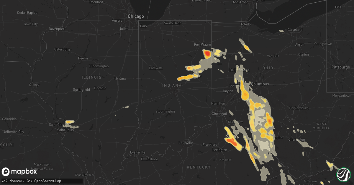
Hail Map in Minnesota on May 10, 2011
Get this storm
May 10 map
$229
one time, instant access
Download today. No call, no setup
Keep the $229
Bought the map and want the full workflow? Apply the entire $229 to a subscription within 7 days. None of it is wasted.
Every map, not just this one
This buys you this map. Subscription and you get every map we run, in the markets you choose from a few cities to whole states to nationwide. Plus real-time alerts the moment a storm fires.
Contact data
Name, contact info, occupancy, even credit band for addresses in the footprint. You go from where it hit to who to call.
Become the source they trust
Unlimited branding weather history reports on demand. You already have the documented answer ready for the property owner, and you are the one who showed up with it.
Property data and RoofTrace estimates
Pull up any address you have got, its value and the exact code rules for that jurisdiction, straight from One Click Code. Then RoofTrace estimates the squares, pitch, and roof value, priced the way you price.
Storm reports in Minnesota
Minnesota
| Date | Description |
|---|---|
| 05/10/20116:44 PM CDT | A local report indicates 1.25 inch wind near ST JOSEPH |
| 05/10/20116:43 PM CDT | A local report indicates 1.75 inch wind near 1 N ST JOSEPH |
| 05/10/20116:38 PM CDT | A local report indicates 1.25 inch wind near 1 S BOWLUS |
| 05/10/20116:30 PM CDT | A local report indicates 1.00 inch wind near 1 ESE ST JOSEPH |
| 05/09/201111:39 PM CDT | Delayed report. Mostly small hail but a few minutes of some quarter size hail. Nearly constant lightning. On moose lake. |
| 05/09/201110:50 PM CDT | A local report indicates 1.50 inch wind near 2 NE NORTH BRANCH |
| 05/09/20119:15 PM CDT | A local report indicates 2.00 inch wind near 2 E PEASE |
| 05/09/20119:04 PM CDT | A local report indicates 1.00 inch wind near 3 NE ELK RIVER |
| 05/09/20119:00 PM CDT | A local report indicates 1.75 inch wind near ST FRANCIS |
| 05/09/20118:50 PM CDT | Target field |
| 05/09/20118:40 PM CDT | A local report indicates 1.75 inch wind near ST LOUIS PARK |
| 05/09/20118:39 PM CDT | A local report indicates 2.00 inch wind near 1 NW MINNEAPOLIS |
| 05/09/20118:37 PM CDT | At intersection of 100th st and 125th ave. |
| 05/09/20118:35 PM CDT | A local report indicates 1.75 inch wind near 2 N ST LOUIS PARK |
| 05/09/20118:35 PM CDT | Broadway and interstate 94 |
| 05/09/20118:35 PM CDT | A local report indicates 2.00 inch wind near 3 SSW FOREST LAKE |
| 05/09/20118:34 PM CDT | A local report indicates 2.00 inch wind near 4 SSW FORESTON |
| 05/09/20118:33 PM CDT | Broadway and interstate 94 |
| 05/09/20118:30 PM CDT | A local report indicates 2.50 inch wind near ST LOUIS PARK |
| 05/09/20118:29 PM CDT | Reported at corner of franklin and lyndale. |
| 05/09/20118:28 PM CDT | A local report indicates 1.75 inch wind near 5 WSW MINNEAPOLIS |
| 05/09/20118:28 PM CDT | At intersection of 394 and louisiana ave. |
| 05/09/20118:25 PM CDT | A local report indicates 1.00 inch wind near ELK RIVER |
| 05/09/20118:24 PM CDT | A local report indicates 1.75 inch wind near ELK RIVER |
| 05/09/20118:21 PM CDT | A local report indicates 2.00 inch wind near OAK PARK |
| 05/09/20118:19 PM CDT | A local report indicates 2.75 inch wind near ALBERTVILLE |
| 05/09/20118:15 PM CDT | A local report indicates 2.00 inch wind near 3 NE EDEN PRAIRIE |
| 05/09/20118:15 PM CDT | A local report indicates 2.00 inch wind near ALBERTVILLE |
| 05/09/20118:15 PM CDT | A local report indicates 1.75 inch wind near EDINA |
| 05/09/20118:13 PM CDT | A local report indicates 1.00 inch wind near EDEN PRAIRIE |
| 05/09/20118:10 PM CDT | A local report indicates 1.00 inch wind near 2 W ELK RIVER |
| 05/09/20118:10 PM CDT | A local report indicates 1.00 inch wind near EDINA |
| 05/09/20118:08 PM CDT | A local report indicates 1.00 inch wind near EDINA |
| 05/09/20118:05 PM CDT | A local report indicates 1.25 inch wind near 1 SSW EDEN PRAIRIE |
| 05/09/20118:03 PM CDT | A local report indicates 1.25 inch wind near EDINA |
| 05/09/20118:03 PM CDT | A local report indicates 1.75 inch wind near 1 ENE EDEN PRAIRIE |
| 05/09/20117:59 PM CDT | Debris visible cr 118 and cr 35 |
| 05/09/20117:58 PM CDT | Time estimated. Roof of a home damaged on 42nd st ne. |
| 05/09/20117:58 PM CDT | A local report indicates 2.00 inch wind near RONNEBY |
| 05/09/20117:58 PM CDT | A local report indicates 1.00 inch wind near 5 WSW EDEN PRAIRIE |
| 05/09/20117:58 PM CDT | A local report indicates 1.00 inch wind near ST MICHAEL |
| 05/09/20117:55 PM CDT | A local report indicates 1.00 inch wind near EDEN PRAIRIE |
| 05/09/20117:54 PM CDT | An nws storm survey assessed an ef-1 tornado with maximum winds near 90 mph tracked for approximately three miles to the northeast ending one mile west of st. Michael. |
| 05/09/20117:48 PM CDT | At weather office |
| 05/09/20117:43 PM CDT | A local report indicates 1.75 inch wind near 3 W ST MICHAEL |
| 05/09/20117:43 PM CDT | A local report indicates 1.00 inch wind near FOLEY |
| 05/09/20117:43 PM CDT | A local report indicates 1.00 inch wind near 1 SSW FOLEY |
| 05/09/20117:43 PM CDT | A local report indicates 1.75 inch wind near CHASKA |
| 05/09/20117:41 PM CDT | A local report indicates 1.00 inch wind near WAITE PARK |
| 05/09/20117:40 PM CDT | A local report indicates 1.00 inch wind near CHASKA |
| 05/09/20117:37 PM CDT | A local report indicates 1.00 inch wind near 1 WNW FOLEY |
| 05/09/20117:20 PM CDT | A local report indicates 1.00 inch wind near BUFFALO |
| 05/09/20117:13 PM CDT | A local report indicates 1.00 inch wind near 1 ENE ELLENDALE |
All States Impacted by Hail Map on May 10, 2011
Cities Impacted by Hail Map on May 10, 2011
- Pease, MN
- Princeton, MN
- Foreston, MN
- Milaca, MN
- Berne, IN
- Ossian, IN
- Bluffton, IN
- Decatur, IN
- Monroe, IN
- Stone Lake, WI
- Hayward, WI
- Marine On Saint Croix, MN
- Hugo, MN
- Forest Lake, MN
- Scandia, MN
- Pamplico, SC
- Wabeno, WI
- White Lake, WI
- Concord, NC
- Charlotte, NC
- Huntersville, NC
- Harrisburg, NC
- Orrum, NC
- Fairmont, NC
- Hopkins, SC
- Columbia, SC
- Keystone, IN
- Andrews, SC
- Georgetown, SC
- Little River, SC
- Longs, SC
- Conway, SC
- Myrtle Beach, SC
- North Myrtle Beach, SC
- Loris, SC
- South Charleston, OH
- Thelma, KY
- Londonderry, OH
- Stoutsville, OH
- Greenfield, OH
- West Portsmouth, OH
- Williamsport, KY
- Salt Lick, KY
- Brooksville, KY
- Tollesboro, KY
- Circleville, OH
- Salyersville, KY
- Waverly, OH
- Mount Olivet, KY
- Tomahawk, KY
- Pilgrim, KY
- Wilsondale, WV
- Clarksburg, OH
- Adams, KY
- Coalton, OH
- Garrison, KY
- Sandy Hook, KY
- Patriot, OH
- River, KY
- Isonville, KY
- South Webster, OH
- Wallingford, KY
- Georgetown, OH
- Ulysses, KY
- Boons Camp, KY
- East Liberty, OH
- West Jefferson, OH
- Bloomingburg, OH
- Friendship, OH
- Latham, OH
- McArthur, OH
- New Holland, OH
- Morehead, KY
- Martha, KY
- Oil Springs, KY
- Warfield, KY
- Mayslick, KY
- Laurelville, OH
- Elkfork, KY
- Plain City, OH
- Clearfield, KY
- Cable, OH
- Lucasville, OH
- Aberdeen, OH
- Crum, WV
- Russellville, OH
- Blaine, KY
- Oak Hill, OH
- Beaver, OH
- Ironton, OH
- South Bloomingville, OH
- Royalton, KY
- Jackson, OH
- North Lewisburg, OH
- Inez, KY
- Sabina, OH
- Willow Wood, OH
- Russell, KY
- Emerson, KY
- Rushsylvania, OH
- Jamestown, OH
- Wellston, OH
- Prestonsburg, KY
- West Van Lear, KY
- Ceredo, WV
- Vanceburg, KY
- Belle Center, OH
- Mingo, OH
- Manchester, OH
- Huntsville, OH
- Prichard, WV
- Lowmansville, KY
- West Liberty, KY
- Rush, KY
- Mize, KY
- Campton, KY
- Flatwoods, KY
- Wellington, KY
- Urbana, OH
- Ripley, OH
- Wheelersburg, OH
- Chesapeake, OH
- Bellefontaine, OH
- Clayhole, KY
- Pedro, OH
- Vest, KY
- East Point, KY
- Blue Creek, OH
- Wittensville, KY
- Augusta, KY
- Kingston, OH
- West Union, OH
- London, OH
- Springfield, OH
- Dover, KY
- Genoa, WV
- Van Lear, KY
- Russells Point, OH
- Auxier, KY
- Ashland, KY
- Hitchins, KY
- Worthington, KY
- Debord, KY
- Kermit, WV
- New Carlisle, OH
- Washington Court House, OH
- Hagerhill, KY
- Franklin Furnace, OH
- West Liberty, OH
- Frankfort, OH
- Blue River, KY
- South Salem, OH
- Ray, OH
- Tremont City, OH
- Waterloo, OH
- Mount Sterling, OH
- Denton, KY
- Catlettsburg, KY
- Saint Paris, OH
- Minford, OH
- Flatgap, KY
- Jeffersonville, OH
- Olive Hill, KY
- Grayson, KY
- Cedarville, OH
- Huntington, WV
- Quincy, KY
- Catawba, OH
- Stambaugh, KY
- Thurman, OH
- Hamersville, OH
- Lavalette, WV
- Tutor Key, KY
- Fort Gay, WV
- Mechanicsburg, OH
- Wayne, WV
- Cannel City, KY
- Argillite, KY
- Louisa, KY
- Hillsboro, OH
- Adelphi, OH
- Rousseau, KY
- Kitts Hill, OH
- South Shore, KY
- Lakeview, OH
- Zanesfield, OH
- Staffordsville, KY
- Piketon, OH
- Portsmouth, OH
- Flemingsburg, KY
- Ezel, KY
- South Point, OH
- Hazel Green, KY
- Ewing, KY
- McDermott, OH
- South Solon, OH
- Lewistown, OH
- Kenova, WV
- Peebles, OH
- South Portsmouth, KY
- Paintsville, KY
- Yellow Springs, OH
- Vancleve, KY
- Chillicothe, OH
- South Vienna, OH
- West Mansfield, OH
- Jackson, KY
- Dunlow, WV
- Williamsport, OH
- Greenup, KY
- Germantown, KY
- Meally, KY
- Rarden, OH
- Bainbridge, OH
- Sitka, KY
- Stout, OH
- Richmond Dale, OH
- De Graff, OH
- Keaton, KY
- Maysville, KY
- Otway, OH
- Charleston, WV
- Kimberly, WV
- Mount Carbon, WV
- Kanawha Falls, WV
- Hugheston, WV
- Pond Gap, WV
- Hico, WV
- Belva, WV
- Cedar Grove, WV
- Glasgow, WV
- Lansing, WV
- Ansted, WV
- Handley, WV
- Fayetteville, WV
- Smithers, WV
- Gallagher, WV
- East Bank, WV
- Mammoth, WV
- Montgomery, WV
- Victor, WV
- Drybranch, WV
- London, WV
- Belle, WV
- Pratt, WV
- Hansford, WV
- Powellton, WV
- Gauley Bridge, WV
- Blount, WV
- Moorefield, KY
- Falmouth, KY
- Sharpsburg, KY
- Mount Sterling, KY
- Cynthiana, KY
- Millersburg, KY
- Paris, KY
- Olympia, KY
- Owingsville, KY
- Foster, KY
- Carlisle, KY
- Oak Park, MN
- Lugoff, SC
- Mooresville, NC
- Charleston, SC
- Mount Pleasant, SC
- Sullivans Island, SC
- Saint Croix Falls, WI
- Grantsburg, WI
- North Branch, MN
- Harris, MN
- Aynor, SC
- Galivants Ferry, SC
- Nichols, SC
- Foley, MN
- Effingham, SC
- Lake City, SC
- Johnsonville, SC
- Florence, SC
- Hemingway, SC
- Dugspur, VA
- Laurel Fork, VA
- Hillsville, VA
- Summitville, IN
- Fowlerton, IN
- Jonesboro, IN
- Fairmount, IN
- Chanhassen, MN
- Eden Prairie, MN
- Chaska, MN
- Clarkton, NC
- Whiteville, NC
- Bladenboro, NC
- Alton, IL
- Hartford, IL
- Moro, IL
- Wood River, IL
- West Alton, MO
- East Alton, IL
- South Roxana, IL
- Roxana, IL
- Saint Louis, MO
- Cottage Hills, IL
- Bethalto, IL
- Edwardsville, IL
- Southport, NC
- Bolivia, NC
- Kure Beach, NC
- Winnabow, NC
- Evergreen, NC
- Hallsboro, NC
- Perryton, TX
- Cicero, IN
- Noblesville, IN
- Arcadia, IN
- Frankton, IN
- Anderson, IN
- Simpsonville, SC
- Fountain Inn, SC
- Greenville, SC
- Van Wert, OH
- Travelers Rest, SC
- Mullins, SC
- Gresham, SC
- Marion, SC
- Green Sea, SC
- Fair Bluff, NC
- Jamestown, SC
- Arcadia, OH
- Alvada, OH
- Findlay, OH
- Vanlue, OH
- Carey, OH
- Mount Blanchard, OH
- Pulaski, VA
- Dublin, VA
- Claudville, VA
- Willis, VA
- Ararat, VA
- Masterson, TX
- Batavia, OH
- Goshen, OH
- Williamsburg, OH
- Gaston, IN
- Matthews, IN
- Eaton, IN
- Dunkirk, IN
- Upland, IN
- Hartford City, IN
- Gas City, IN
- Pennville, IN
- Montpelier, IN
- Muncie, IN
- Rock, KS
- Winfield, KS
- Awendaw, SC
- Isle Of Palms, SC
- Daleville, IN
- Yorktown, IN
- Alexandria, IN
- Trego, WI
- Spooner, WI
- Paint Bank, VA
- Troutville, VA
- New Castle, VA
- Liberty, WV
- Quail, TX
- Hedley, TX
- Atlanta, IN
- Rush City, MN
- Stanchfield, MN
- Braham, MN
- Cambridge, MN
- Pender, NE
- Wisner, NE
- Bancroft, NE
- Maria Stein, OH
- Saint Henry, OH
- Minnetonka, MN
- Hopkins, MN
- Minneapolis, MN
- Shakopee, MN
- Seagraves, TX
- Hamer, SC
- Rowland, NC
- Anoka, MN
- Elk River, MN
- Isanti, MN
- Saint Francis, MN
- Valdese, NC
- Connelly Springs, NC
- Drexel, NC
- Lawndale, NC
- Hickory, NC
- Morganton, NC
- Vale, NC
- Hildebran, NC
- Raymond, OH
- Marysville, OH
- Davidson, NC
- Siren, WI
- Webster, WI
- Saint Michael, MN
- Monticello, MN
- Albertville, MN
- Rogers, MN
- Yorkshire, OH
- Houston, OH
- Fort Loramie, OH
- McClellanville, SC
- Nesmith, SC
- Scranton, SC
- Shelby, NC
- Union Mills, NC
- Ellenboro, NC
- Forest City, NC
- Chesnee, SC
- Nebo, NC
- Mooresboro, NC
- Spindale, NC
- Bostic, NC
- Marion, NC
- Rutherfordton, NC
- Gaffney, SC
- Casar, NC
- Duncan, SC
- Wellford, SC
- Startex, SC
- Greer, SC
- Lyman, SC
- Plains, TX
- Squaw Lake, MN
- Northome, MN
- Radford, VA
- Harrod, OH
- Ada, OH
- Alger, OH
- Mora, MN
- Lorenzo, TX
- Floydada, TX
- Petersburg, TX
- Idalou, TX
- Silverton, TX
- Kress, TX
- Lockney, TX
- Happy, TX
- Tulia, TX
- Hope, KY
- Means, KY
- Taylors, SC
- Bowlus, MN
- Royalton, MN
- Pine City, MN
- Grasston, MN
- Quemado, TX
- Oakwood, VA
- Richlands, VA
- Bandy, VA
- Whitewood, VA
- Grundy, VA
- Cedar Bluff, VA
- Raven, VA
- Pilgrims Knob, VA
- Pounding Mill, VA
- Jewell Ridge, VA
- Springbrook, WI
- Frederic, WI
- Shell Lake, WI
- Ely, MN
- Union, WV
- Sinks Grove, WV
- Gap Mills, WV
- Secondcreekx, WV
- Excelsior, MN
- Saint Paul, MN
- Redkey, IN
- Ridgeville, IN
- Albany, IN
- Ronceverte, WV
- Waiteville, WV
- Pelican Lake, WI
- Rhinelander, WI
- Indian Valley, VA
- Fancy Gap, VA
- Meadows Of Dan, VA
- Mount Airy, NC
- Lumberton, NC
- Tabor City, NC
- Troutman, NC
- Dalbo, MN
- Sauk Rapids, MN
- Dieterich, IL
- Wheeler, IL
- Hi Hat, KY
- Raven, KY
- Jeremiah, KY
- Roxana, KY
- Beaver, KY
- Virgie, KY
- Millstone, KY
- McDowell, KY
- Thornton, KY
- Littcarr, KY
- Premium, KY
- Langley, KY
- Kite, KY
- Vicco, KY
- Grethel, KY
- Hindman, KY
- Ermine, KY
- Melvin, KY
- Whitesburg, KY
- Hueysville, KY
- Minnie, KY
- Topmost, KY
- Isom, KY
- Drift, KY
- Redfox, KY
- Mallie, KY
- Pine Top, KY
- Garrett, KY
- Pippa Passes, KY
- Bevinsville, KY
- Deane, KY
- Weeksbury, KY
- Wayland, KY
- Wheelwright, KY
- Blackey, KY
- Bypro, KY
- Mousie, KY
- Dema, KY
- Leburn, KY
- Garner, KY
- Lackey, KY
- Gunlock, KY
- Eastern, KY
- Booker, TX
- Balko, OK
- Dillon, SC
- Crivitz, WI
- Athelstane, WI
- Wausaukee, WI
- Walton, WV
- Clendenin, WV
- Amma, WV
- Hiwassee, VA
- Blooming Prairie, MN
- Ellendale, MN
- Riner, VA
- Christiansburg, VA
- Kings Mountain, NC
- Clover, SC
- Gastonia, NC
- Mount Ulla, NC
- China Grove, NC
- Cleveland, NC
- Ohio City, OH
- Middle Point, OH
- Campobello, SC
- Inman, SC
- Landrum, SC
- Greeneville, TN
- Chuckey, TN
- Afton, TN
- Monroe, NC
- Midland, NC
- Statesville, NC
- Kannapolis, NC
- Matthews, NC
- Cornelius, NC
- Indian Trail, NC
- Pineville, NC
- Saint Germain, WI
- Lac Du Flambeau, WI
- Minocqua, WI
- Woodruff, WI
- Boulder Junction, WI
- Sayner, WI
- Ogilvie, MN
- Eastover, SC
- Maxton, NC
- Frenchburg, KY
- Luck, WI
- Cushing, WI
- Lake View, SC
- Van Buren, OH
- Bloomdale, OH
- Wharton, OH
- McComb, OH
- Upper Sandusky, OH
- Custar, OH
- Cygnet, OH
- North Baltimore, OH
- Saint Matthews, SC
- Cameron, SC
- Hanahan, SC
- North Charleston, SC
- Goose Creek, SC
- Ladson, SC
- Advent, WV
- Kenna, WV
- Southside, WV
- Leon, WV
- Nakina, NC
- Spencerville, OH
- Lima, OH
- Loop, TX
- Brownfield, TX
- Claude, TX
- Beckley, WV
- Artie, WV
- Whitesville, WV
- Clear Creek, WV
- Eskdale, WV
- Iron River, MI
- Watersmeet, MI
- Crystal Falls, MI
- Trout Creek, MI
- Calabash, NC
- Sunset Beach, NC
- Vansant, VA
- Lebanon, VA
- Fedscreek, KY
- Rowe, VA
- Kimper, KY
- Hurley, VA
- Davenport, VA
- Cleveland, VA
- Phelps, KY
- Steele, KY
- Big Rock, VA
- Haysi, VA
- Bee, VA
- Honaker, VA
- Lubbock, TX
- Wolfforth, TX
- Given, WV
- Rockford, OH
- Hertel, WI
- Glen Carbon, IL
- Granite City, IL
- Highland, IL
- Saint Jacob, IL
- Maryville, IL
- Collinsville, IL
- Florissant, MO
- Troy, IL
- Wellington, TX
- Shamrock, TX
- Babbitt, MN
- Hereford, TX
- Church Hill, TN
- Duffield, VA
- Eidson, TN
- Surgoinsville, TN
- Gate City, VA
- Blacksburg, SC
- Grover, NC
- Greenup, IL
- Casey, IL
- Hardy, KY
- Belfry, KY
- Pinsonfork, KY
- Ransom, KY
- Canada, KY
- Stone, KY
- Huddy, KY
- Forest Hills, KY
- McAndrews, KY
- Center City, MN
- Buffalo, MN
- Sarona, WI
- Lindstrom, MN
- Grandy, MN
- Cedar, MN
- Stacy, MN
- Bethel, MN
- Heath Springs, SC
- Lancaster, SC
- Bruce Crossing, MI
- Ada, OK
- Woolwine, VA
- Pineville, SC
- Bonneau, SC
- Moncks Corner, SC
- Tahoka, TX
- Meadow, TX
- Gruver, TX
- Groom, TX
- Coward, SC
- Lane, SC
- Longwood, NC
- Timmonsville, SC
- Fork, SC
- Cordesville, SC
- Leland, NC
- Huger, SC
- Salters, SC
- Lake Waccamaw, NC
- Bolton, NC
- Murrells Inlet, SC
- Ocean Isle Beach, NC
- Chadbourn, NC
- Charleston Afb, SC
- Ridgeville, SC
- Folly Beach, SC
- Supply, NC
- Summerville, SC
- Ash, NC
- Cerro Gordo, NC
- Clarendon, NC
- Cades, SC
- Kingstree, SC
- Pembroke, NC
- Floyd, VA
- Catawba, VA
- Hillman, MN
- Bock, MN
- Clear Lake, MN
- Pierz, MN
- Rice, MN
- Saint Cloud, MN
- Lena, WI
- Suring, WI
- Gillett, WI
- Oconto Falls, WI
- Webbville, KY
- Gadsden, SC
- Elgin, SC
- Winnsboro, SC
- Ridgeway, SC
- Blythewood, SC
- Lovington, NM
- Hobbs, NM
- Morton, TX
- Whiteface, TX
- Littlefield, TX
- Levelland, TX
- Denver City, TX
- Seminole, TX
- Monroeville, IN
- Swayzee, IN
- Fort Wayne, IN
- Hoagland, IN
- Farmland, IN
- Venedocia, OH
- Cloverdale, OH
- Parker City, IN
- Fort Jennings, OH
- Selma, IN
- Willshire, OH
- Delphos, OH
- Craigville, IN
- Poneto, IN
- Marion, IN
- Convoy, OH
- Lapel, IN
- Portland, IN
- Bryant, IN
- Mendon, OH
- Geneva, IN
- Wren, OH
- Petroleum, IN
- Fort Recovery, OH
- Celina, OH
- Chassell, MI
- Wellston, OK
- Coyle, OK
- Meridian, OK
- Perkins, OK
- Cramerton, NC
- Lowell, NC
- Belmont, NC
- Ravenel, SC
- Sheffield Lake, OH
- Lorain, OH
- Cherryville, NC
- Stinnett, TX
- White Deer, TX
- Borger, TX
- Panhandle, TX
- Elkview, WV
- Bluffton, OH
- Jenera, OH
- Dola, OH
- Kenton, OH
- Dunkirk, OH
- Forest, OH
- Mauldin, SC
- Gray Court, SC
- Prior Lake, MN
- Wayzata, MN
- New Prague, MN
- Savage, MN
- Jordan, MN
- Martinsville, IL


