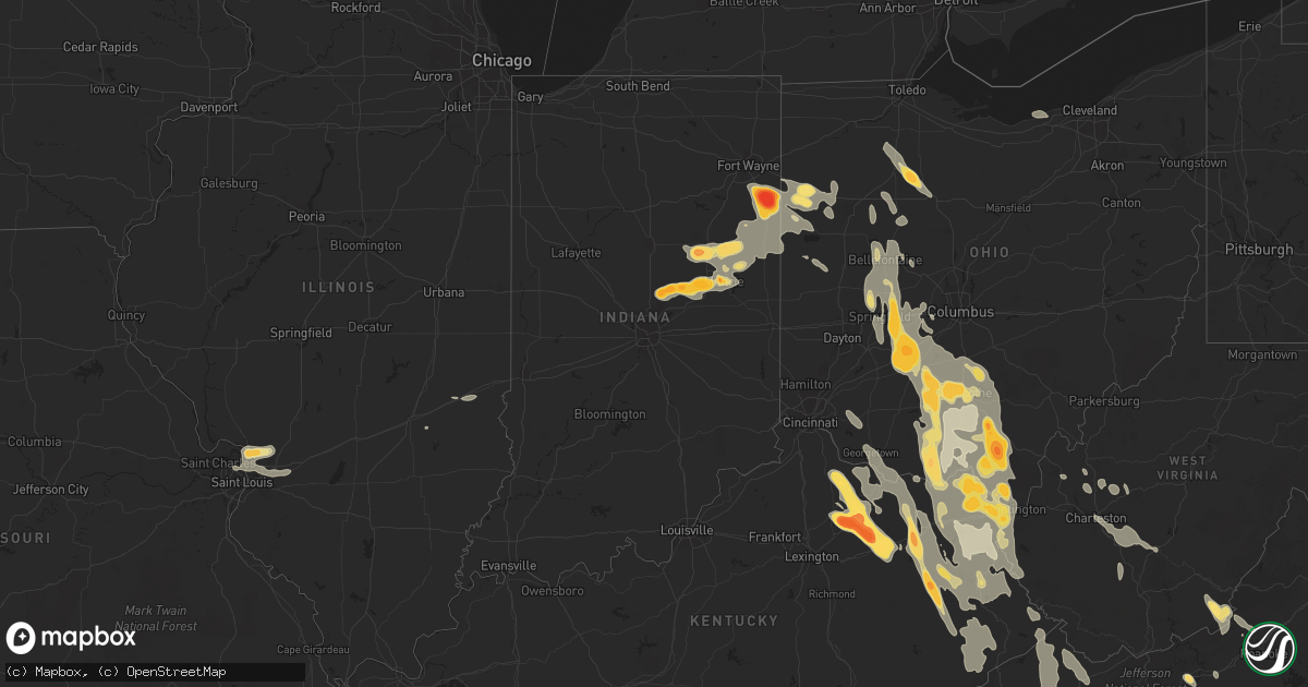
Hail Map in Kentucky on May 10, 2011
Get this storm
May 10 map
$229
one time, instant access
Download today. No call, no setup
Keep the $229
Bought the map and want the full workflow? Apply the entire $229 to a subscription within 7 days. None of it is wasted.
Every map, not just this one
This buys you this map. Subscription and you get every map we run, in the markets you choose from a few cities to whole states to nationwide. Plus real-time alerts the moment a storm fires.
Contact data
Name, contact info, occupancy, even credit band for addresses in the footprint. You go from where it hit to who to call.
Become the source they trust
Unlimited branding weather history reports on demand. You already have the documented answer ready for the property owner, and you are the one who showed up with it.
Property data and RoofTrace estimates
Pull up any address you have got, its value and the exact code rules for that jurisdiction, straight from One Click Code. Then RoofTrace estimates the squares, pitch, and roof value, priced the way you price.
Storm reports in Kentucky
Kentucky
| Date | Description |
|---|---|
| 05/10/20116:29 PM CDT | 4 to 5 foot tree uprooted and utility pole blown down in mount caramel. They also had a rotating wall cloud pass over the house. |
| 05/10/20116:12 PM CDT | A local report indicates 1.00 inch wind near MAYSVILLE |
| 05/10/20114:34 PM CDT | A local report indicates 1.25 inch wind near ASHLAND |
| 05/10/20114:32 PM CDT | A local report indicates 1.00 inch wind near ASHLAND |
| 05/10/20114:20 PM CDT | A local report indicates 1.00 inch wind near ASHLAND |
| 05/10/20114:16 PM CDT | Hail started out as pea sized and increased to quarter sized. |
| 05/10/20113:52 PM CDT | Quarter to golf ball sized hail reported. |
| 05/10/20113:49 PM CDT | A local report indicates 1.00 inch wind near ASHLAND |
| 05/10/20113:45 PM CDT | Hail occurred between 445 and 510 pm. Hail ranged in size from pea to quarter. |
| 05/10/20113:40 PM CDT | Trees down throughout the county. |
| 05/10/20113:33 PM CDT | A local report indicates 1.75 inch wind near 5 N CARLISLE |
| 05/10/20113:24 PM CDT | Reports of golf ball sized hail outside of argillite... Ky. |
| 05/10/20113:22 PM CDT | A local report indicates 1.00 inch wind near 5 N CARLISLE |
| 05/10/20113:22 PM CDT | Post office reports quarter sized hail on site... With patrons reporting golf ball sized in the area. |
| 05/10/20113:15 PM CDT | A local report indicates 1.00 inch wind near PRESTON |
| 05/10/20113:15 PM CDT | Hail occurred between 410 and 420 pm. |
| 05/10/20113:12 PM CDT | A local report indicates 1.00 inch wind near 4 SSW MOUNT OLIVET |
| 05/10/20113:06 PM CDT | A local report indicates 1.00 inch wind near PRESTON |
| 05/10/20113:06 PM CDT | A local report indicates 1.00 inch wind near STEPSTONE |
| 05/10/20112:45 PM CDT | A trained spotter witnessed golfball to baseball size hail in sharpsburg. The hail caused damage to cars in the area including broken windshields. |
| 05/10/20112:43 PM CDT | Hail caused dents in car. |
| 05/10/20112:35 PM CDT | A local report indicates 1.75 inch wind near NEAVE |
| 05/10/20112:31 PM CDT | A local report indicates 2.75 inch wind near CARLISLE |
| 05/10/20112:30 PM CDT | Many dented cars and broken windows |
| 05/10/20112:18 PM CDT | A local report indicates 1.75 inch wind near MILLERSBURG |
| 05/10/20112:15 PM CDT | A local report indicates 1.75 inch wind near 1 SE PIQUA |
| 05/10/20112:05 PM CDT | A local report indicates 1.00 inch wind near MILLERSBURG |
| 05/10/20112:03 PM CDT | A local report indicates 2.75 inch wind near MILLERSBURG |
| 05/10/20111:30 AM CDT | Quarter size hail was reported by law enforcement officers who were on a foot pursuit in the paintsville area. The hail also dented cars in the area. |
| 05/10/20111:22 AM CDT | A local report indicates 1.25 inch wind near 1 W PAINTSVILLE |
| 05/10/20111:18 AM CDT | A tree was blown down in sitka or about a mile west of galen. |
| 05/10/201112:00 AM CDT | A local report indicates 1.00 inch wind near GARRISON |
| 05/09/201111:34 PM CDT | Trees down on power poles and lines across north fork rd. |
| 05/09/20119:20 PM CDT | Quarter size hail was reported. |
| 05/09/20118:35 PM CDT | A local report indicates 1.75 inch wind near CANEY |
| 05/09/20118:32 PM CDT | A local report indicates 1.25 inch wind near 1 E MIZE |
| 05/09/20118:27 PM CDT | A local report indicates 1.00 inch wind near STACY FORK |
| 05/09/20118:22 PM CDT | Golf ball size hail caused damage to an automobile and a tow behind camper. |
| 05/09/20118:17 PM CDT | Roof blown of nichols apothecary and in the middle of the road. |
| 05/09/20118:16 PM CDT | Roof blown of nichols apothecary and in the middle of the road. |
| 05/09/20118:15 PM CDT | Tree across road at hambley ave. |
| 05/09/20118:15 PM CDT | A tree was blown down in langley between 915 and 920 pm. |
| 05/09/20118:14 PM CDT | Trees down on power lines on little card road. |
| 05/09/20118:13 PM CDT | Tree landed on collin street in collin. |
| 05/09/20118:00 PM CDT | Tree fell on vehicle near post office at edna on hwy 460. Driver injured. |
| 05/09/20118:00 PM CDT | Trees blown down across zebulon highway and privacy fence blown down. |
| 05/09/20118:00 PM CDT | Trees blown down on zebulon highway between double kwik and velocity. |
| 05/09/20117:36 PM CDT | A local report indicates 1.75 inch wind near CLEARFIELD |
| 05/09/20117:30 PM CDT | A local report indicates 1.00 inch wind near MOREHEAD |
| 05/09/20117:27 PM CDT | A local report indicates 1.00 inch wind near CRANSTON |
| 05/09/20117:27 PM CDT | A local report indicates 1.75 inch wind near HILDA |
| 05/09/20117:25 PM CDT | The fire chief reported that quarter size hail was falling in cranston off ky 377. |
| 05/09/20117:05 PM CDT | Numerous trees down |
| 05/09/20117:05 PM CDT | Numerous trees down |
All States Impacted by Hail Map on May 10, 2011
Cities Impacted by Hail Map on May 10, 2011
- Pease, MN
- Princeton, MN
- Foreston, MN
- Milaca, MN
- Berne, IN
- Ossian, IN
- Bluffton, IN
- Decatur, IN
- Monroe, IN
- Stone Lake, WI
- Hayward, WI
- Marine On Saint Croix, MN
- Hugo, MN
- Forest Lake, MN
- Scandia, MN
- Pamplico, SC
- Wabeno, WI
- White Lake, WI
- Concord, NC
- Charlotte, NC
- Huntersville, NC
- Harrisburg, NC
- Orrum, NC
- Fairmont, NC
- Hopkins, SC
- Columbia, SC
- Keystone, IN
- Andrews, SC
- Georgetown, SC
- Little River, SC
- Longs, SC
- Conway, SC
- Myrtle Beach, SC
- North Myrtle Beach, SC
- Loris, SC
- South Charleston, OH
- Thelma, KY
- Londonderry, OH
- Stoutsville, OH
- Greenfield, OH
- West Portsmouth, OH
- Williamsport, KY
- Salt Lick, KY
- Brooksville, KY
- Tollesboro, KY
- Circleville, OH
- Salyersville, KY
- Waverly, OH
- Mount Olivet, KY
- Tomahawk, KY
- Pilgrim, KY
- Wilsondale, WV
- Clarksburg, OH
- Adams, KY
- Coalton, OH
- Garrison, KY
- Sandy Hook, KY
- Patriot, OH
- River, KY
- Isonville, KY
- South Webster, OH
- Wallingford, KY
- Georgetown, OH
- Ulysses, KY
- Boons Camp, KY
- East Liberty, OH
- West Jefferson, OH
- Bloomingburg, OH
- Friendship, OH
- Latham, OH
- McArthur, OH
- New Holland, OH
- Morehead, KY
- Martha, KY
- Oil Springs, KY
- Warfield, KY
- Mayslick, KY
- Laurelville, OH
- Elkfork, KY
- Plain City, OH
- Clearfield, KY
- Cable, OH
- Lucasville, OH
- Aberdeen, OH
- Crum, WV
- Russellville, OH
- Blaine, KY
- Oak Hill, OH
- Beaver, OH
- Ironton, OH
- South Bloomingville, OH
- Royalton, KY
- Jackson, OH
- North Lewisburg, OH
- Inez, KY
- Sabina, OH
- Willow Wood, OH
- Russell, KY
- Emerson, KY
- Rushsylvania, OH
- Jamestown, OH
- Wellston, OH
- Prestonsburg, KY
- West Van Lear, KY
- Ceredo, WV
- Vanceburg, KY
- Belle Center, OH
- Mingo, OH
- Manchester, OH
- Huntsville, OH
- Prichard, WV
- Lowmansville, KY
- West Liberty, KY
- Rush, KY
- Mize, KY
- Campton, KY
- Flatwoods, KY
- Wellington, KY
- Urbana, OH
- Ripley, OH
- Wheelersburg, OH
- Chesapeake, OH
- Bellefontaine, OH
- Clayhole, KY
- Pedro, OH
- Vest, KY
- East Point, KY
- Blue Creek, OH
- Wittensville, KY
- Augusta, KY
- Kingston, OH
- West Union, OH
- London, OH
- Springfield, OH
- Dover, KY
- Genoa, WV
- Van Lear, KY
- Russells Point, OH
- Auxier, KY
- Ashland, KY
- Hitchins, KY
- Worthington, KY
- Debord, KY
- Kermit, WV
- New Carlisle, OH
- Washington Court House, OH
- Hagerhill, KY
- Franklin Furnace, OH
- West Liberty, OH
- Frankfort, OH
- Blue River, KY
- South Salem, OH
- Ray, OH
- Tremont City, OH
- Waterloo, OH
- Mount Sterling, OH
- Denton, KY
- Catlettsburg, KY
- Saint Paris, OH
- Minford, OH
- Flatgap, KY
- Jeffersonville, OH
- Olive Hill, KY
- Grayson, KY
- Cedarville, OH
- Huntington, WV
- Quincy, KY
- Catawba, OH
- Stambaugh, KY
- Thurman, OH
- Hamersville, OH
- Lavalette, WV
- Tutor Key, KY
- Fort Gay, WV
- Mechanicsburg, OH
- Wayne, WV
- Cannel City, KY
- Argillite, KY
- Louisa, KY
- Hillsboro, OH
- Adelphi, OH
- Rousseau, KY
- Kitts Hill, OH
- South Shore, KY
- Lakeview, OH
- Zanesfield, OH
- Staffordsville, KY
- Piketon, OH
- Portsmouth, OH
- Flemingsburg, KY
- Ezel, KY
- South Point, OH
- Hazel Green, KY
- Ewing, KY
- McDermott, OH
- South Solon, OH
- Lewistown, OH
- Kenova, WV
- Peebles, OH
- South Portsmouth, KY
- Paintsville, KY
- Yellow Springs, OH
- Vancleve, KY
- Chillicothe, OH
- South Vienna, OH
- West Mansfield, OH
- Jackson, KY
- Dunlow, WV
- Williamsport, OH
- Greenup, KY
- Germantown, KY
- Meally, KY
- Rarden, OH
- Bainbridge, OH
- Sitka, KY
- Stout, OH
- Richmond Dale, OH
- De Graff, OH
- Keaton, KY
- Maysville, KY
- Otway, OH
- Charleston, WV
- Kimberly, WV
- Mount Carbon, WV
- Kanawha Falls, WV
- Hugheston, WV
- Pond Gap, WV
- Hico, WV
- Belva, WV
- Cedar Grove, WV
- Glasgow, WV
- Lansing, WV
- Ansted, WV
- Handley, WV
- Fayetteville, WV
- Smithers, WV
- Gallagher, WV
- East Bank, WV
- Mammoth, WV
- Montgomery, WV
- Victor, WV
- Drybranch, WV
- London, WV
- Belle, WV
- Pratt, WV
- Hansford, WV
- Powellton, WV
- Gauley Bridge, WV
- Blount, WV
- Moorefield, KY
- Falmouth, KY
- Sharpsburg, KY
- Mount Sterling, KY
- Cynthiana, KY
- Millersburg, KY
- Paris, KY
- Olympia, KY
- Owingsville, KY
- Foster, KY
- Carlisle, KY
- Oak Park, MN
- Lugoff, SC
- Mooresville, NC
- Charleston, SC
- Mount Pleasant, SC
- Sullivans Island, SC
- Saint Croix Falls, WI
- Grantsburg, WI
- North Branch, MN
- Harris, MN
- Aynor, SC
- Galivants Ferry, SC
- Nichols, SC
- Foley, MN
- Effingham, SC
- Lake City, SC
- Johnsonville, SC
- Florence, SC
- Hemingway, SC
- Dugspur, VA
- Laurel Fork, VA
- Hillsville, VA
- Summitville, IN
- Fowlerton, IN
- Jonesboro, IN
- Fairmount, IN
- Chanhassen, MN
- Eden Prairie, MN
- Chaska, MN
- Clarkton, NC
- Whiteville, NC
- Bladenboro, NC
- Alton, IL
- Hartford, IL
- Moro, IL
- Wood River, IL
- West Alton, MO
- East Alton, IL
- South Roxana, IL
- Roxana, IL
- Saint Louis, MO
- Cottage Hills, IL
- Bethalto, IL
- Edwardsville, IL
- Southport, NC
- Bolivia, NC
- Kure Beach, NC
- Winnabow, NC
- Evergreen, NC
- Hallsboro, NC
- Perryton, TX
- Cicero, IN
- Noblesville, IN
- Arcadia, IN
- Frankton, IN
- Anderson, IN
- Simpsonville, SC
- Fountain Inn, SC
- Greenville, SC
- Van Wert, OH
- Travelers Rest, SC
- Mullins, SC
- Gresham, SC
- Marion, SC
- Green Sea, SC
- Fair Bluff, NC
- Jamestown, SC
- Arcadia, OH
- Alvada, OH
- Findlay, OH
- Vanlue, OH
- Carey, OH
- Mount Blanchard, OH
- Pulaski, VA
- Dublin, VA
- Claudville, VA
- Willis, VA
- Ararat, VA
- Masterson, TX
- Batavia, OH
- Goshen, OH
- Williamsburg, OH
- Gaston, IN
- Matthews, IN
- Eaton, IN
- Dunkirk, IN
- Upland, IN
- Hartford City, IN
- Gas City, IN
- Pennville, IN
- Montpelier, IN
- Muncie, IN
- Rock, KS
- Winfield, KS
- Awendaw, SC
- Isle Of Palms, SC
- Daleville, IN
- Yorktown, IN
- Alexandria, IN
- Trego, WI
- Spooner, WI
- Paint Bank, VA
- Troutville, VA
- New Castle, VA
- Liberty, WV
- Quail, TX
- Hedley, TX
- Atlanta, IN
- Rush City, MN
- Stanchfield, MN
- Braham, MN
- Cambridge, MN
- Pender, NE
- Wisner, NE
- Bancroft, NE
- Maria Stein, OH
- Saint Henry, OH
- Minnetonka, MN
- Hopkins, MN
- Minneapolis, MN
- Shakopee, MN
- Seagraves, TX
- Hamer, SC
- Rowland, NC
- Anoka, MN
- Elk River, MN
- Isanti, MN
- Saint Francis, MN
- Valdese, NC
- Connelly Springs, NC
- Drexel, NC
- Lawndale, NC
- Hickory, NC
- Morganton, NC
- Vale, NC
- Hildebran, NC
- Raymond, OH
- Marysville, OH
- Davidson, NC
- Siren, WI
- Webster, WI
- Saint Michael, MN
- Monticello, MN
- Albertville, MN
- Rogers, MN
- Yorkshire, OH
- Houston, OH
- Fort Loramie, OH
- McClellanville, SC
- Nesmith, SC
- Scranton, SC
- Shelby, NC
- Union Mills, NC
- Ellenboro, NC
- Forest City, NC
- Chesnee, SC
- Nebo, NC
- Mooresboro, NC
- Spindale, NC
- Bostic, NC
- Marion, NC
- Rutherfordton, NC
- Gaffney, SC
- Casar, NC
- Duncan, SC
- Wellford, SC
- Startex, SC
- Greer, SC
- Lyman, SC
- Plains, TX
- Squaw Lake, MN
- Northome, MN
- Radford, VA
- Harrod, OH
- Ada, OH
- Alger, OH
- Mora, MN
- Lorenzo, TX
- Floydada, TX
- Petersburg, TX
- Idalou, TX
- Silverton, TX
- Kress, TX
- Lockney, TX
- Happy, TX
- Tulia, TX
- Hope, KY
- Means, KY
- Taylors, SC
- Bowlus, MN
- Royalton, MN
- Pine City, MN
- Grasston, MN
- Quemado, TX
- Oakwood, VA
- Richlands, VA
- Bandy, VA
- Whitewood, VA
- Grundy, VA
- Cedar Bluff, VA
- Raven, VA
- Pilgrims Knob, VA
- Pounding Mill, VA
- Jewell Ridge, VA
- Springbrook, WI
- Frederic, WI
- Shell Lake, WI
- Ely, MN
- Union, WV
- Sinks Grove, WV
- Gap Mills, WV
- Secondcreekx, WV
- Excelsior, MN
- Saint Paul, MN
- Redkey, IN
- Ridgeville, IN
- Albany, IN
- Ronceverte, WV
- Waiteville, WV
- Pelican Lake, WI
- Rhinelander, WI
- Indian Valley, VA
- Fancy Gap, VA
- Meadows Of Dan, VA
- Mount Airy, NC
- Lumberton, NC
- Tabor City, NC
- Troutman, NC
- Dalbo, MN
- Sauk Rapids, MN
- Dieterich, IL
- Wheeler, IL
- Hi Hat, KY
- Raven, KY
- Jeremiah, KY
- Roxana, KY
- Beaver, KY
- Virgie, KY
- Millstone, KY
- McDowell, KY
- Thornton, KY
- Littcarr, KY
- Premium, KY
- Langley, KY
- Kite, KY
- Vicco, KY
- Grethel, KY
- Hindman, KY
- Ermine, KY
- Melvin, KY
- Whitesburg, KY
- Hueysville, KY
- Minnie, KY
- Topmost, KY
- Isom, KY
- Drift, KY
- Redfox, KY
- Mallie, KY
- Pine Top, KY
- Garrett, KY
- Pippa Passes, KY
- Bevinsville, KY
- Deane, KY
- Weeksbury, KY
- Wayland, KY
- Wheelwright, KY
- Blackey, KY
- Bypro, KY
- Mousie, KY
- Dema, KY
- Leburn, KY
- Garner, KY
- Lackey, KY
- Gunlock, KY
- Eastern, KY
- Booker, TX
- Balko, OK
- Dillon, SC
- Crivitz, WI
- Athelstane, WI
- Wausaukee, WI
- Walton, WV
- Clendenin, WV
- Amma, WV
- Hiwassee, VA
- Blooming Prairie, MN
- Ellendale, MN
- Riner, VA
- Christiansburg, VA
- Kings Mountain, NC
- Clover, SC
- Gastonia, NC
- Mount Ulla, NC
- China Grove, NC
- Cleveland, NC
- Ohio City, OH
- Middle Point, OH
- Campobello, SC
- Inman, SC
- Landrum, SC
- Greeneville, TN
- Chuckey, TN
- Afton, TN
- Monroe, NC
- Midland, NC
- Statesville, NC
- Kannapolis, NC
- Matthews, NC
- Cornelius, NC
- Indian Trail, NC
- Pineville, NC
- Saint Germain, WI
- Lac Du Flambeau, WI
- Minocqua, WI
- Woodruff, WI
- Boulder Junction, WI
- Sayner, WI
- Ogilvie, MN
- Eastover, SC
- Maxton, NC
- Frenchburg, KY
- Luck, WI
- Cushing, WI
- Lake View, SC
- Van Buren, OH
- Bloomdale, OH
- Wharton, OH
- McComb, OH
- Upper Sandusky, OH
- Custar, OH
- Cygnet, OH
- North Baltimore, OH
- Saint Matthews, SC
- Cameron, SC
- Hanahan, SC
- North Charleston, SC
- Goose Creek, SC
- Ladson, SC
- Advent, WV
- Kenna, WV
- Southside, WV
- Leon, WV
- Nakina, NC
- Spencerville, OH
- Lima, OH
- Loop, TX
- Brownfield, TX
- Claude, TX
- Beckley, WV
- Artie, WV
- Whitesville, WV
- Clear Creek, WV
- Eskdale, WV
- Iron River, MI
- Watersmeet, MI
- Crystal Falls, MI
- Trout Creek, MI
- Calabash, NC
- Sunset Beach, NC
- Vansant, VA
- Lebanon, VA
- Fedscreek, KY
- Rowe, VA
- Kimper, KY
- Hurley, VA
- Davenport, VA
- Cleveland, VA
- Phelps, KY
- Steele, KY
- Big Rock, VA
- Haysi, VA
- Bee, VA
- Honaker, VA
- Lubbock, TX
- Wolfforth, TX
- Given, WV
- Rockford, OH
- Hertel, WI
- Glen Carbon, IL
- Granite City, IL
- Highland, IL
- Saint Jacob, IL
- Maryville, IL
- Collinsville, IL
- Florissant, MO
- Troy, IL
- Wellington, TX
- Shamrock, TX
- Babbitt, MN
- Hereford, TX
- Church Hill, TN
- Duffield, VA
- Eidson, TN
- Surgoinsville, TN
- Gate City, VA
- Blacksburg, SC
- Grover, NC
- Greenup, IL
- Casey, IL
- Hardy, KY
- Belfry, KY
- Pinsonfork, KY
- Ransom, KY
- Canada, KY
- Stone, KY
- Huddy, KY
- Forest Hills, KY
- McAndrews, KY
- Center City, MN
- Buffalo, MN
- Sarona, WI
- Lindstrom, MN
- Grandy, MN
- Cedar, MN
- Stacy, MN
- Bethel, MN
- Heath Springs, SC
- Lancaster, SC
- Bruce Crossing, MI
- Ada, OK
- Woolwine, VA
- Pineville, SC
- Bonneau, SC
- Moncks Corner, SC
- Tahoka, TX
- Meadow, TX
- Gruver, TX
- Groom, TX
- Coward, SC
- Lane, SC
- Longwood, NC
- Timmonsville, SC
- Fork, SC
- Cordesville, SC
- Leland, NC
- Huger, SC
- Salters, SC
- Lake Waccamaw, NC
- Bolton, NC
- Murrells Inlet, SC
- Ocean Isle Beach, NC
- Chadbourn, NC
- Charleston Afb, SC
- Ridgeville, SC
- Folly Beach, SC
- Supply, NC
- Summerville, SC
- Ash, NC
- Cerro Gordo, NC
- Clarendon, NC
- Cades, SC
- Kingstree, SC
- Pembroke, NC
- Floyd, VA
- Catawba, VA
- Hillman, MN
- Bock, MN
- Clear Lake, MN
- Pierz, MN
- Rice, MN
- Saint Cloud, MN
- Lena, WI
- Suring, WI
- Gillett, WI
- Oconto Falls, WI
- Webbville, KY
- Gadsden, SC
- Elgin, SC
- Winnsboro, SC
- Ridgeway, SC
- Blythewood, SC
- Lovington, NM
- Hobbs, NM
- Morton, TX
- Whiteface, TX
- Littlefield, TX
- Levelland, TX
- Denver City, TX
- Seminole, TX
- Monroeville, IN
- Swayzee, IN
- Fort Wayne, IN
- Hoagland, IN
- Farmland, IN
- Venedocia, OH
- Cloverdale, OH
- Parker City, IN
- Fort Jennings, OH
- Selma, IN
- Willshire, OH
- Delphos, OH
- Craigville, IN
- Poneto, IN
- Marion, IN
- Convoy, OH
- Lapel, IN
- Portland, IN
- Bryant, IN
- Mendon, OH
- Geneva, IN
- Wren, OH
- Petroleum, IN
- Fort Recovery, OH
- Celina, OH
- Chassell, MI
- Wellston, OK
- Coyle, OK
- Meridian, OK
- Perkins, OK
- Cramerton, NC
- Lowell, NC
- Belmont, NC
- Ravenel, SC
- Sheffield Lake, OH
- Lorain, OH
- Cherryville, NC
- Stinnett, TX
- White Deer, TX
- Borger, TX
- Panhandle, TX
- Elkview, WV
- Bluffton, OH
- Jenera, OH
- Dola, OH
- Kenton, OH
- Dunkirk, OH
- Forest, OH
- Mauldin, SC
- Gray Court, SC
- Prior Lake, MN
- Wayzata, MN
- New Prague, MN
- Savage, MN
- Jordan, MN
- Martinsville, IL


