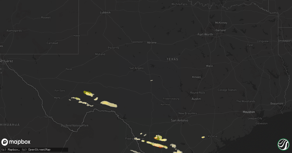
Hail Map in Texas on May 8, 2025
Get this storm
May 8 map
$229
one time, instant access
Download today. No call, no setup
Keep the $229
Bought the map and want the full workflow? Apply the entire $229 to a subscription within 7 days. None of it is wasted.
Every map, not just this one
This buys you this map. Subscription and you get every map we run, in the markets you choose from a few cities to whole states to nationwide. Plus real-time alerts the moment a storm fires.
Contact data
Name, contact info, occupancy, even credit band for addresses in the footprint. You go from where it hit to who to call.
Become the source they trust
Unlimited branding weather history reports on demand. You already have the documented answer ready for the property owner, and you are the one who showed up with it.
Property data and RoofTrace estimates
Pull up any address you have got, its value and the exact code rules for that jurisdiction, straight from One Click Code. Then RoofTrace estimates the squares, pitch, and roof value, priced the way you price.
Storm reports in Texas
Texas
| Date | Description |
|---|---|
| 05/08/20256:49 PM CDT | Pictures and video on x showed ping pong to golfball size hail north of rio grande city. |
| 05/08/20256:39 PM CDT | Report from mping: golf ball |
| 05/08/20256:24 PM CDT | Ranch owner sent video of estimated quarter sized hail. |
| 05/08/20256:10 PM CDT | Two tractor trailers blown over 5 ssw of town |
| 05/08/20255:45 PM CDT | Corrects previous tstm wnd dmg report from 3 ese carrizo springs. Structural damage to front porch and sideways bent 10 foot post that is secured to the ground; broken |
| 05/08/20255:40 PM CDT | 500 acres of corn destroyed. |
| 05/08/20255:35 PM CDT | Hail up to quarter size at intersection of us 83 and us 277. Time estimated via radar. |
| 05/08/20255:35 PM CDT | 3 to 6 inch diameter branches snapped off a tree in carrizo springs near intersection of us 83 and us 277; in addition to the 1 inch diameter hail. |
| 05/08/20255:33 PM CDT | Snapped power poles and signage at td rentals on hwy 277 in carrizo springs. Time estimated via radar. |
| 05/08/20254:56 PM CDT | Report of estimated baseball hail size received by trained storm spotter at the intersection of fm2687 and fm649. |
| 05/08/20253:45 PM CDT | Structural damage to front porch and sideways bent 10 foot post that is secured to the ground; broken window from possible wind debris or hail as well. |
| 05/08/20253:05 PM CDT | Broadcast media shared resident report of estimated 1 inch hail in weslaco. Time estimated based on radar data. |
| 05/08/20253:05 PM CDT | Broadcast media shared resident report of estimated 1 inch hail in weslaco. Time estimated based on radar data. |
| 05/08/20253:04 PM CDT | Mesonet station rget2 bibe rgv. |
| 05/08/20253:00 PM CDT | Mesonet station twb98 gray ranch. |
| 05/08/20252:52 PM CDT | Broadcast media shared video from resident with estimated quarter-sized hail at the intersection of mile 9 and 1015. |
| 05/08/20252:52 PM CDT | Broadcast media shared video from resident with estimated quarter-sized hail at the intersection of mile 9 and 1015. |
| 05/07/202511:02 PM CDT | Multiple accidents reported along us 77. 2 18 wheelers flipped southbound. 1 18 wheeler reported flipped northbound. |
| 05/07/202510:38 PM CDT | Multiple power lines and transmission lines down throughout the city of driscoll. |
| 05/07/202510:29 PM CDT | Public reported overturned 18 wheeler at us-77 and fm 665. |
| 05/07/202510:05 PM CDT | Mobile home blown off foundation into the street... Roof blown off carport. |
| 05/07/202510:00 PM CDT | Large trees uprooted. |
| 05/07/20259:46 PM CDT | Reported that their hurricane fence was blown over with lots of tree limbs down. Time was estimated on radar. |
| 05/07/20259:45 PM CDT | 30 ft tree uprooted causing damage to house roof and siding near la paloma off of cr 18 and cr 93. |
| 05/07/20259:39 PM CDT | Member of the public provided facebook photo comment showing approximately 2 inch hail. |
| 05/07/20259:35 PM CDT | 80 transmission lines blown down upon survey. Time estimated from radar. |
| 05/07/20259:30 PM CDT | Pictures of barn roof damage from social media. Time is estimated. |
| 05/07/20259:30 PM CDT | Received phone call report of trees snapped. An anchored playground was broken... Roof blown off and multiple area of roof damage. |
| 05/07/20259:30 PM CDT | Received phone call of a power outage... Mobile homes being blown into the street... Blown off roofs and collapsed carports in petronila. Time is estimated. |
| 05/07/20259:25 PM CDT | Large trees snapped... Playground equipment broken... Roof blown off into nearby field. |
| 05/07/20259:17 PM CDT | Reports received through em of a barn demolished on fm 1554. |
| 05/07/20259:17 PM CDT | Also reported pea-sized hail. |
| 05/07/20259:17 PM CDT | Reports of downed power lines and trees throughout the city of alice. |
| 05/07/20259:17 PM CDT | Report of two tractor trailers flipped over on hwy 281 and fm 1554. |
| 05/07/20259:17 PM CDT | Asos station kali alice- pk wind time report differs from the actual passage of strong winds... So time on this report is estimated on radar. |
| 05/07/20259:14 PM CDT | Two to three ft diameter tree blown over and possibly hit with lightning. |
| 05/07/20259:10 PM CDT | Many uprooted trees and downed power poles. |
| 05/07/20259:00 PM CDT | Public report from social media: lost a barn and several homes lost parts of their roof. Time is estimated. |
| 05/07/20259:00 PM CDT | Roof blown off of a horse barn and several large trees down. Report received via phone call. |
| 05/07/20259:00 PM CDT | Photos received on social media of a collapsed metal building structure. |
| 05/07/20258:48 PM CDT | Video recording of metal shed/garage blown over with damage to farming equipment/vehicles. Time estimated off radar. |
| 05/07/20258:09 PM CDT | Report received via fb. Also recorded 1.4 inches of rainfall. Time estimated from radar. |
| 05/07/20258:03 PM CDT | Duval county ems reported a jack-knifed 18 wheeler n of freer. |
| 05/07/20257:50 PM CDT | Member of the public posted facebook photo verified location based on radar of a hailstone approximately 1.5 inches. |
| 05/07/20257:31 PM CDT | Trained spotted reported receiving estimated golf ball sized hail on vehicle driving on the expressway just ne of donna. |
| 05/07/20257:24 PM CDT | Member of the public posted facebook photo |
| 05/07/20257:18 PM CDT | Member of the public posted a facebook photo comment showing an approximately golf ball sized hailstone taken at this location. |
| 05/07/20257:18 PM CDT | Trained skywarn spotter reported golf ball sized hail around the intersection of wisconsin and veterans. |
| 05/07/20257:18 PM CDT | Member of the public pasted a facebook comment of a photo of hailstone approximately 3 inches long and 1.5 inches wide. |
| 05/07/20257:18 PM CDT | A local report indicates 1.00 inch wind near 3 S Edinburg |
| 05/07/20257:17 PM CDT | Report from mping: half dollar |
| 05/07/20257:15 PM CDT | Member of the public posted facebook photo comment with location and timestamp... Approximately 1 inch. |
| 05/07/20257:12 PM CDT | Member of the public left a facebook comment with video showing approximately golf ball sized hail at this intersection. Reported minor vehicle damage... As well as dam |
| 05/07/20257:10 PM CDT | Member of the public sent a photo through a facebook message showing hailstones approximately 2 inches. |
| 05/07/20257:10 PM CDT | Member of the public posted a photo comment via facebook showing approximately 1 inch hail. |
| 05/07/20257:10 PM CDT | Photo received from dhr health of a 2 inch sized measured hailstone that fell near dove and mccoll. |
| 05/07/20257:08 PM CDT | Member of the public posted facebook photo comment showing approximately golf ball sized hailstone. |
| 05/07/20257:07 PM CDT | Local em reported estimated ping pong ball sized hail at residence and provided a photo. |
| 05/07/20257:05 PM CDT | Report received from ham operator of 1 inch estimated hail falling for 10 minutes duration. |
| 05/07/20257:05 PM CDT | Member of the public sent photos through facebook message showing approximately golf ball-sized hail. |
| 05/07/20257:00 PM CDT | Member of the public posted facebook video of downed fence and trees. |
All States Impacted by Hail Map on May 8, 2025
Cities Impacted by Hail Map on May 8, 2025
- Bristol, FL
- Eastpoint, FL
- Rio Hondo, TX
- South Padre Island, TX
- Menard, TX
- Brady, TX
- Marathon, TX
- Fort Stockton, TX
- East Prairie, MO
- Gleason, TN
- Centertown, KY
- Beaver Dam, KY
- McHenry, KY
- McKenzie, TN
- Henry, TN
- Paris, TN
- Dryden, TX
- Eldorado, IL
- Raleigh, IL
- Springville, TN
- Mansfield, TN
- Register, GA
- Metter, GA
- Big Sandy, TN
- Sikeston, MO
- Brooklet, GA
- Pembroke, GA
- Cromwell, KY
- Horse Branch, KY
- Stewart, TN
- Waverly, TN
- Statesboro, GA
- Martin, TN
- Sharon, TN
- Fillmore, IN
- Cloverdale, IN
- Greencastle, IN
- Henderson, KY
- Robards, KY
- Sylvania, GA
- Harrisburg, IL
- Tennessee Ridge, TN
- Erin, TN
- Owensboro, KY
- Calhoun, KY
- Bertrand, MO
- Charleston, MO
- Pontotoc, MS
- Equality, IL
- Savannah, GA
- Hardeeville, SC
- Morgantown, KY
- Dresden, TN
- Ellabell, GA
- Tupelo, MS
- Belden, MS
- Comstock, TX
- Pinson, TN
- Junction, IL
- Morganfield, KY
- Puryear, TN
- Bluffton, SC
- Okatie, SC
- Herod, IL
- Caneyville, KY
- Leitchfield, KY
- Brownsville, KY
- Utica, KY
- Uniontown, KY
- Port Wentworth, GA
- Blue Springs, MS
- Henderson, TN
- Beech Bluff, TN
- Buchanan, TN
- Bee Spring, KY
- Clarkson, KY
- Waverly, KY
- Clay, KY
- Williamsburg, KY
- Jacks Creek, TN
- Midway, GA
- Reagan, TN
- Luray, TN
- Huron, TN
- Vanleer, TN
- McEwen, TN
- Plantersville, MS
- Bloomingdale, GA
- Hardyville, KY
- Canmer, KY
- Greensburg, KY
- Rutherfordton, NC
- Lake Lure, NC
- Mill Spring, NC
- Siler, KY
- Riceboro, GA
- Fulton, MS
- Mooreville, MS
- Leicester, NC
- Cumberland Furnace, TN
- Enville, TN
- Hot Springs, NC
- Donna, TX
- Okolona, MS
- Pooler, GA
- Mantachie, MS
- Hohenwald, TN
- Lexington, TN
- Sardis, TN
- Scotts Hill, TN
- Decaturville, TN
- Bath Springs, TN
- Charlotte, TN
- Nettleton, MS
- Pineville, KY
- Barbourville, KY
- Trosper, KY
- Weslaco, TX
- Dickson, TN
- Mercedes, TX
- Richmond Hill, GA
- Fort Stewart, GA
- Summertown, TN
- Guyton, GA
- Drakesboro, KY
- Central City, KY
- White Bluff, TN
- Ashland City, TN
- Union Mills, NC
- Mount Pleasant, TN
- Rockholds, KY
- Hendersonville, NC
- Kilmichael, MS
- Medon, TN
- Asheville, NC
- Alexander, NC
- Franklin, TN
- Marion, NC
- Fourmile, KY
- Twin City, GA
- Crossville, TN
- Pikeville, TN
- Marianna, FL
- Fletcher, NC
- Clifton, TN
- Linden, TN
- Nebo, NC
- Brentwood, TN
- Campbellsville, KY
- Eupora, MS
- Mathiston, MS
- Lancing, TN
- Winter Haven, FL
- Flat Lick, KY
- Wilkesboro, NC
- Fairview, NC
- Morganton, NC
- Amory, MS
- Hilham, TN
- Celina, TN
- Rockport, KY
- Edcouch, TX
- Santa Rosa, TX
- Laredo, TX
- Ferguson, NC
- Boomer, NC
- Maben, MS
- Pheba, MS
- Starkville, MS
- Swannanoa, NC
- Nashville, TN
- Walker, KY
- Stewart, MS
- French Camp, MS
- Quemado, TX
- Allons, TN
- Old Fort, NC
- Woodbine, KY
- Townsend, GA
- Corbin, KY
- Black Mountain, NC
- Smithville, MS
- Lynnville, TN
- Waynesboro, TN
- San Ygnacio, TX
- Auburndale, FL
- Artemus, KY
- Bremen, KY
- Harlingen, TX
- Antioch, TN
- Whites Creek, TN
- Madison, TN
- Bryants Store, KY
- Moravian Falls, NC
- Robbins, TN
- Somerset, KY
- Portal, GA
- Culleoka, TN
- Hudson, NC
- Granite Falls, NC
- Beverly, KY
- Stoney Fork, KY
- Helton, KY
- Manchester, KY
- Arlington, KY
- Clinton, KY
- Toone, TN
- Bolivar, TN
- Crystal City, TX
- Albany, KY
- Alpha, KY
- Weir, MS
- Bardwell, KY
- Garfield, GA
- Warbranch, KY
- Apopka, FL
- Mozelle, KY
- Roark, KY
- Ocoee, FL
- Essie, KY
- Stinnett, KY
- Big Creek, KY
- Hyden, KY
- London, KY
- Bostic, NC
- Monticello, KY
- Bimble, KY
- Marble, NC
- Murphy, NC
- Huntsville, TN
- Greenwood Springs, MS
- Byrdstown, TN
- Detroit, AL
- Hornsby, TN
- Bethel Springs, TN
- Hebbronville, TX
- Kingston Springs, TN
- Pegram, TN
- Zapata, TX
- Eagle Pass, TX
- Tremont, MS
- Lewisburg, TN
- Hermitage, TN
- Joelton, TN
- West Point, MS
- Columbus, MS
- Centerville, TN
- Santa Fe, TN
- Williamsport, TN
- Duck River, TN
- Primm Springs, TN
- Orlando, FL
- Keavy, KY
- Lenoir, NC
- Mount Juliet, TN
- Lawrenceburg, TN
- Taylorsville, NC
- Pioneer, TN
- Forest City, NC
- Beaverton, AL
- Sulligent, AL
- Burkesville, KY
- Gerton, NC
- Chappell, KY
- Jackson, TN
- Valdese, NC
- Douglas, GA
- Lebanon, TN
- Old Hickory, TN
- La Vergne, TN
- Whitleyville, TN
- Wartburg, TN
- Guerra, TX
- Connelly Springs, NC
- Guin, AL
- Hamilton, AL
- Ethridge, TN
- Tazewell, TN
- North Wilkesboro, NC
- Roaring River, NC
- Watertown, TN
- Armstrong, TX
- Yeaddiss, KY
- Wooton, KY
- Lily, KY
- Lascassas, TN
- Murfreesboro, TN
- Newcomb, TN
- Alexandria, TN
- Liberty, TN
- Auburntown, TN
- Smyrna, TN
- Nolensville, TN
- Gray, KY
- Hickory, NC
- Brilliant, AL
- Heidrick, KY
- Winfield, AL
- Fort Gay, WV
- La Follette, TN
- Haysi, VA
- Big Rock, VA
- Breaks, VA
- Whitley City, KY
- Calvin, KY
- Milton, TN
- Edgewater, FL
- New Smyrna Beach, FL
- Ellenboro, NC
- Mooresboro, NC
- Hiddenite, NC
- Pisgah Forest, NC
- Darien, GA
- Nicholls, GA
- West Green, GA
- Hamptonville, NC
- Stafford, VA
- Winfield, TN
- Gotha, FL
- Stearns, KY
- Dowelltown, TN
- Jellico, TN
- Goliad, TX
- Casar, NC
- Genoa, WV
- Wayne, WV
- Shelby, NC
- Lawndale, NC
- Carrizo Springs, TX
- Oak Hill, FL
- Encino, TX
- Middlesboro, KY
- Elkfork, KY
- Mills River, NC
- Alma, GA
- Horse Shoe, NC
- East Lynn, WV
- Dunlow, WV
- Kiahsville, WV
- Sandy Hook, KY
- Isonville, KY
- West Liberty, KY
- Martha, KY
- Keaton, KY
- Flatgap, KY
- Ranger, WV
- Ethelsville, AL
- Baker, FL
- Vale, NC
- Arden, NC
- Cashiers, NC
- Highlands, NC
- Batesville, TX
- Baxley, GA
- Miracle, KY
- Lynn, AL
- Nauvoo, AL
- Savannah, TN
- Cherryville, NC
- Roma, TX
- Andrews, NC
- Pine Knot, KY
- Rio Grande City, TX
- Lincolnton, NC
- Spindale, NC
- Stuart, VA
- Bassett, VA
- Henry, VA
- Harts, WV
- Branchland, WV
- Chapmanville, WV
- Blaine, KY
- Sitka, KY
- Stambaugh, KY
- College Grove, TN
- Arrington, TN
- Sapphire, NC
- Osteen, FL
- Hazard, KY
- Laurel Hill, FL
- Carrollton, AL
- Reform, AL
- Grover, NC
- Purlear, NC
- Millers Creek, NC
- Mims, FL
- Glenville, NC
- Sunbright, TN
- Dilley, TX
- Sanford, FL
- Patrick Springs, VA
- Scalf, KY
- Warren, MA
- West Brookfield, MA
- Cotulla, TX
- Critz, VA
- Spencer, VA
- Dobson, NC
- Elkin, NC
- Mount Airy, NC
- Sassafras, KY
- Big Creek, WV
- McGrady, NC
- Lowmansville, KY
- Louisa, KY
- Hays, NC
- Prestonsburg, KY
- Carrie, KY
- Hindman, KY
- Santa Elena, TX
- Sweetwater, TN
- Philadelphia, TN
- Big Wells, TX
- Asherton, TX
- Catarina, TX
- Lake Toxaway, NC
- Ten Mile, TN
- Andalusia, AL
- Florala, AL
- Spring City, TN
- Martinsville, VA
- Frakes, KY
- Rocky Mount, VA
- Lutts, TN
- Collinwood, TN
- Jacksonville, GA
- Glade Hill, VA
- Kings Mountain, NC
- Guntersville, AL
- Penhook, VA
- Ridgeway, VA
- Garciasville, TX
- Danville, WV
- Turtle Creek, WV
- Hewett, WV
- Pecks Mill, WV
- Lake, WV
- Yolyn, WV
- Chatham, VA
- Emmalena, KY
- Longwood, FL
- Pulaski, TN
- Petersburg, TN
- Frankewing, TN
- Madisonville, TN
- Vonore, TN
- Brevard, NC
- China Grove, NC
- Union Grove, AL
- Prospect, TN
- Ardmore, TN
- Grulla, TX
- Greenback, TN
- Maryville, TN
- Tallassee, TN
- Gastonia, NC
- Niota, TN
- Fayetteville, TN
- Mission, TX
- Edinburg, TX
- Jeffrey, WV
- Clothier, WV
- Amherstdale, WV
- River, KY
- Cumberland Gap, TN
- Stoneville, NC
- Iron City, TN
- Westpoint, TN
- Eskdale, WV
- Ewing, VA
- Harrogate, TN
- Uvalda, GA
- Kannapolis, NC
- Landis, NC
- Lyons, GA
- Caryville, TN
- Opp, AL
- Kimberly, WV
- Powellton, WV
- Montgomery, WV
- Kincaid, WV
- Robson, WV
- Bim, WV
- Ulysses, KY
- Pikeville, KY
- Decatur, TN
- Kinston, AL
- Gallagher, WV
- Robbinsville, NC
- Boons Camp, KY
- Paintsville, KY
- Vidalia, GA
- Stanleytown, VA
- Delmita, TX
- Chesnee, SC
- Elba, AL
- Houston, MS
- Woodland, MS
- Danbury, NC
- Walnut Cove, NC
- East Point, KY
- Assaria, KS
- Salina, KS
- Lindsborg, KS
- Athens, TN
- Dellrose, TN
- Rockwell, NC
- Loudon, TN
- Allen, KY
- Lake Mary, FL
- Ackerman, MS
- Mcallen, TX
- Clayhole, KY
- Jackson, KY
- Varney, KY
- Kimper, KY
- Mocksville, NC
- Spencer, TN
- Linefork, KY
- Whitesburg, KY
- Hallie, KY
- Cornettsville, KY
- Jack, AL
- Evensville, TN
- Garner, KY
- Leburn, KY
- Wharton, WV
- Defuniak Springs, FL
- Crab Orchard, TN
- Maitland, FL
- Winter Park, FL
- Inez, KY
- Debord, KY
- Sidney, KY
- Canada, KY
- McAndrews, KY
- Pinsonfork, KY
- Stone, KY
- Ransom, KY
- Pharr, TX
- Rockwood, TN
- Deland, FL
- Mulberry, TN
- Gordo, AL
- Cosby, TN
- Traphill, NC
- Sneedville, TN
- Smithville, TN
- Oneida, TN
- Cyclone, WV
- Brundidge, AL
- Helenwood, TN
- Teaberry, KY
- Beaver, KY
- McDowell, KY
- Harold, KY
- State Road, NC
- Ronda, NC
- Belvidere, TN
- Kelso, TN
- Englewood, TN
- Clover, SC
- Hartford, TN
- Fontana Dam, NC
- Americus, GA
- San Juan, TX
- Alamo, TX
- Fayetteville, WV
- Oceana, WV
- Naoma, WV
- Arnett, WV
- Bolt, WV
- Ariton, AL
- Fieldale, VA
- Gainesboro, TN
- Fowlerton, TX
- Tilden, TX
- York, SC
- Del Rio, TN
- Baxter, TN
- Buffalo Valley, TN
- Bloomington Springs, TN
- Chestnut Mound, TN
- Granville, TN
- Elmwood, TN
- Grethel, KY
- Enterprise, AL
- New Brockton, AL
- Vest, KY
- Daytona Beach, FL
- Rock Hill, SC
- Progreso, TX
- Sandy Ridge, NC
- Java, VA
- Nathalie, VA
- Salem, VA
- Daleville, VA
- Roanoke, VA
- Troutville, VA
- Eutaw, AL
- Catawba, VA
- Winchester, TN
- Tellico Plains, TN
- Wirtz, VA
- Moneta, VA
- Cuthbert, GA
- Morris, GA
- Grundy, VA
- Lumpkin, GA
- Cloverdale, VA
- Berry, AL
- Smyrna, SC
- Rose Hill, VA
- Knoxville, AL
- Albemarle, NC
- Locust, NC
- Smithville, GA
- Halifax, VA
- Denton, NC
- Freer, TX
- Calliham, TX
- Lawsonville, NC
- Vienna, GA
- Mount Vernon, KY
- Ralph, AL
- Sherwood, TN
- Axton, VA
- Logan, WV
- Speedwell, TN
- Plains, GA
- Loretto, TN
- South Pittsburg, TN
- Westfield, NC
- Callands, VA
- Fort Mill, SC
- Blue Ridge, VA
- Advance, NC
- Smiths Grove, KY
- Glasgow, KY
- Park City, KY
- Moundville, AL
- Akron, AL
- San Diego, TX
- Belfry, KY
- Williamson, WV
- Stopover, KY
- Phelps, KY
- Phyllis, KY
- Freeburn, KY
- Majestic, KY
- Matewan, WV
- Flintville, TN
- Pinehurst, GA
- Candler, NC
- Canton, NC
- McCarr, KY
- Fosters, AL
- Grandview, TN
- Arab, AL
- Woodville, AL
- New Hope, AL
- Bastian, VA
- Rocky Gap, VA
- Narrows, VA
- Somerville, AL
- Asheboro, NC
- Star, NC
- Troy, NC
- Grant, AL
- Hollywood, AL
- Fackler, AL
- Hartselle, AL
- Charlotte, NC
- Stevenson, AL
- Waxhaw, NC
- Scottsboro, AL
- Falkville, AL
- Arjay, KY
- Bankston, AL
- Fayette, AL
- New London, NC
- Catawba, SC
- Thurmond, NC
- Collinsville, VA
- Reliance, TN
- Carthage, NC
- Harmony, NC
- Union Grove, NC
- Leslie, GA
- Lexington, VA
- Glasgow, VA
- Natural Bridge, VA
- Chattanooga, TN
- Alice, TX
- Lancaster, SC
- East Bernstadt, KY
- Orange Grove, TX
- Dwale, KY
- Kingston, GA
- Stanville, KY
- Guild, TN
- Whitwell, TN
- Jasper, TN
- Lookout Mountain, TN
- Cartersville, GA
- White, GA
- Trenton, GA
- Tuckasegee, NC
- Gaylesville, AL
- Sewanee, TN
- Bishop, TX
- Robstown, TX
- Jonesville, VA
- Penitas, TX
- Sullivan City, TX
- Cleveland, TN
- Apison, TN
- Ringgold, GA
- Cohutta, GA
- Rossville, GA
- Cedar Bluff, AL
- Morris Chapel, TN
- Wildwood, GA
- Scaly Mountain, NC
- Corpus Christi, TX
- Columbus, NC
- Tryon, NC
- San Benito, TX
- La Feria, TX
- Hi Hat, KY
- Rock Island, TN
- Pippa Passes, KY
- Waterloo, AL
- Newburgh, IN
- Parrottsville, TN
- Union, SC
- Greeneville, TN
- Huntland, TN
- Carlisle, SC
- Whitmire, SC
- Sequatchie, TN
- Chester, SC
- Sharon, SC
- Rome, GA
- Pineville, NC
- Bulls Gap, TN
- Mosheim, TN
- Blair, SC
- McConnells, SC
- Sparta, GA
- Milledgeville, GA
- Gray, GA
- Haddock, GA
- Edgefield, SC
- Johnston, SC
- Eatonton, GA
- Ridge Spring, SC
- Ward, SC
- Ridgeway, SC
- Liberty Hill, SC
- Camden, SC
- Monetta, SC
- Madison, GA
- Cassatt, SC
- North Augusta, SC
- Clarks Hill, SC
- Bethune, SC
- Graniteville, SC
- White Plains, GA
- Greensboro, GA
- Bishopville, SC
- Trenton, SC
- Crawfordville, GA
- Berlin, MD
- Aiken, SC
- Lovely, KY
- Holden, WV
- Lenore, WV
- Dingess, WV
- Stollings, WV
- Warrenville, SC
- Batesburg, SC
- Bybee, TN
- Newport, TN
- Abbeville, SC
- Calhoun Falls, SC
- Florence, SC
- Salley, SC
- Williston, SC
- Windsor, SC
- Blackville, SC
- Springfield, SC
- Marion, SC
- Mullins, SC
- Nichols, SC
- Bamberg, SC
- Green Sea, SC
- Branchville, SC
- Smoaks, SC
- Reevesville, SC
- Ware, MA
- West Warren, MA
- Cottageville, SC
- New Tazewell, TN
- Cottage Grove, TN
- Smilax, KY
- Cana, VA
- Ararat, VA
- Claudville, VA
- Meadows Of Dan, VA
- Vinton, VA
- Buena Vista, VA
- Bronston, KY
- Wendover, KY
- Viper, KY
- Slemp, KY
- Tutor Key, KY
- Tomahawk, KY
- Hagerhill, KY


