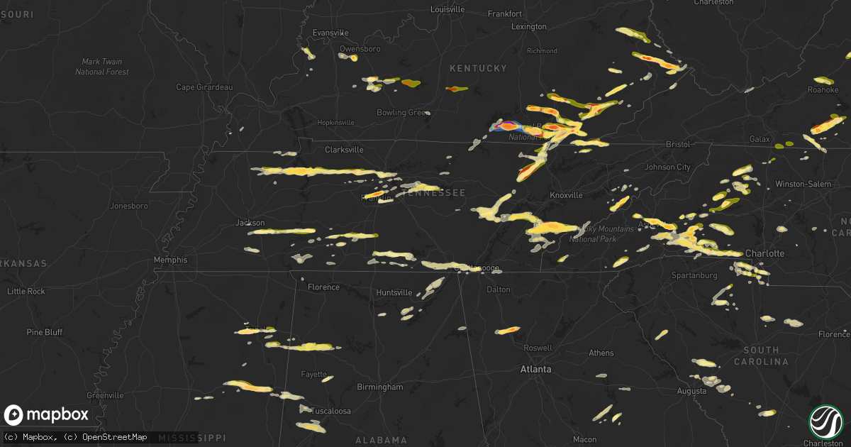
Hail Map in Tennessee on May 8, 2025
Get this storm
May 8 map
$229
one time, instant access
Download today. No call, no setup
Keep the $229
Bought the map and want the full workflow? Apply the entire $229 to a subscription within 7 days. None of it is wasted.
Every map, not just this one
This buys you this map. Subscription and you get every map we run, in the markets you choose from a few cities to whole states to nationwide. Plus real-time alerts the moment a storm fires.
Contact data
Name, contact info, occupancy, even credit band for addresses in the footprint. You go from where it hit to who to call.
Become the source they trust
Unlimited branding weather history reports on demand. You already have the documented answer ready for the property owner, and you are the one who showed up with it.
Property data and RoofTrace estimates
Pull up any address you have got, its value and the exact code rules for that jurisdiction, straight from One Click Code. Then RoofTrace estimates the squares, pitch, and roof value, priced the way you price.
Storm reports in Tennessee
Tennessee
| Date | Description |
|---|---|
| 05/08/20256:49 PM CDT | Public reported nickel to quarter size hail in crab orchard. Time estimated based on radar. |
| 05/08/20256:30 PM CDT | Quarter size hail. |
| 05/08/20256:26 PM CDT | Tennis ball size hail. |
| 05/08/20256:25 PM CDT | Photo of a large hail stone817 |
| 05/08/20256:25 PM CDT | Ping pong ball size hail. |
| 05/08/20256:25 PM CDT | Photo of a large hail stone estimated to be 2 inches in diameter... Via a social media post. Time is estimated from radar. |
| 05/08/20256:19 PM CDT | Golf ball size hail. |
| 05/08/20256:18 PM CDT | A local report indicates 1.25 inch wind near 4 ENE Pikeville |
| 05/08/20256:15 PM CDT | Golf ball size hail. |
| 05/08/20256:13 PM CDT | Quarter size hail. |
| 05/08/20256:07 PM CDT | Ping pong ball size hail. |
| 05/08/20255:58 PM CDT | Quarter size hail. |
| 05/08/20255:36 PM CDT | A local report indicates 1.00 inch wind near 4 NE Ten Mile |
| 05/08/20255:26 PM CDT | Report from mping: ping pong ball |
| 05/08/20254:59 PM CDT | Public reported quarter size hail on tramel branch rd. |
| 05/08/20254:56 PM CDT | Half dollar size hail on old liberty rd. . |
| 05/08/20254:56 PM CDT | Half dollar size hail on old liberty rd. |
| 05/08/20254:44 PM CDT | Public reported quarter to half dollar size hail on fite rd. |
| 05/08/20254:15 PM CDT | Exact location is estimated. |
| 05/08/20254:15 PM CDT | Several large branches were blown down along mcgavock pk. |
| 05/08/20254:03 PM CDT | Tspotter report shows 1 inch hail near mcgavock pike and briley parkway. |
| 05/08/20254:03 PM CDT | Tspotter report shows 1 inch hail near mcgavock pike and briley parkway. |
| 05/08/20254:00 PM CDT | Quarter size hail in ninemile. |
| 05/08/20253:58 PM CDT | Tree down on riverside drive near inglewood elementary school. |
| 05/08/20253:57 PM CDT | Quarter sized hail in inglewood tn. |
| 05/08/20253:56 PM CDT | Up to one inch hail on cahal ave. |
| 05/08/20253:55 PM CDT | A tree fell through the roof of a home on lichey ave. Time estimated from radar. |
| 05/08/20253:55 PM CDT | Half inch to one inch hail at ellington parkway and trinity ln. |
| 05/08/20253:55 PM CDT | A large tree was blown down at tanyard hollow rd near valley creek rd along with copious amounts of small hail. |
| 05/08/20253:54 PM CDT | Tspotter report showed a large tree down at cleveland park in east nashville. Time estimated from radar. |
| 05/08/20253:52 PM CDT | Tree down near the intersection of joseph ave and douglas ave. |
| 05/08/20253:45 PM CDT | Mix of quarter size 1.0 inch to golf ball 1.75 inch diameter hail that caused minor damage to vehicles. |
| 05/08/20253:40 PM CDT | Facebook report of quarter hail at wilson pk and concord rd. |
| 05/08/20253:30 PM CDT | Quarter sized hail in fieldstone farms... Franklin tn. Social media report. |
| 05/08/20253:30 PM CDT | Hail in a mixture of sizes... As large as ping pong balls. |
| 05/08/20253:28 PM CDT | 2 inch hail on hwy 96 in franklin... Tn. Reported via social media. |
| 05/08/20253:28 PM CDT | Report from mping: quarter |
| 05/08/20253:18 PM CDT | Ham radio operator reports quarter sized hail on old hillsboro rd near leipers fork. Time estimated. |
| 05/08/20253:17 PM CDT | Quarter sized hail in ashland city. Social media report. |
| 05/08/20252:59 PM CDT | A local report indicates 2.00 inch wind near 4 ESE Big Sandy |
| 05/08/20252:45 PM CDT | Hail up to quarter size was reported in charlotte. |
| 05/08/20252:35 PM CDT | A local report indicates 1.00 inch wind near 2 WSW Reagan |
| 05/08/20252:20 PM CDT | Photo of half-dollar sized hail on the west side of paris. |
| 05/08/20252:13 PM CDT | A local report indicates 1.00 inch wind near 3 SE Mifflin |
| 05/08/20252:05 PM CDT | Needmore rd and highway 200. |
| 05/08/20251:23 PM CDT | Corrects previous hail report from 4 ese big sandy. |
| 05/08/20251:14 PM CDT | Trees down on danville road. |
| 05/08/20251:13 PM CDT | A local report indicates 1.25 inch wind near Big Sandy |
| 05/08/20251:13 PM CDT | A local report indicates 64 MPH wind near Big Sandy |
| 05/08/20251:13 PM CDT | Trees and power lines down on bain road. |
| 05/08/20251:10 PM CDT | A local report indicates 1.50 inch wind near Springville |
| 05/07/20259:12 PM CDT | Report from mping: quarter |
| 05/07/20259:11 PM CDT | Quarter size hail. |
| 05/07/20258:30 PM CDT | Social media photo of hailstones up to quarter-sized. Time estimated from radar. |
| 05/07/20257:48 PM CDT | A local report indicates 1.00 inch wind near 4 NE Del Rio |
| 05/07/20257:45 PM CDT | Social media photo of very large hailstones... Estimated to be 2 inches in diameter. Time is estimated from radar. |
| 05/07/20257:40 PM CDT | A local report indicates 1.75 inch wind near 2 SE Del Rio |
| 05/07/20257:35 PM CDT | Social media photo of a very large hailstone... Estimated to be the size of a baseball. Time is estimated from radar. |
| 05/07/20257:30 PM CDT | Photo of lots of small hail around a 0.5 to 0.75 inch with the largest stones being around quarter size 1.0 inch in diameter. Time estimated by radar. |
All States Impacted by Hail Map on May 8, 2025
Cities Impacted by Hail Map on May 8, 2025
- Bristol, FL
- Eastpoint, FL
- Rio Hondo, TX
- South Padre Island, TX
- Menard, TX
- Brady, TX
- Marathon, TX
- Fort Stockton, TX
- East Prairie, MO
- Gleason, TN
- Centertown, KY
- Beaver Dam, KY
- McHenry, KY
- McKenzie, TN
- Henry, TN
- Paris, TN
- Dryden, TX
- Eldorado, IL
- Raleigh, IL
- Springville, TN
- Mansfield, TN
- Register, GA
- Metter, GA
- Big Sandy, TN
- Sikeston, MO
- Brooklet, GA
- Pembroke, GA
- Cromwell, KY
- Horse Branch, KY
- Stewart, TN
- Waverly, TN
- Statesboro, GA
- Martin, TN
- Sharon, TN
- Fillmore, IN
- Cloverdale, IN
- Greencastle, IN
- Henderson, KY
- Robards, KY
- Sylvania, GA
- Harrisburg, IL
- Tennessee Ridge, TN
- Erin, TN
- Owensboro, KY
- Calhoun, KY
- Bertrand, MO
- Charleston, MO
- Pontotoc, MS
- Equality, IL
- Savannah, GA
- Hardeeville, SC
- Morgantown, KY
- Dresden, TN
- Ellabell, GA
- Tupelo, MS
- Belden, MS
- Comstock, TX
- Pinson, TN
- Junction, IL
- Morganfield, KY
- Puryear, TN
- Bluffton, SC
- Okatie, SC
- Herod, IL
- Caneyville, KY
- Leitchfield, KY
- Brownsville, KY
- Utica, KY
- Uniontown, KY
- Port Wentworth, GA
- Blue Springs, MS
- Henderson, TN
- Beech Bluff, TN
- Buchanan, TN
- Bee Spring, KY
- Clarkson, KY
- Waverly, KY
- Clay, KY
- Williamsburg, KY
- Jacks Creek, TN
- Midway, GA
- Reagan, TN
- Luray, TN
- Huron, TN
- Vanleer, TN
- McEwen, TN
- Plantersville, MS
- Bloomingdale, GA
- Hardyville, KY
- Canmer, KY
- Greensburg, KY
- Rutherfordton, NC
- Lake Lure, NC
- Mill Spring, NC
- Siler, KY
- Riceboro, GA
- Fulton, MS
- Mooreville, MS
- Leicester, NC
- Cumberland Furnace, TN
- Enville, TN
- Hot Springs, NC
- Donna, TX
- Okolona, MS
- Pooler, GA
- Mantachie, MS
- Hohenwald, TN
- Lexington, TN
- Sardis, TN
- Scotts Hill, TN
- Decaturville, TN
- Bath Springs, TN
- Charlotte, TN
- Nettleton, MS
- Pineville, KY
- Barbourville, KY
- Trosper, KY
- Weslaco, TX
- Dickson, TN
- Mercedes, TX
- Richmond Hill, GA
- Fort Stewart, GA
- Summertown, TN
- Guyton, GA
- Drakesboro, KY
- Central City, KY
- White Bluff, TN
- Ashland City, TN
- Union Mills, NC
- Mount Pleasant, TN
- Rockholds, KY
- Hendersonville, NC
- Kilmichael, MS
- Medon, TN
- Asheville, NC
- Alexander, NC
- Franklin, TN
- Marion, NC
- Fourmile, KY
- Twin City, GA
- Crossville, TN
- Pikeville, TN
- Marianna, FL
- Fletcher, NC
- Clifton, TN
- Linden, TN
- Nebo, NC
- Brentwood, TN
- Campbellsville, KY
- Eupora, MS
- Mathiston, MS
- Lancing, TN
- Winter Haven, FL
- Flat Lick, KY
- Wilkesboro, NC
- Fairview, NC
- Morganton, NC
- Amory, MS
- Hilham, TN
- Celina, TN
- Rockport, KY
- Edcouch, TX
- Santa Rosa, TX
- Laredo, TX
- Ferguson, NC
- Boomer, NC
- Maben, MS
- Pheba, MS
- Starkville, MS
- Swannanoa, NC
- Nashville, TN
- Walker, KY
- Stewart, MS
- French Camp, MS
- Quemado, TX
- Allons, TN
- Old Fort, NC
- Woodbine, KY
- Townsend, GA
- Corbin, KY
- Black Mountain, NC
- Smithville, MS
- Lynnville, TN
- Waynesboro, TN
- San Ygnacio, TX
- Auburndale, FL
- Artemus, KY
- Bremen, KY
- Harlingen, TX
- Antioch, TN
- Whites Creek, TN
- Madison, TN
- Bryants Store, KY
- Moravian Falls, NC
- Robbins, TN
- Somerset, KY
- Portal, GA
- Culleoka, TN
- Hudson, NC
- Granite Falls, NC
- Beverly, KY
- Stoney Fork, KY
- Helton, KY
- Manchester, KY
- Arlington, KY
- Clinton, KY
- Toone, TN
- Bolivar, TN
- Crystal City, TX
- Albany, KY
- Alpha, KY
- Weir, MS
- Bardwell, KY
- Garfield, GA
- Warbranch, KY
- Apopka, FL
- Mozelle, KY
- Roark, KY
- Ocoee, FL
- Essie, KY
- Stinnett, KY
- Big Creek, KY
- Hyden, KY
- London, KY
- Bostic, NC
- Monticello, KY
- Bimble, KY
- Marble, NC
- Murphy, NC
- Huntsville, TN
- Greenwood Springs, MS
- Byrdstown, TN
- Detroit, AL
- Hornsby, TN
- Bethel Springs, TN
- Hebbronville, TX
- Kingston Springs, TN
- Pegram, TN
- Zapata, TX
- Eagle Pass, TX
- Tremont, MS
- Lewisburg, TN
- Hermitage, TN
- Joelton, TN
- West Point, MS
- Columbus, MS
- Centerville, TN
- Santa Fe, TN
- Williamsport, TN
- Duck River, TN
- Primm Springs, TN
- Orlando, FL
- Keavy, KY
- Lenoir, NC
- Mount Juliet, TN
- Lawrenceburg, TN
- Taylorsville, NC
- Pioneer, TN
- Forest City, NC
- Beaverton, AL
- Sulligent, AL
- Burkesville, KY
- Gerton, NC
- Chappell, KY
- Jackson, TN
- Valdese, NC
- Douglas, GA
- Lebanon, TN
- Old Hickory, TN
- La Vergne, TN
- Whitleyville, TN
- Wartburg, TN
- Guerra, TX
- Connelly Springs, NC
- Guin, AL
- Hamilton, AL
- Ethridge, TN
- Tazewell, TN
- North Wilkesboro, NC
- Roaring River, NC
- Watertown, TN
- Armstrong, TX
- Yeaddiss, KY
- Wooton, KY
- Lily, KY
- Lascassas, TN
- Murfreesboro, TN
- Newcomb, TN
- Alexandria, TN
- Liberty, TN
- Auburntown, TN
- Smyrna, TN
- Nolensville, TN
- Gray, KY
- Hickory, NC
- Brilliant, AL
- Heidrick, KY
- Winfield, AL
- Fort Gay, WV
- La Follette, TN
- Haysi, VA
- Big Rock, VA
- Breaks, VA
- Whitley City, KY
- Calvin, KY
- Milton, TN
- Edgewater, FL
- New Smyrna Beach, FL
- Ellenboro, NC
- Mooresboro, NC
- Hiddenite, NC
- Pisgah Forest, NC
- Darien, GA
- Nicholls, GA
- West Green, GA
- Hamptonville, NC
- Stafford, VA
- Winfield, TN
- Gotha, FL
- Stearns, KY
- Dowelltown, TN
- Jellico, TN
- Goliad, TX
- Casar, NC
- Genoa, WV
- Wayne, WV
- Shelby, NC
- Lawndale, NC
- Carrizo Springs, TX
- Oak Hill, FL
- Encino, TX
- Middlesboro, KY
- Elkfork, KY
- Mills River, NC
- Alma, GA
- Horse Shoe, NC
- East Lynn, WV
- Dunlow, WV
- Kiahsville, WV
- Sandy Hook, KY
- Isonville, KY
- West Liberty, KY
- Martha, KY
- Keaton, KY
- Flatgap, KY
- Ranger, WV
- Ethelsville, AL
- Baker, FL
- Vale, NC
- Arden, NC
- Cashiers, NC
- Highlands, NC
- Batesville, TX
- Baxley, GA
- Miracle, KY
- Lynn, AL
- Nauvoo, AL
- Savannah, TN
- Cherryville, NC
- Roma, TX
- Andrews, NC
- Pine Knot, KY
- Rio Grande City, TX
- Lincolnton, NC
- Spindale, NC
- Stuart, VA
- Bassett, VA
- Henry, VA
- Harts, WV
- Branchland, WV
- Chapmanville, WV
- Blaine, KY
- Sitka, KY
- Stambaugh, KY
- College Grove, TN
- Arrington, TN
- Sapphire, NC
- Osteen, FL
- Hazard, KY
- Laurel Hill, FL
- Carrollton, AL
- Reform, AL
- Grover, NC
- Purlear, NC
- Millers Creek, NC
- Mims, FL
- Glenville, NC
- Sunbright, TN
- Dilley, TX
- Sanford, FL
- Patrick Springs, VA
- Scalf, KY
- Warren, MA
- West Brookfield, MA
- Cotulla, TX
- Critz, VA
- Spencer, VA
- Dobson, NC
- Elkin, NC
- Mount Airy, NC
- Sassafras, KY
- Big Creek, WV
- McGrady, NC
- Lowmansville, KY
- Louisa, KY
- Hays, NC
- Prestonsburg, KY
- Carrie, KY
- Hindman, KY
- Santa Elena, TX
- Sweetwater, TN
- Philadelphia, TN
- Big Wells, TX
- Asherton, TX
- Catarina, TX
- Lake Toxaway, NC
- Ten Mile, TN
- Andalusia, AL
- Florala, AL
- Spring City, TN
- Martinsville, VA
- Frakes, KY
- Rocky Mount, VA
- Lutts, TN
- Collinwood, TN
- Jacksonville, GA
- Glade Hill, VA
- Kings Mountain, NC
- Guntersville, AL
- Penhook, VA
- Ridgeway, VA
- Garciasville, TX
- Danville, WV
- Turtle Creek, WV
- Hewett, WV
- Pecks Mill, WV
- Lake, WV
- Yolyn, WV
- Chatham, VA
- Emmalena, KY
- Longwood, FL
- Pulaski, TN
- Petersburg, TN
- Frankewing, TN
- Madisonville, TN
- Vonore, TN
- Brevard, NC
- China Grove, NC
- Union Grove, AL
- Prospect, TN
- Ardmore, TN
- Grulla, TX
- Greenback, TN
- Maryville, TN
- Tallassee, TN
- Gastonia, NC
- Niota, TN
- Fayetteville, TN
- Mission, TX
- Edinburg, TX
- Jeffrey, WV
- Clothier, WV
- Amherstdale, WV
- River, KY
- Cumberland Gap, TN
- Stoneville, NC
- Iron City, TN
- Westpoint, TN
- Eskdale, WV
- Ewing, VA
- Harrogate, TN
- Uvalda, GA
- Kannapolis, NC
- Landis, NC
- Lyons, GA
- Caryville, TN
- Opp, AL
- Kimberly, WV
- Powellton, WV
- Montgomery, WV
- Kincaid, WV
- Robson, WV
- Bim, WV
- Ulysses, KY
- Pikeville, KY
- Decatur, TN
- Kinston, AL
- Gallagher, WV
- Robbinsville, NC
- Boons Camp, KY
- Paintsville, KY
- Vidalia, GA
- Stanleytown, VA
- Delmita, TX
- Chesnee, SC
- Elba, AL
- Houston, MS
- Woodland, MS
- Danbury, NC
- Walnut Cove, NC
- East Point, KY
- Assaria, KS
- Salina, KS
- Lindsborg, KS
- Athens, TN
- Dellrose, TN
- Rockwell, NC
- Loudon, TN
- Allen, KY
- Lake Mary, FL
- Ackerman, MS
- Mcallen, TX
- Clayhole, KY
- Jackson, KY
- Varney, KY
- Kimper, KY
- Mocksville, NC
- Spencer, TN
- Linefork, KY
- Whitesburg, KY
- Hallie, KY
- Cornettsville, KY
- Jack, AL
- Evensville, TN
- Garner, KY
- Leburn, KY
- Wharton, WV
- Defuniak Springs, FL
- Crab Orchard, TN
- Maitland, FL
- Winter Park, FL
- Inez, KY
- Debord, KY
- Sidney, KY
- Canada, KY
- McAndrews, KY
- Pinsonfork, KY
- Stone, KY
- Ransom, KY
- Pharr, TX
- Rockwood, TN
- Deland, FL
- Mulberry, TN
- Gordo, AL
- Cosby, TN
- Traphill, NC
- Sneedville, TN
- Smithville, TN
- Oneida, TN
- Cyclone, WV
- Brundidge, AL
- Helenwood, TN
- Teaberry, KY
- Beaver, KY
- McDowell, KY
- Harold, KY
- State Road, NC
- Ronda, NC
- Belvidere, TN
- Kelso, TN
- Englewood, TN
- Clover, SC
- Hartford, TN
- Fontana Dam, NC
- Americus, GA
- San Juan, TX
- Alamo, TX
- Fayetteville, WV
- Oceana, WV
- Naoma, WV
- Arnett, WV
- Bolt, WV
- Ariton, AL
- Fieldale, VA
- Gainesboro, TN
- Fowlerton, TX
- Tilden, TX
- York, SC
- Del Rio, TN
- Baxter, TN
- Buffalo Valley, TN
- Bloomington Springs, TN
- Chestnut Mound, TN
- Granville, TN
- Elmwood, TN
- Grethel, KY
- Enterprise, AL
- New Brockton, AL
- Vest, KY
- Daytona Beach, FL
- Rock Hill, SC
- Progreso, TX
- Sandy Ridge, NC
- Java, VA
- Nathalie, VA
- Salem, VA
- Daleville, VA
- Roanoke, VA
- Troutville, VA
- Eutaw, AL
- Catawba, VA
- Winchester, TN
- Tellico Plains, TN
- Wirtz, VA
- Moneta, VA
- Cuthbert, GA
- Morris, GA
- Grundy, VA
- Lumpkin, GA
- Cloverdale, VA
- Berry, AL
- Smyrna, SC
- Rose Hill, VA
- Knoxville, AL
- Albemarle, NC
- Locust, NC
- Smithville, GA
- Halifax, VA
- Denton, NC
- Freer, TX
- Calliham, TX
- Lawsonville, NC
- Vienna, GA
- Mount Vernon, KY
- Ralph, AL
- Sherwood, TN
- Axton, VA
- Logan, WV
- Speedwell, TN
- Plains, GA
- Loretto, TN
- South Pittsburg, TN
- Westfield, NC
- Callands, VA
- Fort Mill, SC
- Blue Ridge, VA
- Advance, NC
- Smiths Grove, KY
- Glasgow, KY
- Park City, KY
- Moundville, AL
- Akron, AL
- San Diego, TX
- Belfry, KY
- Williamson, WV
- Stopover, KY
- Phelps, KY
- Phyllis, KY
- Freeburn, KY
- Majestic, KY
- Matewan, WV
- Flintville, TN
- Pinehurst, GA
- Candler, NC
- Canton, NC
- McCarr, KY
- Fosters, AL
- Grandview, TN
- Arab, AL
- Woodville, AL
- New Hope, AL
- Bastian, VA
- Rocky Gap, VA
- Narrows, VA
- Somerville, AL
- Asheboro, NC
- Star, NC
- Troy, NC
- Grant, AL
- Hollywood, AL
- Fackler, AL
- Hartselle, AL
- Charlotte, NC
- Stevenson, AL
- Waxhaw, NC
- Scottsboro, AL
- Falkville, AL
- Arjay, KY
- Bankston, AL
- Fayette, AL
- New London, NC
- Catawba, SC
- Thurmond, NC
- Collinsville, VA
- Reliance, TN
- Carthage, NC
- Harmony, NC
- Union Grove, NC
- Leslie, GA
- Lexington, VA
- Glasgow, VA
- Natural Bridge, VA
- Chattanooga, TN
- Alice, TX
- Lancaster, SC
- East Bernstadt, KY
- Orange Grove, TX
- Dwale, KY
- Kingston, GA
- Stanville, KY
- Guild, TN
- Whitwell, TN
- Jasper, TN
- Lookout Mountain, TN
- Cartersville, GA
- White, GA
- Trenton, GA
- Tuckasegee, NC
- Gaylesville, AL
- Sewanee, TN
- Bishop, TX
- Robstown, TX
- Jonesville, VA
- Penitas, TX
- Sullivan City, TX
- Cleveland, TN
- Apison, TN
- Ringgold, GA
- Cohutta, GA
- Rossville, GA
- Cedar Bluff, AL
- Morris Chapel, TN
- Wildwood, GA
- Scaly Mountain, NC
- Corpus Christi, TX
- Columbus, NC
- Tryon, NC
- San Benito, TX
- La Feria, TX
- Hi Hat, KY
- Rock Island, TN
- Pippa Passes, KY
- Waterloo, AL
- Newburgh, IN
- Parrottsville, TN
- Union, SC
- Greeneville, TN
- Huntland, TN
- Carlisle, SC
- Whitmire, SC
- Sequatchie, TN
- Chester, SC
- Sharon, SC
- Rome, GA
- Pineville, NC
- Bulls Gap, TN
- Mosheim, TN
- Blair, SC
- McConnells, SC
- Sparta, GA
- Milledgeville, GA
- Gray, GA
- Haddock, GA
- Edgefield, SC
- Johnston, SC
- Eatonton, GA
- Ridge Spring, SC
- Ward, SC
- Ridgeway, SC
- Liberty Hill, SC
- Camden, SC
- Monetta, SC
- Madison, GA
- Cassatt, SC
- North Augusta, SC
- Clarks Hill, SC
- Bethune, SC
- Graniteville, SC
- White Plains, GA
- Greensboro, GA
- Bishopville, SC
- Trenton, SC
- Crawfordville, GA
- Berlin, MD
- Aiken, SC
- Lovely, KY
- Holden, WV
- Lenore, WV
- Dingess, WV
- Stollings, WV
- Warrenville, SC
- Batesburg, SC
- Bybee, TN
- Newport, TN
- Abbeville, SC
- Calhoun Falls, SC
- Florence, SC
- Salley, SC
- Williston, SC
- Windsor, SC
- Blackville, SC
- Springfield, SC
- Marion, SC
- Mullins, SC
- Nichols, SC
- Bamberg, SC
- Green Sea, SC
- Branchville, SC
- Smoaks, SC
- Reevesville, SC
- Ware, MA
- West Warren, MA
- Cottageville, SC
- New Tazewell, TN
- Cottage Grove, TN
- Smilax, KY
- Cana, VA
- Ararat, VA
- Claudville, VA
- Meadows Of Dan, VA
- Vinton, VA
- Buena Vista, VA
- Bronston, KY
- Wendover, KY
- Viper, KY
- Slemp, KY
- Tutor Key, KY
- Tomahawk, KY
- Hagerhill, KY


