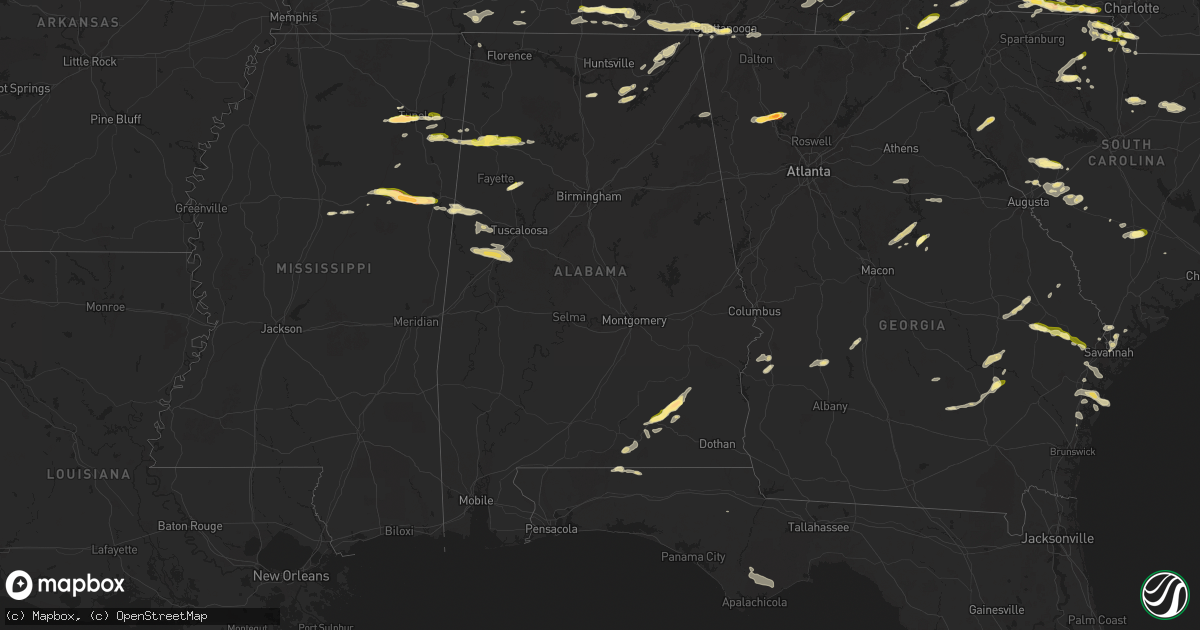
Hail Map in Alabama on May 8, 2025
Get this storm
May 8 map
$229
one time, instant access
Download today. No call, no setup
Keep the $229
Bought the map and want the full workflow? Apply the entire $229 to a subscription within 7 days. None of it is wasted.
Every map, not just this one
This buys you this map. Subscription and you get every map we run, in the markets you choose from a few cities to whole states to nationwide. Plus real-time alerts the moment a storm fires.
Contact data
Name, contact info, occupancy, even credit band for addresses in the footprint. You go from where it hit to who to call.
Become the source they trust
Unlimited branding weather history reports on demand. You already have the documented answer ready for the property owner, and you are the one who showed up with it.
Property data and RoofTrace estimates
Pull up any address you have got, its value and the exact code rules for that jurisdiction, straight from One Click Code. Then RoofTrace estimates the squares, pitch, and roof value, priced the way you price.
Storm reports in Alabama
Alabama
| Date | Description |
|---|---|
| 05/08/20256:45 PM CDT | 1.5 inch hail on 87 towards zion chapel. Reported by public via social media. |
| 05/08/20256:40 PM CDT | Photos and videos on social media of hail around quarter size north of elba. |
| 05/08/20255:18 PM CDT | Numerous trees reported down between hwy 13 and hwy 5 in winston county. Time estimated by radar. |
| 05/08/20254:48 PM CDT | Public reports hail estimated to be quarter-sized with 2nd storm that moved over the location. Time estimated by radar. |
| 05/07/20258:06 PM CDT | Quarter size hail reported in boley springs. |
| 05/07/20257:58 PM CDT | A few trees were downed by outflow winds in the springfield community north of eutaw. |
| 05/07/20257:50 PM CDT | Quarter sized hail covering ground near union. Time estimated by radar. |
| 05/07/20257:25 PM CDT | Social media report of multiple trees down in the tabernacle area. |
| 05/07/20257:16 PM CDT | Public reported hail up to quarter-sized along cr 79. |
| 05/07/20257:14 PM CDT | Up to golf ball size hail in the tarentum/hamilton crossroads area. |
| 05/07/20257:10 PM CDT | Golf ball and larger size hail reported by ham skywarn spotter near the county line. |
| 05/07/20257:10 PM CDT | Photo on social media of hail estimated at 2 inches in diameter from the roeton area in northeast coffee county. |
| 05/07/20257:00 PM CDT | Public reported quarter size hail near victoria al via social media. Picture with quarter for comparison. |
All States Impacted by Hail Map on May 8, 2025
Cities Impacted by Hail Map on May 8, 2025
- Bristol, FL
- Eastpoint, FL
- Rio Hondo, TX
- South Padre Island, TX
- Menard, TX
- Brady, TX
- Marathon, TX
- Fort Stockton, TX
- East Prairie, MO
- Gleason, TN
- Centertown, KY
- Beaver Dam, KY
- McHenry, KY
- McKenzie, TN
- Henry, TN
- Paris, TN
- Dryden, TX
- Eldorado, IL
- Raleigh, IL
- Springville, TN
- Mansfield, TN
- Register, GA
- Metter, GA
- Big Sandy, TN
- Sikeston, MO
- Brooklet, GA
- Pembroke, GA
- Cromwell, KY
- Horse Branch, KY
- Stewart, TN
- Waverly, TN
- Statesboro, GA
- Martin, TN
- Sharon, TN
- Fillmore, IN
- Cloverdale, IN
- Greencastle, IN
- Henderson, KY
- Robards, KY
- Sylvania, GA
- Harrisburg, IL
- Tennessee Ridge, TN
- Erin, TN
- Owensboro, KY
- Calhoun, KY
- Bertrand, MO
- Charleston, MO
- Pontotoc, MS
- Equality, IL
- Savannah, GA
- Hardeeville, SC
- Morgantown, KY
- Dresden, TN
- Ellabell, GA
- Tupelo, MS
- Belden, MS
- Comstock, TX
- Pinson, TN
- Junction, IL
- Morganfield, KY
- Puryear, TN
- Bluffton, SC
- Okatie, SC
- Herod, IL
- Caneyville, KY
- Leitchfield, KY
- Brownsville, KY
- Utica, KY
- Uniontown, KY
- Port Wentworth, GA
- Blue Springs, MS
- Henderson, TN
- Beech Bluff, TN
- Buchanan, TN
- Bee Spring, KY
- Clarkson, KY
- Waverly, KY
- Clay, KY
- Williamsburg, KY
- Jacks Creek, TN
- Midway, GA
- Reagan, TN
- Luray, TN
- Huron, TN
- Vanleer, TN
- McEwen, TN
- Plantersville, MS
- Bloomingdale, GA
- Hardyville, KY
- Canmer, KY
- Greensburg, KY
- Rutherfordton, NC
- Lake Lure, NC
- Mill Spring, NC
- Siler, KY
- Riceboro, GA
- Fulton, MS
- Mooreville, MS
- Leicester, NC
- Cumberland Furnace, TN
- Enville, TN
- Hot Springs, NC
- Donna, TX
- Okolona, MS
- Pooler, GA
- Mantachie, MS
- Hohenwald, TN
- Lexington, TN
- Sardis, TN
- Scotts Hill, TN
- Decaturville, TN
- Bath Springs, TN
- Charlotte, TN
- Nettleton, MS
- Pineville, KY
- Barbourville, KY
- Trosper, KY
- Weslaco, TX
- Dickson, TN
- Mercedes, TX
- Richmond Hill, GA
- Fort Stewart, GA
- Summertown, TN
- Guyton, GA
- Drakesboro, KY
- Central City, KY
- White Bluff, TN
- Ashland City, TN
- Union Mills, NC
- Mount Pleasant, TN
- Rockholds, KY
- Hendersonville, NC
- Kilmichael, MS
- Medon, TN
- Asheville, NC
- Alexander, NC
- Franklin, TN
- Marion, NC
- Fourmile, KY
- Twin City, GA
- Crossville, TN
- Pikeville, TN
- Marianna, FL
- Fletcher, NC
- Clifton, TN
- Linden, TN
- Nebo, NC
- Brentwood, TN
- Campbellsville, KY
- Eupora, MS
- Mathiston, MS
- Lancing, TN
- Winter Haven, FL
- Flat Lick, KY
- Wilkesboro, NC
- Fairview, NC
- Morganton, NC
- Amory, MS
- Hilham, TN
- Celina, TN
- Rockport, KY
- Edcouch, TX
- Santa Rosa, TX
- Laredo, TX
- Ferguson, NC
- Boomer, NC
- Maben, MS
- Pheba, MS
- Starkville, MS
- Swannanoa, NC
- Nashville, TN
- Walker, KY
- Stewart, MS
- French Camp, MS
- Quemado, TX
- Allons, TN
- Old Fort, NC
- Woodbine, KY
- Townsend, GA
- Corbin, KY
- Black Mountain, NC
- Smithville, MS
- Lynnville, TN
- Waynesboro, TN
- San Ygnacio, TX
- Auburndale, FL
- Artemus, KY
- Bremen, KY
- Harlingen, TX
- Antioch, TN
- Whites Creek, TN
- Madison, TN
- Bryants Store, KY
- Moravian Falls, NC
- Robbins, TN
- Somerset, KY
- Portal, GA
- Culleoka, TN
- Hudson, NC
- Granite Falls, NC
- Beverly, KY
- Stoney Fork, KY
- Helton, KY
- Manchester, KY
- Arlington, KY
- Clinton, KY
- Toone, TN
- Bolivar, TN
- Crystal City, TX
- Albany, KY
- Alpha, KY
- Weir, MS
- Bardwell, KY
- Garfield, GA
- Warbranch, KY
- Apopka, FL
- Mozelle, KY
- Roark, KY
- Ocoee, FL
- Essie, KY
- Stinnett, KY
- Big Creek, KY
- Hyden, KY
- London, KY
- Bostic, NC
- Monticello, KY
- Bimble, KY
- Marble, NC
- Murphy, NC
- Huntsville, TN
- Greenwood Springs, MS
- Byrdstown, TN
- Detroit, AL
- Hornsby, TN
- Bethel Springs, TN
- Hebbronville, TX
- Kingston Springs, TN
- Pegram, TN
- Zapata, TX
- Eagle Pass, TX
- Tremont, MS
- Lewisburg, TN
- Hermitage, TN
- Joelton, TN
- West Point, MS
- Columbus, MS
- Centerville, TN
- Santa Fe, TN
- Williamsport, TN
- Duck River, TN
- Primm Springs, TN
- Orlando, FL
- Keavy, KY
- Lenoir, NC
- Mount Juliet, TN
- Lawrenceburg, TN
- Taylorsville, NC
- Pioneer, TN
- Forest City, NC
- Beaverton, AL
- Sulligent, AL
- Burkesville, KY
- Gerton, NC
- Chappell, KY
- Jackson, TN
- Valdese, NC
- Douglas, GA
- Lebanon, TN
- Old Hickory, TN
- La Vergne, TN
- Whitleyville, TN
- Wartburg, TN
- Guerra, TX
- Connelly Springs, NC
- Guin, AL
- Hamilton, AL
- Ethridge, TN
- Tazewell, TN
- North Wilkesboro, NC
- Roaring River, NC
- Watertown, TN
- Armstrong, TX
- Yeaddiss, KY
- Wooton, KY
- Lily, KY
- Lascassas, TN
- Murfreesboro, TN
- Newcomb, TN
- Alexandria, TN
- Liberty, TN
- Auburntown, TN
- Smyrna, TN
- Nolensville, TN
- Gray, KY
- Hickory, NC
- Brilliant, AL
- Heidrick, KY
- Winfield, AL
- Fort Gay, WV
- La Follette, TN
- Haysi, VA
- Big Rock, VA
- Breaks, VA
- Whitley City, KY
- Calvin, KY
- Milton, TN
- Edgewater, FL
- New Smyrna Beach, FL
- Ellenboro, NC
- Mooresboro, NC
- Hiddenite, NC
- Pisgah Forest, NC
- Darien, GA
- Nicholls, GA
- West Green, GA
- Hamptonville, NC
- Stafford, VA
- Winfield, TN
- Gotha, FL
- Stearns, KY
- Dowelltown, TN
- Jellico, TN
- Goliad, TX
- Casar, NC
- Genoa, WV
- Wayne, WV
- Shelby, NC
- Lawndale, NC
- Carrizo Springs, TX
- Oak Hill, FL
- Encino, TX
- Middlesboro, KY
- Elkfork, KY
- Mills River, NC
- Alma, GA
- Horse Shoe, NC
- East Lynn, WV
- Dunlow, WV
- Kiahsville, WV
- Sandy Hook, KY
- Isonville, KY
- West Liberty, KY
- Martha, KY
- Keaton, KY
- Flatgap, KY
- Ranger, WV
- Ethelsville, AL
- Baker, FL
- Vale, NC
- Arden, NC
- Cashiers, NC
- Highlands, NC
- Batesville, TX
- Baxley, GA
- Miracle, KY
- Lynn, AL
- Nauvoo, AL
- Savannah, TN
- Cherryville, NC
- Roma, TX
- Andrews, NC
- Pine Knot, KY
- Rio Grande City, TX
- Lincolnton, NC
- Spindale, NC
- Stuart, VA
- Bassett, VA
- Henry, VA
- Harts, WV
- Branchland, WV
- Chapmanville, WV
- Blaine, KY
- Sitka, KY
- Stambaugh, KY
- College Grove, TN
- Arrington, TN
- Sapphire, NC
- Osteen, FL
- Hazard, KY
- Laurel Hill, FL
- Carrollton, AL
- Reform, AL
- Grover, NC
- Purlear, NC
- Millers Creek, NC
- Mims, FL
- Glenville, NC
- Sunbright, TN
- Dilley, TX
- Sanford, FL
- Patrick Springs, VA
- Scalf, KY
- Warren, MA
- West Brookfield, MA
- Cotulla, TX
- Critz, VA
- Spencer, VA
- Dobson, NC
- Elkin, NC
- Mount Airy, NC
- Sassafras, KY
- Big Creek, WV
- McGrady, NC
- Lowmansville, KY
- Louisa, KY
- Hays, NC
- Prestonsburg, KY
- Carrie, KY
- Hindman, KY
- Santa Elena, TX
- Sweetwater, TN
- Philadelphia, TN
- Big Wells, TX
- Asherton, TX
- Catarina, TX
- Lake Toxaway, NC
- Ten Mile, TN
- Andalusia, AL
- Florala, AL
- Spring City, TN
- Martinsville, VA
- Frakes, KY
- Rocky Mount, VA
- Lutts, TN
- Collinwood, TN
- Jacksonville, GA
- Glade Hill, VA
- Kings Mountain, NC
- Guntersville, AL
- Penhook, VA
- Ridgeway, VA
- Garciasville, TX
- Danville, WV
- Turtle Creek, WV
- Hewett, WV
- Pecks Mill, WV
- Lake, WV
- Yolyn, WV
- Chatham, VA
- Emmalena, KY
- Longwood, FL
- Pulaski, TN
- Petersburg, TN
- Frankewing, TN
- Madisonville, TN
- Vonore, TN
- Brevard, NC
- China Grove, NC
- Union Grove, AL
- Prospect, TN
- Ardmore, TN
- Grulla, TX
- Greenback, TN
- Maryville, TN
- Tallassee, TN
- Gastonia, NC
- Niota, TN
- Fayetteville, TN
- Mission, TX
- Edinburg, TX
- Jeffrey, WV
- Clothier, WV
- Amherstdale, WV
- River, KY
- Cumberland Gap, TN
- Stoneville, NC
- Iron City, TN
- Westpoint, TN
- Eskdale, WV
- Ewing, VA
- Harrogate, TN
- Uvalda, GA
- Kannapolis, NC
- Landis, NC
- Lyons, GA
- Caryville, TN
- Opp, AL
- Kimberly, WV
- Powellton, WV
- Montgomery, WV
- Kincaid, WV
- Robson, WV
- Bim, WV
- Ulysses, KY
- Pikeville, KY
- Decatur, TN
- Kinston, AL
- Gallagher, WV
- Robbinsville, NC
- Boons Camp, KY
- Paintsville, KY
- Vidalia, GA
- Stanleytown, VA
- Delmita, TX
- Chesnee, SC
- Elba, AL
- Houston, MS
- Woodland, MS
- Danbury, NC
- Walnut Cove, NC
- East Point, KY
- Assaria, KS
- Salina, KS
- Lindsborg, KS
- Athens, TN
- Dellrose, TN
- Rockwell, NC
- Loudon, TN
- Allen, KY
- Lake Mary, FL
- Ackerman, MS
- Mcallen, TX
- Clayhole, KY
- Jackson, KY
- Varney, KY
- Kimper, KY
- Mocksville, NC
- Spencer, TN
- Linefork, KY
- Whitesburg, KY
- Hallie, KY
- Cornettsville, KY
- Jack, AL
- Evensville, TN
- Garner, KY
- Leburn, KY
- Wharton, WV
- Defuniak Springs, FL
- Crab Orchard, TN
- Maitland, FL
- Winter Park, FL
- Inez, KY
- Debord, KY
- Sidney, KY
- Canada, KY
- McAndrews, KY
- Pinsonfork, KY
- Stone, KY
- Ransom, KY
- Pharr, TX
- Rockwood, TN
- Deland, FL
- Mulberry, TN
- Gordo, AL
- Cosby, TN
- Traphill, NC
- Sneedville, TN
- Smithville, TN
- Oneida, TN
- Cyclone, WV
- Brundidge, AL
- Helenwood, TN
- Teaberry, KY
- Beaver, KY
- McDowell, KY
- Harold, KY
- State Road, NC
- Ronda, NC
- Belvidere, TN
- Kelso, TN
- Englewood, TN
- Clover, SC
- Hartford, TN
- Fontana Dam, NC
- Americus, GA
- San Juan, TX
- Alamo, TX
- Fayetteville, WV
- Oceana, WV
- Naoma, WV
- Arnett, WV
- Bolt, WV
- Ariton, AL
- Fieldale, VA
- Gainesboro, TN
- Fowlerton, TX
- Tilden, TX
- York, SC
- Del Rio, TN
- Baxter, TN
- Buffalo Valley, TN
- Bloomington Springs, TN
- Chestnut Mound, TN
- Granville, TN
- Elmwood, TN
- Grethel, KY
- Enterprise, AL
- New Brockton, AL
- Vest, KY
- Daytona Beach, FL
- Rock Hill, SC
- Progreso, TX
- Sandy Ridge, NC
- Java, VA
- Nathalie, VA
- Salem, VA
- Daleville, VA
- Roanoke, VA
- Troutville, VA
- Eutaw, AL
- Catawba, VA
- Winchester, TN
- Tellico Plains, TN
- Wirtz, VA
- Moneta, VA
- Cuthbert, GA
- Morris, GA
- Grundy, VA
- Lumpkin, GA
- Cloverdale, VA
- Berry, AL
- Smyrna, SC
- Rose Hill, VA
- Knoxville, AL
- Albemarle, NC
- Locust, NC
- Smithville, GA
- Halifax, VA
- Denton, NC
- Freer, TX
- Calliham, TX
- Lawsonville, NC
- Vienna, GA
- Mount Vernon, KY
- Ralph, AL
- Sherwood, TN
- Axton, VA
- Logan, WV
- Speedwell, TN
- Plains, GA
- Loretto, TN
- South Pittsburg, TN
- Westfield, NC
- Callands, VA
- Fort Mill, SC
- Blue Ridge, VA
- Advance, NC
- Smiths Grove, KY
- Glasgow, KY
- Park City, KY
- Moundville, AL
- Akron, AL
- San Diego, TX
- Belfry, KY
- Williamson, WV
- Stopover, KY
- Phelps, KY
- Phyllis, KY
- Freeburn, KY
- Majestic, KY
- Matewan, WV
- Flintville, TN
- Pinehurst, GA
- Candler, NC
- Canton, NC
- McCarr, KY
- Fosters, AL
- Grandview, TN
- Arab, AL
- Woodville, AL
- New Hope, AL
- Bastian, VA
- Rocky Gap, VA
- Narrows, VA
- Somerville, AL
- Asheboro, NC
- Star, NC
- Troy, NC
- Grant, AL
- Hollywood, AL
- Fackler, AL
- Hartselle, AL
- Charlotte, NC
- Stevenson, AL
- Waxhaw, NC
- Scottsboro, AL
- Falkville, AL
- Arjay, KY
- Bankston, AL
- Fayette, AL
- New London, NC
- Catawba, SC
- Thurmond, NC
- Collinsville, VA
- Reliance, TN
- Carthage, NC
- Harmony, NC
- Union Grove, NC
- Leslie, GA
- Lexington, VA
- Glasgow, VA
- Natural Bridge, VA
- Chattanooga, TN
- Alice, TX
- Lancaster, SC
- East Bernstadt, KY
- Orange Grove, TX
- Dwale, KY
- Kingston, GA
- Stanville, KY
- Guild, TN
- Whitwell, TN
- Jasper, TN
- Lookout Mountain, TN
- Cartersville, GA
- White, GA
- Trenton, GA
- Tuckasegee, NC
- Gaylesville, AL
- Sewanee, TN
- Bishop, TX
- Robstown, TX
- Jonesville, VA
- Penitas, TX
- Sullivan City, TX
- Cleveland, TN
- Apison, TN
- Ringgold, GA
- Cohutta, GA
- Rossville, GA
- Cedar Bluff, AL
- Morris Chapel, TN
- Wildwood, GA
- Scaly Mountain, NC
- Corpus Christi, TX
- Columbus, NC
- Tryon, NC
- San Benito, TX
- La Feria, TX
- Hi Hat, KY
- Rock Island, TN
- Pippa Passes, KY
- Waterloo, AL
- Newburgh, IN
- Parrottsville, TN
- Union, SC
- Greeneville, TN
- Huntland, TN
- Carlisle, SC
- Whitmire, SC
- Sequatchie, TN
- Chester, SC
- Sharon, SC
- Rome, GA
- Pineville, NC
- Bulls Gap, TN
- Mosheim, TN
- Blair, SC
- McConnells, SC
- Sparta, GA
- Milledgeville, GA
- Gray, GA
- Haddock, GA
- Edgefield, SC
- Johnston, SC
- Eatonton, GA
- Ridge Spring, SC
- Ward, SC
- Ridgeway, SC
- Liberty Hill, SC
- Camden, SC
- Monetta, SC
- Madison, GA
- Cassatt, SC
- North Augusta, SC
- Clarks Hill, SC
- Bethune, SC
- Graniteville, SC
- White Plains, GA
- Greensboro, GA
- Bishopville, SC
- Trenton, SC
- Crawfordville, GA
- Berlin, MD
- Aiken, SC
- Lovely, KY
- Holden, WV
- Lenore, WV
- Dingess, WV
- Stollings, WV
- Warrenville, SC
- Batesburg, SC
- Bybee, TN
- Newport, TN
- Abbeville, SC
- Calhoun Falls, SC
- Florence, SC
- Salley, SC
- Williston, SC
- Windsor, SC
- Blackville, SC
- Springfield, SC
- Marion, SC
- Mullins, SC
- Nichols, SC
- Bamberg, SC
- Green Sea, SC
- Branchville, SC
- Smoaks, SC
- Reevesville, SC
- Ware, MA
- West Warren, MA
- Cottageville, SC
- New Tazewell, TN
- Cottage Grove, TN
- Smilax, KY
- Cana, VA
- Ararat, VA
- Claudville, VA
- Meadows Of Dan, VA
- Vinton, VA
- Buena Vista, VA
- Bronston, KY
- Wendover, KY
- Viper, KY
- Slemp, KY
- Tutor Key, KY
- Tomahawk, KY
- Hagerhill, KY


