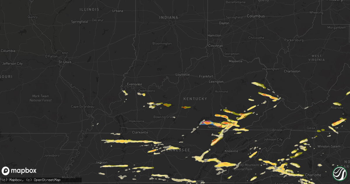
Hail Map in Kentucky on May 8, 2025
Get this storm
May 8 map
$229
one time, instant access
Download today. No call, no setup
Keep the $229
Bought the map and want the full workflow? Apply the entire $229 to a subscription within 7 days. None of it is wasted.
Every map, not just this one
This buys you this map. Subscription and you get every map we run, in the markets you choose from a few cities to whole states to nationwide. Plus real-time alerts the moment a storm fires.
Contact data
Name, contact info, occupancy, even credit band for addresses in the footprint. You go from where it hit to who to call.
Become the source they trust
Unlimited branding weather history reports on demand. You already have the documented answer ready for the property owner, and you are the one who showed up with it.
Property data and RoofTrace estimates
Pull up any address you have got, its value and the exact code rules for that jurisdiction, straight from One Click Code. Then RoofTrace estimates the squares, pitch, and roof value, priced the way you price.
Storm reports in Kentucky
Kentucky
| Date | Description |
|---|---|
| 05/08/20256:57 PM CDT | Social media report of a tree down blocking the westbound lane of ky 476 between flintville and clayhole. Time estimated via radar. |
| 05/08/20256:57 PM CDT | Public and also media shared photos out of mcandrews... Ky showing 2 inch hail. Time estimated by radar. |
| 05/08/20256:50 PM CDT | A public report said 1 inch hail fell at the intersection open fork and bent branch rd. Time estimated from radar. |
| 05/08/20256:13 PM CDT | Picture on social media of a measured 2.5 inch hail stone found at the intersection of ky-194 and ky-1428 between 7:10 and 7:15 pm. |
| 05/08/20256:13 PM CDT | Cumberland gap national historic park made a social media post that the pinnacle road and hwy 988 sections in the park are closed until further notice due to clearing o |
| 05/08/20256:12 PM CDT | Corrects time of previous h825 local em reported estimated ping pong ball sized hail at residence and provided a photo. |
| 05/08/20256:12 PM CDT | Corrects time of previous hail report from boons camp. Picture on social media of a quarter sized hail stone in boons camp. Time estimated via radar. |
| 05/08/20256:10 PM CDT | Social media video of large hailstones falling in emma. Size estimated to be around golf ball. Time estimated via radar. |
| 05/08/20256:10 PM CDT | Social media report of quarter sized hail in middlesboro at 7:10pm. |
| 05/08/20256:00 PM CDT | Corrects previous hail report from 2 sse barboursville. Hail spotted by someone from the public and measured 1 inch. |
| 05/08/20256:00 PM CDT | Picture on social media of hail in the community of fisty. Hail was accumulating on the ground... With stones between quarter and half dollar size visible in the grass. |
| 05/08/20256:00 PM CDT | Social media picture of quarter to half dollar sized hail along south lake drive in prestonsburg. Time provided by poster and corroborated via radar. |
| 05/08/20255:48 PM CDT | Social media picture of half dollar sized hail along lotts creek road in perry county. Time estimated via radar. |
| 05/08/20255:45 PM CDT | Public posted photos of ping pong ball sized hail near the city of cordia. Time estimated by radar. |
| 05/08/20255:45 PM CDT | Report from mping: quarter |
| 05/08/20255:45 PM CDT | Social media report of measured quarter sized hail along upper second creek road in hazard. Timestamp of 6:45pm... Corroborated by radar. |
| 05/08/20255:41 PM CDT | Multiple social media pictures of quarter sized hail near woodland park in hazard. Time estimated via radar. |
| 05/08/20255:38 PM CDT | Social media pictures of quarter sized hailstones in someones hand and videos of small hail piles in gorman hollow in hazard. Time estimated via radar. |
| 05/08/20255:35 PM CDT | Social media report of quarter sized hail along browns fork road in perry county around 6:35 pm. Time corroborated via radar. |
| 05/08/20255:27 PM CDT | Video on social media of large quantities of hail falling in keaton. Quarter sized stones visible on the ground. Time estimated via radar. |
| 05/08/20255:27 PM CDT | Video on social media of lots of hail falling near the intersection of highland park avenue and the cumberland falls highway |
| 05/08/20255:16 PM CDT | Pictures of snapped telephone poles near the 1900 block of ky-225 were relayed from local ham radio operators. Time estimated from radar. |
| 05/08/20255:15 PM CDT | Re-sends previous hail report from bryants store due to iris error message. Pictures on social media of ping pong ball sized hail from 6:15 pm in the little poplar cree |
| 05/08/20255:14 PM CDT | Picture on social media of two very large hailstones near the intersection of e williamsburg street and state highway 478. They are in a womans hand and are 3 fingers w |
| 05/08/20255:07 PM CDT | Picture on social media of very large hail at mile marker 6 on williamsburg st in mccreary county near watters ridge rd. The hail is in someones hand and it is four fin |
| 05/08/20255:06 PM CDT | Social media picture of a few quarter sized hail stones in barbourville amongst piles of smaller hail on the ground. Time provided was 6:06 pm and radar corroborates th |
| 05/08/20255:05 PM CDT | Social media picture of a 2 inch hail stone near ky 700 and jennys branch road ne of whitley city. Time estimated via radar. |
| 05/08/20255:00 PM CDT | Trained spotter reports nickel to quarter sized hail north of whitley city. Time confirmed via radar. |
| 05/08/20255:00 PM CDT | Social media report of at least quarter sized hail breaking windshields along log mountain in bell county around 6pm. |
| 05/08/20255:00 PM CDT | This is the previous hail report from 1 nw davisburg. It is in the wrong spot. The actual report was up the road closer to clear creek springs. Social media report of a |
| 05/08/20254:55 PM CDT | Corrects the previous hail report from 1 nw davisburg. It was in the wrong spot. This report is now in the correct location... Up ky 190 closer to clear creek springs. |
| 05/08/20254:35 PM CDT | Hail larger than quarter size was reported near cutshin along ky 699 south of the 6 to 7 mile markers and hail of various sizes fell along the route to the perry county |
| 05/08/20254:34 PM CDT | A social media report showed a picture of a couple hail stones estimated be the size of golf balls in delta. Time estimated from radar. |
| 05/08/20254:30 PM CDT | Report from mping: golf ball |
| 05/08/20254:23 PM CDT | Social media picture of hail covering the ground north of keavy along 192. Majority of the stones are closer to quarter sized... But a few significantly larger stones a |
| 05/08/20254:20 PM CDT | Picture on social media of piles of melting large hail along michigan avenue in monticello. Some of the storms are at least quarter sized still... And the entirety of t |
| 05/08/20254:20 PM CDT | Hail estimated at quarter size was reported to have fallen near the intersection of ky 1780 and us 421. The event time is radar estimated. |
| 05/08/20254:20 PM CDT | Hail estimated at quarter size was reported to have fallen near the intersection of ky 1780 |
| 05/08/20254:15 PM CDT | Multiple pictures of baseball sized hail in monticello. One such stone was near the intersection of hwy 3285/hwy 776. Time estimated via radar. |
| 05/08/20254:15 PM CDT | Corrects time. Re-sends previous hail report from bryants store due to iris error message. Pictures on social media of ping pong ball sized hail from 5:15 pm in the lit |
| 05/08/20254:13 PM CDT | Pictures on social media of quarter to ping pong ball sized hail in essie. Time estimated via radar. |
| 05/08/20254:12 PM CDT | Picture on social media of a quarter sized hail stone in boons camp. Time estimated via radar. |
| 05/08/20254:12 PM CDT | Multiple reports of broken windows and damaged vinyl siding in monticello from the large hail this evening. At a residence along bob carrender road... There were photos |
| 05/08/20254:12 PM CDT | Pictures on social media of structure damage along cherry street in monticello from the large hail that fell. Multiple broken windows and tattered vinyl siding visible. |
| 05/08/20254:11 PM CDT | A local report indicates 1.00 inch wind near 1 SW Monticello |
| 05/08/20254:11 PM CDT | Large amounts of ping pong ball sized hail reported near the doughboy statue in downtown monticello. Time estimated via radar. |
| 05/08/20254:05 PM CDT | Trained spotter reported estimated golf ball size hail. Time estimated from radar. |
| 05/08/20253:41 PM CDT | Social media picture of golf ball sized hail on jacks fork road off 26. Time estimated via radar. |
| 05/08/20253:36 PM CDT | Delayed social media report of half dollar sized hail in rockholds. Report passed on by skywarn ham network. Time estimated via radar. |
| 05/08/20253:35 PM CDT | Hailstones ranging in size between 1.5 inches and 2.5 inches fell. |
| 05/08/20253:30 PM CDT | A local report indicates 1.00 inch wind near Goldbug |
| 05/08/20253:28 PM CDT | Report from mping: quarter |
| 05/08/20253:15 PM CDT | Social media video of lots of hail falling near the intersection of hooppole creek road and marydell road in eastern laurel county around 4:15 pm. Time confirmed by rad |
| 05/08/20253:06 PM CDT | Public shared video of small hailstones... With larger quarter sized hail embedded. This occurred on ky-225 in trosper near the intersection of number one hollow road. |
| 05/08/20253:05 PM CDT | Public report of 1.00 inch measured hail nw of fourmile... Time estimated via radar. |
| 05/08/20253:03 PM CDT | Social media pictures of at least egg sized hail in trosper around 4pm. The hail broke car windshields. Time estimated to be 4:03pm via radar. |
| 05/08/20253:03 PM CDT | Trained spotter reported half dollar sized hail at the intersection of east jellico road and ky 92. Time estimated via radar. |
| 05/08/20253:02 PM CDT | Public emailed picture of half dollar sized hail. |
| 05/08/20252:54 PM CDT | Public report of golf ball sized hail. |
| 05/08/20252:54 PM CDT | Public report of golf ball sized hail. |
| 05/08/20252:50 PM CDT | Picture of multiple hailstones compared with a penny ne of london. The largest stones are at least double the size of the penny. Time estimated via radar. |
| 05/08/20252:40 PM CDT | Damage to residence home near boxville. Shingle damage along with downspouts and gutters torn away from home. Hvac was turned on its side as well. |
| 05/08/20252:31 PM CDT | A local report indicates 2.00 inch wind near Utica |
| 05/08/20252:31 PM CDT | A local report indicates 1.00 inch wind near 1 ESE Morganfield |
| 05/08/20252:31 PM CDT | Public report of ping pong sized hail. |
| 05/08/20252:27 PM CDT | Public report of quarter sized hail. |
| 05/08/20252:16 PM CDT | Public report of quarter sized hail. |
| 05/08/20251:54 PM CDT | Trained spotter reported ping pong sized hail at the intersection of ky 187 and pine ridge dr. In sw grayson county. |
| 05/08/202512:38 PM CDT | Emergency manager reported golf ball sized hail. |
| 05/08/202512:30 PM CDT | Machine shop in mchenry reported quarter size hail. |
| 05/07/20257:05 PM CDT | Picture on social media of half dollar sized hail in pinsonfork... Ky. Time estimated via radar. |
| 05/07/20257:03 PM CDT | Social media picture of a measured 1 inch hailstone along upper blackberry road southwest of ransom... Ky. Time estimated via radar. |
| 05/07/20257:00 PM CDT | Social media report of hail along riley branch road... Near flint ridge cemetery. Mostly smaller stones... But a couple of quarters mixed in. Time provided by reporter. |
| 05/07/20257:00 PM CDT | A picture of estimated golf ball sized hail was sent to the office from belfry. Time estimated from radar. |
All States Impacted by Hail Map on May 8, 2025
Cities Impacted by Hail Map on May 8, 2025
- Bristol, FL
- Eastpoint, FL
- Rio Hondo, TX
- South Padre Island, TX
- Menard, TX
- Brady, TX
- Marathon, TX
- Fort Stockton, TX
- East Prairie, MO
- Gleason, TN
- Centertown, KY
- Beaver Dam, KY
- McHenry, KY
- McKenzie, TN
- Henry, TN
- Paris, TN
- Dryden, TX
- Eldorado, IL
- Raleigh, IL
- Springville, TN
- Mansfield, TN
- Register, GA
- Metter, GA
- Big Sandy, TN
- Sikeston, MO
- Brooklet, GA
- Pembroke, GA
- Cromwell, KY
- Horse Branch, KY
- Stewart, TN
- Waverly, TN
- Statesboro, GA
- Martin, TN
- Sharon, TN
- Fillmore, IN
- Cloverdale, IN
- Greencastle, IN
- Henderson, KY
- Robards, KY
- Sylvania, GA
- Harrisburg, IL
- Tennessee Ridge, TN
- Erin, TN
- Owensboro, KY
- Calhoun, KY
- Bertrand, MO
- Charleston, MO
- Pontotoc, MS
- Equality, IL
- Savannah, GA
- Hardeeville, SC
- Morgantown, KY
- Dresden, TN
- Ellabell, GA
- Tupelo, MS
- Belden, MS
- Comstock, TX
- Pinson, TN
- Junction, IL
- Morganfield, KY
- Puryear, TN
- Bluffton, SC
- Okatie, SC
- Herod, IL
- Caneyville, KY
- Leitchfield, KY
- Brownsville, KY
- Utica, KY
- Uniontown, KY
- Port Wentworth, GA
- Blue Springs, MS
- Henderson, TN
- Beech Bluff, TN
- Buchanan, TN
- Bee Spring, KY
- Clarkson, KY
- Waverly, KY
- Clay, KY
- Williamsburg, KY
- Jacks Creek, TN
- Midway, GA
- Reagan, TN
- Luray, TN
- Huron, TN
- Vanleer, TN
- McEwen, TN
- Plantersville, MS
- Bloomingdale, GA
- Hardyville, KY
- Canmer, KY
- Greensburg, KY
- Rutherfordton, NC
- Lake Lure, NC
- Mill Spring, NC
- Siler, KY
- Riceboro, GA
- Fulton, MS
- Mooreville, MS
- Leicester, NC
- Cumberland Furnace, TN
- Enville, TN
- Hot Springs, NC
- Donna, TX
- Okolona, MS
- Pooler, GA
- Mantachie, MS
- Hohenwald, TN
- Lexington, TN
- Sardis, TN
- Scotts Hill, TN
- Decaturville, TN
- Bath Springs, TN
- Charlotte, TN
- Nettleton, MS
- Pineville, KY
- Barbourville, KY
- Trosper, KY
- Weslaco, TX
- Dickson, TN
- Mercedes, TX
- Richmond Hill, GA
- Fort Stewart, GA
- Summertown, TN
- Guyton, GA
- Drakesboro, KY
- Central City, KY
- White Bluff, TN
- Ashland City, TN
- Union Mills, NC
- Mount Pleasant, TN
- Rockholds, KY
- Hendersonville, NC
- Kilmichael, MS
- Medon, TN
- Asheville, NC
- Alexander, NC
- Franklin, TN
- Marion, NC
- Fourmile, KY
- Twin City, GA
- Crossville, TN
- Pikeville, TN
- Marianna, FL
- Fletcher, NC
- Clifton, TN
- Linden, TN
- Nebo, NC
- Brentwood, TN
- Campbellsville, KY
- Eupora, MS
- Mathiston, MS
- Lancing, TN
- Winter Haven, FL
- Flat Lick, KY
- Wilkesboro, NC
- Fairview, NC
- Morganton, NC
- Amory, MS
- Hilham, TN
- Celina, TN
- Rockport, KY
- Edcouch, TX
- Santa Rosa, TX
- Laredo, TX
- Ferguson, NC
- Boomer, NC
- Maben, MS
- Pheba, MS
- Starkville, MS
- Swannanoa, NC
- Nashville, TN
- Walker, KY
- Stewart, MS
- French Camp, MS
- Quemado, TX
- Allons, TN
- Old Fort, NC
- Woodbine, KY
- Townsend, GA
- Corbin, KY
- Black Mountain, NC
- Smithville, MS
- Lynnville, TN
- Waynesboro, TN
- San Ygnacio, TX
- Auburndale, FL
- Artemus, KY
- Bremen, KY
- Harlingen, TX
- Antioch, TN
- Whites Creek, TN
- Madison, TN
- Bryants Store, KY
- Moravian Falls, NC
- Robbins, TN
- Somerset, KY
- Portal, GA
- Culleoka, TN
- Hudson, NC
- Granite Falls, NC
- Beverly, KY
- Stoney Fork, KY
- Helton, KY
- Manchester, KY
- Arlington, KY
- Clinton, KY
- Toone, TN
- Bolivar, TN
- Crystal City, TX
- Albany, KY
- Alpha, KY
- Weir, MS
- Bardwell, KY
- Garfield, GA
- Warbranch, KY
- Apopka, FL
- Mozelle, KY
- Roark, KY
- Ocoee, FL
- Essie, KY
- Stinnett, KY
- Big Creek, KY
- Hyden, KY
- London, KY
- Bostic, NC
- Monticello, KY
- Bimble, KY
- Marble, NC
- Murphy, NC
- Huntsville, TN
- Greenwood Springs, MS
- Byrdstown, TN
- Detroit, AL
- Hornsby, TN
- Bethel Springs, TN
- Hebbronville, TX
- Kingston Springs, TN
- Pegram, TN
- Zapata, TX
- Eagle Pass, TX
- Tremont, MS
- Lewisburg, TN
- Hermitage, TN
- Joelton, TN
- West Point, MS
- Columbus, MS
- Centerville, TN
- Santa Fe, TN
- Williamsport, TN
- Duck River, TN
- Primm Springs, TN
- Orlando, FL
- Keavy, KY
- Lenoir, NC
- Mount Juliet, TN
- Lawrenceburg, TN
- Taylorsville, NC
- Pioneer, TN
- Forest City, NC
- Beaverton, AL
- Sulligent, AL
- Burkesville, KY
- Gerton, NC
- Chappell, KY
- Jackson, TN
- Valdese, NC
- Douglas, GA
- Lebanon, TN
- Old Hickory, TN
- La Vergne, TN
- Whitleyville, TN
- Wartburg, TN
- Guerra, TX
- Connelly Springs, NC
- Guin, AL
- Hamilton, AL
- Ethridge, TN
- Tazewell, TN
- North Wilkesboro, NC
- Roaring River, NC
- Watertown, TN
- Armstrong, TX
- Yeaddiss, KY
- Wooton, KY
- Lily, KY
- Lascassas, TN
- Murfreesboro, TN
- Newcomb, TN
- Alexandria, TN
- Liberty, TN
- Auburntown, TN
- Smyrna, TN
- Nolensville, TN
- Gray, KY
- Hickory, NC
- Brilliant, AL
- Heidrick, KY
- Winfield, AL
- Fort Gay, WV
- La Follette, TN
- Haysi, VA
- Big Rock, VA
- Breaks, VA
- Whitley City, KY
- Calvin, KY
- Milton, TN
- Edgewater, FL
- New Smyrna Beach, FL
- Ellenboro, NC
- Mooresboro, NC
- Hiddenite, NC
- Pisgah Forest, NC
- Darien, GA
- Nicholls, GA
- West Green, GA
- Hamptonville, NC
- Stafford, VA
- Winfield, TN
- Gotha, FL
- Stearns, KY
- Dowelltown, TN
- Jellico, TN
- Goliad, TX
- Casar, NC
- Genoa, WV
- Wayne, WV
- Shelby, NC
- Lawndale, NC
- Carrizo Springs, TX
- Oak Hill, FL
- Encino, TX
- Middlesboro, KY
- Elkfork, KY
- Mills River, NC
- Alma, GA
- Horse Shoe, NC
- East Lynn, WV
- Dunlow, WV
- Kiahsville, WV
- Sandy Hook, KY
- Isonville, KY
- West Liberty, KY
- Martha, KY
- Keaton, KY
- Flatgap, KY
- Ranger, WV
- Ethelsville, AL
- Baker, FL
- Vale, NC
- Arden, NC
- Cashiers, NC
- Highlands, NC
- Batesville, TX
- Baxley, GA
- Miracle, KY
- Lynn, AL
- Nauvoo, AL
- Savannah, TN
- Cherryville, NC
- Roma, TX
- Andrews, NC
- Pine Knot, KY
- Rio Grande City, TX
- Lincolnton, NC
- Spindale, NC
- Stuart, VA
- Bassett, VA
- Henry, VA
- Harts, WV
- Branchland, WV
- Chapmanville, WV
- Blaine, KY
- Sitka, KY
- Stambaugh, KY
- College Grove, TN
- Arrington, TN
- Sapphire, NC
- Osteen, FL
- Hazard, KY
- Laurel Hill, FL
- Carrollton, AL
- Reform, AL
- Grover, NC
- Purlear, NC
- Millers Creek, NC
- Mims, FL
- Glenville, NC
- Sunbright, TN
- Dilley, TX
- Sanford, FL
- Patrick Springs, VA
- Scalf, KY
- Warren, MA
- West Brookfield, MA
- Cotulla, TX
- Critz, VA
- Spencer, VA
- Dobson, NC
- Elkin, NC
- Mount Airy, NC
- Sassafras, KY
- Big Creek, WV
- McGrady, NC
- Lowmansville, KY
- Louisa, KY
- Hays, NC
- Prestonsburg, KY
- Carrie, KY
- Hindman, KY
- Santa Elena, TX
- Sweetwater, TN
- Philadelphia, TN
- Big Wells, TX
- Asherton, TX
- Catarina, TX
- Lake Toxaway, NC
- Ten Mile, TN
- Andalusia, AL
- Florala, AL
- Spring City, TN
- Martinsville, VA
- Frakes, KY
- Rocky Mount, VA
- Lutts, TN
- Collinwood, TN
- Jacksonville, GA
- Glade Hill, VA
- Kings Mountain, NC
- Guntersville, AL
- Penhook, VA
- Ridgeway, VA
- Garciasville, TX
- Danville, WV
- Turtle Creek, WV
- Hewett, WV
- Pecks Mill, WV
- Lake, WV
- Yolyn, WV
- Chatham, VA
- Emmalena, KY
- Longwood, FL
- Pulaski, TN
- Petersburg, TN
- Frankewing, TN
- Madisonville, TN
- Vonore, TN
- Brevard, NC
- China Grove, NC
- Union Grove, AL
- Prospect, TN
- Ardmore, TN
- Grulla, TX
- Greenback, TN
- Maryville, TN
- Tallassee, TN
- Gastonia, NC
- Niota, TN
- Fayetteville, TN
- Mission, TX
- Edinburg, TX
- Jeffrey, WV
- Clothier, WV
- Amherstdale, WV
- River, KY
- Cumberland Gap, TN
- Stoneville, NC
- Iron City, TN
- Westpoint, TN
- Eskdale, WV
- Ewing, VA
- Harrogate, TN
- Uvalda, GA
- Kannapolis, NC
- Landis, NC
- Lyons, GA
- Caryville, TN
- Opp, AL
- Kimberly, WV
- Powellton, WV
- Montgomery, WV
- Kincaid, WV
- Robson, WV
- Bim, WV
- Ulysses, KY
- Pikeville, KY
- Decatur, TN
- Kinston, AL
- Gallagher, WV
- Robbinsville, NC
- Boons Camp, KY
- Paintsville, KY
- Vidalia, GA
- Stanleytown, VA
- Delmita, TX
- Chesnee, SC
- Elba, AL
- Houston, MS
- Woodland, MS
- Danbury, NC
- Walnut Cove, NC
- East Point, KY
- Assaria, KS
- Salina, KS
- Lindsborg, KS
- Athens, TN
- Dellrose, TN
- Rockwell, NC
- Loudon, TN
- Allen, KY
- Lake Mary, FL
- Ackerman, MS
- Mcallen, TX
- Clayhole, KY
- Jackson, KY
- Varney, KY
- Kimper, KY
- Mocksville, NC
- Spencer, TN
- Linefork, KY
- Whitesburg, KY
- Hallie, KY
- Cornettsville, KY
- Jack, AL
- Evensville, TN
- Garner, KY
- Leburn, KY
- Wharton, WV
- Defuniak Springs, FL
- Crab Orchard, TN
- Maitland, FL
- Winter Park, FL
- Inez, KY
- Debord, KY
- Sidney, KY
- Canada, KY
- McAndrews, KY
- Pinsonfork, KY
- Stone, KY
- Ransom, KY
- Pharr, TX
- Rockwood, TN
- Deland, FL
- Mulberry, TN
- Gordo, AL
- Cosby, TN
- Traphill, NC
- Sneedville, TN
- Smithville, TN
- Oneida, TN
- Cyclone, WV
- Brundidge, AL
- Helenwood, TN
- Teaberry, KY
- Beaver, KY
- McDowell, KY
- Harold, KY
- State Road, NC
- Ronda, NC
- Belvidere, TN
- Kelso, TN
- Englewood, TN
- Clover, SC
- Hartford, TN
- Fontana Dam, NC
- Americus, GA
- San Juan, TX
- Alamo, TX
- Fayetteville, WV
- Oceana, WV
- Naoma, WV
- Arnett, WV
- Bolt, WV
- Ariton, AL
- Fieldale, VA
- Gainesboro, TN
- Fowlerton, TX
- Tilden, TX
- York, SC
- Del Rio, TN
- Baxter, TN
- Buffalo Valley, TN
- Bloomington Springs, TN
- Chestnut Mound, TN
- Granville, TN
- Elmwood, TN
- Grethel, KY
- Enterprise, AL
- New Brockton, AL
- Vest, KY
- Daytona Beach, FL
- Rock Hill, SC
- Progreso, TX
- Sandy Ridge, NC
- Java, VA
- Nathalie, VA
- Salem, VA
- Daleville, VA
- Roanoke, VA
- Troutville, VA
- Eutaw, AL
- Catawba, VA
- Winchester, TN
- Tellico Plains, TN
- Wirtz, VA
- Moneta, VA
- Cuthbert, GA
- Morris, GA
- Grundy, VA
- Lumpkin, GA
- Cloverdale, VA
- Berry, AL
- Smyrna, SC
- Rose Hill, VA
- Knoxville, AL
- Albemarle, NC
- Locust, NC
- Smithville, GA
- Halifax, VA
- Denton, NC
- Freer, TX
- Calliham, TX
- Lawsonville, NC
- Vienna, GA
- Mount Vernon, KY
- Ralph, AL
- Sherwood, TN
- Axton, VA
- Logan, WV
- Speedwell, TN
- Plains, GA
- Loretto, TN
- South Pittsburg, TN
- Westfield, NC
- Callands, VA
- Fort Mill, SC
- Blue Ridge, VA
- Advance, NC
- Smiths Grove, KY
- Glasgow, KY
- Park City, KY
- Moundville, AL
- Akron, AL
- San Diego, TX
- Belfry, KY
- Williamson, WV
- Stopover, KY
- Phelps, KY
- Phyllis, KY
- Freeburn, KY
- Majestic, KY
- Matewan, WV
- Flintville, TN
- Pinehurst, GA
- Candler, NC
- Canton, NC
- McCarr, KY
- Fosters, AL
- Grandview, TN
- Arab, AL
- Woodville, AL
- New Hope, AL
- Bastian, VA
- Rocky Gap, VA
- Narrows, VA
- Somerville, AL
- Asheboro, NC
- Star, NC
- Troy, NC
- Grant, AL
- Hollywood, AL
- Fackler, AL
- Hartselle, AL
- Charlotte, NC
- Stevenson, AL
- Waxhaw, NC
- Scottsboro, AL
- Falkville, AL
- Arjay, KY
- Bankston, AL
- Fayette, AL
- New London, NC
- Catawba, SC
- Thurmond, NC
- Collinsville, VA
- Reliance, TN
- Carthage, NC
- Harmony, NC
- Union Grove, NC
- Leslie, GA
- Lexington, VA
- Glasgow, VA
- Natural Bridge, VA
- Chattanooga, TN
- Alice, TX
- Lancaster, SC
- East Bernstadt, KY
- Orange Grove, TX
- Dwale, KY
- Kingston, GA
- Stanville, KY
- Guild, TN
- Whitwell, TN
- Jasper, TN
- Lookout Mountain, TN
- Cartersville, GA
- White, GA
- Trenton, GA
- Tuckasegee, NC
- Gaylesville, AL
- Sewanee, TN
- Bishop, TX
- Robstown, TX
- Jonesville, VA
- Penitas, TX
- Sullivan City, TX
- Cleveland, TN
- Apison, TN
- Ringgold, GA
- Cohutta, GA
- Rossville, GA
- Cedar Bluff, AL
- Morris Chapel, TN
- Wildwood, GA
- Scaly Mountain, NC
- Corpus Christi, TX
- Columbus, NC
- Tryon, NC
- San Benito, TX
- La Feria, TX
- Hi Hat, KY
- Rock Island, TN
- Pippa Passes, KY
- Waterloo, AL
- Newburgh, IN
- Parrottsville, TN
- Union, SC
- Greeneville, TN
- Huntland, TN
- Carlisle, SC
- Whitmire, SC
- Sequatchie, TN
- Chester, SC
- Sharon, SC
- Rome, GA
- Pineville, NC
- Bulls Gap, TN
- Mosheim, TN
- Blair, SC
- McConnells, SC
- Sparta, GA
- Milledgeville, GA
- Gray, GA
- Haddock, GA
- Edgefield, SC
- Johnston, SC
- Eatonton, GA
- Ridge Spring, SC
- Ward, SC
- Ridgeway, SC
- Liberty Hill, SC
- Camden, SC
- Monetta, SC
- Madison, GA
- Cassatt, SC
- North Augusta, SC
- Clarks Hill, SC
- Bethune, SC
- Graniteville, SC
- White Plains, GA
- Greensboro, GA
- Bishopville, SC
- Trenton, SC
- Crawfordville, GA
- Berlin, MD
- Aiken, SC
- Lovely, KY
- Holden, WV
- Lenore, WV
- Dingess, WV
- Stollings, WV
- Warrenville, SC
- Batesburg, SC
- Bybee, TN
- Newport, TN
- Abbeville, SC
- Calhoun Falls, SC
- Florence, SC
- Salley, SC
- Williston, SC
- Windsor, SC
- Blackville, SC
- Springfield, SC
- Marion, SC
- Mullins, SC
- Nichols, SC
- Bamberg, SC
- Green Sea, SC
- Branchville, SC
- Smoaks, SC
- Reevesville, SC
- Ware, MA
- West Warren, MA
- Cottageville, SC
- New Tazewell, TN
- Cottage Grove, TN
- Smilax, KY
- Cana, VA
- Ararat, VA
- Claudville, VA
- Meadows Of Dan, VA
- Vinton, VA
- Buena Vista, VA
- Bronston, KY
- Wendover, KY
- Viper, KY
- Slemp, KY
- Tutor Key, KY
- Tomahawk, KY
- Hagerhill, KY


