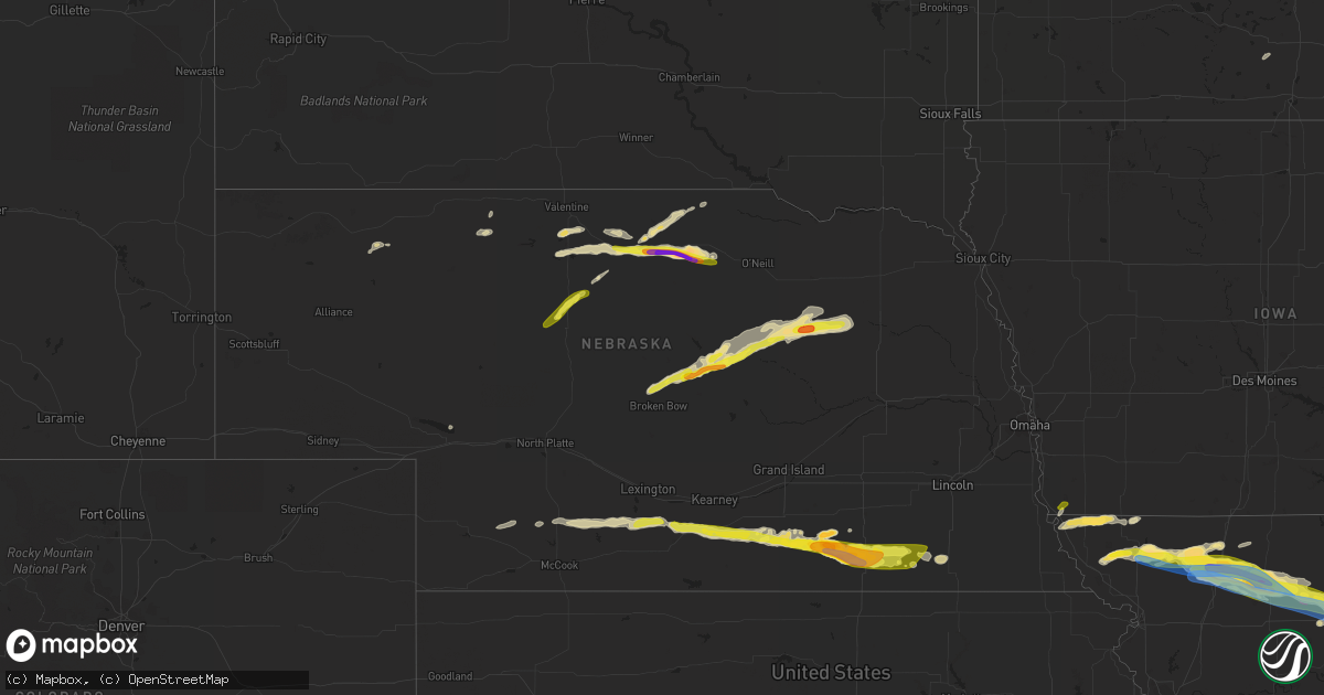
Hail Map in Nebraska on May 6, 2023
Get this storm
May 6 map
$229
one time, instant access
Download today. No call, no setup
Keep the $229
Bought the map and want the full workflow? Apply the entire $229 to a subscription within 7 days. None of it is wasted.
Every map, not just this one
This buys you this map. Subscription and you get every map we run, in the markets you choose from a few cities to whole states to nationwide. Plus real-time alerts the moment a storm fires.
Contact data
Name, contact info, occupancy, even credit band for addresses in the footprint. You go from where it hit to who to call.
Become the source they trust
Unlimited branding weather history reports on demand. You already have the documented answer ready for the property owner, and you are the one who showed up with it.
Property data and RoofTrace estimates
Pull up any address you have got, its value and the exact code rules for that jurisdiction, straight from One Click Code. Then RoofTrace estimates the squares, pitch, and roof value, priced the way you price.
Storm reports in Nebraska
Nebraska
| Date | Description |
|---|---|
| 05/06/20236:28 PM CDT | Few quarter size hailstones but mostly dime size. |
| 05/06/20236:25 PM CDT | Public reports three inch hail... Golf ball hail... And quarter sized with accumulation of at least 2 inches in depth of hail. |
| 05/06/20236:00 PM CDT | Quarter sized hail near bassett via social media. |
| 05/06/20235:49 PM CDT | Golf ball to ping pong ball sized hail reported. |
| 05/06/20235:34 PM CDT | Public reports landspout touchdown near stockbille. |
| 05/06/20235:30 PM CDT | Ainsworth fire personnel reported pea to quarter sized hail near the sw corner of ainsworth. |
| 05/06/20234:50 PM CDT | Public reports brief land spout near hayes center. |
| 05/06/20236:10 AM CDT | Delayed public report of ping pong ball sized hail. |
| 05/06/20234:15 AM CDT | Time and hail size estimated. |
| 05/06/20234:14 AM CDT | Nickel to quarter sized hail. Report received via social media. |
| 05/06/20234:02 AM CDT | Photo via facebook from 8n ord of hail up to the size of half dollars. Time est. From radar. |
| 05/06/20233:50 AM CDT | Hail up to ping pong ball size was reported... Largest hail occurred around 350am. |
| 05/06/20233:45 AM CDT | Hail up to quarter size was reported... Ground was still partially white after sunrise. Time est. From radar. |
| 05/06/20233:30 AM CDT | Time and hail size estimated. |
| 05/06/20233:25 AM CDT | Enough hail fell to cover the ground. Corrected for time. |
| 05/06/20233:15 AM CDT | Enough hail fell to cover the ground. |
| 05/05/20239:48 PM CDT | Report from mping: quarter |
| 05/05/20239:48 PM CDT | Relayed via emergency management. |
| 05/05/20238:59 PM CDT | A local report indicates 1.75 inch wind near CARLETON |
| 05/05/20238:57 PM CDT | Photos via facebook of golf ball size hail. Lasted 6-10 minutes. |
| 05/05/20238:57 PM CDT | Trained spotter reported hail ranging in size from quarters to golfballs. The large hail lasted about three minutes. |
| 05/05/20238:55 PM CDT | Delayed report via twitter. Time estimated from radar. |
| 05/05/20238:53 PM CDT | Photo via facebook of about tennis ball size hail along hwy 4 west of davenport. Time estimated from radar. |
| 05/05/20238:45 PM CDT | Photo via facebook of about tennis ball size hail south of edgar. Time estimated from radar. |
| 05/05/20238:35 PM CDT | A local report indicates 1.75 inch wind near EDGAR |
| 05/05/20238:34 PM CDT | Photo via twitter of hailstone about two and a half quarters in diameter. Time estimated from radar and nearby reports. |
| 05/05/20238:31 PM CDT | Picture of several golf ball size hailstones via facebook. Time estimated from radar. |
| 05/05/20238:25 PM CDT | Emergency manager reported half dollar sized hail. |
| 05/05/20238:13 PM CDT | Photo via facebook. |
| 05/05/20237:50 PM CDT | Public reports nickel and quarter sized hail around. |
| 05/05/20237:14 PM CDT | Public estimates 60 mph winds. |
| 05/05/20237:13 PM CDT | A local report indicates 1.00 inch wind near 4 S MINDEN |
| 05/05/20237:00 PM CDT | Social media report of hail ranging in size from peas to quarters. |
| 05/05/20237:00 PM CDT | Public reports quarter sized hail near mm 161 and mm 162 on highway 83 n. |
All States Impacted by Hail Map on May 6, 2023
Cities Impacted by Hail Map on May 6, 2023
- Gonzales, LA
- Denham Springs, LA
- Saint Amant, LA
- Sorrento, LA
- Darrow, LA
- Prairieville, LA
- Baton Rouge, LA
- Geismar, LA
- French Settlement, LA
- Saint Gabriel, LA
- Livingston, LA
- Maurepas, LA
- Springfield, LA
- Gramercy, LA
- Garyville, LA
- Ponchatoula, LA
- La Place, LA
- Holden, LA
- Hammond, LA
- Madisonville, LA
- Donaldsonville, LA
- Paulina, LA
- Convent, LA
- Vacherie, LA
- Mount Airy, LA
- Saint James, LA
- Lutcher, LA
- Edgard, LA
- Hahnville, LA
- Reserve, LA
- Mandeville, LA
- Saint Rose, LA
- Luling, LA
- Metairie, LA
- Destrehan, LA
- Kenner, LA
- Ama, LA
- Covington, LA
- Abita Springs, LA
- Norco, LA
- New Orleans, LA
- Boutte, LA
- Lacombe, LA
- Westwego, LA
- Marrero, LA
- Harvey, LA
- Gretna, LA
- Chalmette, LA
- Arabi, LA
- Belle Chasse, LA
- Meraux, LA
- Slidell, LA
- Pearl River, LA
- White Castle, LA
- Carville, LA
- Picayune, MS
- Robert, LA
- Belle Rose, LA
- Paradis, LA
- Violet, LA
- Des Allemands, LA
- Braithwaite, LA
- Saint Bernard, LA
- Thibodaux, LA
- Gulfport, MS
- Stennis Space Center, MS
- Pass Christian, MS
- Kiln, MS
- Diamondhead, MS
- Waveland, MS
- Bay Saint Louis, MS
- Pearlington, MS
- Long Beach, MS
- Raceland, LA
- Lafitte, LA
- Cut Off, LA
- Port Sulphur, LA
- Lockport, LA
- Barataria, LA
- Frankford, MO
- Louisiana, MO
- Bowling Green, MO
- Pleasant Hill, IL
- Rockport, IL
- Clarksville, MO
- Nebo, IL
- Kampsville, IL
- Pearl, IL
- White Hall, IL
- Eldred, IL
- Carrollton, IL
- Franklin, LA
- Ethel, MO
- Bucklin, MO
- Ridgeway, MO
- Princeton, MO
- Theriot, LA
- Evergreen, LA
- Plaucheville, LA
- Morrow, LA
- Ville Platte, LA
- Washington, LA
- Moberly, MO
- Madison, MO
- Holliday, MO
- Stoutsville, MO
- Paris, MO
- Brookfield, MO
- Folsom, LA
- Green Castle, MO
- New London, MO
- Shelbina, MO
- Loreauville, LA
- Jeanerette, LA
- New Iberia, LA
- Cairo, MO
- Macon, MO
- Oakdale, LA
- Rutledge, MO
- Memphis, MO
- Callao, MO
- Atlanta, MO
- New Cambria, MO
- New Boston, MO
- Elmer, MO
- La Plata, MO
- Gibbs, MO
- Monroe City, MO
- Kirksville, MO
- Perry, MO
- Baldwin, LA
- Ashburn, MO
- Center, MO
- Curryville, MO
- New Canton, IL
- Kinderhook, IL
- Novinger, MO
- Auxvasse, MO
- Columbia, MO
- Bunkie, LA
- Hamburg, IA
- Farragut, IA
- Riverton, IA
- Peru, NE
- Watson, MO
- Rock Port, MO
- Tarkio, MO
- Westboro, MO
- Hamlin, TX
- Stamford, TX
- Valera, TX
- Talpa, TX
- Coleman, TX
- Skidmore, MO
- Maryville, MO
- Throckmorton, TX
- Aspermont, TX
- Old Glory, TX
- Rule, TX
- Novice, TX
- Bangs, TX
- Santa Anna, TX
- Brownwood, TX
- Elmo, MO
- Clyde, TX
- Miles, TX
- Ballinger, TX
- Norton, TX
- Seymour, TX
- Rochester, TX
- O'Brien, TX
- Rotan, TX
- Sweetwater, TX
- Roby, TX
- Barnard, MO
- Conception Junction, MO
- Burlington Junction, MO
- Clearmont, MO
- Blanchard, IA
- Hopkins, MO
- Burkett, TX
- Haskell, TX
- Clyde, MO
- Conception, MO
- Stanberry, MO
- Benjamin, TX
- Baird, TX
- Cross Plains, TX
- Johnstown, NE
- Ainsworth, NE
- Long Pine, NE
- Bassett, NE
- Albany, MO
- Guilford, MO
- Cody, NE
- Wanblee, SD
- Simmesport, LA
- Kyle, SD
- Howes, SD
- Morgan City, LA
- Wounded Knee, SD
- Batesland, SD
- Martin, SD
- Allen, SD
- Porcupine, SD
- Dulac, LA
- Chauvin, LA
- Montegut, LA
- Midland, SD
- Raymond, IL
- Carlinville, IL
- Nilwood, IL
- Waggoner, IL
- Girard, IL
- Morganza, LA
- New Roads, LA
- Waseca, MN
- New Richland, MN
- Enning, SD
- White Owl, SD
- Gibson, LA
- Melville, LA
- Lettsworth, LA
- Palmetto, LA
- Batchelor, LA
- Rushville, NE
- Lakeland, LA
- Oscar, LA
- Erwinville, LA
- Jarreau, LA
- Palisade, NE
- Wauneta, NE
- Hayes Center, NE
- Bingham, IL
- Fillmore, IL
- Ravenwood, MO
- Maitland, MO
- Mound City, MO
- Valentine, NE
- Cisne, IL
- Mount Erie, IL
- Harvel, IL
- Milesville, SD
- Belle Fourche, SD
- Cherry Creek, SD
- Goodhue, MN
- Litchfield, IL
- Golden Meadow, LA
- Grand Isle, LA
- Livonia, LA
- Ventress, LA
- Newell, SD
- Port Allen, LA
- Hillsboro, IL
- Irving, IL
- Flora, IL
- Shipman, IL
- Gillespie, IL
- Schriever, LA
- Ramsey, IL
- Hulett, WY
- Bunker Hill, IL
- Medora, IL
- Mount Olive, IL
- Chesterfield, IL
- Benld, IL
- Altamont, IL
- Cowden, IL
- Saint Elmo, IL
- Beecher City, IL
- Rinard, IL
- Clay City, IL
- Coffeen, IL
- Witt, IL
- New Underwood, SD
- Rockbridge, IL
- Butler, IL
- Kane, IL
- Taylor Springs, IL
- Sawyerville, IL
- Fieldon, IL
- West Salem, IL
- Nokomis, IL
- Oconee, IL
- Staunton, IL
- Walshville, IL
- Mulberry Grove, IL
- Vandalia, IL
- Mason, IL
- Brownstown, IL
- Albany, TX
- Sylvester, TX
- Newport, NE
- Darlington, MO
- McCaulley, TX
- Sacred Heart, MN
- Clara City, MN
- Raymond, MN
- Renville, MN
- Prinsburg, MN
- Willmar, MN
- Stuart, NE
- Bethany, MO
- McFall, MO
- New Hampton, MO
- Pattonsburg, MO
- Coffey, MO
- Thedford, NE
- Seneca, NE
- May, TX
- Davidson, OK
- Elsmere, NE
- Rising Star, TX
- Gilman City, MO
- Frederick, OK
- Jameson, MO
- Jamesport, MO
- Hollister, OK
- Gallatin, MO
- Trenton, MO
- King City, MO
- Loveland, OK
- Abilene, TX
- Laredo, MO
- Indiahoma, OK
- Chattanooga, OK
- Cache, OK
- Faxon, OK
- Snyder, OK
- Early, TX
- Blanket, TX
- Lawton, OK
- Chillicothe, MO
- Chula, MO
- Linneus, MO
- Wheeling, MO
- Browning, MO
- Humphreys, MO
- Purdin, MO
- Galt, MO
- Meadville, MO
- Laclede, MO
- Blue Hill, NE
- Glenvil, NE
- Lawrence, NE
- Fairfield, NE
- Cisco, TX
- Deweese, NE
- Edgar, NE
- Ong, NE
- Nelson, NE
- Oak, NE
- Davenport, NE
- Brookesmith, TX
- Winigan, MO
- Bruning, NE
- Shickley, NE
- Carleton, NE
- Stephenville, TX
- Bluff Dale, TX
- Tolar, TX
- Lipan, TX
- Santo, TX
- Granbury, TX
- Weatherford, TX
- Belvidere, NE
- Deshler, NE
- Hebron, NE
- Daykin, NE
- Ohiowa, NE
- Western, NE
- Alexandria, NE
- Tobias, NE
- Gilead, NE
- Fairbury, NE
- Plymouth, NE
- Jansen, NE
- De Witt, NE
- Hico, TX
- Walnut Springs, TX
- Marceline, MO
- Excello, MO
- Jacksonville, MO
- Bevier, MO
- Mount Sterling, IA
- Bonaparte, IA
- Keosauqua, IA
- West Burlington, IA
- Danville, IA
- Middletown, IA
- Burlington, IA
- Wever, IA
- Arbela, MO
- Luray, MO
- Kahoka, MO
- Glen Rose, TX
- Rainbow, TX
- Douds, IA
- Birmingham, IA
- Milton, IA
- Cantril, IA
- Stockport, IA
- Selma, IA
- Eldon, IA
- Floris, IA
- Bloomfield, IA
- Anabel, MO
- Clarence, MO
- Godley, TX
- Cleburne, TX
- Joshua, TX
- Nemo, TX
- Lentner, MO
- Batavia, IA
- Libertyville, IA
- Fairfield, IA
- Rio Vista, TX
- Blum, TX
- Covington, TX
- Grandview, TX
- Itasca, TX
- Attica, IN
- Williamsport, IN
- Perrysville, IN
- Covington, IN
- Alvarado, TX
- Burleson, TX
- Mansfield, TX
- Lillian, TX
- Venus, TX
- Midlothian, TX
- Milford, TX
- Italy, TX
- Waxahachie, TX
- Maypearl, TX
- Forreston, TX
- Waurika, OK
- Ryan, OK
- Petrolia, TX
- Byers, TX
- Breckenridge, TX
- Wabasha, MN
- Ideal, SD
- Drakesville, IA
- Moran, TX
- Henrietta, TX
- Bellevue, TX
- Bowie, TX
- Sturgis, SD
- Ozona, TX
- Wood Lake, NE
- Springview, NE
- Independence, WI
- Whitehall, WI
- Hanley Falls, MN
- Granite Falls, MN
- Woodson, TX
- Atkinson, NE
- Vale, SD
- Zumbrota, MN
- Wanamingo, MN
- Munday, TX
- Knox City, TX
- Crowell, TX
- Nocona, TX
- Ringgold, TX
- Blomkest, MN
- Mazeppa, MN
- Lake City, MN
- Vernon, TX
- Beatrice, NE
- Hennepin, OK
- Holliday, TX
- Baker, LA
- Naper, NE
- Avoca, TX
- Wichita Falls, TX
- Olney, TX
- Wood, SD
- Winner, SD
- Winnett, MT
- Farnam, NE
- Eustis, NE
- Bertrand, NE
- Smithfield, NE
- Curtis, NE
- Elwood, NE
- Stockville, NE
- Moorefield, NE
- Alma, WI
- Holstein, NE
- Loomis, NE
- Holdrege, NE
- Clay Center, NE
- Roseland, NE
- Bladen, NE
- Minden, NE
- Campbell, NE
- Wilcox, NE
- Funk, NE
- Ayr, NE
- Axtell, NE
- Hildreth, NE
- Sutton, NE
- Elgin, OK
- Dublin, TX
- Martinsville, MO
- Newcastle, TX
- Comanche, TX
- De Leon, TX
- Goree, TX
- Jacksboro, TX
- Mills, NE
- Archer City, TX
- Windthorst, TX
- Red Wing, MN
- Hawley, TX
- Anson, TX
- Gregory, SD
- Hamill, SD
- Oklaunion, TX
- Arapahoe, NE
- Geneva, NE
- Ogallala, NE
- Wasta, SD
- Arcadia, WI
- Gentry, MO
- Loving, TX
- Millville, MN
- Scotland, TX
- Lake Lillian, MN
- Merkel, TX
- Nelson, WI
- Maywood, NE
- Ringling, OK
- Loco, OK
- Harrold, TX
- Milan, MO
- Graham, MO
- Mondovi, WI
- Lueders, TX
- Glynn, LA
- Kenyon, MN
- Sidney, TX
- Shelbyville, MO
- Lockridge, IA
- Bethel, MO
- Ennis, TX
- Palmer, TX
- Ferris, TX
- Red Oak, TX
- Cedar Hill, TX
- Remington, IN
- Wolcott, IN
- Fowler, IN
- Reynolds, IN
- Kemp, TX
- Scurry, TX
- Rosser, TX
- Pittsburg, OK
- Stuart, OK
- Kiowa, OK
- Mcalester, OK
- Blanco, OK
- Savanna, OK
- Krebs, OK
- Tuskahoma, OK
- Haileyville, OK
- Hartshorne, OK
- Wilburton, OK
- Red Oak, OK
- Quinton, OK
- Eufaula, OK
- Talihina, OK
- Wister, OK
- Kinta, OK
- Brighton, IA
- Wayland, IA
- Washington, IA
- Chandlerville, IL
- Oakford, IL
- Petersburg, IL
- Shady Point, OK
- Bokoshe, OK
- Mccurtain, OK
- Keota, OK
- Stigler, OK
- Porum, OK
- Whitefield, OK
- Mount Pleasant, IA
- Crawfordsville, IA
- Glenwood, MO
- Livonia, MO
- Coatsville, MO
- Lancaster, MO
- Downing, MO
- Greenview, IL
- Athens, IL
- Veedersburg, IN
- Lebanon, IN
- Whitestown, IN
- Mount Union, IA
- Pulaski, IA
- Spiro, OK
- Corsicana, TX
- Atlanta, IN
- Elwood, IN
- Tipton, IN
- Farmington, IA
- Peoria, IL
- Edwards, IL
- Peoria Heights, IL
- Wall, SD
- Le Roy, IL
- Sargent, NE
- Comstock, NE
- Burwell, NE
- Elyria, NE
- Bartlett, NE
- Caroline, WI
- Paris, TX
- Powderly, TX
- Roxton, TX
- Brookston, TX
- Roachdale, IN
- Bainbridge, IN
- Russellville, IN
- Greencastle, IN
- Caddo, TX
- Pekin, IL
- Groveland, IL
- Indianapolis, IN
- Brownsburg, IN
- Rensselaer, IN
- Francesville, IN
- Tolono, IL
- Darlington, IN
- Ingomar, MT
- Musselshell, MT
- Zionsville, IN
- Pittsboro, IN
- Broken Bow, OK
- Purdon, TX
- Barry, TX
- Coalgate, OK
- Wardville, OK
- Atoka, OK
- Roseville, IL
- Galesburg, IL
- Berwick, IL
- Abingdon, IL
- Cameron, IL
- Monmouth, IL
- Gilson, IL
- Maquon, IL
- Lomax, IL
- Dallas City, IL
- La Harpe, IL
- Mount Pulaski, IL
- Latham, IL
- Warrensburg, IL
- Middletown, IL
- New Holland, IL
- Lincoln, IL
- Beason, IL
- Maroa, IL
- Elkhart, IL
- Chestnut, IL
- Clinton, IL
- Kenney, IL
- Metamora, IL
- Roanoke, IL
- Benson, IL
- South English, IA
- Mediapolis, IA
- Morning Sun, IA
- Wapello, IA
- Keithsburg, IL
- Oakville, IA
- Rattan, OK
- Warsaw, IL
- Basco, IL
- Danville, IL
- Sadorus, IL
- Monticello, IL
- Ivesdale, IL
- Bement, IL
- Fithian, IL
- Hillsboro, IA
- Chalmers, IN
- Easton, IL
- Junction City, WI
- Stevens Point, WI
- Detroit, TX
- Bagwell, TX
- Shawano, WI
- Marion, WI
- Minonk, IL
- Monticello, IN
- Idaville, IN
- Star City, IN
- Monon, IN
- Burnettsville, IN
- Cisco, IL
- Argenta, IL
- Riverside, IA
- Wellman, IA
- Kalona, IA
- Parnell, IA
- Mason City, IL
- Lewistown, IL
- Cuba, IL
- Crawfordsville, IN
- Winamac, IN
- Royal Center, IN
- Brookston, IN
- Rushville, IL
- Frederick, IL
- Mount Sterling, IL
- Creve Coeur, IL
- Mosinee, WI
- Custer, WI
- Rosholt, WI
- Canadian, OK
- Elmwood, IL
- Yates City, IL
- Trivoli, IL
- Tallula, IL
- Beardstown, IL
- Ashland, IL
- Virginia, IL
- Queen City, MO
- Hillsboro, TX
- Beverly Shores, IN
- La Porte, IN
- Michigan City, IN
- Blandinsville, IL
- East Peoria, IL
- Washington, IL
- Daisy, OK
- Stringtown, OK
- Milford, IL
- Frost, TX
- Blooming Grove, TX
- Bethel, OK
- Arcadia, IN
- Kingman, IN
- Sumner, TX
- Rochester, IN
- Nashoba, OK
- Hugo, OK
- New Market, IN
- New Ross, IN
- Advance, IN
- Jamestown, IN
- Ladoga, IN
- Carbon, TX
- Snow, OK
- Thorntown, IN
- Newark, MO
- West Point, IA
- Fort Madison, IA
- Ashkum, IL
- Logansport, IN
- Twelve Mile, IN
- Lucerne, IN
- Carthage, IL
- Green Valley, IL
- Manito, IL
- San Jose, IL
- Macomb, IL
- Denmark, IA
- Atwood, OK
- Holdenville, OK
- Dewey, IL
- Liverpool, IL
- Canton, IL
- Donnellson, IA
- Champaign, IL
- Worthington, MO
- Wayland, MO
- Watson, OK
- Ludlow, IL
- Watseka, IL
- Sheldon, IL
- Whitney, TX
- Salem, IA
- Chillicothe, IL
- Dunlap, IL
- Edelstein, IL
- Leonard, MO
- Glasford, IL
- Mapleton, IL
- Dana, IL
- Minier, IL
- Hopedale, IL
- Hanna City, IL
- Ridge Farm, IL
- Keota, IA
- Iowa City, IA
- North English, IA
- Crowley, TX
- Kopperl, TX
- Keene, TX
- Cresson, TX
- Mahomet, IL
- Brimfield, IL
- Forest City, IL
- Chesterton, IN
- Bryant, IL
- Clifton, IL
- Industry, IL
- Plymouth, IL
- Colchester, IL
- Adair, IL
- Table Grove, IL
- Valliant, OK
- Westville, IL
- Rice, TX
- Eastland, TX
- Elgin, NE
- Clearwater, NE
- Oakdale, NE
- Ord, NE
- Ericson, NE
- Broken Bow, NE
- Merna, NE
- Tilden, NE
- Allerton, IL
- Broadlands, IL
- Homer, IL
- Sidell, IL
- Martin, MI
- Shelbyville, MI
- Hopkins, MI
- Tuscola, IL
- Medaryville, IN
- Laura, IL
- Fennville, MI
- Sidney, IL
- Saint Joseph, IL
- Philo, IL
- Urbana, IL
- Ogden, IL
- Casey, IL
- Goodland, IN
- Avon, IN
- Danville, IN
- Metcalf, IL
- Chrisman, IL
- Bloomington, IL
- Bellflower, IL
- Farmer City, IL
- Allegan, MI
- Otsego, MI
- Oldenburg, IN
- Batesville, IN
- Petersburg, NE
- Ewing, NE
- Meadow Grove, NE
- Mertens, TX
- Bynum, TX
- Argyle, IA
- Trenton, OH
- Middletown, OH
- Somerville, OH
- Waynetown, IN
- Kempton, IN
- Clarks Hill, IN
- Waveland, IN
- Alamo, IN
- North Salem, IN
- Sheridan, IN
- New Richmond, IN
- Frankfort, IN
- Linden, IN
- Kirklin, IN
- Turners Station, KY
- Kentland, IN
- Danvers, IL
- Mackinaw, IL
- Centerpoint, IN
- Malone, TX
- Abbott, TX
- Oakwood, IL
- Otterbein, IN
- Oxford, IN
- Smithshire, IL
- North Henderson, IL
- Alexis, IL
- Waynesville, IL
- Wapella, IL
- Rantoul, IL
- Goodfield, IL
- Mansfield, IL
- Heyworth, IL
- Carlock, IL
- Shirley, IL
- Deer Creek, IL
- Arrowsmith, IL
- Downs, IL
- Tremont, IL
- Normal, IL
- Delavan, IL
- Congerville, IL
- Morton, IL
- South Pekin, IL
- Stanford, IL
- Frankton, IN
- Alexandria, IN
- Hamilton, MI
- Earl Park, IN
- Ellisville, IL
- Bushnell, IL
- Smithfield, IL
- Avon, IL
- Marietta, IL
- Martinsville, IL
- Westfield, IL
- Gosport, IN
- Paragon, IN
- Connersville, IN
- Muncie, IN
- Yorktown, IN
- Gaston, IN
- Armington, IL
- McLean, IL
- Paxton, IL
- Cerro Gordo, IL
- Villa Grove, IL
- Decatur, IL
- Milmine, IL
- Atwood, IL
- Hammond, IL
- Arcola, IL
- Oreana, IL
- Pesotum, IL
- Greenup, IL
- Martinsville, IN
- Cloverdale, IN
- Quincy, IN
- Hillsdale, IN
- Dana, IN
- Cayuga, IN
- Bath, IN
- Oxford, OH
- Brookville, IN
- West College Corner, IN
- De Land, IL
- Westfield, IN
- Newman, IL
- Seymour, IL
- Aledo, IL
- Joy, IL
- Seaton, IL
- Fisher, IL
- Foosland, IL
- Camden, OH
- Unionville, MO
- Liberty, IN
- Madison, IN
- Donovan, IL
- Iroquois, IL
- Topeka, IL
- Knightstown, IN
- Carthage, IN
- Canaan, IN
- Neligh, NE
- Sciota, IL
- Niota, IL
- Bismarck, IL
- Alvin, IL
- Wataga, IL
- Eaton, IN
- Good Hope, IL
- Prairie City, IL
- Bardolph, IL
- Saint David, IL
- Strawn, TX
- Braddyville, IA
- Greenfield, IN
- Wilkinson, IN
- Liberty Center, IN
- Warren, IN
- Summitville, IN
- Hidalgo, IL
- Covert, MI
- Watervliet, MI
- Reelsville, IN
- Poland, IN
- Brazil, IN
- Hamilton, OH
- Shelbyville, IN
- Lewisville, IN
- Straughn, IN
- New Castle, IN
- Seymour, IN
- Huntington, IN
- Bennington, IN
- Charleston, IL
- Kempton, IL
- Boswell, IN
- Rio, IL
- Wayland, MI
- Campbellton, TX
- Beeville, TX
- Kenedy, TX
- Jourdanton, TX
- Pleasanton, TX
- Uvalde, TX
- Campbellsburg, KY
- Milton, KY
- Saugatuck, MI
- Dry Ridge, KY
- Crittenden, KY
- Lynchburg, OH
- Hillsboro, OH
- Coloma, MI
- Hartford, MI
- Bangor, MI
- Longview, IL
- Ellsworth, IL
- Warsaw, KY
- Glencoe, KY
- Patriot, IN
- Verona, KY
- Williamstown, KY
- Saint Paul, IA
- Florence, IN
- Rising Sun, IN
- Plainwell, MI
- Gorman, TX
- Crystal City, TX


