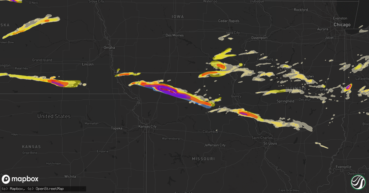
Hail Map on May 6, 2023
Get this storm
May 6 map
$229
one time, instant access
Download today. No call, no setup
Keep the $229
Bought the map and want the full workflow? Apply the entire $229 to a subscription within 7 days. None of it is wasted.
Every map, not just this one
This buys you this map. Subscription and you get every map we run, in the markets you choose from a few cities to whole states to nationwide. Plus real-time alerts the moment a storm fires.
Contact data
Name, contact info, occupancy, even credit band for addresses in the footprint. You go from where it hit to who to call.
Become the source they trust
Unlimited branding weather history reports on demand. You already have the documented answer ready for the property owner, and you are the one who showed up with it.
Property data and RoofTrace estimates
Pull up any address you have got, its value and the exact code rules for that jurisdiction, straight from One Click Code. Then RoofTrace estimates the squares, pitch, and roof value, priced the way you price.
States Impacted by Hail Map on May 6, 2023
Storm reports
Texas
| Date | Description |
|---|---|
| 05/06/20236:44 PM CDT | Report from mping: quarter |
| 05/06/20236:44 PM CDT | A local report indicates 1.00 inch wind near 11 NNW BROWNWOOD |
| 05/06/20236:38 PM CDT | Social media video of power flashes alongside the road. |
| 05/06/20236:35 PM CDT | Report from mping: golf ball |
| 05/06/20236:22 PM CDT | Spotter network report. Time estimated by radar. |
| 05/06/20236:20 PM CDT | A local report indicates 1.50 inch wind near ALBANY |
| 05/06/20236:05 PM CDT | Hail duration lasted for 30 minutes. |
| 05/06/20236:03 PM CDT | Report from mping: quarter |
| 05/06/20235:55 PM CDT | A local report indicates 1.00 inch wind near RULE |
| 05/06/20235:53 PM CDT | Quarter size hail at hords creek lake near coleman. |
| 05/06/20235:48 PM CDT | Law enforcement reports trees and signs blown down in benjamin. Time estimated by radar. |
| 05/06/20235:45 PM CDT | Found off of hwy 283. |
| 05/06/20235:45 PM CDT | A local report indicates 1.75 inch wind near 2 WSW BENOIT |
| 05/06/20235:45 PM CDT | Law enforcement report of hail to just smaller than golf-ball-sized. |
| 05/06/20235:43 PM CDT | A local report indicates 1.25 inch wind near 4 SE ECHO |
| 05/06/20235:42 PM CDT | A local report indicates 1.00 inch wind near 4 SE GLEN COVE |
| 05/06/20235:30 PM CDT | Mostly smaller hail but up to golf ball size was found. |
| 05/06/20235:29 PM CDT | A local report indicates 1.00 inch wind near 3 NW LONGWORTH |
| 05/06/20235:25 PM CDT | A local report indicates 1.75 inch wind near 2 N STAMFORD |
| 05/06/20235:24 PM CDT | A local report indicates 1.75 inch wind near 3 NW THRIFTY |
| 05/06/20235:23 PM CDT | A local report indicates 1.50 inch wind near 1 E BALLINGER |
| 05/06/20235:15 PM CDT | Half dollar to ping pong ball sized hail falling. |
| 05/06/20235:03 PM CDT | A local report indicates 1.75 inch wind near 3 NW SILVER VALLEY |
| 05/06/20235:02 PM CDT | Hail up to quarter size beginning to fall in downtown area. |
| 05/06/20234:37 PM CDT | Report from mping: half dollar |
| 05/06/202312:23 AM CDT | Report from mping: 3-inch tree limbs broken; power poles broken. |
| 05/05/202311:46 PM CDT | Report from mping: 3-inch tree limbs broken; power poles broken. |
| 05/05/202311:05 PM CDT | Social media report of trees snapped in mans best friend dog park in mansfield... Time estimated by radar. |
| 05/05/202310:38 PM CDT | A local report indicates 60 MPH wind near RIO VISTA |
| 05/05/202310:24 PM CDT | Report from mping: 1-inch tree limbs broken; shingles blown off. |
| 05/05/202310:15 PM CDT | A local report indicates 65 MPH wind near GODLEY |
| 05/05/202310:10 PM CDT | A local report indicates 65 MPH wind near 2 N WALNUT SPRINGS |
| 05/05/20239:55 PM CDT | Kgdj awos. |
| 05/05/20239:39 PM CDT | Report from mping: quarter |
| 05/05/20239:30 PM CDT | Off of fm 1176 south of brownwood. |
| 05/05/20239:15 PM CDT | Report from mping: baseball+ |
| 05/05/20238:56 PM CDT | Report from mping: tea cup |
| 05/05/20238:37 PM CDT | Time estimated from radar. |
| 05/05/20238:33 PM CDT | A local report indicates 68 MPH wind near 7 S BOWIE |
| 05/05/20238:20 PM CDT | Mostly quarters off of cr 155 south of bangs. |
| 05/05/20238:12 PM CDT | A local report indicates 2.00 inch wind near BLANKET |
| 05/05/20238:10 PM CDT | Report from mping: tennis ball |
| 05/05/20238:08 PM CDT | A local report indicates 74 MPH wind near 6 N BLANKET |
| 05/05/20238:08 PM CDT | A local report indicates 1.75 inch wind near BLANKET |
| 05/05/20238:08 PM CDT | A local report indicates 74 MPH wind near 6 N BROWNWOOD |
| 05/05/20238:07 PM CDT | Social media user sent in report on facebook. |
| 05/05/20238:05 PM CDT | A local report indicates 2.50 inch wind near 1 N EARLY |
| 05/05/20238:03 PM CDT | Tree blown over onto a home. Time estimated from radar. |
| 05/05/20238:02 PM CDT | A local report indicates 1.00 inch wind near BROWNWOOD |
| 05/05/20238:02 PM CDT | Report from mping: baseball |
| 05/05/20238:00 PM CDT | Corrects previous tstm wnd dmg report from jacksboro. 3 inch oak branches broken at fm2190 and jt graves lane northwest of jacksboro. |
| 05/05/20237:55 PM CDT | Kbwd awos reported 65 kt gust with thunderstorm. |
| 05/05/20237:51 PM CDT | 2-2.5 inch hail estimated to be falling near flat rock campground. |
| 05/05/20237:45 PM CDT | Up to golf ball sized hail. |
| 05/05/20237:44 PM CDT | Report from mping: quarter |
| 05/05/20237:22 PM CDT | Dime to golf ball sized hail falling. |
| 05/05/20237:21 PM CDT | Transformer damage reported in windthorst. |
| 05/05/20237:07 PM CDT | A local report indicates 59 MPH wind near 1 NE SHEPPARD AFB |
| 05/05/20237:01 PM CDT | Report from mping: half dollar |
| 05/05/20237:00 PM CDT | A local report indicates 70 MPH wind near THROCKMORTON |
South Dakota
| Date | Description |
|---|---|
| 05/06/20235:25 PM CDT | Specific location estimated by radar with known dissipation of tornado at 5:30 pm. At least second in a series of brief touchdowns. |
| 05/06/20235:01 PM CDT | Brief touchdown. |
| 05/06/20234:57 PM CDT | Time estimated from radar |
| 05/06/20232:10 PM CDT | Landspout tornado lasted about 3 minutes. No damage reported. |
| 05/05/20237:00 PM CDT | A local report indicates 1.00 inch wind near 3 N HAMILL |
Illinois
| Date | Description |
|---|---|
| 05/06/202312:07 PM CDT | A local report indicates 1.00 inch wind near KAMPSVILLE |
| 05/06/20235:57 AM CDT | Social media photo shows a downed tree and two large branches. Time estimated from radar. |
| 05/06/20235:10 AM CDT | A local report indicates 66 MPH wind near COLES COUNTY AIRPORT |
| 05/06/20233:48 AM CDT | Report from mping: quarter |
| 05/06/20233:48 AM CDT | Re |
| 05/06/20232:20 AM CDT | Large tree blown down. Time estimated from radar. |
| 05/06/20232:13 AM CDT | A local report indicates 1.00 inch wind near PEORIA HEIGHTS |
| 05/06/202312:29 AM CDT | A local report indicates 60 MPH wind near 3 NE PANOLA |
| 05/06/202312:18 AM CDT | Large tree limbs down. Time estimated from radar. |
| 05/06/202312:00 AM CDT | Powerlines down on railroad tracks. Time estimated from radar. |
Louisiana
| Date | Description |
|---|---|
| 05/06/20239:23 AM CDT | Uprooted trees and large branches down on ogise richardson rd. |
| 05/06/20239:00 AM CDT | Half a tree down across the road near miro and esplanade. Estimated the downed half is at least 1ft diameter from picture. Relayed via social media. |
| 05/06/20238:59 AM CDT | Trees and power lines down near penns chapel rd. |
| 05/06/20238:59 AM CDT | Off duty employee estimated 60 mph winds off of hwy 1077. |
| 05/06/20238:57 AM CDT | Multiple trees down and one power pole snapped on scotch pine st. Relayed via social media. |
| 05/06/20238:52 AM CDT | Jefferson parish so reports tree down on hollywood dr in metairie. |
| 05/06/20238:50 AM CDT | Damage to roof and shed on camille dr. |
| 05/06/20238:38 AM CDT | Tree down in luling on barton dr. |
| 05/06/20238:35 AM CDT | Trees down on crapanzano rd and randall rd in hammond. |
| 05/06/20238:32 AM CDT | Em reports tree down on old spanish trail in paradis. |
| 05/06/20238:30 AM CDT | Trees down on ccc rd in montz. Relayed via social media. |
| 05/06/20238:27 AM CDT | Em reports tree down and shed blown into street on kilona dr. |
| 05/06/20238:12 AM CDT | Trees down and damage to one camp from falling limbs in the town of maurepas. |
| 05/06/20237:59 AM CDT | Walker pd reported tree down on mayer st in walker. Parish so also confirmed additional trees also reported down throughout parish... But no details on locations. |
| 05/06/20237:56 AM CDT | Ascension so reports trees down in sorrento. |
| 05/06/20237:54 AM CDT | Ascension so reports trees down in st. Amant. |
| 05/06/20237:49 AM CDT | Ascension so reports trees down in gonzales. |
| 05/06/20237:47 AM CDT | Ascension so reports trees down in prairieville. |
| 05/06/20237:44 AM CDT | *** 1 inj *** central fd reports multiple trees down in town. One tree fell on a trailer on gemini dr causing minor injuries to the occupant. |
Minnesota
| Date | Description |
|---|---|
| 05/06/20236:34 PM CDT | Breif touchdown in an open field. |
| 05/06/20236:23 PM CDT | Law enforcement reported brief touchdown of tornado 6 miles north of renville... Mn. |
| 05/06/20236:22 PM CDT | Trained spotter measured quarter sized hail in sw prinsburg... Mn. |
| 05/06/20235:51 PM CDT | A local report indicates 1.00 inch wind near 3 NW WABASHA |
| 05/06/20235:42 PM CDT | Photo of possible tornado damage to farm shed east of granite falls... Mn. Time estimated via radar. |
| 05/06/20235:42 PM CDT | Video confirms the damage to the outbuilding was caused by a tornado. |
| 05/06/20235:36 PM CDT | A local report indicates 1.25 inch wind near 6 SSW LAKE CITY |
| 05/06/20235:30 PM CDT | Estimated hail size of one inch south of frontenac... Mn. Time estimated via radar. |
Indiana
| Date | Description |
|---|---|
| 05/06/202312:53 AM CDT | Hail up to quarter size falling at a rapid rate. |
| 05/06/202312:37 AM CDT | Report from mping: quarter |
| 05/06/202312:35 AM CDT | Late report of facebook photo showing mainly 1.00 hail with one 1.6 inch hailstone. |
| 05/05/202311:25 PM CDT | A local report indicates 1.00 inch wind near 3 WSW THORNTOWN |
| 05/05/202311:24 PM CDT | A local report indicates 1.00 inch wind near WOLCOTT |
| 05/05/202311:10 PM CDT | A local report indicates 1.25 inch wind near 1 SSW DARLINGTON |
| 05/05/202310:55 PM CDT | Report via twitter. Time estimated via radar. |
| 05/05/202310:40 PM CDT | Public reports via social media of 2-3 inch diameter hail. |
| 05/05/202310:35 PM CDT | Received via social media. |
| 05/05/202310:35 PM CDT | Relayed by broadcast media. |
Nebraska
| Date | Description |
|---|---|
| 05/06/20236:28 PM CDT | Few quarter size hailstones but mostly dime size. |
| 05/06/20236:25 PM CDT | Public reports three inch hail... Golf ball hail... And quarter sized with accumulation of at least 2 inches in depth of hail. |
| 05/06/20236:00 PM CDT | Quarter sized hail near bassett via social media. |
| 05/06/20235:49 PM CDT | Golf ball to ping pong ball sized hail reported. |
| 05/06/20235:34 PM CDT | Public reports landspout touchdown near stockbille. |
| 05/06/20235:30 PM CDT | Ainsworth fire personnel reported pea to quarter sized hail near the sw corner of ainsworth. |
| 05/06/20234:50 PM CDT | Public reports brief land spout near hayes center. |
| 05/06/20236:10 AM CDT | Delayed public report of ping pong ball sized hail. |
| 05/06/20234:15 AM CDT | Time and hail size estimated. |
| 05/06/20234:14 AM CDT | Nickel to quarter sized hail. Report received via social media. |
| 05/06/20234:02 AM CDT | Photo via facebook from 8n ord of hail up to the size of half dollars. Time est. From radar. |
| 05/06/20233:50 AM CDT | Hail up to ping pong ball size was reported... Largest hail occurred around 350am. |
| 05/06/20233:45 AM CDT | Hail up to quarter size was reported... Ground was still partially white after sunrise. Time est. From radar. |
| 05/06/20233:30 AM CDT | Time and hail size estimated. |
| 05/06/20233:25 AM CDT | Enough hail fell to cover the ground. Corrected for time. |
| 05/06/20233:15 AM CDT | Enough hail fell to cover the ground. |
| 05/05/20239:48 PM CDT | Relayed via emergency management. |
| 05/05/20239:48 PM CDT | Report from mping: quarter |
| 05/05/20238:59 PM CDT | A local report indicates 1.75 inch wind near CARLETON |
| 05/05/20238:57 PM CDT | Trained spotter reported hail ranging in size from quarters to golfballs. The large hail lasted about three minutes. |
| 05/05/20238:57 PM CDT | Photos via facebook of golf ball size hail. Lasted 6-10 minutes. |
| 05/05/20238:55 PM CDT | Delayed report via twitter. Time estimated from radar. |
| 05/05/20238:53 PM CDT | Photo via facebook of about tennis ball size hail along hwy 4 west of davenport. Time estimated from radar. |
| 05/05/20238:45 PM CDT | Photo via facebook of about tennis ball size hail south of edgar. Time estimated from radar. |
| 05/05/20238:35 PM CDT | A local report indicates 1.75 inch wind near EDGAR |
| 05/05/20238:34 PM CDT | Photo via twitter of hailstone about two and a half quarters in diameter. Time estimated from radar and nearby reports. |
| 05/05/20238:31 PM CDT | Picture of several golf ball size hailstones via facebook. Time estimated from radar. |
| 05/05/20238:25 PM CDT | Emergency manager reported half dollar sized hail. |
| 05/05/20238:13 PM CDT | Photo via facebook. |
| 05/05/20237:50 PM CDT | Public reports nickel and quarter sized hail around. |
| 05/05/20237:14 PM CDT | Public estimates 60 mph winds. |
| 05/05/20237:13 PM CDT | A local report indicates 1.00 inch wind near 4 S MINDEN |
| 05/05/20237:00 PM CDT | Public reports quarter sized hail near mm 161 and mm 162 on highway 83 n. |
| 05/05/20237:00 PM CDT | Social media report of hail ranging in size from peas to quarters. |
Iowa
| Date | Description |
|---|---|
| 05/06/20231:23 AM CDT | Delayed report... Picture on social media. |
| 05/05/202311:20 PM CDT | A local report indicates 1.00 inch wind near RIVERSIDE |
| 05/05/202310:42 PM CDT | Delayed report. |
| 05/05/202310:41 PM CDT | Delayed report. |
| 05/05/202310:34 PM CDT | A local report indicates 1.00 inch wind near 3 ESE BATAVIA |
| 05/05/20239:49 PM CDT | A local report indicates 1.00 inch wind near 1 W WEST BURLINGTON |
| 05/05/20239:45 PM CDT | Trees down and shingles off roof. |
| 05/05/20239:38 PM CDT | 8 inch diameter limbs down. Time estimated. |
| 05/05/20238:52 PM CDT | Golf ball size hail now falling as storm seems to be growing in strength. |
| 05/05/20238:25 PM CDT | A few half dollar sized hail stones now falling at the time of this report. |
| 05/05/20238:17 PM CDT | Quarter sized hail now falling with very strong wind gusts causing minor tree damage. |
Oklahoma
| Date | Description |
|---|---|
| 05/06/202312:28 AM CDT | A local report indicates 60 MPH wind near 1 E WARNER |
| 05/06/202312:15 AM CDT | A local report indicates 69 MPH wind near 3 WNW STIGLER |
| 05/05/202311:29 PM CDT | A local report indicates 63 MPH wind near MCALESTER REGIONAL AIRP |
| 05/05/202311:20 PM CDT | Barn roof catapulted blown into tree. |
| 05/05/20238:23 PM CDT | A local report indicates 1.00 inch wind near 4 W LAWTON |
| 05/05/20238:10 PM CDT | A television storm chaser measured winds of 81 mph just south of lawton. The specific location is estimated. |
| 05/05/20237:38 PM CDT | Social media report. |
| 05/05/20237:30 PM CDT | A local report indicates 1.50 inch wind near 2 N HOLLISTER |
| 05/05/20237:19 PM CDT | A local report indicates 1.75 inch wind near 2 SSW FREDERICK |
Missouri
| Date | Description |
|---|---|
| 05/06/20236:52 PM CDT | Mostly quarters with golf ball to baseball size hail stones mixed in. Winds gusting over 60 mph as well. Visible wall cloud. |
| 05/06/20236:50 PM CDT | Estimated from picture submitted on social media. |
| 05/06/20236:19 PM CDT | Golf ball sized hail reported. |
| 05/06/20235:55 PM CDT | Reported via social media. |
| 05/06/20235:15 PM CDT | Delayed report... Another round of hail south of maryville. |
| 05/06/20235:10 PM CDT | Intermittent rounds of golf ball size hail. Reported via social media. |
| 05/06/20234:55 PM CDT | 1-inch hail was reported. |
| 05/06/20234:47 PM CDT | Report from mping: golf ball |
| 05/06/20234:44 PM CDT | A local report indicates 1.75 inch wind near WESTBORO |
| 05/06/20234:38 PM CDT | Report from mping: quarter |
| 05/06/20234:20 PM CDT | Reported via social media. |
| 05/06/20234:16 PM CDT | Delayed report received on facebook. Largest hail observed was golf ball size. Time estimated from radar. |
| 05/06/202310:50 AM CDT | Via twitter. Nickel to quarter size hail. |
| 05/06/202310:50 AM CDT | Via facebook with picture. |
| 05/06/202312:47 AM CDT | Delayed report... Pea to half dollar size hail in 3 rounds of storms. |
| 05/06/202312:10 AM CDT | Up to golf ball-sized hail at intersection of hwy 136 and county road aa. |
| 05/05/202311:16 PM CDT | Report from twitter of quarter size hail. |
| 05/05/202310:08 PM CDT | Report from mping: golf ball |
| 05/05/202310:07 PM CDT | Reported via social media. |
| 05/05/202310:05 PM CDT | Report from mping: half dollar |
| 05/05/202310:01 PM CDT | Measured 2 diameter hail. |
| 05/05/20239:25 PM CDT | A local report indicates 1.00 inch wind near ETHEL |
| 05/05/20239:25 PM CDT | Reported wind gust of 80 to 90 mph. |
| 05/05/20239:24 PM CDT | Church with roof damage in downtown trenton. |
| 05/05/20239:03 PM CDT | Quarter sized hail currently falling. |
| 05/05/20238:43 PM CDT | Multiple reports of damage in the vicinity... Machine shed damaged. |
| 05/05/20238:29 PM CDT | Likely rear-flank downdraft winds... Hog barn roof blown off. |
| 05/05/20237:57 PM CDT | This updates a previous hail report. Quarter to baseball size hail. 16 gauge steel siding damaged/dented. Some cattle injured. |
| 05/05/20237:57 PM CDT | Quarter and baseball sized hail falling. |
| 05/05/20237:57 PM CDT | Report from mping: tennis ball |
| 05/05/20237:53 PM CDT | A local report indicates 2.75 inch wind near 2 E TRENTON |
| 05/05/20237:50 PM CDT | A local report indicates 1.75 inch wind near TRENTON |
| 05/05/20237:45 PM CDT | Building damaged and house collapsed...debris covering highway 6 and sw 52nd st. |
| 05/05/20237:42 PM CDT | Delayed report. Photos of measured 4 inch diameter hail. |
| 05/05/20237:42 PM CDT | Corrects previous tornado report from trenton. Church with roof damage in downtown trenton. Time estimated from radar. |
| 05/05/20237:26 PM CDT | A local report indicates 4.00 inch wind near 2 S COFFEY |
| 05/05/20237:24 PM CDT | Hail penetrated the roof of a steel structure. |
| 05/05/20237:20 PM CDT | Reported via fire dept and 911 dispatch. |
| 05/05/20237:15 PM CDT | Wind gusts 60-70 mph winds reported. |
| 05/05/20237:14 PM CDT | Reported via social media. |
| 05/05/20237:11 PM CDT | Reported via social/broadcast media. |
Cities Impacted by Hail Map on May 6, 2023
- Gonzales, LA
- Denham Springs, LA
- Saint Amant, LA
- Sorrento, LA
- Darrow, LA
- Prairieville, LA
- Baton Rouge, LA
- Geismar, LA
- French Settlement, LA
- Saint Gabriel, LA
- Livingston, LA
- Maurepas, LA
- Springfield, LA
- Gramercy, LA
- Garyville, LA
- Ponchatoula, LA
- La Place, LA
- Holden, LA
- Hammond, LA
- Madisonville, LA
- Donaldsonville, LA
- Paulina, LA
- Convent, LA
- Vacherie, LA
- Mount Airy, LA
- Saint James, LA
- Lutcher, LA
- Edgard, LA
- Hahnville, LA
- Reserve, LA
- Mandeville, LA
- Saint Rose, LA
- Luling, LA
- Metairie, LA
- Destrehan, LA
- Kenner, LA
- Ama, LA
- Covington, LA
- Abita Springs, LA
- Norco, LA
- New Orleans, LA
- Boutte, LA
- Lacombe, LA
- Westwego, LA
- Marrero, LA
- Harvey, LA
- Gretna, LA
- Chalmette, LA
- Arabi, LA
- Belle Chasse, LA
- Meraux, LA
- Slidell, LA
- Pearl River, LA
- White Castle, LA
- Carville, LA
- Picayune, MS
- Robert, LA
- Belle Rose, LA
- Paradis, LA
- Violet, LA
- Des Allemands, LA
- Braithwaite, LA
- Saint Bernard, LA
- Thibodaux, LA
- Gulfport, MS
- Stennis Space Center, MS
- Pass Christian, MS
- Kiln, MS
- Diamondhead, MS
- Waveland, MS
- Bay Saint Louis, MS
- Pearlington, MS
- Long Beach, MS
- Raceland, LA
- Lafitte, LA
- Cut Off, LA
- Port Sulphur, LA
- Lockport, LA
- Barataria, LA
- Frankford, MO
- Louisiana, MO
- Bowling Green, MO
- Pleasant Hill, IL
- Rockport, IL
- Clarksville, MO
- Nebo, IL
- Kampsville, IL
- Pearl, IL
- White Hall, IL
- Eldred, IL
- Carrollton, IL
- Franklin, LA
- Ethel, MO
- Bucklin, MO
- Ridgeway, MO
- Princeton, MO
- Theriot, LA
- Evergreen, LA
- Plaucheville, LA
- Morrow, LA
- Ville Platte, LA
- Washington, LA
- Moberly, MO
- Madison, MO
- Holliday, MO
- Stoutsville, MO
- Paris, MO
- Brookfield, MO
- Folsom, LA
- Green Castle, MO
- New London, MO
- Shelbina, MO
- Loreauville, LA
- Jeanerette, LA
- New Iberia, LA
- Cairo, MO
- Macon, MO
- Oakdale, LA
- Rutledge, MO
- Memphis, MO
- Callao, MO
- Atlanta, MO
- New Cambria, MO
- New Boston, MO
- Elmer, MO
- La Plata, MO
- Gibbs, MO
- Monroe City, MO
- Kirksville, MO
- Perry, MO
- Baldwin, LA
- Ashburn, MO
- Center, MO
- Curryville, MO
- New Canton, IL
- Kinderhook, IL
- Novinger, MO
- Auxvasse, MO
- Columbia, MO
- Bunkie, LA
- Hamburg, IA
- Farragut, IA
- Riverton, IA
- Peru, NE
- Watson, MO
- Rock Port, MO
- Tarkio, MO
- Westboro, MO
- Hamlin, TX
- Stamford, TX
- Valera, TX
- Talpa, TX
- Coleman, TX
- Skidmore, MO
- Maryville, MO
- Throckmorton, TX
- Aspermont, TX
- Old Glory, TX
- Rule, TX
- Novice, TX
- Bangs, TX
- Santa Anna, TX
- Brownwood, TX
- Elmo, MO
- Clyde, TX
- Miles, TX
- Ballinger, TX
- Norton, TX
- Seymour, TX
- Rochester, TX
- O'Brien, TX
- Rotan, TX
- Sweetwater, TX
- Roby, TX
- Barnard, MO
- Conception Junction, MO
- Burlington Junction, MO
- Clearmont, MO
- Blanchard, IA
- Hopkins, MO
- Burkett, TX
- Haskell, TX
- Clyde, MO
- Conception, MO
- Stanberry, MO
- Benjamin, TX
- Baird, TX
- Cross Plains, TX
- Johnstown, NE
- Ainsworth, NE
- Long Pine, NE
- Bassett, NE
- Albany, MO
- Guilford, MO
- Cody, NE
- Wanblee, SD
- Simmesport, LA
- Kyle, SD
- Howes, SD
- Morgan City, LA
- Wounded Knee, SD
- Batesland, SD
- Martin, SD
- Allen, SD
- Porcupine, SD
- Dulac, LA
- Chauvin, LA
- Montegut, LA
- Midland, SD
- Raymond, IL
- Carlinville, IL
- Nilwood, IL
- Waggoner, IL
- Girard, IL
- Morganza, LA
- New Roads, LA
- Waseca, MN
- New Richland, MN
- Enning, SD
- White Owl, SD
- Gibson, LA
- Melville, LA
- Lettsworth, LA
- Palmetto, LA
- Batchelor, LA
- Rushville, NE
- Lakeland, LA
- Oscar, LA
- Erwinville, LA
- Jarreau, LA
- Palisade, NE
- Wauneta, NE
- Hayes Center, NE
- Bingham, IL
- Fillmore, IL
- Ravenwood, MO
- Maitland, MO
- Mound City, MO
- Valentine, NE
- Cisne, IL
- Mount Erie, IL
- Harvel, IL
- Milesville, SD
- Belle Fourche, SD
- Cherry Creek, SD
- Goodhue, MN
- Litchfield, IL
- Golden Meadow, LA
- Grand Isle, LA
- Livonia, LA
- Ventress, LA
- Newell, SD
- Port Allen, LA
- Hillsboro, IL
- Irving, IL
- Flora, IL
- Shipman, IL
- Gillespie, IL
- Schriever, LA
- Ramsey, IL
- Hulett, WY
- Bunker Hill, IL
- Medora, IL
- Mount Olive, IL
- Chesterfield, IL
- Benld, IL
- Altamont, IL
- Cowden, IL
- Saint Elmo, IL
- Beecher City, IL
- Rinard, IL
- Clay City, IL
- Coffeen, IL
- Witt, IL
- New Underwood, SD
- Rockbridge, IL
- Butler, IL
- Kane, IL
- Taylor Springs, IL
- Sawyerville, IL
- Fieldon, IL
- West Salem, IL
- Nokomis, IL
- Oconee, IL
- Staunton, IL
- Walshville, IL
- Mulberry Grove, IL
- Vandalia, IL
- Mason, IL
- Brownstown, IL
- Albany, TX
- Sylvester, TX
- Newport, NE
- Darlington, MO
- McCaulley, TX
- Sacred Heart, MN
- Clara City, MN
- Raymond, MN
- Renville, MN
- Prinsburg, MN
- Willmar, MN
- Stuart, NE
- Bethany, MO
- McFall, MO
- New Hampton, MO
- Pattonsburg, MO
- Coffey, MO
- Thedford, NE
- Seneca, NE
- May, TX
- Davidson, OK
- Elsmere, NE
- Rising Star, TX
- Gilman City, MO
- Frederick, OK
- Jameson, MO
- Jamesport, MO
- Hollister, OK
- Gallatin, MO
- Trenton, MO
- King City, MO
- Loveland, OK
- Abilene, TX
- Laredo, MO
- Indiahoma, OK
- Chattanooga, OK
- Cache, OK
- Faxon, OK
- Snyder, OK
- Early, TX
- Blanket, TX
- Lawton, OK
- Chillicothe, MO
- Chula, MO
- Linneus, MO
- Wheeling, MO
- Browning, MO
- Humphreys, MO
- Purdin, MO
- Galt, MO
- Meadville, MO
- Laclede, MO
- Blue Hill, NE
- Glenvil, NE
- Lawrence, NE
- Fairfield, NE
- Cisco, TX
- Deweese, NE
- Edgar, NE
- Ong, NE
- Nelson, NE
- Oak, NE
- Davenport, NE
- Brookesmith, TX
- Winigan, MO
- Bruning, NE
- Shickley, NE
- Carleton, NE
- Stephenville, TX
- Bluff Dale, TX
- Tolar, TX
- Lipan, TX
- Santo, TX
- Granbury, TX
- Weatherford, TX
- Belvidere, NE
- Deshler, NE
- Hebron, NE
- Daykin, NE
- Ohiowa, NE
- Western, NE
- Alexandria, NE
- Tobias, NE
- Gilead, NE
- Fairbury, NE
- Plymouth, NE
- Jansen, NE
- De Witt, NE
- Hico, TX
- Walnut Springs, TX
- Marceline, MO
- Excello, MO
- Jacksonville, MO
- Bevier, MO
- Mount Sterling, IA
- Bonaparte, IA
- Keosauqua, IA
- West Burlington, IA
- Danville, IA
- Middletown, IA
- Burlington, IA
- Wever, IA
- Arbela, MO
- Luray, MO
- Kahoka, MO
- Glen Rose, TX
- Rainbow, TX
- Douds, IA
- Birmingham, IA
- Milton, IA
- Cantril, IA
- Stockport, IA
- Selma, IA
- Eldon, IA
- Floris, IA
- Bloomfield, IA
- Anabel, MO
- Clarence, MO
- Godley, TX
- Cleburne, TX
- Joshua, TX
- Nemo, TX
- Lentner, MO
- Batavia, IA
- Libertyville, IA
- Fairfield, IA
- Rio Vista, TX
- Blum, TX
- Covington, TX
- Grandview, TX
- Itasca, TX
- Attica, IN
- Williamsport, IN
- Perrysville, IN
- Covington, IN
- Alvarado, TX
- Burleson, TX
- Mansfield, TX
- Lillian, TX
- Venus, TX
- Midlothian, TX
- Milford, TX
- Italy, TX
- Waxahachie, TX
- Maypearl, TX
- Forreston, TX
- Waurika, OK
- Ryan, OK
- Petrolia, TX
- Byers, TX
- Breckenridge, TX
- Wabasha, MN
- Ideal, SD
- Drakesville, IA
- Moran, TX
- Henrietta, TX
- Bellevue, TX
- Bowie, TX
- Sturgis, SD
- Ozona, TX
- Wood Lake, NE
- Springview, NE
- Independence, WI
- Whitehall, WI
- Hanley Falls, MN
- Granite Falls, MN
- Woodson, TX
- Atkinson, NE
- Vale, SD
- Zumbrota, MN
- Wanamingo, MN
- Munday, TX
- Knox City, TX
- Crowell, TX
- Nocona, TX
- Ringgold, TX
- Blomkest, MN
- Mazeppa, MN
- Lake City, MN
- Vernon, TX
- Beatrice, NE
- Hennepin, OK
- Holliday, TX
- Baker, LA
- Naper, NE
- Avoca, TX
- Wichita Falls, TX
- Olney, TX
- Wood, SD
- Winner, SD
- Winnett, MT
- Farnam, NE
- Eustis, NE
- Bertrand, NE
- Smithfield, NE
- Curtis, NE
- Elwood, NE
- Stockville, NE
- Moorefield, NE
- Alma, WI
- Holstein, NE
- Loomis, NE
- Holdrege, NE
- Clay Center, NE
- Roseland, NE
- Bladen, NE
- Minden, NE
- Campbell, NE
- Wilcox, NE
- Funk, NE
- Ayr, NE
- Axtell, NE
- Hildreth, NE
- Sutton, NE
- Elgin, OK
- Dublin, TX
- Martinsville, MO
- Newcastle, TX
- Comanche, TX
- De Leon, TX
- Goree, TX
- Jacksboro, TX
- Mills, NE
- Archer City, TX
- Windthorst, TX
- Red Wing, MN
- Hawley, TX
- Anson, TX
- Gregory, SD
- Hamill, SD
- Oklaunion, TX
- Arapahoe, NE
- Geneva, NE
- Ogallala, NE
- Wasta, SD
- Arcadia, WI
- Gentry, MO
- Loving, TX
- Millville, MN
- Scotland, TX
- Lake Lillian, MN
- Merkel, TX
- Nelson, WI
- Maywood, NE
- Ringling, OK
- Loco, OK
- Harrold, TX
- Milan, MO
- Graham, MO
- Mondovi, WI
- Lueders, TX
- Glynn, LA
- Kenyon, MN
- Sidney, TX
- Shelbyville, MO
- Lockridge, IA
- Bethel, MO
- Ennis, TX
- Palmer, TX
- Ferris, TX
- Red Oak, TX
- Cedar Hill, TX
- Remington, IN
- Wolcott, IN
- Fowler, IN
- Reynolds, IN
- Kemp, TX
- Scurry, TX
- Rosser, TX
- Pittsburg, OK
- Stuart, OK
- Kiowa, OK
- Mcalester, OK
- Blanco, OK
- Savanna, OK
- Krebs, OK
- Tuskahoma, OK
- Haileyville, OK
- Hartshorne, OK
- Wilburton, OK
- Red Oak, OK
- Quinton, OK
- Eufaula, OK
- Talihina, OK
- Wister, OK
- Kinta, OK
- Brighton, IA
- Wayland, IA
- Washington, IA
- Chandlerville, IL
- Oakford, IL
- Petersburg, IL
- Shady Point, OK
- Bokoshe, OK
- Mccurtain, OK
- Keota, OK
- Stigler, OK
- Porum, OK
- Whitefield, OK
- Mount Pleasant, IA
- Crawfordsville, IA
- Glenwood, MO
- Livonia, MO
- Coatsville, MO
- Lancaster, MO
- Downing, MO
- Greenview, IL
- Athens, IL
- Veedersburg, IN
- Lebanon, IN
- Whitestown, IN
- Mount Union, IA
- Pulaski, IA
- Spiro, OK
- Corsicana, TX
- Atlanta, IN
- Elwood, IN
- Tipton, IN
- Farmington, IA
- Peoria, IL
- Edwards, IL
- Peoria Heights, IL
- Wall, SD
- Le Roy, IL
- Sargent, NE
- Comstock, NE
- Burwell, NE
- Elyria, NE
- Bartlett, NE
- Caroline, WI
- Paris, TX
- Powderly, TX
- Roxton, TX
- Brookston, TX
- Roachdale, IN
- Bainbridge, IN
- Russellville, IN
- Greencastle, IN
- Caddo, TX
- Pekin, IL
- Groveland, IL
- Indianapolis, IN
- Brownsburg, IN
- Rensselaer, IN
- Francesville, IN
- Tolono, IL
- Darlington, IN
- Ingomar, MT
- Musselshell, MT
- Zionsville, IN
- Pittsboro, IN
- Broken Bow, OK
- Purdon, TX
- Barry, TX
- Coalgate, OK
- Wardville, OK
- Atoka, OK
- Roseville, IL
- Galesburg, IL
- Berwick, IL
- Abingdon, IL
- Cameron, IL
- Monmouth, IL
- Gilson, IL
- Maquon, IL
- Lomax, IL
- Dallas City, IL
- La Harpe, IL
- Mount Pulaski, IL
- Latham, IL
- Warrensburg, IL
- Middletown, IL
- New Holland, IL
- Lincoln, IL
- Beason, IL
- Maroa, IL
- Elkhart, IL
- Chestnut, IL
- Clinton, IL
- Kenney, IL
- Metamora, IL
- Roanoke, IL
- Benson, IL
- South English, IA
- Mediapolis, IA
- Morning Sun, IA
- Wapello, IA
- Keithsburg, IL
- Oakville, IA
- Rattan, OK
- Warsaw, IL
- Basco, IL
- Danville, IL
- Sadorus, IL
- Monticello, IL
- Ivesdale, IL
- Bement, IL
- Fithian, IL
- Hillsboro, IA
- Chalmers, IN
- Easton, IL
- Junction City, WI
- Stevens Point, WI
- Detroit, TX
- Bagwell, TX
- Shawano, WI
- Marion, WI
- Minonk, IL
- Monticello, IN
- Idaville, IN
- Star City, IN
- Monon, IN
- Burnettsville, IN
- Cisco, IL
- Argenta, IL
- Riverside, IA
- Wellman, IA
- Kalona, IA
- Parnell, IA
- Mason City, IL
- Lewistown, IL
- Cuba, IL
- Crawfordsville, IN
- Winamac, IN
- Royal Center, IN
- Brookston, IN
- Rushville, IL
- Frederick, IL
- Mount Sterling, IL
- Creve Coeur, IL
- Mosinee, WI
- Custer, WI
- Rosholt, WI
- Canadian, OK
- Elmwood, IL
- Yates City, IL
- Trivoli, IL
- Tallula, IL
- Beardstown, IL
- Ashland, IL
- Virginia, IL
- Queen City, MO
- Hillsboro, TX
- Beverly Shores, IN
- La Porte, IN
- Michigan City, IN
- Blandinsville, IL
- East Peoria, IL
- Washington, IL
- Daisy, OK
- Stringtown, OK
- Milford, IL
- Frost, TX
- Blooming Grove, TX
- Bethel, OK
- Arcadia, IN
- Kingman, IN
- Sumner, TX
- Rochester, IN
- Nashoba, OK
- Hugo, OK
- New Market, IN
- New Ross, IN
- Advance, IN
- Jamestown, IN
- Ladoga, IN
- Carbon, TX
- Snow, OK
- Thorntown, IN
- Newark, MO
- West Point, IA
- Fort Madison, IA
- Ashkum, IL
- Logansport, IN
- Twelve Mile, IN
- Lucerne, IN
- Carthage, IL
- Green Valley, IL
- Manito, IL
- San Jose, IL
- Macomb, IL
- Denmark, IA
- Atwood, OK
- Holdenville, OK
- Dewey, IL
- Liverpool, IL
- Canton, IL
- Donnellson, IA
- Champaign, IL
- Worthington, MO
- Wayland, MO
- Watson, OK
- Ludlow, IL
- Watseka, IL
- Sheldon, IL
- Whitney, TX
- Salem, IA
- Chillicothe, IL
- Dunlap, IL
- Edelstein, IL
- Leonard, MO
- Glasford, IL
- Mapleton, IL
- Dana, IL
- Minier, IL
- Hopedale, IL
- Hanna City, IL
- Ridge Farm, IL
- Keota, IA
- Iowa City, IA
- North English, IA
- Crowley, TX
- Kopperl, TX
- Keene, TX
- Cresson, TX
- Mahomet, IL
- Brimfield, IL
- Forest City, IL
- Chesterton, IN
- Bryant, IL
- Clifton, IL
- Industry, IL
- Plymouth, IL
- Colchester, IL
- Adair, IL
- Table Grove, IL
- Valliant, OK
- Westville, IL
- Rice, TX
- Eastland, TX
- Elgin, NE
- Clearwater, NE
- Oakdale, NE
- Ord, NE
- Ericson, NE
- Broken Bow, NE
- Merna, NE
- Tilden, NE
- Allerton, IL
- Broadlands, IL
- Homer, IL
- Sidell, IL
- Martin, MI
- Shelbyville, MI
- Hopkins, MI
- Tuscola, IL
- Medaryville, IN
- Laura, IL
- Fennville, MI
- Sidney, IL
- Saint Joseph, IL
- Philo, IL
- Urbana, IL
- Ogden, IL
- Casey, IL
- Goodland, IN
- Avon, IN
- Danville, IN
- Metcalf, IL
- Chrisman, IL
- Bloomington, IL
- Bellflower, IL
- Farmer City, IL
- Allegan, MI
- Otsego, MI
- Oldenburg, IN
- Batesville, IN
- Petersburg, NE
- Ewing, NE
- Meadow Grove, NE
- Mertens, TX
- Bynum, TX
- Argyle, IA
- Trenton, OH
- Middletown, OH
- Somerville, OH
- Waynetown, IN
- Kempton, IN
- Clarks Hill, IN
- Waveland, IN
- Alamo, IN
- North Salem, IN
- Sheridan, IN
- New Richmond, IN
- Frankfort, IN
- Linden, IN
- Kirklin, IN
- Turners Station, KY
- Kentland, IN
- Danvers, IL
- Mackinaw, IL
- Centerpoint, IN
- Malone, TX
- Abbott, TX
- Oakwood, IL
- Otterbein, IN
- Oxford, IN
- Smithshire, IL
- North Henderson, IL
- Alexis, IL
- Waynesville, IL
- Wapella, IL
- Rantoul, IL
- Goodfield, IL
- Mansfield, IL
- Heyworth, IL
- Carlock, IL
- Shirley, IL
- Deer Creek, IL
- Arrowsmith, IL
- Downs, IL
- Tremont, IL
- Normal, IL
- Delavan, IL
- Congerville, IL
- Morton, IL
- South Pekin, IL
- Stanford, IL
- Frankton, IN
- Alexandria, IN
- Hamilton, MI
- Earl Park, IN
- Ellisville, IL
- Bushnell, IL
- Smithfield, IL
- Avon, IL
- Marietta, IL
- Martinsville, IL
- Westfield, IL
- Gosport, IN
- Paragon, IN
- Connersville, IN
- Muncie, IN
- Yorktown, IN
- Gaston, IN
- Armington, IL
- McLean, IL
- Paxton, IL
- Cerro Gordo, IL
- Villa Grove, IL
- Decatur, IL
- Milmine, IL
- Atwood, IL
- Hammond, IL
- Arcola, IL
- Oreana, IL
- Pesotum, IL
- Greenup, IL
- Martinsville, IN
- Cloverdale, IN
- Quincy, IN
- Hillsdale, IN
- Dana, IN
- Cayuga, IN
- Bath, IN
- Oxford, OH
- Brookville, IN
- West College Corner, IN
- De Land, IL
- Westfield, IN
- Newman, IL
- Seymour, IL
- Aledo, IL
- Joy, IL
- Seaton, IL
- Fisher, IL
- Foosland, IL
- Camden, OH
- Unionville, MO
- Liberty, IN
- Madison, IN
- Donovan, IL
- Iroquois, IL
- Topeka, IL
- Knightstown, IN
- Carthage, IN
- Canaan, IN
- Neligh, NE
- Sciota, IL
- Niota, IL
- Bismarck, IL
- Alvin, IL
- Wataga, IL
- Eaton, IN
- Good Hope, IL
- Prairie City, IL
- Bardolph, IL
- Saint David, IL
- Strawn, TX
- Braddyville, IA
- Greenfield, IN
- Wilkinson, IN
- Liberty Center, IN
- Warren, IN
- Summitville, IN
- Hidalgo, IL
- Covert, MI
- Watervliet, MI
- Reelsville, IN
- Poland, IN
- Brazil, IN
- Hamilton, OH
- Shelbyville, IN
- Lewisville, IN
- Straughn, IN
- New Castle, IN
- Seymour, IN
- Huntington, IN
- Bennington, IN
- Charleston, IL
- Kempton, IL
- Boswell, IN
- Rio, IL
- Wayland, MI
- Campbellton, TX
- Beeville, TX
- Kenedy, TX
- Jourdanton, TX
- Pleasanton, TX
- Uvalde, TX
- Campbellsburg, KY
- Milton, KY
- Saugatuck, MI
- Dry Ridge, KY
- Crittenden, KY
- Lynchburg, OH
- Hillsboro, OH
- Coloma, MI
- Hartford, MI
- Bangor, MI
- Longview, IL
- Ellsworth, IL
- Warsaw, KY
- Glencoe, KY
- Patriot, IN
- Verona, KY
- Williamstown, KY
- Saint Paul, IA
- Florence, IN
- Rising Sun, IN
- Plainwell, MI
- Gorman, TX
- Crystal City, TX