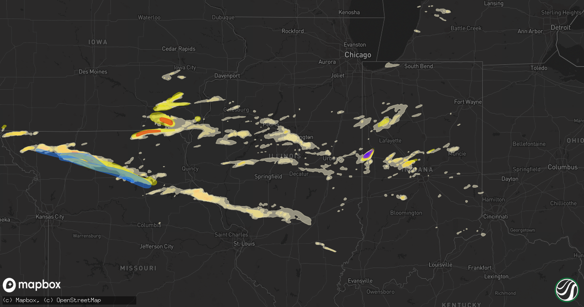
Hail Map in Illinois on May 6, 2023
Get this storm
May 6 map
$229
one time, instant access
Download today. No call, no setup
Keep the $229
Bought the map and want the full workflow? Apply the entire $229 to a subscription within 7 days. None of it is wasted.
Every map, not just this one
This buys you this map. Subscription and you get every map we run, in the markets you choose from a few cities to whole states to nationwide. Plus real-time alerts the moment a storm fires.
Contact data
Name, contact info, occupancy, even credit band for addresses in the footprint. You go from where it hit to who to call.
Become the source they trust
Unlimited branding weather history reports on demand. You already have the documented answer ready for the property owner, and you are the one who showed up with it.
Property data and RoofTrace estimates
Pull up any address you have got, its value and the exact code rules for that jurisdiction, straight from One Click Code. Then RoofTrace estimates the squares, pitch, and roof value, priced the way you price.
Storm reports in Illinois
Illinois
| Date | Description |
|---|---|
| 05/06/202312:07 PM CDT | A local report indicates 1.00 inch wind near KAMPSVILLE |
| 05/06/20235:57 AM CDT | Social media photo shows a downed tree and two large branches. Time estimated from radar. |
| 05/06/20235:10 AM CDT | A local report indicates 66 MPH wind near COLES COUNTY AIRPORT |
| 05/06/20233:48 AM CDT | Report from mping: quarter |
| 05/06/20233:48 AM CDT | Re |
| 05/06/20232:20 AM CDT | Large tree blown down. Time estimated from radar. |
| 05/06/20232:13 AM CDT | A local report indicates 1.00 inch wind near PEORIA HEIGHTS |
| 05/06/202312:29 AM CDT | A local report indicates 60 MPH wind near 3 NE PANOLA |
| 05/06/202312:18 AM CDT | Large tree limbs down. Time estimated from radar. |
| 05/06/202312:00 AM CDT | Powerlines down on railroad tracks. Time estimated from radar. |
All States Impacted by Hail Map on May 6, 2023
Cities Impacted by Hail Map on May 6, 2023
- Gonzales, LA
- Denham Springs, LA
- Saint Amant, LA
- Sorrento, LA
- Darrow, LA
- Prairieville, LA
- Baton Rouge, LA
- Geismar, LA
- French Settlement, LA
- Saint Gabriel, LA
- Livingston, LA
- Maurepas, LA
- Springfield, LA
- Gramercy, LA
- Garyville, LA
- Ponchatoula, LA
- La Place, LA
- Holden, LA
- Hammond, LA
- Madisonville, LA
- Donaldsonville, LA
- Paulina, LA
- Convent, LA
- Vacherie, LA
- Mount Airy, LA
- Saint James, LA
- Lutcher, LA
- Edgard, LA
- Hahnville, LA
- Reserve, LA
- Mandeville, LA
- Saint Rose, LA
- Luling, LA
- Metairie, LA
- Destrehan, LA
- Kenner, LA
- Ama, LA
- Covington, LA
- Abita Springs, LA
- Norco, LA
- New Orleans, LA
- Boutte, LA
- Lacombe, LA
- Westwego, LA
- Marrero, LA
- Harvey, LA
- Gretna, LA
- Chalmette, LA
- Arabi, LA
- Belle Chasse, LA
- Meraux, LA
- Slidell, LA
- Pearl River, LA
- White Castle, LA
- Carville, LA
- Picayune, MS
- Robert, LA
- Belle Rose, LA
- Paradis, LA
- Violet, LA
- Des Allemands, LA
- Braithwaite, LA
- Saint Bernard, LA
- Thibodaux, LA
- Gulfport, MS
- Stennis Space Center, MS
- Pass Christian, MS
- Kiln, MS
- Diamondhead, MS
- Waveland, MS
- Bay Saint Louis, MS
- Pearlington, MS
- Long Beach, MS
- Raceland, LA
- Lafitte, LA
- Cut Off, LA
- Port Sulphur, LA
- Lockport, LA
- Barataria, LA
- Frankford, MO
- Louisiana, MO
- Bowling Green, MO
- Pleasant Hill, IL
- Rockport, IL
- Clarksville, MO
- Nebo, IL
- Kampsville, IL
- Pearl, IL
- White Hall, IL
- Eldred, IL
- Carrollton, IL
- Franklin, LA
- Ethel, MO
- Bucklin, MO
- Ridgeway, MO
- Princeton, MO
- Theriot, LA
- Evergreen, LA
- Plaucheville, LA
- Morrow, LA
- Ville Platte, LA
- Washington, LA
- Moberly, MO
- Madison, MO
- Holliday, MO
- Stoutsville, MO
- Paris, MO
- Brookfield, MO
- Folsom, LA
- Green Castle, MO
- New London, MO
- Shelbina, MO
- Loreauville, LA
- Jeanerette, LA
- New Iberia, LA
- Cairo, MO
- Macon, MO
- Oakdale, LA
- Rutledge, MO
- Memphis, MO
- Callao, MO
- Atlanta, MO
- New Cambria, MO
- New Boston, MO
- Elmer, MO
- La Plata, MO
- Gibbs, MO
- Monroe City, MO
- Kirksville, MO
- Perry, MO
- Baldwin, LA
- Ashburn, MO
- Center, MO
- Curryville, MO
- New Canton, IL
- Kinderhook, IL
- Novinger, MO
- Auxvasse, MO
- Columbia, MO
- Bunkie, LA
- Hamburg, IA
- Farragut, IA
- Riverton, IA
- Peru, NE
- Watson, MO
- Rock Port, MO
- Tarkio, MO
- Westboro, MO
- Hamlin, TX
- Stamford, TX
- Valera, TX
- Talpa, TX
- Coleman, TX
- Skidmore, MO
- Maryville, MO
- Throckmorton, TX
- Aspermont, TX
- Old Glory, TX
- Rule, TX
- Novice, TX
- Bangs, TX
- Santa Anna, TX
- Brownwood, TX
- Elmo, MO
- Clyde, TX
- Miles, TX
- Ballinger, TX
- Norton, TX
- Seymour, TX
- Rochester, TX
- O'Brien, TX
- Rotan, TX
- Sweetwater, TX
- Roby, TX
- Barnard, MO
- Conception Junction, MO
- Burlington Junction, MO
- Clearmont, MO
- Blanchard, IA
- Hopkins, MO
- Burkett, TX
- Haskell, TX
- Clyde, MO
- Conception, MO
- Stanberry, MO
- Benjamin, TX
- Baird, TX
- Cross Plains, TX
- Johnstown, NE
- Ainsworth, NE
- Long Pine, NE
- Bassett, NE
- Albany, MO
- Guilford, MO
- Cody, NE
- Wanblee, SD
- Simmesport, LA
- Kyle, SD
- Howes, SD
- Morgan City, LA
- Wounded Knee, SD
- Batesland, SD
- Martin, SD
- Allen, SD
- Porcupine, SD
- Dulac, LA
- Chauvin, LA
- Montegut, LA
- Midland, SD
- Raymond, IL
- Carlinville, IL
- Nilwood, IL
- Waggoner, IL
- Girard, IL
- Morganza, LA
- New Roads, LA
- Waseca, MN
- New Richland, MN
- Enning, SD
- White Owl, SD
- Gibson, LA
- Melville, LA
- Lettsworth, LA
- Palmetto, LA
- Batchelor, LA
- Rushville, NE
- Lakeland, LA
- Oscar, LA
- Erwinville, LA
- Jarreau, LA
- Palisade, NE
- Wauneta, NE
- Hayes Center, NE
- Bingham, IL
- Fillmore, IL
- Ravenwood, MO
- Maitland, MO
- Mound City, MO
- Valentine, NE
- Cisne, IL
- Mount Erie, IL
- Harvel, IL
- Milesville, SD
- Belle Fourche, SD
- Cherry Creek, SD
- Goodhue, MN
- Litchfield, IL
- Golden Meadow, LA
- Grand Isle, LA
- Livonia, LA
- Ventress, LA
- Newell, SD
- Port Allen, LA
- Hillsboro, IL
- Irving, IL
- Flora, IL
- Shipman, IL
- Gillespie, IL
- Schriever, LA
- Ramsey, IL
- Hulett, WY
- Bunker Hill, IL
- Medora, IL
- Mount Olive, IL
- Chesterfield, IL
- Benld, IL
- Altamont, IL
- Cowden, IL
- Saint Elmo, IL
- Beecher City, IL
- Rinard, IL
- Clay City, IL
- Coffeen, IL
- Witt, IL
- New Underwood, SD
- Rockbridge, IL
- Butler, IL
- Kane, IL
- Taylor Springs, IL
- Sawyerville, IL
- Fieldon, IL
- West Salem, IL
- Nokomis, IL
- Oconee, IL
- Staunton, IL
- Walshville, IL
- Mulberry Grove, IL
- Vandalia, IL
- Mason, IL
- Brownstown, IL
- Albany, TX
- Sylvester, TX
- Newport, NE
- Darlington, MO
- McCaulley, TX
- Sacred Heart, MN
- Clara City, MN
- Raymond, MN
- Renville, MN
- Prinsburg, MN
- Willmar, MN
- Stuart, NE
- Bethany, MO
- McFall, MO
- New Hampton, MO
- Pattonsburg, MO
- Coffey, MO
- Thedford, NE
- Seneca, NE
- May, TX
- Davidson, OK
- Elsmere, NE
- Rising Star, TX
- Gilman City, MO
- Frederick, OK
- Jameson, MO
- Jamesport, MO
- Hollister, OK
- Gallatin, MO
- Trenton, MO
- King City, MO
- Loveland, OK
- Abilene, TX
- Laredo, MO
- Indiahoma, OK
- Chattanooga, OK
- Cache, OK
- Faxon, OK
- Snyder, OK
- Early, TX
- Blanket, TX
- Lawton, OK
- Chillicothe, MO
- Chula, MO
- Linneus, MO
- Wheeling, MO
- Browning, MO
- Humphreys, MO
- Purdin, MO
- Galt, MO
- Meadville, MO
- Laclede, MO
- Blue Hill, NE
- Glenvil, NE
- Lawrence, NE
- Fairfield, NE
- Cisco, TX
- Deweese, NE
- Edgar, NE
- Ong, NE
- Nelson, NE
- Oak, NE
- Davenport, NE
- Brookesmith, TX
- Winigan, MO
- Bruning, NE
- Shickley, NE
- Carleton, NE
- Stephenville, TX
- Bluff Dale, TX
- Tolar, TX
- Lipan, TX
- Santo, TX
- Granbury, TX
- Weatherford, TX
- Belvidere, NE
- Deshler, NE
- Hebron, NE
- Daykin, NE
- Ohiowa, NE
- Western, NE
- Alexandria, NE
- Tobias, NE
- Gilead, NE
- Fairbury, NE
- Plymouth, NE
- Jansen, NE
- De Witt, NE
- Hico, TX
- Walnut Springs, TX
- Marceline, MO
- Excello, MO
- Jacksonville, MO
- Bevier, MO
- Mount Sterling, IA
- Bonaparte, IA
- Keosauqua, IA
- West Burlington, IA
- Danville, IA
- Middletown, IA
- Burlington, IA
- Wever, IA
- Arbela, MO
- Luray, MO
- Kahoka, MO
- Glen Rose, TX
- Rainbow, TX
- Douds, IA
- Birmingham, IA
- Milton, IA
- Cantril, IA
- Stockport, IA
- Selma, IA
- Eldon, IA
- Floris, IA
- Bloomfield, IA
- Anabel, MO
- Clarence, MO
- Godley, TX
- Cleburne, TX
- Joshua, TX
- Nemo, TX
- Lentner, MO
- Batavia, IA
- Libertyville, IA
- Fairfield, IA
- Rio Vista, TX
- Blum, TX
- Covington, TX
- Grandview, TX
- Itasca, TX
- Attica, IN
- Williamsport, IN
- Perrysville, IN
- Covington, IN
- Alvarado, TX
- Burleson, TX
- Mansfield, TX
- Lillian, TX
- Venus, TX
- Midlothian, TX
- Milford, TX
- Italy, TX
- Waxahachie, TX
- Maypearl, TX
- Forreston, TX
- Waurika, OK
- Ryan, OK
- Petrolia, TX
- Byers, TX
- Breckenridge, TX
- Wabasha, MN
- Ideal, SD
- Drakesville, IA
- Moran, TX
- Henrietta, TX
- Bellevue, TX
- Bowie, TX
- Sturgis, SD
- Ozona, TX
- Wood Lake, NE
- Springview, NE
- Independence, WI
- Whitehall, WI
- Hanley Falls, MN
- Granite Falls, MN
- Woodson, TX
- Atkinson, NE
- Vale, SD
- Zumbrota, MN
- Wanamingo, MN
- Munday, TX
- Knox City, TX
- Crowell, TX
- Nocona, TX
- Ringgold, TX
- Blomkest, MN
- Mazeppa, MN
- Lake City, MN
- Vernon, TX
- Beatrice, NE
- Hennepin, OK
- Holliday, TX
- Baker, LA
- Naper, NE
- Avoca, TX
- Wichita Falls, TX
- Olney, TX
- Wood, SD
- Winner, SD
- Winnett, MT
- Farnam, NE
- Eustis, NE
- Bertrand, NE
- Smithfield, NE
- Curtis, NE
- Elwood, NE
- Stockville, NE
- Moorefield, NE
- Alma, WI
- Holstein, NE
- Loomis, NE
- Holdrege, NE
- Clay Center, NE
- Roseland, NE
- Bladen, NE
- Minden, NE
- Campbell, NE
- Wilcox, NE
- Funk, NE
- Ayr, NE
- Axtell, NE
- Hildreth, NE
- Sutton, NE
- Elgin, OK
- Dublin, TX
- Martinsville, MO
- Newcastle, TX
- Comanche, TX
- De Leon, TX
- Goree, TX
- Jacksboro, TX
- Mills, NE
- Archer City, TX
- Windthorst, TX
- Red Wing, MN
- Hawley, TX
- Anson, TX
- Gregory, SD
- Hamill, SD
- Oklaunion, TX
- Arapahoe, NE
- Geneva, NE
- Ogallala, NE
- Wasta, SD
- Arcadia, WI
- Gentry, MO
- Loving, TX
- Millville, MN
- Scotland, TX
- Lake Lillian, MN
- Merkel, TX
- Nelson, WI
- Maywood, NE
- Ringling, OK
- Loco, OK
- Harrold, TX
- Milan, MO
- Graham, MO
- Mondovi, WI
- Lueders, TX
- Glynn, LA
- Kenyon, MN
- Sidney, TX
- Shelbyville, MO
- Lockridge, IA
- Bethel, MO
- Ennis, TX
- Palmer, TX
- Ferris, TX
- Red Oak, TX
- Cedar Hill, TX
- Remington, IN
- Wolcott, IN
- Fowler, IN
- Reynolds, IN
- Kemp, TX
- Scurry, TX
- Rosser, TX
- Pittsburg, OK
- Stuart, OK
- Kiowa, OK
- Mcalester, OK
- Blanco, OK
- Savanna, OK
- Krebs, OK
- Tuskahoma, OK
- Haileyville, OK
- Hartshorne, OK
- Wilburton, OK
- Red Oak, OK
- Quinton, OK
- Eufaula, OK
- Talihina, OK
- Wister, OK
- Kinta, OK
- Brighton, IA
- Wayland, IA
- Washington, IA
- Chandlerville, IL
- Oakford, IL
- Petersburg, IL
- Shady Point, OK
- Bokoshe, OK
- Mccurtain, OK
- Keota, OK
- Stigler, OK
- Porum, OK
- Whitefield, OK
- Mount Pleasant, IA
- Crawfordsville, IA
- Glenwood, MO
- Livonia, MO
- Coatsville, MO
- Lancaster, MO
- Downing, MO
- Greenview, IL
- Athens, IL
- Veedersburg, IN
- Lebanon, IN
- Whitestown, IN
- Mount Union, IA
- Pulaski, IA
- Spiro, OK
- Corsicana, TX
- Atlanta, IN
- Elwood, IN
- Tipton, IN
- Farmington, IA
- Peoria, IL
- Edwards, IL
- Peoria Heights, IL
- Wall, SD
- Le Roy, IL
- Sargent, NE
- Comstock, NE
- Burwell, NE
- Elyria, NE
- Bartlett, NE
- Caroline, WI
- Paris, TX
- Powderly, TX
- Roxton, TX
- Brookston, TX
- Roachdale, IN
- Bainbridge, IN
- Russellville, IN
- Greencastle, IN
- Caddo, TX
- Pekin, IL
- Groveland, IL
- Indianapolis, IN
- Brownsburg, IN
- Rensselaer, IN
- Francesville, IN
- Tolono, IL
- Darlington, IN
- Ingomar, MT
- Musselshell, MT
- Zionsville, IN
- Pittsboro, IN
- Broken Bow, OK
- Purdon, TX
- Barry, TX
- Coalgate, OK
- Wardville, OK
- Atoka, OK
- Roseville, IL
- Galesburg, IL
- Berwick, IL
- Abingdon, IL
- Cameron, IL
- Monmouth, IL
- Gilson, IL
- Maquon, IL
- Lomax, IL
- Dallas City, IL
- La Harpe, IL
- Mount Pulaski, IL
- Latham, IL
- Warrensburg, IL
- Middletown, IL
- New Holland, IL
- Lincoln, IL
- Beason, IL
- Maroa, IL
- Elkhart, IL
- Chestnut, IL
- Clinton, IL
- Kenney, IL
- Metamora, IL
- Roanoke, IL
- Benson, IL
- South English, IA
- Mediapolis, IA
- Morning Sun, IA
- Wapello, IA
- Keithsburg, IL
- Oakville, IA
- Rattan, OK
- Warsaw, IL
- Basco, IL
- Danville, IL
- Sadorus, IL
- Monticello, IL
- Ivesdale, IL
- Bement, IL
- Fithian, IL
- Hillsboro, IA
- Chalmers, IN
- Easton, IL
- Junction City, WI
- Stevens Point, WI
- Detroit, TX
- Bagwell, TX
- Shawano, WI
- Marion, WI
- Minonk, IL
- Monticello, IN
- Idaville, IN
- Star City, IN
- Monon, IN
- Burnettsville, IN
- Cisco, IL
- Argenta, IL
- Riverside, IA
- Wellman, IA
- Kalona, IA
- Parnell, IA
- Mason City, IL
- Lewistown, IL
- Cuba, IL
- Crawfordsville, IN
- Winamac, IN
- Royal Center, IN
- Brookston, IN
- Rushville, IL
- Frederick, IL
- Mount Sterling, IL
- Creve Coeur, IL
- Mosinee, WI
- Custer, WI
- Rosholt, WI
- Canadian, OK
- Elmwood, IL
- Yates City, IL
- Trivoli, IL
- Tallula, IL
- Beardstown, IL
- Ashland, IL
- Virginia, IL
- Queen City, MO
- Hillsboro, TX
- Beverly Shores, IN
- La Porte, IN
- Michigan City, IN
- Blandinsville, IL
- East Peoria, IL
- Washington, IL
- Daisy, OK
- Stringtown, OK
- Milford, IL
- Frost, TX
- Blooming Grove, TX
- Bethel, OK
- Arcadia, IN
- Kingman, IN
- Sumner, TX
- Rochester, IN
- Nashoba, OK
- Hugo, OK
- New Market, IN
- New Ross, IN
- Advance, IN
- Jamestown, IN
- Ladoga, IN
- Carbon, TX
- Snow, OK
- Thorntown, IN
- Newark, MO
- West Point, IA
- Fort Madison, IA
- Ashkum, IL
- Logansport, IN
- Twelve Mile, IN
- Lucerne, IN
- Carthage, IL
- Green Valley, IL
- Manito, IL
- San Jose, IL
- Macomb, IL
- Denmark, IA
- Atwood, OK
- Holdenville, OK
- Dewey, IL
- Liverpool, IL
- Canton, IL
- Donnellson, IA
- Champaign, IL
- Worthington, MO
- Wayland, MO
- Watson, OK
- Ludlow, IL
- Watseka, IL
- Sheldon, IL
- Whitney, TX
- Salem, IA
- Chillicothe, IL
- Dunlap, IL
- Edelstein, IL
- Leonard, MO
- Glasford, IL
- Mapleton, IL
- Dana, IL
- Minier, IL
- Hopedale, IL
- Hanna City, IL
- Ridge Farm, IL
- Keota, IA
- Iowa City, IA
- North English, IA
- Crowley, TX
- Kopperl, TX
- Keene, TX
- Cresson, TX
- Mahomet, IL
- Brimfield, IL
- Forest City, IL
- Chesterton, IN
- Bryant, IL
- Clifton, IL
- Industry, IL
- Plymouth, IL
- Colchester, IL
- Adair, IL
- Table Grove, IL
- Valliant, OK
- Westville, IL
- Rice, TX
- Eastland, TX
- Elgin, NE
- Clearwater, NE
- Oakdale, NE
- Ord, NE
- Ericson, NE
- Broken Bow, NE
- Merna, NE
- Tilden, NE
- Allerton, IL
- Broadlands, IL
- Homer, IL
- Sidell, IL
- Martin, MI
- Shelbyville, MI
- Hopkins, MI
- Tuscola, IL
- Medaryville, IN
- Laura, IL
- Fennville, MI
- Sidney, IL
- Saint Joseph, IL
- Philo, IL
- Urbana, IL
- Ogden, IL
- Casey, IL
- Goodland, IN
- Avon, IN
- Danville, IN
- Metcalf, IL
- Chrisman, IL
- Bloomington, IL
- Bellflower, IL
- Farmer City, IL
- Allegan, MI
- Otsego, MI
- Oldenburg, IN
- Batesville, IN
- Petersburg, NE
- Ewing, NE
- Meadow Grove, NE
- Mertens, TX
- Bynum, TX
- Argyle, IA
- Trenton, OH
- Middletown, OH
- Somerville, OH
- Waynetown, IN
- Kempton, IN
- Clarks Hill, IN
- Waveland, IN
- Alamo, IN
- North Salem, IN
- Sheridan, IN
- New Richmond, IN
- Frankfort, IN
- Linden, IN
- Kirklin, IN
- Turners Station, KY
- Kentland, IN
- Danvers, IL
- Mackinaw, IL
- Centerpoint, IN
- Malone, TX
- Abbott, TX
- Oakwood, IL
- Otterbein, IN
- Oxford, IN
- Smithshire, IL
- North Henderson, IL
- Alexis, IL
- Waynesville, IL
- Wapella, IL
- Rantoul, IL
- Goodfield, IL
- Mansfield, IL
- Heyworth, IL
- Carlock, IL
- Shirley, IL
- Deer Creek, IL
- Arrowsmith, IL
- Downs, IL
- Tremont, IL
- Normal, IL
- Delavan, IL
- Congerville, IL
- Morton, IL
- South Pekin, IL
- Stanford, IL
- Frankton, IN
- Alexandria, IN
- Hamilton, MI
- Earl Park, IN
- Ellisville, IL
- Bushnell, IL
- Smithfield, IL
- Avon, IL
- Marietta, IL
- Martinsville, IL
- Westfield, IL
- Gosport, IN
- Paragon, IN
- Connersville, IN
- Muncie, IN
- Yorktown, IN
- Gaston, IN
- Armington, IL
- McLean, IL
- Paxton, IL
- Cerro Gordo, IL
- Villa Grove, IL
- Decatur, IL
- Milmine, IL
- Atwood, IL
- Hammond, IL
- Arcola, IL
- Oreana, IL
- Pesotum, IL
- Greenup, IL
- Martinsville, IN
- Cloverdale, IN
- Quincy, IN
- Hillsdale, IN
- Dana, IN
- Cayuga, IN
- Bath, IN
- Oxford, OH
- Brookville, IN
- West College Corner, IN
- De Land, IL
- Westfield, IN
- Newman, IL
- Seymour, IL
- Aledo, IL
- Joy, IL
- Seaton, IL
- Fisher, IL
- Foosland, IL
- Camden, OH
- Unionville, MO
- Liberty, IN
- Madison, IN
- Donovan, IL
- Iroquois, IL
- Topeka, IL
- Knightstown, IN
- Carthage, IN
- Canaan, IN
- Neligh, NE
- Sciota, IL
- Niota, IL
- Bismarck, IL
- Alvin, IL
- Wataga, IL
- Eaton, IN
- Good Hope, IL
- Prairie City, IL
- Bardolph, IL
- Saint David, IL
- Strawn, TX
- Braddyville, IA
- Greenfield, IN
- Wilkinson, IN
- Liberty Center, IN
- Warren, IN
- Summitville, IN
- Hidalgo, IL
- Covert, MI
- Watervliet, MI
- Reelsville, IN
- Poland, IN
- Brazil, IN
- Hamilton, OH
- Shelbyville, IN
- Lewisville, IN
- Straughn, IN
- New Castle, IN
- Seymour, IN
- Huntington, IN
- Bennington, IN
- Charleston, IL
- Kempton, IL
- Boswell, IN
- Rio, IL
- Wayland, MI
- Campbellton, TX
- Beeville, TX
- Kenedy, TX
- Jourdanton, TX
- Pleasanton, TX
- Uvalde, TX
- Campbellsburg, KY
- Milton, KY
- Saugatuck, MI
- Dry Ridge, KY
- Crittenden, KY
- Lynchburg, OH
- Hillsboro, OH
- Coloma, MI
- Hartford, MI
- Bangor, MI
- Longview, IL
- Ellsworth, IL
- Warsaw, KY
- Glencoe, KY
- Patriot, IN
- Verona, KY
- Williamstown, KY
- Saint Paul, IA
- Florence, IN
- Rising Sun, IN
- Plainwell, MI
- Gorman, TX
- Crystal City, TX


