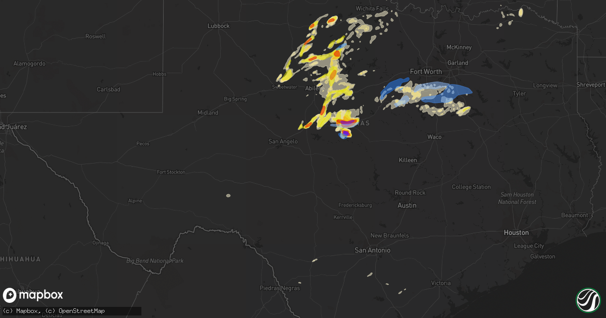
Hail Map in Texas on May 6, 2023
Get this storm
May 6 map
$229
one time, instant access
Download today. No call, no setup
Keep the $229
Bought the map and want the full workflow? Apply the entire $229 to a subscription within 7 days. None of it is wasted.
Every map, not just this one
This buys you this map. Subscription and you get every map we run, in the markets you choose from a few cities to whole states to nationwide. Plus real-time alerts the moment a storm fires.
Contact data
Name, contact info, occupancy, even credit band for addresses in the footprint. You go from where it hit to who to call.
Become the source they trust
Unlimited branding weather history reports on demand. You already have the documented answer ready for the property owner, and you are the one who showed up with it.
Property data and RoofTrace estimates
Pull up any address you have got, its value and the exact code rules for that jurisdiction, straight from One Click Code. Then RoofTrace estimates the squares, pitch, and roof value, priced the way you price.
Storm reports in Texas
Texas
| Date | Description |
|---|---|
| 05/06/20236:44 PM CDT | A local report indicates 1.00 inch wind near 11 NNW BROWNWOOD |
| 05/06/20236:44 PM CDT | Report from mping: quarter |
| 05/06/20236:38 PM CDT | Social media video of power flashes alongside the road. |
| 05/06/20236:35 PM CDT | Report from mping: golf ball |
| 05/06/20236:22 PM CDT | Spotter network report. Time estimated by radar. |
| 05/06/20236:20 PM CDT | A local report indicates 1.50 inch wind near ALBANY |
| 05/06/20236:05 PM CDT | Hail duration lasted for 30 minutes. |
| 05/06/20236:03 PM CDT | Report from mping: quarter |
| 05/06/20235:55 PM CDT | A local report indicates 1.00 inch wind near RULE |
| 05/06/20235:53 PM CDT | Quarter size hail at hords creek lake near coleman. |
| 05/06/20235:48 PM CDT | Law enforcement reports trees and signs blown down in benjamin. Time estimated by radar. |
| 05/06/20235:45 PM CDT | A local report indicates 1.75 inch wind near 2 WSW BENOIT |
| 05/06/20235:45 PM CDT | Found off of hwy 283. |
| 05/06/20235:45 PM CDT | Law enforcement report of hail to just smaller than golf-ball-sized. |
| 05/06/20235:43 PM CDT | A local report indicates 1.25 inch wind near 4 SE ECHO |
| 05/06/20235:42 PM CDT | A local report indicates 1.00 inch wind near 4 SE GLEN COVE |
| 05/06/20235:30 PM CDT | Mostly smaller hail but up to golf ball size was found. |
| 05/06/20235:29 PM CDT | A local report indicates 1.00 inch wind near 3 NW LONGWORTH |
| 05/06/20235:25 PM CDT | A local report indicates 1.75 inch wind near 2 N STAMFORD |
| 05/06/20235:24 PM CDT | A local report indicates 1.75 inch wind near 3 NW THRIFTY |
| 05/06/20235:23 PM CDT | A local report indicates 1.50 inch wind near 1 E BALLINGER |
| 05/06/20235:15 PM CDT | Half dollar to ping pong ball sized hail falling. |
| 05/06/20235:03 PM CDT | A local report indicates 1.75 inch wind near 3 NW SILVER VALLEY |
| 05/06/20235:02 PM CDT | Hail up to quarter size beginning to fall in downtown area. |
| 05/06/20234:37 PM CDT | Report from mping: half dollar |
| 05/06/202312:23 AM CDT | Report from mping: 3-inch tree limbs broken; power poles broken. |
| 05/05/202311:46 PM CDT | Report from mping: 3-inch tree limbs broken; power poles broken. |
| 05/05/202311:05 PM CDT | Social media report of trees snapped in mans best friend dog park in mansfield... Time estimated by radar. |
| 05/05/202310:38 PM CDT | A local report indicates 60 MPH wind near RIO VISTA |
| 05/05/202310:24 PM CDT | Report from mping: 1-inch tree limbs broken; shingles blown off. |
| 05/05/202310:15 PM CDT | A local report indicates 65 MPH wind near GODLEY |
| 05/05/202310:10 PM CDT | A local report indicates 65 MPH wind near 2 N WALNUT SPRINGS |
| 05/05/20239:55 PM CDT | Kgdj awos. |
| 05/05/20239:39 PM CDT | Report from mping: quarter |
| 05/05/20239:30 PM CDT | Off of fm 1176 south of brownwood. |
| 05/05/20239:15 PM CDT | Report from mping: baseball+ |
| 05/05/20238:56 PM CDT | Report from mping: tea cup |
| 05/05/20238:37 PM CDT | Time estimated from radar. |
| 05/05/20238:33 PM CDT | A local report indicates 68 MPH wind near 7 S BOWIE |
| 05/05/20238:20 PM CDT | Mostly quarters off of cr 155 south of bangs. |
| 05/05/20238:12 PM CDT | A local report indicates 2.00 inch wind near BLANKET |
| 05/05/20238:10 PM CDT | Report from mping: tennis ball |
| 05/05/20238:08 PM CDT | A local report indicates 74 MPH wind near 6 N BROWNWOOD |
| 05/05/20238:08 PM CDT | A local report indicates 74 MPH wind near 6 N BLANKET |
| 05/05/20238:08 PM CDT | A local report indicates 1.75 inch wind near BLANKET |
| 05/05/20238:07 PM CDT | Social media user sent in report on facebook. |
| 05/05/20238:05 PM CDT | A local report indicates 2.50 inch wind near 1 N EARLY |
| 05/05/20238:03 PM CDT | Tree blown over onto a home. Time estimated from radar. |
| 05/05/20238:02 PM CDT | A local report indicates 1.00 inch wind near BROWNWOOD |
| 05/05/20238:02 PM CDT | Report from mping: baseball |
| 05/05/20238:00 PM CDT | Corrects previous tstm wnd dmg report from jacksboro. 3 inch oak branches broken at fm2190 and jt graves lane northwest of jacksboro. |
| 05/05/20237:55 PM CDT | Kbwd awos reported 65 kt gust with thunderstorm. |
| 05/05/20237:51 PM CDT | 2-2.5 inch hail estimated to be falling near flat rock campground. |
| 05/05/20237:45 PM CDT | Up to golf ball sized hail. |
| 05/05/20237:44 PM CDT | Report from mping: quarter |
| 05/05/20237:22 PM CDT | Dime to golf ball sized hail falling. |
| 05/05/20237:21 PM CDT | Transformer damage reported in windthorst. |
| 05/05/20237:07 PM CDT | A local report indicates 59 MPH wind near 1 NE SHEPPARD AFB |
| 05/05/20237:01 PM CDT | Report from mping: half dollar |
| 05/05/20237:00 PM CDT | A local report indicates 70 MPH wind near THROCKMORTON |
All States Impacted by Hail Map on May 6, 2023
Cities Impacted by Hail Map on May 6, 2023
- Gonzales, LA
- Denham Springs, LA
- Saint Amant, LA
- Sorrento, LA
- Darrow, LA
- Prairieville, LA
- Baton Rouge, LA
- Geismar, LA
- French Settlement, LA
- Saint Gabriel, LA
- Livingston, LA
- Maurepas, LA
- Springfield, LA
- Gramercy, LA
- Garyville, LA
- Ponchatoula, LA
- La Place, LA
- Holden, LA
- Hammond, LA
- Madisonville, LA
- Donaldsonville, LA
- Paulina, LA
- Convent, LA
- Vacherie, LA
- Mount Airy, LA
- Saint James, LA
- Lutcher, LA
- Edgard, LA
- Hahnville, LA
- Reserve, LA
- Mandeville, LA
- Saint Rose, LA
- Luling, LA
- Metairie, LA
- Destrehan, LA
- Kenner, LA
- Ama, LA
- Covington, LA
- Abita Springs, LA
- Norco, LA
- New Orleans, LA
- Boutte, LA
- Lacombe, LA
- Westwego, LA
- Marrero, LA
- Harvey, LA
- Gretna, LA
- Chalmette, LA
- Arabi, LA
- Belle Chasse, LA
- Meraux, LA
- Slidell, LA
- Pearl River, LA
- White Castle, LA
- Carville, LA
- Picayune, MS
- Robert, LA
- Belle Rose, LA
- Paradis, LA
- Violet, LA
- Des Allemands, LA
- Braithwaite, LA
- Saint Bernard, LA
- Thibodaux, LA
- Gulfport, MS
- Stennis Space Center, MS
- Pass Christian, MS
- Kiln, MS
- Diamondhead, MS
- Waveland, MS
- Bay Saint Louis, MS
- Pearlington, MS
- Long Beach, MS
- Raceland, LA
- Lafitte, LA
- Cut Off, LA
- Port Sulphur, LA
- Lockport, LA
- Barataria, LA
- Frankford, MO
- Louisiana, MO
- Bowling Green, MO
- Pleasant Hill, IL
- Rockport, IL
- Clarksville, MO
- Nebo, IL
- Kampsville, IL
- Pearl, IL
- White Hall, IL
- Eldred, IL
- Carrollton, IL
- Franklin, LA
- Ethel, MO
- Bucklin, MO
- Ridgeway, MO
- Princeton, MO
- Theriot, LA
- Evergreen, LA
- Plaucheville, LA
- Morrow, LA
- Ville Platte, LA
- Washington, LA
- Moberly, MO
- Madison, MO
- Holliday, MO
- Stoutsville, MO
- Paris, MO
- Brookfield, MO
- Folsom, LA
- Green Castle, MO
- New London, MO
- Shelbina, MO
- Loreauville, LA
- Jeanerette, LA
- New Iberia, LA
- Cairo, MO
- Macon, MO
- Oakdale, LA
- Rutledge, MO
- Memphis, MO
- Callao, MO
- Atlanta, MO
- New Cambria, MO
- New Boston, MO
- Elmer, MO
- La Plata, MO
- Gibbs, MO
- Monroe City, MO
- Kirksville, MO
- Perry, MO
- Baldwin, LA
- Ashburn, MO
- Center, MO
- Curryville, MO
- New Canton, IL
- Kinderhook, IL
- Novinger, MO
- Auxvasse, MO
- Columbia, MO
- Bunkie, LA
- Hamburg, IA
- Farragut, IA
- Riverton, IA
- Peru, NE
- Watson, MO
- Rock Port, MO
- Tarkio, MO
- Westboro, MO
- Hamlin, TX
- Stamford, TX
- Valera, TX
- Talpa, TX
- Coleman, TX
- Skidmore, MO
- Maryville, MO
- Throckmorton, TX
- Aspermont, TX
- Old Glory, TX
- Rule, TX
- Novice, TX
- Bangs, TX
- Santa Anna, TX
- Brownwood, TX
- Elmo, MO
- Clyde, TX
- Miles, TX
- Ballinger, TX
- Norton, TX
- Seymour, TX
- Rochester, TX
- O'Brien, TX
- Rotan, TX
- Sweetwater, TX
- Roby, TX
- Barnard, MO
- Conception Junction, MO
- Burlington Junction, MO
- Clearmont, MO
- Blanchard, IA
- Hopkins, MO
- Burkett, TX
- Haskell, TX
- Clyde, MO
- Conception, MO
- Stanberry, MO
- Benjamin, TX
- Baird, TX
- Cross Plains, TX
- Johnstown, NE
- Ainsworth, NE
- Long Pine, NE
- Bassett, NE
- Albany, MO
- Guilford, MO
- Cody, NE
- Wanblee, SD
- Simmesport, LA
- Kyle, SD
- Howes, SD
- Morgan City, LA
- Wounded Knee, SD
- Batesland, SD
- Martin, SD
- Allen, SD
- Porcupine, SD
- Dulac, LA
- Chauvin, LA
- Montegut, LA
- Midland, SD
- Raymond, IL
- Carlinville, IL
- Nilwood, IL
- Waggoner, IL
- Girard, IL
- Morganza, LA
- New Roads, LA
- Waseca, MN
- New Richland, MN
- Enning, SD
- White Owl, SD
- Gibson, LA
- Melville, LA
- Lettsworth, LA
- Palmetto, LA
- Batchelor, LA
- Rushville, NE
- Lakeland, LA
- Oscar, LA
- Erwinville, LA
- Jarreau, LA
- Palisade, NE
- Wauneta, NE
- Hayes Center, NE
- Bingham, IL
- Fillmore, IL
- Ravenwood, MO
- Maitland, MO
- Mound City, MO
- Valentine, NE
- Cisne, IL
- Mount Erie, IL
- Harvel, IL
- Milesville, SD
- Belle Fourche, SD
- Cherry Creek, SD
- Goodhue, MN
- Litchfield, IL
- Golden Meadow, LA
- Grand Isle, LA
- Livonia, LA
- Ventress, LA
- Newell, SD
- Port Allen, LA
- Hillsboro, IL
- Irving, IL
- Flora, IL
- Shipman, IL
- Gillespie, IL
- Schriever, LA
- Ramsey, IL
- Hulett, WY
- Bunker Hill, IL
- Medora, IL
- Mount Olive, IL
- Chesterfield, IL
- Benld, IL
- Altamont, IL
- Cowden, IL
- Saint Elmo, IL
- Beecher City, IL
- Rinard, IL
- Clay City, IL
- Coffeen, IL
- Witt, IL
- New Underwood, SD
- Rockbridge, IL
- Butler, IL
- Kane, IL
- Taylor Springs, IL
- Sawyerville, IL
- Fieldon, IL
- West Salem, IL
- Nokomis, IL
- Oconee, IL
- Staunton, IL
- Walshville, IL
- Mulberry Grove, IL
- Vandalia, IL
- Mason, IL
- Brownstown, IL
- Albany, TX
- Sylvester, TX
- Newport, NE
- Darlington, MO
- McCaulley, TX
- Sacred Heart, MN
- Clara City, MN
- Raymond, MN
- Renville, MN
- Prinsburg, MN
- Willmar, MN
- Stuart, NE
- Bethany, MO
- McFall, MO
- New Hampton, MO
- Pattonsburg, MO
- Coffey, MO
- Thedford, NE
- Seneca, NE
- May, TX
- Davidson, OK
- Elsmere, NE
- Rising Star, TX
- Gilman City, MO
- Frederick, OK
- Jameson, MO
- Jamesport, MO
- Hollister, OK
- Gallatin, MO
- Trenton, MO
- King City, MO
- Loveland, OK
- Abilene, TX
- Laredo, MO
- Indiahoma, OK
- Chattanooga, OK
- Cache, OK
- Faxon, OK
- Snyder, OK
- Early, TX
- Blanket, TX
- Lawton, OK
- Chillicothe, MO
- Chula, MO
- Linneus, MO
- Wheeling, MO
- Browning, MO
- Humphreys, MO
- Purdin, MO
- Galt, MO
- Meadville, MO
- Laclede, MO
- Blue Hill, NE
- Glenvil, NE
- Lawrence, NE
- Fairfield, NE
- Cisco, TX
- Deweese, NE
- Edgar, NE
- Ong, NE
- Nelson, NE
- Oak, NE
- Davenport, NE
- Brookesmith, TX
- Winigan, MO
- Bruning, NE
- Shickley, NE
- Carleton, NE
- Stephenville, TX
- Bluff Dale, TX
- Tolar, TX
- Lipan, TX
- Santo, TX
- Granbury, TX
- Weatherford, TX
- Belvidere, NE
- Deshler, NE
- Hebron, NE
- Daykin, NE
- Ohiowa, NE
- Western, NE
- Alexandria, NE
- Tobias, NE
- Gilead, NE
- Fairbury, NE
- Plymouth, NE
- Jansen, NE
- De Witt, NE
- Hico, TX
- Walnut Springs, TX
- Marceline, MO
- Excello, MO
- Jacksonville, MO
- Bevier, MO
- Mount Sterling, IA
- Bonaparte, IA
- Keosauqua, IA
- West Burlington, IA
- Danville, IA
- Middletown, IA
- Burlington, IA
- Wever, IA
- Arbela, MO
- Luray, MO
- Kahoka, MO
- Glen Rose, TX
- Rainbow, TX
- Douds, IA
- Birmingham, IA
- Milton, IA
- Cantril, IA
- Stockport, IA
- Selma, IA
- Eldon, IA
- Floris, IA
- Bloomfield, IA
- Anabel, MO
- Clarence, MO
- Godley, TX
- Cleburne, TX
- Joshua, TX
- Nemo, TX
- Lentner, MO
- Batavia, IA
- Libertyville, IA
- Fairfield, IA
- Rio Vista, TX
- Blum, TX
- Covington, TX
- Grandview, TX
- Itasca, TX
- Attica, IN
- Williamsport, IN
- Perrysville, IN
- Covington, IN
- Alvarado, TX
- Burleson, TX
- Mansfield, TX
- Lillian, TX
- Venus, TX
- Midlothian, TX
- Milford, TX
- Italy, TX
- Waxahachie, TX
- Maypearl, TX
- Forreston, TX
- Waurika, OK
- Ryan, OK
- Petrolia, TX
- Byers, TX
- Breckenridge, TX
- Wabasha, MN
- Ideal, SD
- Drakesville, IA
- Moran, TX
- Henrietta, TX
- Bellevue, TX
- Bowie, TX
- Sturgis, SD
- Ozona, TX
- Wood Lake, NE
- Springview, NE
- Independence, WI
- Whitehall, WI
- Hanley Falls, MN
- Granite Falls, MN
- Woodson, TX
- Atkinson, NE
- Vale, SD
- Zumbrota, MN
- Wanamingo, MN
- Munday, TX
- Knox City, TX
- Crowell, TX
- Nocona, TX
- Ringgold, TX
- Blomkest, MN
- Mazeppa, MN
- Lake City, MN
- Vernon, TX
- Beatrice, NE
- Hennepin, OK
- Holliday, TX
- Baker, LA
- Naper, NE
- Avoca, TX
- Wichita Falls, TX
- Olney, TX
- Wood, SD
- Winner, SD
- Winnett, MT
- Farnam, NE
- Eustis, NE
- Bertrand, NE
- Smithfield, NE
- Curtis, NE
- Elwood, NE
- Stockville, NE
- Moorefield, NE
- Alma, WI
- Holstein, NE
- Loomis, NE
- Holdrege, NE
- Clay Center, NE
- Roseland, NE
- Bladen, NE
- Minden, NE
- Campbell, NE
- Wilcox, NE
- Funk, NE
- Ayr, NE
- Axtell, NE
- Hildreth, NE
- Sutton, NE
- Elgin, OK
- Dublin, TX
- Martinsville, MO
- Newcastle, TX
- Comanche, TX
- De Leon, TX
- Goree, TX
- Jacksboro, TX
- Mills, NE
- Archer City, TX
- Windthorst, TX
- Red Wing, MN
- Hawley, TX
- Anson, TX
- Gregory, SD
- Hamill, SD
- Oklaunion, TX
- Arapahoe, NE
- Geneva, NE
- Ogallala, NE
- Wasta, SD
- Arcadia, WI
- Gentry, MO
- Loving, TX
- Millville, MN
- Scotland, TX
- Lake Lillian, MN
- Merkel, TX
- Nelson, WI
- Maywood, NE
- Ringling, OK
- Loco, OK
- Harrold, TX
- Milan, MO
- Graham, MO
- Mondovi, WI
- Lueders, TX
- Glynn, LA
- Kenyon, MN
- Sidney, TX
- Shelbyville, MO
- Lockridge, IA
- Bethel, MO
- Ennis, TX
- Palmer, TX
- Ferris, TX
- Red Oak, TX
- Cedar Hill, TX
- Remington, IN
- Wolcott, IN
- Fowler, IN
- Reynolds, IN
- Kemp, TX
- Scurry, TX
- Rosser, TX
- Pittsburg, OK
- Stuart, OK
- Kiowa, OK
- Mcalester, OK
- Blanco, OK
- Savanna, OK
- Krebs, OK
- Tuskahoma, OK
- Haileyville, OK
- Hartshorne, OK
- Wilburton, OK
- Red Oak, OK
- Quinton, OK
- Eufaula, OK
- Talihina, OK
- Wister, OK
- Kinta, OK
- Brighton, IA
- Wayland, IA
- Washington, IA
- Chandlerville, IL
- Oakford, IL
- Petersburg, IL
- Shady Point, OK
- Bokoshe, OK
- Mccurtain, OK
- Keota, OK
- Stigler, OK
- Porum, OK
- Whitefield, OK
- Mount Pleasant, IA
- Crawfordsville, IA
- Glenwood, MO
- Livonia, MO
- Coatsville, MO
- Lancaster, MO
- Downing, MO
- Greenview, IL
- Athens, IL
- Veedersburg, IN
- Lebanon, IN
- Whitestown, IN
- Mount Union, IA
- Pulaski, IA
- Spiro, OK
- Corsicana, TX
- Atlanta, IN
- Elwood, IN
- Tipton, IN
- Farmington, IA
- Peoria, IL
- Edwards, IL
- Peoria Heights, IL
- Wall, SD
- Le Roy, IL
- Sargent, NE
- Comstock, NE
- Burwell, NE
- Elyria, NE
- Bartlett, NE
- Caroline, WI
- Paris, TX
- Powderly, TX
- Roxton, TX
- Brookston, TX
- Roachdale, IN
- Bainbridge, IN
- Russellville, IN
- Greencastle, IN
- Caddo, TX
- Pekin, IL
- Groveland, IL
- Indianapolis, IN
- Brownsburg, IN
- Rensselaer, IN
- Francesville, IN
- Tolono, IL
- Darlington, IN
- Ingomar, MT
- Musselshell, MT
- Zionsville, IN
- Pittsboro, IN
- Broken Bow, OK
- Purdon, TX
- Barry, TX
- Coalgate, OK
- Wardville, OK
- Atoka, OK
- Roseville, IL
- Galesburg, IL
- Berwick, IL
- Abingdon, IL
- Cameron, IL
- Monmouth, IL
- Gilson, IL
- Maquon, IL
- Lomax, IL
- Dallas City, IL
- La Harpe, IL
- Mount Pulaski, IL
- Latham, IL
- Warrensburg, IL
- Middletown, IL
- New Holland, IL
- Lincoln, IL
- Beason, IL
- Maroa, IL
- Elkhart, IL
- Chestnut, IL
- Clinton, IL
- Kenney, IL
- Metamora, IL
- Roanoke, IL
- Benson, IL
- South English, IA
- Mediapolis, IA
- Morning Sun, IA
- Wapello, IA
- Keithsburg, IL
- Oakville, IA
- Rattan, OK
- Warsaw, IL
- Basco, IL
- Danville, IL
- Sadorus, IL
- Monticello, IL
- Ivesdale, IL
- Bement, IL
- Fithian, IL
- Hillsboro, IA
- Chalmers, IN
- Easton, IL
- Junction City, WI
- Stevens Point, WI
- Detroit, TX
- Bagwell, TX
- Shawano, WI
- Marion, WI
- Minonk, IL
- Monticello, IN
- Idaville, IN
- Star City, IN
- Monon, IN
- Burnettsville, IN
- Cisco, IL
- Argenta, IL
- Riverside, IA
- Wellman, IA
- Kalona, IA
- Parnell, IA
- Mason City, IL
- Lewistown, IL
- Cuba, IL
- Crawfordsville, IN
- Winamac, IN
- Royal Center, IN
- Brookston, IN
- Rushville, IL
- Frederick, IL
- Mount Sterling, IL
- Creve Coeur, IL
- Mosinee, WI
- Custer, WI
- Rosholt, WI
- Canadian, OK
- Elmwood, IL
- Yates City, IL
- Trivoli, IL
- Tallula, IL
- Beardstown, IL
- Ashland, IL
- Virginia, IL
- Queen City, MO
- Hillsboro, TX
- Beverly Shores, IN
- La Porte, IN
- Michigan City, IN
- Blandinsville, IL
- East Peoria, IL
- Washington, IL
- Daisy, OK
- Stringtown, OK
- Milford, IL
- Frost, TX
- Blooming Grove, TX
- Bethel, OK
- Arcadia, IN
- Kingman, IN
- Sumner, TX
- Rochester, IN
- Nashoba, OK
- Hugo, OK
- New Market, IN
- New Ross, IN
- Advance, IN
- Jamestown, IN
- Ladoga, IN
- Carbon, TX
- Snow, OK
- Thorntown, IN
- Newark, MO
- West Point, IA
- Fort Madison, IA
- Ashkum, IL
- Logansport, IN
- Twelve Mile, IN
- Lucerne, IN
- Carthage, IL
- Green Valley, IL
- Manito, IL
- San Jose, IL
- Macomb, IL
- Denmark, IA
- Atwood, OK
- Holdenville, OK
- Dewey, IL
- Liverpool, IL
- Canton, IL
- Donnellson, IA
- Champaign, IL
- Worthington, MO
- Wayland, MO
- Watson, OK
- Ludlow, IL
- Watseka, IL
- Sheldon, IL
- Whitney, TX
- Salem, IA
- Chillicothe, IL
- Dunlap, IL
- Edelstein, IL
- Leonard, MO
- Glasford, IL
- Mapleton, IL
- Dana, IL
- Minier, IL
- Hopedale, IL
- Hanna City, IL
- Ridge Farm, IL
- Keota, IA
- Iowa City, IA
- North English, IA
- Crowley, TX
- Kopperl, TX
- Keene, TX
- Cresson, TX
- Mahomet, IL
- Brimfield, IL
- Forest City, IL
- Chesterton, IN
- Bryant, IL
- Clifton, IL
- Industry, IL
- Plymouth, IL
- Colchester, IL
- Adair, IL
- Table Grove, IL
- Valliant, OK
- Westville, IL
- Rice, TX
- Eastland, TX
- Elgin, NE
- Clearwater, NE
- Oakdale, NE
- Ord, NE
- Ericson, NE
- Broken Bow, NE
- Merna, NE
- Tilden, NE
- Allerton, IL
- Broadlands, IL
- Homer, IL
- Sidell, IL
- Martin, MI
- Shelbyville, MI
- Hopkins, MI
- Tuscola, IL
- Medaryville, IN
- Laura, IL
- Fennville, MI
- Sidney, IL
- Saint Joseph, IL
- Philo, IL
- Urbana, IL
- Ogden, IL
- Casey, IL
- Goodland, IN
- Avon, IN
- Danville, IN
- Metcalf, IL
- Chrisman, IL
- Bloomington, IL
- Bellflower, IL
- Farmer City, IL
- Allegan, MI
- Otsego, MI
- Oldenburg, IN
- Batesville, IN
- Petersburg, NE
- Ewing, NE
- Meadow Grove, NE
- Mertens, TX
- Bynum, TX
- Argyle, IA
- Trenton, OH
- Middletown, OH
- Somerville, OH
- Waynetown, IN
- Kempton, IN
- Clarks Hill, IN
- Waveland, IN
- Alamo, IN
- North Salem, IN
- Sheridan, IN
- New Richmond, IN
- Frankfort, IN
- Linden, IN
- Kirklin, IN
- Turners Station, KY
- Kentland, IN
- Danvers, IL
- Mackinaw, IL
- Centerpoint, IN
- Malone, TX
- Abbott, TX
- Oakwood, IL
- Otterbein, IN
- Oxford, IN
- Smithshire, IL
- North Henderson, IL
- Alexis, IL
- Waynesville, IL
- Wapella, IL
- Rantoul, IL
- Goodfield, IL
- Mansfield, IL
- Heyworth, IL
- Carlock, IL
- Shirley, IL
- Deer Creek, IL
- Arrowsmith, IL
- Downs, IL
- Tremont, IL
- Normal, IL
- Delavan, IL
- Congerville, IL
- Morton, IL
- South Pekin, IL
- Stanford, IL
- Frankton, IN
- Alexandria, IN
- Hamilton, MI
- Earl Park, IN
- Ellisville, IL
- Bushnell, IL
- Smithfield, IL
- Avon, IL
- Marietta, IL
- Martinsville, IL
- Westfield, IL
- Gosport, IN
- Paragon, IN
- Connersville, IN
- Muncie, IN
- Yorktown, IN
- Gaston, IN
- Armington, IL
- McLean, IL
- Paxton, IL
- Cerro Gordo, IL
- Villa Grove, IL
- Decatur, IL
- Milmine, IL
- Atwood, IL
- Hammond, IL
- Arcola, IL
- Oreana, IL
- Pesotum, IL
- Greenup, IL
- Martinsville, IN
- Cloverdale, IN
- Quincy, IN
- Hillsdale, IN
- Dana, IN
- Cayuga, IN
- Bath, IN
- Oxford, OH
- Brookville, IN
- West College Corner, IN
- De Land, IL
- Westfield, IN
- Newman, IL
- Seymour, IL
- Aledo, IL
- Joy, IL
- Seaton, IL
- Fisher, IL
- Foosland, IL
- Camden, OH
- Unionville, MO
- Liberty, IN
- Madison, IN
- Donovan, IL
- Iroquois, IL
- Topeka, IL
- Knightstown, IN
- Carthage, IN
- Canaan, IN
- Neligh, NE
- Sciota, IL
- Niota, IL
- Bismarck, IL
- Alvin, IL
- Wataga, IL
- Eaton, IN
- Good Hope, IL
- Prairie City, IL
- Bardolph, IL
- Saint David, IL
- Strawn, TX
- Braddyville, IA
- Greenfield, IN
- Wilkinson, IN
- Liberty Center, IN
- Warren, IN
- Summitville, IN
- Hidalgo, IL
- Covert, MI
- Watervliet, MI
- Reelsville, IN
- Poland, IN
- Brazil, IN
- Hamilton, OH
- Shelbyville, IN
- Lewisville, IN
- Straughn, IN
- New Castle, IN
- Seymour, IN
- Huntington, IN
- Bennington, IN
- Charleston, IL
- Kempton, IL
- Boswell, IN
- Rio, IL
- Wayland, MI
- Campbellton, TX
- Beeville, TX
- Kenedy, TX
- Jourdanton, TX
- Pleasanton, TX
- Uvalde, TX
- Campbellsburg, KY
- Milton, KY
- Saugatuck, MI
- Dry Ridge, KY
- Crittenden, KY
- Lynchburg, OH
- Hillsboro, OH
- Coloma, MI
- Hartford, MI
- Bangor, MI
- Longview, IL
- Ellsworth, IL
- Warsaw, KY
- Glencoe, KY
- Patriot, IN
- Verona, KY
- Williamstown, KY
- Saint Paul, IA
- Florence, IN
- Rising Sun, IN
- Plainwell, MI
- Gorman, TX
- Crystal City, TX


