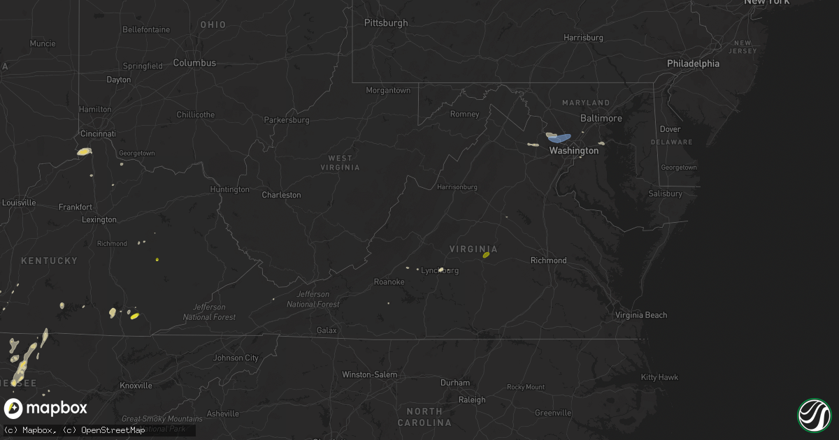
Hail Map in Virginia on May 2, 2019
Get this storm
May 2 map
$229
one time, instant access
Download today. No call, no setup
Keep the $229
Bought the map and want the full workflow? Apply the entire $229 to a subscription within 7 days. None of it is wasted.
Every map, not just this one
This buys you this map. Subscription and you get every map we run, in the markets you choose from a few cities to whole states to nationwide. Plus real-time alerts the moment a storm fires.
Contact data
Name, contact info, occupancy, even credit band for addresses in the footprint. You go from where it hit to who to call.
Become the source they trust
Unlimited branding weather history reports on demand. You already have the documented answer ready for the property owner, and you are the one who showed up with it.
Property data and RoofTrace estimates
Pull up any address you have got, its value and the exact code rules for that jurisdiction, straight from One Click Code. Then RoofTrace estimates the squares, pitch, and roof value, priced the way you price.
Storm reports in Virginia
Virginia
| Date | Description |
|---|---|
| 05/02/20195:32 PM CDT | Quarter inch hail in gold hill on route 15. |
| 05/02/20194:21 PM CDT | Quarter size hail reported at lee and moss grocery store. Time from radar. |
| 05/02/20193:25 PM CDT | Tree down on spotswood trail near constitution ave. |
| 05/02/20192:38 PM CDT | Tree down with power lines down on spring vale avenue |
| 05/02/20192:10 PM CDT | Tree down on power lines. Time estimated by radar. |
| 05/02/20192:05 PM CDT | Tree reported down on fairway drive near algonkian parkway. |
| 05/02/20192:05 PM CDT | Tree reported down on fairway drive near algonkian parkway. |
| 05/02/20191:40 PM CDT | Corrects previous tstm wnd dmg report from 4 wnw rocky mount. 4 trees down on blankenship rd. Time estimated by radar. |
| 05/02/201912:14 AM CDT | At 513 PM EDT, a severe thunderstorm was located over Madison Heights, moving northeast at 15 mph. HAZARD...60 mph wind gusts and quarter size hail. SOURCE...Radar indicated. IMPACT...Hail damage to vehicles is expected. Expect wind damage to roofs, siding, and trees. Locations impacted include... Lynchburg... Amherst... Bent Creek... Madison Heights... and Falconerville.This includes The following Location Liberty University. |
| 05/01/201911:56 PM CDT | At 455 PM EDT, a severe thunderstorm was located near Louisa, moving east at 15 mph. HAZARD...60 mph wind gusts. SOURCE...Radar indicated. IMPACT...Damaging winds will cause some trees and large branches to fall. This could injure those outdoors, as well as damage homes and vehicles. Roadways may become blocked by downed trees. Localized power outages are possible. Unsecured light objects may become projectiles. Locations impacted include... Glenora, Thornhill and Lahore. |
| 05/01/201911:52 PM CDT | At 451 PM EDT, a severe thunderstorm was located near Boswells Tavern, or near Louisa, moving east at 20 mph. HAZARD...60 mph wind gusts and quarter size hail. SOURCE...Radar indicated. IMPACT...Minor damage to vehicles is possible. Expect wind damage to trees and powerlines. This severe thunderstorm will be near, Louisa around 500 PM EDT.Other locations impacted by this severe thunderstorm include WaresCrossroads, Louisa Airport, Vawter Corner, Green Springs andTrevilians. |
| 05/01/201911:12 PM CDT | At 411 PM EDT, a severe thunderstorm was located over Peaks Of Otter Summit, moving northeast at 15 mph. HAZARD...60 mph wind gusts and quarter size hail. SOURCE...Radar indicated. IMPACT...Hail damage to vehicles is expected. Expect wind damage to roofs, siding, and trees. Locations impacted include... Buchanan... Glasgow... Big Island... Coleman Falls... and Snowden. |
All States Impacted by Hail Map on May 2, 2019
Cities Impacted by Hail Map on May 2, 2019
- Murfreesboro, TN
- Pollok, TX
- Baird, TX
- Union, KY
- Verona, KY
- Warsaw, KY
- Walton, KY
- Patriot, IN
- Cisco, TX
- Comstock, TX
- Del Rio, TX
- Valley Mills, TX
- Bloomington Springs, TN
- Smiths Grove, KY
- Park City, KY
- Boonville, IN
- Tennyson, IN
- Chrisney, IN
- Ridgely, TN
- Lebanon, TN
- Mount Juliet, TN
- Eastland, TX
- Fort Stockton, TX
- Hartford, KY
- Beaver Dam, KY
- Eden, TX
- Dryden, TX
- Carbon, TX
- Anson, TX
- Milano, TX
- Dickerson, MD
- Germantown, MD
- Poolesville, MD
- Great Falls, VA
- Leesburg, VA
- Potomac, MD
- Ashburn, VA
- Sterling, VA
- Barbourville, KY
- Rockholds, KY
- Wadesville, IN
- May, TX
- Sidney, TX
- Cynthiana, KY
- Cleburne, TX
- New Harmony, IN
- Poseyville, IN
- Richland, IN
- Buffalo Valley, TN
- Silver Point, TN
- Baxter, TN
- Coleman, TX
- Winters, TX
- Talpa, TX
- Valera, TX
- Ballinger, TX
- Russell Springs, KY
- Jamestown, KY
- Carlton, TX
- Dublin, TX
- Ordway, CO
- Brackettville, TX
- Troy, TN
- Whitesville, KY
- Utica, KY
- Fredericksburg, TX
- Morgantown, KY
- Brownsville, KY
- Iraan, TX
- Sheffield, TX
- Big Wells, TX
- Huntsville, TX
- Cameron, TX
- Comanche, TX
- Blanket, TX
- Hornbeak, TN
- De Leon, TX
- Smithville, TN
- Laredo, TX
- Mirando City, TX
- Gatesville, TX
- Lawn, TX
- Goldsboro, TX
- Lynchburg, VA
- Madison Heights, VA
- Abilene, TX
- Parkers Lake, KY
- Corbin, KY
- Bedias, TX
- Beattyville, KY
- Jackson, KY
- Gallatin, TN
- Christoval, TX
- Eldorado, TX
- Rising Star, TX
- Gainesboro, TN
- Owensville, IN
- Philpot, KY
- Rochester, KY
- Drakesboro, KY
- Livermore, KY
- Fordsville, KY
- Hawesville, KY
- Reynolds Station, KY
- Olaton, KY
- Centertown, KY
- Celina, TN
- Allons, TN
- Burkesville, KY
- Elkton, KY
- Cave City, KY
- Corydon, KY
- Henderson, KY
- Hickman, KY
- Rocky Mount, VA
- Santa Anna, TX
- Boone, CO
- Olney Springs, CO
- Princeton, IN
- Fort Branch, IN
- Scottsville, KY
- Adolphus, KY
- Blackwell, TX
- Weinert, TX
- Elmwood, TN
- Gordonsville, VA
- Goldthwaite, TX
- Hillsboro, TX
- Whitney, TX
- Riesel, TX
- Waco, TX
- Timpson, TX
- Hearne, TX
- Ovalo, TX
- Glen Rose, TX
- Bryan, TX
- Crawford, TX
- Hendersonville, TN
- Sonora, TX
- Natchitoches, LA
- Oilton, TX
- San Ygnacio, TX
- Bruni, TX
- Zapata, TX
- Hebbronville, TX
- Aldie, VA
- Middleburg, VA
- The Plains, VA
- Junction, TX
- Moran, TX
- Clyde, TX
- Albany, TX
- Mount Vernon, IN
- Cross Plains, TX
- Iola, TX
- Mcminnville, TN
- Morrison, TN
- Red Boiling Springs, TN
- Whitleyville, TN
- Pleasant Shade, TN
- Lafayette, TN
- Gorman, TX
- Menard, TX
- Fulton, KY
- Wingo, KY
- Hayti, MO
- Tiptonville, TN
- Clinton, KY
- Caruthersville, MO
- Union City, TN
- Stephenville, TX
- Stanton, KY
- Rockdale, TX
- Hardyville, KY
- Horse Cave, KY
- Brady, TX
- Comfort, TX
- Kerrville, TX
- San Saba, TX
- McGregor, TX
- London, TX
- Mason, TX
- Hico, TX
- Malone, TX
- Calvert, TX
- Sylvester, TX
- Francisco, IN
- Petersburg, IN
- Otwell, IN
- Velpen, IN
- Jasper, IN
- Winslow, IN
- Nolan, TX
- Walnut Springs, TX
- Iredell, TX
- Meridian, TX
- Lexington, TX
- Frenchburg, KY
- Haubstadt, IN
- Cotulla, TX
- Nacogdoches, TX
- Lancaster, TN
- Granville, TN
- Dowelltown, TN
- Hilham, TN
- Buffalo, TX
- Temple Hills, MD
- Merkel, TX
- Hawley, TX
- Gray, KY
- Cookeville, TN
- Novice, TX
- Voss, TX
- Davidsonville, MD
- Annapolis, MD
- Crownsville, MD
- Gambrills, MD
- Bedford, VA
- Montvale, VA
- Clifton, TX
- Sweetwater, TX
- Trent, TX
- Steele, MO
- Harper, TX
- Cushing, TX
- Concord, VA
- Glasgow, KY
- Garrison, TX
- Vancourt, TX
- Portageville, MO
- Ranger, TX
- College Station, TX
- Woodbine, KY
- Evansville, IN
- Cynthiana, IN
- Laughlin Afb, TX
- Cedar Bluff, VA
- Sparta, TN
- Melvin, TX
- Marquez, TX
- Williamstown, KY
- Carmi, IL
- Hopkinsville, KY
- Monticello, KY
- Brownwood, TX
- Blytheville, AR
- Rochelle, TX
- Richland Springs, TX
- Oglesby, TX
- Haskell, TX
- Carthage, TN
- Ravenna, KY
- Clay City, KY
- Evant, TX
- Purmela, TX
- Washington, DC
- Burtonsville, MD
- Laurel, MD
- Gause, TX
- Thrall, TX
- Elgin, TX
- Foster, KY
- Brooksville, KY
- Patoka, IN
- Mount Carmel, IL
- Desdemona, TX
- Horse Branch, KY
- Little Rock, AR
- Mabelvale, AR
- Sherwood, AR
- Jacksonville, AR
- Cabot, AR
- Des Arc, AR
- Dillwyn, VA
- New Canton, VA
- Arvonia, VA
- Kensington, MD
- Herndon, VA
- Gaithersburg, MD
- Rockville, MD
- Reston, VA
- Bethesda, MD


