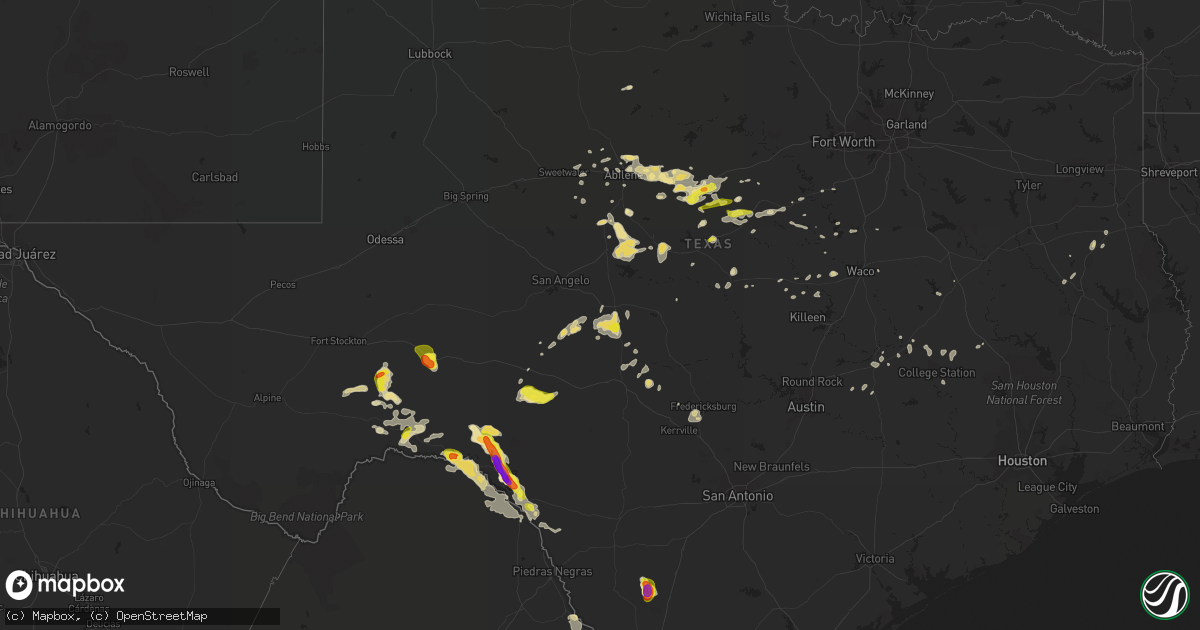
Hail Map in Texas on May 2, 2019
Get this storm
May 2 map
$229
one time, instant access
Download today. No call, no setup
Keep the $229
Bought the map and want the full workflow? Apply the entire $229 to a subscription within 7 days. None of it is wasted.
Every map, not just this one
This buys you this map. Subscription and you get every map we run, in the markets you choose from a few cities to whole states to nationwide. Plus real-time alerts the moment a storm fires.
Contact data
Name, contact info, occupancy, even credit band for addresses in the footprint. You go from where it hit to who to call.
Become the source they trust
Unlimited branding weather history reports on demand. You already have the documented answer ready for the property owner, and you are the one who showed up with it.
Property data and RoofTrace estimates
Pull up any address you have got, its value and the exact code rules for that jurisdiction, straight from One Click Code. Then RoofTrace estimates the squares, pitch, and roof value, priced the way you price.
Storm reports in Texas
Texas
| Date | Description |
|---|---|
| 05/02/20195:57 PM CDT | A local report indicates 1.75 inch wind near SHEFFIELD |
| 05/02/20195:20 PM CDT | A local report indicates 1.50 inch wind near SHEFFIELD |
| 05/02/20195:17 PM CDT | A local report indicates 1.00 inch wind near 1 E SHEFFIELD |
| 05/02/20191:42 PM CDT | Quarter size hail reported in de leon |
| 05/02/20191:35 PM CDT | A local report indicates 1.00 inch wind near 3 NW BLANKET |
| 05/02/20191:22 PM CDT | Hams report via phone call. Quarter size hail reported on hwy 6 between gorman and de leon |
| 05/02/201912:20 PM CDT | Late report: hail between the the size of quarters and golf balls reported along highway 60 between pampa and miami. Time estimated by radar |
| 05/02/20197:58 AM CDT | At 1258 AM CDT, a severe thunderstorm was located 4 miles south of Kingsmill, or 9 miles southwest of Pampa, moving east at 20 mph. HAZARD...Ping pong ball size hail and 60 mph wind gusts. SOURCE...Radar indicated. IMPACT...Minor damage to roofs, siding, and trees is possible. People and animals outdoors will be injured. Expect hail damage to roofs, siding, windows, and vehicles. Locations impacted include... Pampa, Lefors and Kingsmill. |
| 05/02/20197:52 AM CDT | At 1251 PM CDT, a severe thunderstorm was located 13 miles southwest of Sonora, moving northeast at 5 mph. HAZARD...Ping pong ball size hail and 60 mph wind gusts. SOURCE...Radar indicated. IMPACT...People and animals outdoors will be injured. Expect hail damage to roofs, siding, windows, and vehicles. Expect wind damage to roofs, siding, and trees. This severe thunderstorm will remain over mainly rural areas of western Sutton County, including the following locations... The Intersection Of Us-277 And Ranch Road 189.This includes Interstate 10 between Mile Markers 395 and 403. |
| 05/02/20197:44 AM CDT | At 1244 AM CDT, a severe thunderstorm was located 9 miles northeast of Lefors, or 12 miles south of Miami, moving southeast at 25 mph. HAZARD...60 mph wind gusts and half dollar size hail. SOURCE...Radar indicated. IMPACT...Minor damage to roofs, siding, and trees is possible. Hail damage to vehicles is expected. Locations impacted include... Briscoe, Lefors, New Mobeetie, Kellerville and Mobeetie. |
| 05/02/20197:36 AM CDT | At 1236 PM CDT, a severe thunderstorm was located 8 miles north of Rising Star, or 12 miles south of Cisco, moving southeast at 40 mph. HAZARD...60 mph wind gusts and quarter size hail. SOURCE...Radar indicated. IMPACT...Hail damage to vehicles is expected. Expect wind damage to roofs, siding, and trees. Locations impacted include... Eastland, De Leon, Gorman, Rising Star and Carbon. This includes Interstate 20 between mile markers 336 and 342. |
| 05/02/20197:27 AM CDT | At 1227 AM CDT, a severe thunderstorm was located 5 miles northwest of White Deer, or 12 miles northeast of Panhandle, moving east at 20 mph. HAZARD...60 mph wind gusts and half dollar size hail. SOURCE...Radar indicated. IMPACT...Minor damage to roofs, siding, and trees is possible. Hail damage to vehicles is expected. Locations impacted include... Pampa, White Deer, Skellytown and Kingsmill. |
| 05/02/20197:05 AM CDT | At 1205 AM CDT, a severe thunderstorm was located near Codman, or 9 miles west of Miami, moving east at 20 mph. HAZARD...60 mph wind gusts and quarter size hail. SOURCE...Radar indicated. IMPACT...Minor damage to roofs, siding, and trees is possible. Hail damage to vehicles is expected. Locations impacted include... Miami, Codman and Lora. |
| 05/02/20196:45 AM CDT | Light pole blown down on highway 359 in oilton. |
| 05/02/20196:29 AM CDT | At 1129 PM CDT, a severe thunderstorm was located near Langtry, moving east at 15 mph. HAZARD...Quarter size hail. SOURCE...Radar indicated. IMPACT...Damage to vehicles is expected. Locations impacted include... Langtry, Shumla, Osman, Seminole Canyon State Park and Amistad Recreation Area - Pecos River Boat Ramp. |
| 05/02/20195:56 AM CDT | At 1056 PM CDT, a severe thunderstorm was located near Lake View, or near Del Rio, moving southeast at 25 mph. HAZARD...Golf ball size hail and 60 mph wind gusts. SOURCE...Radar indicated. IMPACT...People and animals outdoors will be injured. Expect hail damage to roofs, siding, windows, and vehicles. Expect wind damage to roofs, siding, and trees. Locations impacted include... Del Rio, Lake View, Amistad Village, Amistad Recreation Area - Governors Landing, Amistad Recreation Area - Diablo East, Amistad Recreation Area - Black Brush Point, Amanda, Laughlin AFB, Amistad Recreation Area - Long Point, Val Verde Park, Standart, Cienegas Terrace, Amistad Recreation Area - San Pedro Canyon, Amistad Recreation Area - 277 North Campground and Amistad Recreation Area - 277 South Boat Ramp. |
| 05/02/20194:58 AM CDT | At 957 PM CDT, a severe thunderstorm was located 9 miles east of Comstock, moving southeast at 25 mph. This is a very dangerous storm. HAZARD...Baseball size hail and 70 mph wind gusts. SOURCE...Radar indicated. IMPACT...People and animals outdoors will be severely injured. Expect shattered windows, extensive damage to roofs, siding, and vehicles. Locations impacted include... Del Rio, Lake View, Amistad Village, Amistad Recreation Area - Governors Landing, Amistad Recreation Area - Diablo East, Amistad Recreation Area - Black Brush Point, Amistad Acres, Laughlin AFB, Box Canyon, Amistad Recreation Area - Long Point, Val Verde Park, Cienegas Terrace, Devils Shores, Pafford Crossing, Amistad Recreation Area - Rock Quarry Campground, Devils River SNA - Big Satan, Amistad Recreation Area - San Pedro Canyon, Amistad Recreation Area - Rough Canyon, Amistad Recreation Area - Spur 406 Campground and Salem Point. |
| 05/02/20194:34 AM CDT | At 934 PM CDT, a severe thunderstorm was located 8 miles northeast of Comstock, moving southeast at 15 mph. HAZARD...Golf ball size hail and 70 mph wind gusts. SOURCE...Radar indicated. IMPACT...People and animals outdoors will be injured. Expect hail damage to roofs, siding, windows, and vehicles. Expect considerable tree damage. Wind damage is also likely to mobile homes, roofs, and outbuildings. Locations impacted include... Del Rio, Comstock, Lake View, Amistad Village, Amistad Recreation Area - Governors Landing, Amistad Recreation Area - Diablo East, Amistad Recreation Area - Black Brush Point, Amistad Acres, Seminole Canyon State Park, Laughlin AFB, Box Canyon, Amistad Recreation Area - Long Point, Val Verde Park, Cienegas Terrace, Devils Shores, Amistad Recreation Area - Rock Quarry Campground, Amistad Recreation Area - San Pedro Canyon, Amistad Recreation Area - Pecos River Boat Ramp, Amistad Recreation Area - Rough Canyon and Amistad Recreation Area - Spur 406 Campground. |
| 05/02/20194:23 AM CDT | At 922 PM CDT, a severe thunderstorm was located near Garrison, or 19 miles northeast of Nacogdoches, moving northeast at 45 mph. HAZARD...60 mph wind gusts and quarter size hail. SOURCE...Radar indicated. IMPACT...Hail damage to vehicles is expected. Expect wind damage to roofs, siding, and trees. Locations impacted include... Center, Tenaha, Timpson, Garrison, Gary City, James, Dotson, Stockman, Woods, Lawsonville and Paxton. |
| 05/02/20193:59 AM CDT | At 859 PM CDT, a severe thunderstorm was located 15 miles north of Comstock, moving east at 30 mph. HAZARD...Tennis ball size hail and 70 mph wind gusts. SOURCE...Radar indicated. IMPACT...People and animals outdoors will be injured. Expect hail damage to roofs, siding, windows, and vehicles. Expect considerable tree damage. Wind damage is also likely to mobile homes, roofs, and outbuildings. Locations impacted include... Loma Alta, Bakers Crossing, Devils River SNA - Del Norte, Pafford Crossing and Devils River SNA - Big Satan. |
| 05/02/20193:57 AM CDT | At 857 PM CDT, a severe thunderstorm was located near Las Vegas, or near Big Wells, moving east at 5 mph. HAZARD...60 mph wind gusts and quarter size hail. SOURCE...Radar indicated. IMPACT...Hail damage to vehicles is expected. Expect wind damage to roofs, siding, and trees. Locations impacted include... Big Wells, Las Vegas and Brundage. |
| 05/02/20193:31 AM CDT | At 831 PM CDT, a severe thunderstorm was located 17 miles north of Sanderson, moving south at 10 mph. HAZARD...Ping pong ball size hail and 60 mph wind gusts. SOURCE...Radar indicated. IMPACT...People and animals outdoors will be injured. Expect hail damage to roofs, siding, windows, and vehicles. Expect wind damage to roofs, siding, and trees. Locations impacted include... Sanderson, Longfellow and Sierra Madera. |
| 05/02/20193:19 AM CDT | At 819 PM CDT, a severe thunderstorm was located 12 miles north of Shumla, or 16 miles northeast of Langtry, moving northeast at 10 mph. HAZARD...Golf ball size hail and 60 mph wind gusts. SOURCE...Radar indicated. IMPACT...People and animals outdoors will be injured. Expect hail damage to roofs, siding, windows, and vehicles. Expect wind damage to roofs, siding, and trees. Locations impacted include... Bakers Crossing. |
| 05/02/20192:58 AM CDT | At 757 PM CDT, a severe thunderstorm was located 8 miles northwest of Panther Junction, moving southeast at 20 mph. HAZARD...60 mph wind gusts and half dollar size hail. SOURCE...Radar indicated. IMPACT...Hail damage to vehicles is expected. Expect wind damage to roofs, siding, and trees. Locations impacted include... Panther Junction and Big Bend National Park. |
| 05/02/20192:54 AM CDT | At 754 PM CDT, a severe thunderstorm was located 5 miles south of Dryden, moving northeast at 15 mph. HAZARD...Ping pong ball size hail and 60 mph wind gusts. SOURCE...Radar indicated. IMPACT...People and animals outdoors will be injured. Expect hail damage to roofs, siding, windows, and vehicles. Expect wind damage to roofs, siding, and trees. Locations impacted include... Dryden, Terrell County Gas Plant and Terrell County Airport. |
| 05/02/20192:37 AM CDT | At 737 PM CDT, severe thunderstorms were located along a line extending from near Pandale to 7 miles southwest of Juno, moving northwest at 10 mph. HAZARD...Golf ball size hail and 60 mph wind gusts. SOURCE...Radar indicated. IMPACT...People and animals outdoors will be injured. Expect hail damage to roofs, siding, windows, and vehicles. Expect wind damage to roofs, siding, and trees. Locations impacted include... Juno and Pandale. |
| 05/02/20192:32 AM CDT | At 731 PM CDT, a severe thunderstorm was located 28 miles north of Sanderson, moving south at 10 mph. HAZARD...Ping pong ball size hail and 60 mph wind gusts. SOURCE...Radar indicated. IMPACT...People and animals outdoors will be injured. Expect hail damage to roofs, siding, windows, and vehicles. Expect wind damage to roofs, siding, and trees. Locations impacted include... Sanderson. |
| 05/02/20192:18 AM CDT | At 718 PM CDT, a severe thunderstorm was located 15 miles north of Study Butte, or 21 miles northwest of Panther Junction, moving southeast at 10 mph. HAZARD...Ping pong ball size hail and 60 mph wind gusts. SOURCE...Radar indicated. IMPACT...People and animals outdoors will be injured. Expect hail damage to roofs, siding, windows, and vehicles. Expect wind damage to roofs, siding, and trees. Locations impacted include... Big Bend National Park, Terlingua Ranch Airport and Terlingua Ranch Lodge. |
| 05/02/20191:41 AM CDT | At 641 PM CDT, a severe thunderstorm was located in open country 30 miles west of Sheffield, moving east at 5 mph. HAZARD...Ping pong ball size hail and 60 mph wind gusts. SOURCE...Radar indicated. IMPACT...People and animals outdoors will be injured. Expect hail damage to roofs, siding, windows, and vehicles. Expect wind damage to roofs, siding, and trees. This severe thunderstorm will remain over mainly rural areas of central Pecos and northwestern Terrell Counties. |
| 05/02/20191:13 AM CDT | At 613 AM CDT, severe thunderstorms were located along a line extending from near Tenaha to near Shelbyville to near Patroon to near Browndell, moving east at 70 mph. HAZARD...60 mph wind gusts. SOURCE...Radar indicated. IMPACT...Expect damage to roofs, siding, and trees. Locations impacted include... Center, Mansfield, Milam, Many, San Augustine, Coushatta, Zwolle, Logansport, Hemphill, Tenaha, Pineland, Joaquin, Converse, Macune, Shelbyville, Patroon, Bland Lake, Neuville, Rosevine and Allen. |
| 05/02/201912:55 AM CDT | At 552 PM CDT, a severe thunderstorm was located over Sheffield, moving east at 5 mph. HAZARD...Ping pong ball size hail and 60 mph wind gusts. SOURCE...Radar indicated. IMPACT...People and animals outdoors will be injured. Expect hail damage to roofs, siding, windows, and vehicles. Expect wind damage to roofs, siding, and trees. Locations impacted include... Sheffield.This includes Interstate 10 between mile markers 321 and 327. |
| 05/02/201912:24 AM CDT | At 523 AM CDT, severe thunderstorms were located along a line extending from 6 miles east of Trawick to near Melrose to near Huntington to 9 miles southeast of Diboll to near Seven Oaks, moving east at 35 mph. HAZARD...60 mph wind gusts and penny size hail. SOURCE...Radar indicated. IMPACT...Expect damage to roofs, siding, and trees. Locations impacted include... Lufkin, Nacogdoches, Center, Huntington, San Augustine, Tenaha, Timpson, Garrison, Melrose, Martinsville, Bland Lake, Neuville, Trawick, Woden, Macune, Etoile, Shelbyville, Zavalla, Cushing and Appleby. |
| 05/02/201912:12 AM CDT | At 511 PM CDT, a severe thunderstorm was located near Sheffield, and was nearly stationary. HAZARD...Ping pong ball size hail and 60 mph wind gusts. SOURCE...Radar indicated. IMPACT...People and animals outdoors will be injured. Expect hail damage to roofs, siding, windows, and vehicles. Expect wind damage to roofs, siding, and trees. Locations impacted include... Sheffield.This includes Interstate 10 between mile markers 318 and 327. |
| 05/01/201911:54 PM CDT | At 453 AM CDT, severe thunderstorms were located along a line extending from near Trawick to 6 miles west of Nacogdoches to near Pollok to near Apple Springs to 6 miles east of Groveton, moving east at 40 mph. HAZARD...60 mph wind gusts and penny size hail. SOURCE...Radar indicated. IMPACT...Expect damage to roofs, siding, and trees. Locations impacted include... Lufkin, Nacogdoches, Diboll, Hudson, Huntington, Garrison, Wells, Melrose, Martinsville, Trawick, Woden, Pollok, Etoile, Douglass, Burke, Zavalla, Cushing, Appleby, Chireno and Central. |
| 05/01/201911:53 PM CDT | At 453 PM CDT, a severe thunderstorm was located near Sheffield, moving east at 20 mph. HAZARD...60 mph wind gusts and quarter size hail. SOURCE...Radar indicated. IMPACT...Hail damage to vehicles is expected. Expect wind damage to roofs, siding, and trees. This severe thunderstorm will remain over mainly rural areas of central Crockett County, including the following locations... Ft Lancaster and I-10 Near The Crockett-Pecos County Line.This includes Interstate 10 between Mile Markers 327 and 336. |
| 05/01/201911:45 PM CDT | At 444 AM CDT, a severe thunderstorm was located near Groveton, or 9 miles southwest of Apple Springs, moving east at 40 mph. This line of storms has a history of producing wind damage. HAZARD...60 mph wind gusts. SOURCE...Radar indicated. IMPACT...Expect damage to roofs, siding, and trees. Locations impacted include... Apple Springs, Corrigan, Groveton and Centralia. |
| 05/01/201911:33 PM CDT | At 432 PM CDT, a severe thunderstorm was located 7 miles northwest of Sheffield, moving east at 10 mph. HAZARD...60 mph wind gusts and quarter size hail. SOURCE...Radar indicated. IMPACT...Hail damage to vehicles is expected. Expect wind damage to roofs, siding, and trees. Locations impacted include... Sheffield.This includes Interstate 10 between mile markers 317 and 327. |
| 05/01/201911:22 PM CDT | At 422 AM CDT, severe thunderstorms were located along a line extending from 6 miles southeast of Rusk to near Forest to near Kennard, moving east at 35 mph. HAZARD...60 mph wind gusts and penny size hail. SOURCE...Radar indicated. IMPACT...Expect damage to roofs, siding, and trees. Locations impacted include... Lufkin, Nacogdoches, Rusk, Hudson, Alto, Wells, Morrill, Melrose, Woden, Pollok, Sacul, Forest, Douglass, Trawick, Cushing, Appleby, Clawson, Central, Redland and Linwood. |
| 05/01/201911:20 PM CDT | At 419 PM CDT, a severe thunderstorm was located 11 miles north of Sheffield, and is nearly stationary. HAZARD...60 mph wind gusts and quarter size hail. SOURCE...Radar indicated. IMPACT...Hail damage to vehicles is expected. Expect wind damage to roofs, siding, and trees. Locations impacted include... Iraan and Iraan Municipal Airport. |
| 05/01/201911:16 PM CDT | At 415 AM CDT, a severe thunderstorm was located 7 miles west of Forest, or 20 miles northwest of Apple Springs, moving east at 40 mph. HAZARD...60 mph wind gusts. SOURCE...Radar indicated. IMPACT...Expect damage to roofs, siding, and trees. Locations impacted include... Kennard and Weches. |
| 05/01/201910:25 PM CDT | Time estimated using radar. |
| 05/01/201910:24 PM CDT | A local report indicates 2.00 inch wind near 3 WSW ROUGH CANYON RECR |
| 05/01/201910:00 PM CDT | At 300 AM CDT, severe thunderstorms were located along a line extending from near Overton to Turnertown to 9 miles southwest of Henderson to near New Salem, moving east at 30 mph. HAZARD...60 mph wind gusts and penny size hail. SOURCE...Radar indicated. IMPACT...Expect damage to roofs, siding, and trees. Locations impacted include... Longview, Henderson, Kilgore, Hallsville, Overton, Tatum, New London, Beckville, Pinehill, Joinerville, Turnertown, Minden, Liberty City, Lakeport, Easton, Rolling Meadows, Fairplay, Stewart, Chalk Hill and Dotson. |
| 05/01/20199:40 PM CDT | At 240 AM CDT, a severe thunderstorm was located near Hallsville, or 8 miles west of Marshall, moving northeast at 40 mph. HAZARD...60 mph wind gusts and quarter size hail. SOURCE...Radar indicated. IMPACT...Hail damage to vehicles is expected. Expect wind damage to roofs, siding, and trees. Locations impacted include... Marshall, Hallsville, Jefferson, Harleton, Berea, Woodlawn and Nesbitt. |
| 05/01/20199:27 PM CDT | Thunderstorm wind downed trees and completely destroyed a chicken house. |
| 05/01/20199:20 PM CDT | Storm chaser reported a tornado approximately 9 miles northeast of comstock. |
| 05/01/20199:18 PM CDT | At 218 PM CDT, a severe thunderstorm was located 7 miles northeast of Goldthwaite, or 24 miles south of Comanche, moving east at 20 mph. HAZARD...Quarter size hail. SOURCE...Radar indicated. IMPACT...Damage to vehicles is possible. Locations impacted include... Hamilton, Goldthwaite, Evant and Mullin. |
| 05/01/20198:52 PM CDT | At 152 AM CDT, a severe thunderstorm was located near Mclean, or 21 miles west of Shamrock, moving east at 20 mph. HAZARD...Golf ball size hail and 60 mph wind gusts. SOURCE...Radar indicated. IMPACT...Minor damage to roofs, siding, and trees is possible. People and animals outdoors will be injured. Expect hail damage to roofs, siding, windows, and vehicles. Locations impacted include... Shamrock, Mclean, Lela, Alanreed, Kellerville and Twitty. |
| 05/01/20198:39 PM CDT | At 139 PM CDT, a severe thunderstorm was located near Talpa, or 15 miles southwest of Coleman, moving east at 20 mph. HAZARD...60 mph wind gusts and half dollar size hail. SOURCE...Radar indicated. IMPACT...Hail damage to vehicles is expected. Expect wind damage to roofs, siding, and trees. This severe thunderstorm will be near... Voss around 150 PM CDT. Valera around 155 PM CDT. Santa Anna around 230 PM CDT.Other locations impacted by this severe thunderstorm include Mozelle,Whon, Fisk, Echo, Shields and Hords Creek Reservoir. |
| 05/01/20198:37 PM CDT | At 136 PM CDT, severe thunderstorms were located along a line extending from 9 miles northwest of Dublin to near Comanche, moving southeast at 25 mph. HAZARD...Quarter size hail. SOURCE...Radar indicated. IMPACT...Damage to vehicles is possible. Locations impacted include... Stephenville, Comanche, Dublin, De Leon and Gustine. |
| 05/01/20198:26 PM CDT | At 125 AM CDT, a severe thunderstorm was located 5 miles west of Wheeler, or 18 miles north of Shamrock, moving east at 30 mph. HAZARD...Tennis ball size hail and 60 mph wind gusts. SOURCE...Radar indicated. IMPACT...Minor damage to roofs, siding, and trees is possible. People and animals outdoors will be injured. Expect hail damage to roofs, siding, windows, and vehicles. Locations impacted include... Briscoe, Wheeler, New Mobeetie, Kellerville, Twitty and Mobeetie. |
| 05/01/20198:20 PM CDT | At 120 PM CDT, a severe thunderstorm was located 8 miles northwest of Menard, moving east at 25 mph. HAZARD...60 mph wind gusts and quarter size hail. SOURCE...Radar indicated. IMPACT...Hail damage to vehicles is expected. Expect wind damage to roofs, siding, and trees. This severe thunderstorm will be near... Menard around 135 PM CDT.Other locations impacted by this severe thunderstorm include Us-83 Near The Menard-Concho County Line, The Intersection Of Us-83 And Highway 29 and Us-190 Near The Menard-Mcculloch County Line. |
| 05/01/20198:09 PM CDT | A local report indicates 1.00 inch wind near DRYDEN |
| 05/01/20197:05 PM CDT | A local report indicates 1.00 inch wind near 37 SE FORT STOCKTON |
All States Impacted by Hail Map on May 2, 2019
Cities Impacted by Hail Map on May 2, 2019
- Murfreesboro, TN
- Pollok, TX
- Baird, TX
- Union, KY
- Verona, KY
- Warsaw, KY
- Walton, KY
- Patriot, IN
- Cisco, TX
- Comstock, TX
- Del Rio, TX
- Valley Mills, TX
- Bloomington Springs, TN
- Smiths Grove, KY
- Park City, KY
- Boonville, IN
- Tennyson, IN
- Chrisney, IN
- Ridgely, TN
- Lebanon, TN
- Mount Juliet, TN
- Eastland, TX
- Fort Stockton, TX
- Hartford, KY
- Beaver Dam, KY
- Eden, TX
- Dryden, TX
- Carbon, TX
- Anson, TX
- Milano, TX
- Dickerson, MD
- Germantown, MD
- Poolesville, MD
- Great Falls, VA
- Leesburg, VA
- Potomac, MD
- Ashburn, VA
- Sterling, VA
- Barbourville, KY
- Rockholds, KY
- Wadesville, IN
- May, TX
- Sidney, TX
- Cynthiana, KY
- Cleburne, TX
- New Harmony, IN
- Poseyville, IN
- Richland, IN
- Buffalo Valley, TN
- Silver Point, TN
- Baxter, TN
- Coleman, TX
- Winters, TX
- Talpa, TX
- Valera, TX
- Ballinger, TX
- Russell Springs, KY
- Jamestown, KY
- Carlton, TX
- Dublin, TX
- Ordway, CO
- Brackettville, TX
- Troy, TN
- Whitesville, KY
- Utica, KY
- Fredericksburg, TX
- Morgantown, KY
- Brownsville, KY
- Iraan, TX
- Sheffield, TX
- Big Wells, TX
- Huntsville, TX
- Cameron, TX
- Comanche, TX
- Blanket, TX
- Hornbeak, TN
- De Leon, TX
- Smithville, TN
- Laredo, TX
- Mirando City, TX
- Gatesville, TX
- Lawn, TX
- Goldsboro, TX
- Lynchburg, VA
- Madison Heights, VA
- Abilene, TX
- Parkers Lake, KY
- Corbin, KY
- Bedias, TX
- Beattyville, KY
- Jackson, KY
- Gallatin, TN
- Christoval, TX
- Eldorado, TX
- Rising Star, TX
- Gainesboro, TN
- Owensville, IN
- Philpot, KY
- Rochester, KY
- Drakesboro, KY
- Livermore, KY
- Fordsville, KY
- Hawesville, KY
- Reynolds Station, KY
- Olaton, KY
- Centertown, KY
- Celina, TN
- Allons, TN
- Burkesville, KY
- Elkton, KY
- Cave City, KY
- Corydon, KY
- Henderson, KY
- Hickman, KY
- Rocky Mount, VA
- Santa Anna, TX
- Boone, CO
- Olney Springs, CO
- Princeton, IN
- Fort Branch, IN
- Scottsville, KY
- Adolphus, KY
- Blackwell, TX
- Weinert, TX
- Elmwood, TN
- Gordonsville, VA
- Goldthwaite, TX
- Hillsboro, TX
- Whitney, TX
- Riesel, TX
- Waco, TX
- Timpson, TX
- Hearne, TX
- Ovalo, TX
- Glen Rose, TX
- Bryan, TX
- Crawford, TX
- Hendersonville, TN
- Sonora, TX
- Natchitoches, LA
- Oilton, TX
- San Ygnacio, TX
- Bruni, TX
- Zapata, TX
- Hebbronville, TX
- Aldie, VA
- Middleburg, VA
- The Plains, VA
- Junction, TX
- Moran, TX
- Clyde, TX
- Albany, TX
- Mount Vernon, IN
- Cross Plains, TX
- Iola, TX
- Mcminnville, TN
- Morrison, TN
- Red Boiling Springs, TN
- Whitleyville, TN
- Pleasant Shade, TN
- Lafayette, TN
- Gorman, TX
- Menard, TX
- Fulton, KY
- Wingo, KY
- Hayti, MO
- Tiptonville, TN
- Clinton, KY
- Caruthersville, MO
- Union City, TN
- Stephenville, TX
- Stanton, KY
- Rockdale, TX
- Hardyville, KY
- Horse Cave, KY
- Brady, TX
- Comfort, TX
- Kerrville, TX
- San Saba, TX
- McGregor, TX
- London, TX
- Mason, TX
- Hico, TX
- Malone, TX
- Calvert, TX
- Sylvester, TX
- Francisco, IN
- Petersburg, IN
- Otwell, IN
- Velpen, IN
- Jasper, IN
- Winslow, IN
- Nolan, TX
- Walnut Springs, TX
- Iredell, TX
- Meridian, TX
- Lexington, TX
- Frenchburg, KY
- Haubstadt, IN
- Cotulla, TX
- Nacogdoches, TX
- Lancaster, TN
- Granville, TN
- Dowelltown, TN
- Hilham, TN
- Buffalo, TX
- Temple Hills, MD
- Merkel, TX
- Hawley, TX
- Gray, KY
- Cookeville, TN
- Novice, TX
- Voss, TX
- Davidsonville, MD
- Annapolis, MD
- Crownsville, MD
- Gambrills, MD
- Bedford, VA
- Montvale, VA
- Clifton, TX
- Sweetwater, TX
- Trent, TX
- Steele, MO
- Harper, TX
- Cushing, TX
- Concord, VA
- Glasgow, KY
- Garrison, TX
- Vancourt, TX
- Portageville, MO
- Ranger, TX
- College Station, TX
- Woodbine, KY
- Evansville, IN
- Cynthiana, IN
- Laughlin Afb, TX
- Cedar Bluff, VA
- Sparta, TN
- Melvin, TX
- Marquez, TX
- Williamstown, KY
- Carmi, IL
- Hopkinsville, KY
- Monticello, KY
- Brownwood, TX
- Blytheville, AR
- Rochelle, TX
- Richland Springs, TX
- Oglesby, TX
- Haskell, TX
- Carthage, TN
- Ravenna, KY
- Clay City, KY
- Evant, TX
- Purmela, TX
- Washington, DC
- Burtonsville, MD
- Laurel, MD
- Gause, TX
- Thrall, TX
- Elgin, TX
- Foster, KY
- Brooksville, KY
- Patoka, IN
- Mount Carmel, IL
- Desdemona, TX
- Horse Branch, KY
- Little Rock, AR
- Mabelvale, AR
- Sherwood, AR
- Jacksonville, AR
- Cabot, AR
- Des Arc, AR
- Dillwyn, VA
- New Canton, VA
- Arvonia, VA
- Kensington, MD
- Herndon, VA
- Gaithersburg, MD
- Rockville, MD
- Reston, VA
- Bethesda, MD


