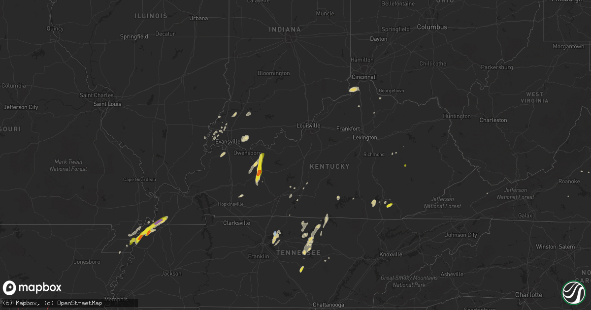
Hail Map in Kentucky on May 2, 2019
Get this storm
May 2 map
$229
one time, instant access
Download today. No call, no setup
Keep the $229
Bought the map and want the full workflow? Apply the entire $229 to a subscription within 7 days. None of it is wasted.
Every map, not just this one
This buys you this map. Subscription and you get every map we run, in the markets you choose from a few cities to whole states to nationwide. Plus real-time alerts the moment a storm fires.
Contact data
Name, contact info, occupancy, even credit band for addresses in the footprint. You go from where it hit to who to call.
Become the source they trust
Unlimited branding weather history reports on demand. You already have the documented answer ready for the property owner, and you are the one who showed up with it.
Property data and RoofTrace estimates
Pull up any address you have got, its value and the exact code rules for that jurisdiction, straight from One Click Code. Then RoofTrace estimates the squares, pitch, and roof value, priced the way you price.
Storm reports in Kentucky
Kentucky
| Date | Description |
|---|---|
| 05/02/20196:57 PM CDT | Tree limbs down near intersection of main and 1st street. Nickel size hail also observed. |
| 05/02/20194:54 PM CDT | Tree down on wolverine road. |
| 05/02/20194:09 PM CDT | A tree was blown down on oak grove school road. |
| 05/02/20191:13 PM CDT | One tree downed. |
| 05/02/20193:00 AM CDT | At 759 PM CDT, a severe thunderstorm was located near Cayce, or near Clinton, moving northeast at 20 mph. HAZARD...Ping pong ball size hail and 60 mph wind gusts. SOURCE...Radar indicated. IMPACT...People and animals outdoors will be injured. Expect hail damage to roofs, siding, windows, and vehicles. Expect wind damage to roofs, siding, and trees. Locations impacted include... Fulton, Cayce and Fulgham. |
| 05/02/20191:46 AM CDT | At 646 PM CDT, a severe thunderstorm was located near Hartford, moving north at 25 mph. HAZARD...60 mph wind gusts and quarter size hail. SOURCE...Radar indicated. IMPACT...Hail damage to vehicles is expected. Expect wind damage to roofs, siding, and trees. Locations impacted include... Hartford, Beaver Dam, Mchenry, Taffy, Ralph, Magan, Jingo, Pleasant Ridge, Sulphur Springs and Adaburg. |
| 05/02/201912:39 AM CDT | At 538 PM EDT, a severe thunderstorm was located over Swan Lake, or near Barbourville, moving east at 15 mph. HAZARD...60 mph wind gusts and quarter size hail. SOURCE...Radar indicated. IMPACT...Hail damage to vehicles is expected. Expect wind damage to roofs, siding, and trees. Locations impacted include... Barbourville, Pineville, Artemus, Swan Lake, Clate, Birdseye, Barnyard, Salt Gum, King, Jarvis, Blanche and Girdler. |
| 05/02/201912:38 AM CDT | At 538 PM EDT, a severe thunderstorm was located over Athol, or 8 miles northeast of Booneville, moving east at 15 mph. HAZARD...60 mph wind gusts and quarter size hail. SOURCE...Radar indicated. IMPACT...Hail damage to vehicles is expected. Expect wind damage to roofs, siding, and trees. Locations impacted include... Jackson, Canyon Falls, Keck, Oakdale, Copebranch, Noctor, Athol, Frozen Creek, Quicksand, War Creek, Gentry and Elkatawa. |
| 05/01/201911:49 PM CDT | At 448 PM EDT, a severe thunderstorm was located over Bark Camp, or 14 miles northwest of Williamsburg, moving northeast at 15 mph. HAZARD...60 mph wind gusts and quarter size hail. SOURCE...Radar indicated. IMPACT...Hail damage to vehicles is expected. Expect wind damage to roofs, siding, and trees. Locations impacted include... London, Fariston, Pittsburg, Garrich, Moore Hill, Lily, Rossland, Deering, North Corbin, Jarvis, Cranes Nest and Hightop. |
| 05/01/20199:58 PM CDT | At 258 PM EDT, a severe thunderstorm was located over Brooksville, moving east at 15 mph. HAZARD...60 mph wind gusts and quarter size hail. SOURCE...Radar indicated. IMPACT...Minor hail damage to vehicles is possible. Expect wind damage to trees and power lines. Locations impacted include... Maysville, Ripley, Aberdeen, Augusta, Brooksville, Russellville, Dover, Higginsport, Germantown, Minerva, Redoak, Woolcutt, Moranburg, Parina, South Ripley, Chatham, Tuckahoe, Stoney Point and Aa Highway at State Route 19. |
| 05/01/20199:22 PM CDT | At 222 PM CDT, a severe thunderstorm was located 9 miles west of Byrdstown, moving northeast at 25 mph. HAZARD...60 mph wind gusts and penny size hail. SOURCE...Radar indicated. IMPACT...Expect damage to roofs, siding, and trees. This severe thunderstorm will remain over mainly rural areas of northwestern Pickett and northeastern Clay Counties. |
| 05/01/20199:12 PM CDT | At 211 PM EDT, a severe thunderstorm was located near Claryville, moving east at 30 mph. HAZARD...60 mph wind gusts and quarter size hail. SOURCE...Radar indicated. IMPACT...Minor hail damage to vehicles is possible. Expect wind damage to trees and power lines. Locations impacted include... Independence, Alexandria, Claryville, New Richmond, Ryland Heights, Mentor, California, Visalia, Atwood, Grants Lick, Aspen Grove, Morning View, Gubser Mill, Peach Grove, White Villa, Ivor, Campbell County Lake, Fiskburg, Piner and White Tower. |
| 05/01/20198:26 PM CDT | At 126 PM CDT, a severe thunderstorm was located over Red Boiling Springs, or 10 miles east of Lafayette, moving northeast at 15 mph. HAZARD...60 mph wind gusts and penny size hail. SOURCE...Radar indicated. IMPACT...Expect damage to roofs, siding, and trees. Locations impacted include... Red Boiling Springs. |
| 05/01/20197:46 PM CDT | Tree limbs down near zion church road and old leitchfield road. Time estimated by radar. |
| 05/01/20197:05 PM CDT | Fell along the natcher parkway. |
All States Impacted by Hail Map on May 2, 2019
Cities Impacted by Hail Map on May 2, 2019
- Murfreesboro, TN
- Pollok, TX
- Baird, TX
- Union, KY
- Verona, KY
- Warsaw, KY
- Walton, KY
- Patriot, IN
- Cisco, TX
- Comstock, TX
- Del Rio, TX
- Valley Mills, TX
- Bloomington Springs, TN
- Smiths Grove, KY
- Park City, KY
- Boonville, IN
- Tennyson, IN
- Chrisney, IN
- Ridgely, TN
- Lebanon, TN
- Mount Juliet, TN
- Eastland, TX
- Fort Stockton, TX
- Hartford, KY
- Beaver Dam, KY
- Eden, TX
- Dryden, TX
- Carbon, TX
- Anson, TX
- Milano, TX
- Dickerson, MD
- Germantown, MD
- Poolesville, MD
- Great Falls, VA
- Leesburg, VA
- Potomac, MD
- Ashburn, VA
- Sterling, VA
- Barbourville, KY
- Rockholds, KY
- Wadesville, IN
- May, TX
- Sidney, TX
- Cynthiana, KY
- Cleburne, TX
- New Harmony, IN
- Poseyville, IN
- Richland, IN
- Buffalo Valley, TN
- Silver Point, TN
- Baxter, TN
- Coleman, TX
- Winters, TX
- Talpa, TX
- Valera, TX
- Ballinger, TX
- Russell Springs, KY
- Jamestown, KY
- Carlton, TX
- Dublin, TX
- Ordway, CO
- Brackettville, TX
- Troy, TN
- Whitesville, KY
- Utica, KY
- Fredericksburg, TX
- Morgantown, KY
- Brownsville, KY
- Iraan, TX
- Sheffield, TX
- Big Wells, TX
- Huntsville, TX
- Cameron, TX
- Comanche, TX
- Blanket, TX
- Hornbeak, TN
- De Leon, TX
- Smithville, TN
- Laredo, TX
- Mirando City, TX
- Gatesville, TX
- Lawn, TX
- Goldsboro, TX
- Lynchburg, VA
- Madison Heights, VA
- Abilene, TX
- Parkers Lake, KY
- Corbin, KY
- Bedias, TX
- Beattyville, KY
- Jackson, KY
- Gallatin, TN
- Christoval, TX
- Eldorado, TX
- Rising Star, TX
- Gainesboro, TN
- Owensville, IN
- Philpot, KY
- Rochester, KY
- Drakesboro, KY
- Livermore, KY
- Fordsville, KY
- Hawesville, KY
- Reynolds Station, KY
- Olaton, KY
- Centertown, KY
- Celina, TN
- Allons, TN
- Burkesville, KY
- Elkton, KY
- Cave City, KY
- Corydon, KY
- Henderson, KY
- Hickman, KY
- Rocky Mount, VA
- Santa Anna, TX
- Boone, CO
- Olney Springs, CO
- Princeton, IN
- Fort Branch, IN
- Scottsville, KY
- Adolphus, KY
- Blackwell, TX
- Weinert, TX
- Elmwood, TN
- Gordonsville, VA
- Goldthwaite, TX
- Hillsboro, TX
- Whitney, TX
- Riesel, TX
- Waco, TX
- Timpson, TX
- Hearne, TX
- Ovalo, TX
- Glen Rose, TX
- Bryan, TX
- Crawford, TX
- Hendersonville, TN
- Sonora, TX
- Natchitoches, LA
- Oilton, TX
- San Ygnacio, TX
- Bruni, TX
- Zapata, TX
- Hebbronville, TX
- Aldie, VA
- Middleburg, VA
- The Plains, VA
- Junction, TX
- Moran, TX
- Clyde, TX
- Albany, TX
- Mount Vernon, IN
- Cross Plains, TX
- Iola, TX
- Mcminnville, TN
- Morrison, TN
- Red Boiling Springs, TN
- Whitleyville, TN
- Pleasant Shade, TN
- Lafayette, TN
- Gorman, TX
- Menard, TX
- Fulton, KY
- Wingo, KY
- Hayti, MO
- Tiptonville, TN
- Clinton, KY
- Caruthersville, MO
- Union City, TN
- Stephenville, TX
- Stanton, KY
- Rockdale, TX
- Hardyville, KY
- Horse Cave, KY
- Brady, TX
- Comfort, TX
- Kerrville, TX
- San Saba, TX
- McGregor, TX
- London, TX
- Mason, TX
- Hico, TX
- Malone, TX
- Calvert, TX
- Sylvester, TX
- Francisco, IN
- Petersburg, IN
- Otwell, IN
- Velpen, IN
- Jasper, IN
- Winslow, IN
- Nolan, TX
- Walnut Springs, TX
- Iredell, TX
- Meridian, TX
- Lexington, TX
- Frenchburg, KY
- Haubstadt, IN
- Cotulla, TX
- Nacogdoches, TX
- Lancaster, TN
- Granville, TN
- Dowelltown, TN
- Hilham, TN
- Buffalo, TX
- Temple Hills, MD
- Merkel, TX
- Hawley, TX
- Gray, KY
- Cookeville, TN
- Novice, TX
- Voss, TX
- Davidsonville, MD
- Annapolis, MD
- Crownsville, MD
- Gambrills, MD
- Bedford, VA
- Montvale, VA
- Clifton, TX
- Sweetwater, TX
- Trent, TX
- Steele, MO
- Harper, TX
- Cushing, TX
- Concord, VA
- Glasgow, KY
- Garrison, TX
- Vancourt, TX
- Portageville, MO
- Ranger, TX
- College Station, TX
- Woodbine, KY
- Evansville, IN
- Cynthiana, IN
- Laughlin Afb, TX
- Cedar Bluff, VA
- Sparta, TN
- Melvin, TX
- Marquez, TX
- Williamstown, KY
- Carmi, IL
- Hopkinsville, KY
- Monticello, KY
- Brownwood, TX
- Blytheville, AR
- Rochelle, TX
- Richland Springs, TX
- Oglesby, TX
- Haskell, TX
- Carthage, TN
- Ravenna, KY
- Clay City, KY
- Evant, TX
- Purmela, TX
- Washington, DC
- Burtonsville, MD
- Laurel, MD
- Gause, TX
- Thrall, TX
- Elgin, TX
- Foster, KY
- Brooksville, KY
- Patoka, IN
- Mount Carmel, IL
- Desdemona, TX
- Horse Branch, KY
- Little Rock, AR
- Mabelvale, AR
- Sherwood, AR
- Jacksonville, AR
- Cabot, AR
- Des Arc, AR
- Dillwyn, VA
- New Canton, VA
- Arvonia, VA
- Kensington, MD
- Herndon, VA
- Gaithersburg, MD
- Rockville, MD
- Reston, VA
- Bethesda, MD


