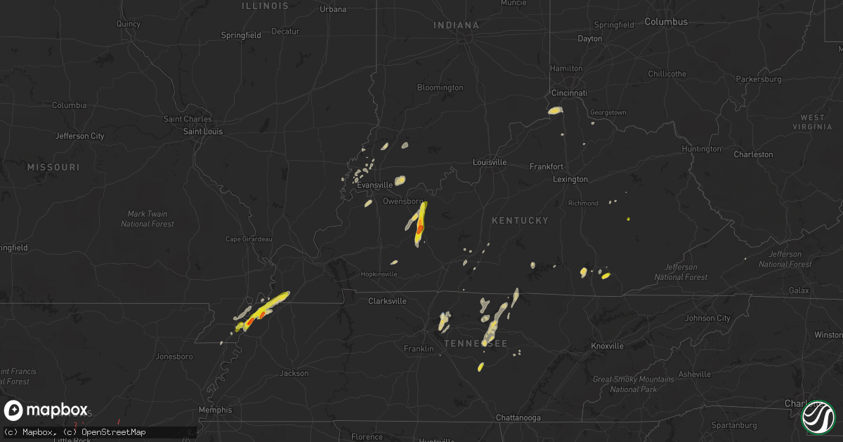
Hail Map on May 2, 2019
Get this storm
May 2 map
$229
one time, instant access
Download today. No call, no setup
Keep the $229
Bought the map and want the full workflow? Apply the entire $229 to a subscription within 7 days. None of it is wasted.
Every map, not just this one
This buys you this map. Subscription and you get every map we run, in the markets you choose from a few cities to whole states to nationwide. Plus real-time alerts the moment a storm fires.
Contact data
Name, contact info, occupancy, even credit band for addresses in the footprint. You go from where it hit to who to call.
Become the source they trust
Unlimited branding weather history reports on demand. You already have the documented answer ready for the property owner, and you are the one who showed up with it.
Property data and RoofTrace estimates
Pull up any address you have got, its value and the exact code rules for that jurisdiction, straight from One Click Code. Then RoofTrace estimates the squares, pitch, and roof value, priced the way you price.
States Impacted by Hail Map on May 2, 2019
Storm reports
West Virginia
| Date | Description |
|---|---|
| 05/02/20195:15 PM CDT | Dozens of trees down in the big bend/tornado area of kanawha county |
| 05/02/20195:08 PM CDT | Nws survey team determined a microburst occurred at the big bend golf course. Estimated wind speeds of 65 to 75 mph. Numerous pine trees blown down. Minor structural da |
| 05/02/20193:22 AM CDT | At 822 PM EDT, a severe thunderstorm was located over Amherstdale-Robinette, or 13 miles east of Logan, moving northeast at 25 mph. HAZARD...60 mph wind gusts and quarter size hail. SOURCE...Radar indicated. IMPACT...Hail damage to vehicles is expected. Expect wind damage to roofs, siding, and trees. Locations impacted include... Man, Van, Mallory, Amherstdale-Robinette, Wharton, Bald Knob, Whitesville, Sylvester, Cyclone, Naoma, Prenter, Stickney, Amherstdale-Robine and Blair. |
District of Columbia
| Date | Description |
|---|---|
| 05/01/201910:38 PM CDT | At 337 PM EDT, severe thunderstorms were located along a line extending from Mclean to Fairfax, moving east at 20 mph. HAZARD...60 mph wind gusts. SOURCE...Radar indicated. IMPACT...Damaging winds will cause some trees and large branches to fall. This could injure those outdoors, as well as damage homes and vehicles. Roadways may become blocked by downed trees. Localized power outages are possible. Unsecured light objects may become projectiles. Locations impacted include... Arlington, Alexandria, Centreville, Bethesda, Bowie, Annandale, Clinton, Springfield, Fort Washington, Fairfax, Fort Hunt, Vienna, Groveton, Forestville, Falls Church, Huntington, Largo, Coral Hills, Mantua and Fort Belvoir. |
| 05/01/201910:30 PM CDT | At 329 PM EDT, severe thunderstorms were located along a line extending from near Olney to near Potomac, moving east at 25 mph. HAZARD...60 mph wind gusts and quarter size hail. SOURCE...Radar indicated. IMPACT...Damaging winds will cause some trees and large branches to fall. This could injure those outdoors, as well as damage homes and vehicles. Roadways may become blocked by downed trees. Localized power outages are possible. Unsecured light objects may become projectiles. Locations impacted include... Columbia, Rockville, Bethesda, Gaithersburg, Olney, College Park, Greenbelt, Langley Park, Beltsville, Bladensburg, University of Maryland, Fort Totten, Ellicott City, Aspen Hill, Potomac, North Bethesda, Montgomery Village, Laurel, North Potomac and Fairland. |
Louisiana
| Date | Description |
|---|---|
| 05/02/20197:08 AM CDT | The tornado briefly touched down near the intersection of us hwy 84... Oak hill rd... And kings hwy... Snapping numerous trees and damaging or destroying several small |
| 05/02/20193:03 AM CDT | At 802 AM CDT, a severe thunderstorm was located over Slagle, moving east at 25 mph. HAZARD...60 mph wind gusts and penny size hail. SOURCE...Radar indicated. IMPACT...Expect damage to roofs, siding, and trees. Locations impacted include... Slagle, Clifton, Lacamp, Leander, Sieper and Simpson. |
| 05/02/201912:41 AM CDT | At 540 AM CDT, a severe thunderstorm was located near Carthage, moving northeast at 30 mph. HAZARD...60 mph wind gusts. SOURCE...Radar indicated. IMPACT...Expect damage to roofs, siding, and trees. Locations impacted include... Shreveport, Carthage, Greenwood, Waskom, Stonewall, Tenaha, Beckville, Deberry, Elysian Fields, Gary City, Keachi, Longstreet, Keat Chie, Front, Spring Ridge, Cross Lake, Jonesville, Midyett, Kickapoo and Keithville. |
Maryland
| Date | Description |
|---|---|
| 05/02/20193:48 PM CDT | Tree reported down on outbound lane of pennsylvania ave near suitland parkway. |
| 05/02/20193:35 PM CDT | Multiple trees uprooted on property. |
| 05/02/20193:30 PM CDT | Large tree down on the 2800 block of haven rd |
| 05/02/20193:19 PM CDT | Tree reported down on outbound lane of pennsylvania ave near suitland parkway. |
| 05/02/20193:07 PM CDT | Tree down on westbard ave near massachusetts ave. |
| 05/02/20192:43 PM CDT | Tree down on westbard ave near massachusetts ave. |
| 05/02/20192:35 PM CDT | Tree reported down on wootton parkway just east of pasture brooke way. |
| 05/02/20192:29 PM CDT | Multiple trees down in the vicinity of gainsboro road |
| 05/02/20192:24 PM CDT | Tree down on wires at falls road and oaklyn drive |
| 05/02/20192:22 PM CDT | Pine tree uprooted at falls road and cold spring road |
| 05/02/20191:35 AM CDT | At 635 PM EDT, severe thunderstorms were located along a line extending from near Breezy Point to Sheridan Point to 6 miles south of Golden Beach, moving east at 35 mph. HAZARD...60 mph wind gusts. SOURCE...Radar indicated. IMPACT...Damaging winds will cause some trees and large branches to fall. This could injure those outdoors, as well as damage homes and vehicles. Roadways may become blocked by downed trees. Localized power outages are possible. Unsecured light objects may become projectiles. Locations impacted include... Lexington Park, Chesapeake Ranch Estates, Prince Frederick, Sheridan Point, Saint Leonard Creek, Town Creek, Flag Harbor, Calvert Cliffs, Greenwell State Park, California, Golden Beach, Lusby, Patuxent River Naval Air Station, Saint Leonard, Hollywood, Huntingtown, Drum Point, Long Beach, Mechanicsville and Calvert Beach. |
| 05/01/201911:48 PM CDT | At 447 PM EDT, a severe thunderstorm was located near Severn River, moving east at 35 mph. HAZARD...60 mph wind gusts and quarter size hail. SOURCE...Radar indicated. IMPACT...Minor damage to vehicles is possible. Wind damage to roofs, siding, trees, and power lines is possible. Locations impacted include... Easton, Centerville, Centreville, Romancoke, Queen Anne, Tanyard, Grasonville, Starr, Stevensville, Skipton, Copperville, Jumptown, Chester, Matthews, Overton, Wye Mills, Cordova, Carville, Hope and Queenstown. |
| 05/01/201911:39 PM CDT | At 439 PM EDT, severe thunderstorms were located along a line extending from Fort Smallwood State Park to South River, moving east at 25 mph. HAZARD...60 mph wind gusts. SOURCE...Radar indicated. IMPACT...Damaging winds will cause some trees and large branches to fall. This could injure those outdoors, as well as damage homes and vehicles. Roadways may become blocked by downed trees. Localized power outages are possible. Unsecured light objects may become projectiles. Locations impacted include... Annapolis, Riviera Beach, Mayo, Naval Academy, Severn River, South River, Fort Smallwood State Park, Pinehurst, Gibson Island, Bodkin Point, Sillery Bay, Severna Park, Pasadena, Arnold, Lake Shore, Parole, Green Haven, Londontowne, Edgewater and Cape St. Claire. |
| 05/01/201910:54 PM CDT | At 353 PM EDT, severe thunderstorms were located along a line extending from Columbia to Hyattsville, moving east at 35 mph. HAZARD...60 mph wind gusts. SOURCE...Radar indicated. IMPACT...Damaging winds will cause some trees and large branches to fall. This could injure those outdoors, as well as damage homes and vehicles. Roadways may become blocked by downed trees. Localized power outages are possible. Unsecured light objects may become projectiles. Locations impacted include... Columbia, Bowie, Severn, Annapolis, College Park, Crofton, Greenbelt, Beltsville, Elkridge, Riviera Beach, Bladensburg, Mayo, Naval Academy, Baltimore-Washington Airport, Severn River, South River, Fort Smallwood State Park, Bodkin Point, Sillery Bay and Rhode River. |
| 05/01/201910:03 PM CDT | At 303 PM EDT, severe thunderstorms were located along a line extending from near Poolesville to near Middleburg, moving east at 25 mph. HAZARD...60 mph wind gusts and quarter size hail. SOURCE...Radar indicated. IMPACT...Damaging winds will cause some trees and large branches to fall. This could injure those outdoors, as well as damage homes and vehicles. Roadways may become blocked by downed trees. Localized power outages are possible. Unsecured light objects may become projectiles. Locations impacted include... Germantown, Centreville, Rockville, Bethesda, Gaithersburg, Reston, Leesburg, Olney, South Riding, Herndon, Broadlands, Lansdowne, Lowes Island, Brambleton, Poolesville, Dulles International Airport, Aspen Hill, Potomac, North Bethesda and Ashburn. |
Colorado
| Date | Description |
|---|---|
| 05/02/20193:13 AM CDT | At 813 PM MDT, a severe thunderstorm was located 15 miles southwest of Forder, or 38 miles northwest of La Junta, moving east at 30 mph. HAZARD...60 mph wind gusts and quarter size hail. SOURCE...Radar indicated. IMPACT...Hail damage to vehicles is expected. Expect wind damage to roofs, siding, and trees. This severe thunderstorm will remain over mainly rural areas of northeastern Crowley County. |
Indiana
| Date | Description |
|---|---|
| 05/02/20192:45 AM CDT | At 745 PM CDT, a severe thunderstorm was located near Whitesville, moving north at 20 mph. HAZARD...60 mph wind gusts and half dollar size hail. SOURCE...Radar indicated. IMPACT...Hail damage to vehicles is expected. Expect wind damage to roofs, siding, and trees. Locations impacted include... Hawesville, Cannelton, Fordsville, Petri, Skillman, Goering, Pellville, Deanefield, Floral and Patesville. |
| 05/01/20198:41 PM CDT | At 141 PM EDT, a severe thunderstorm was located near Patriot, moving east at 20 mph. HAZARD...60 mph wind gusts and quarter size hail. SOURCE...Radar indicated. IMPACT...Minor hail damage to vehicles is possible. Expect wind damage to trees and power lines. Locations impacted include... Florence, Independence, Erlanger, Edgewood, Elsmere, Crescent Springs, Walton, Crestview Hills, Rising Sun, Oakbrook, Burlington, Union, Crittenden, Patriot, Richwood, Ryle, Big Bone Lick, Waterloo, Steele Bottom and Bracht.This includes the following Interstates... I-71 in Kentucky between mile markers 66 and 77. I-75 in Kentucky between mile markers 166 and 185. |
Tennessee
| Date | Description |
|---|---|
| 05/02/20196:50 PM CDT | Quarter size hail reported east of tiptonville near the frierson rd and hwy 22 intersection. |
| 05/02/20196:43 PM CDT | Brief tornado caused tree damage along highway 21. |
| 05/02/20196:43 PM CDT | Large tree branches down along highway 21. |
| 05/02/20196:40 PM CDT | Pole down on highway 78. |
| 05/02/20196:21 PM CDT | Ef-0 tornado caused tree damage along bluff road. |
| 05/02/20196:20 PM CDT | Large branches down near the intersection of south bluff road and bud barker road. |
| 05/02/20196:19 PM CDT | Tornado reported east of caruthersville. |
| 05/02/20196:10 PM CDT | Golf ball size hail reported in ridgely. |
| 05/02/20194:18 PM CDT | Shingles blown off of roof and heavy outdoor furniture displaced. Time estimated by radar. |
| 05/02/20194:07 PM CDT | Tree down near centertown. |
| 05/02/20193:40 PM CDT | Large tree uprooted and power pole snapped. Time estimated from radar. |
| 05/02/20197:03 AM CDT | At 1203 PM CDT, a severe thunderstorm was located 11 miles south of Nolensville, or 14 miles west of Murfreesboro, moving north at 20 mph. HAZARD...60 mph wind gusts and quarter size hail. SOURCE...Radar indicated. IMPACT...Hail damage to vehicles is expected. Expect wind damage to roofs, siding, and trees. Locations impacted include... Murfreesboro, Smyrna, La Vergne, Nolensville, Walterhill, Eagleville, Rockvale and Triune.This includes the following highways... Interstate 24 between mile markers 64 and 80. Interstate 840 between mile markers 41 and 65. |
| 05/02/20192:43 AM CDT | At 741 PM CDT, a severe thunderstorm was located 5 miles southeast of Hickman, moving northeast at 15 mph. HAZARD...60 mph wind gusts and quarter size hail. SOURCE...Radar indicated. IMPACT...Hail damage to vehicles is expected. Expect wind damage to roofs, siding, and trees. Locations impacted include... Cayce. |
| 05/02/20191:15 AM CDT | At 615 PM CDT, a severe thunderstorm was located over Caruthersville, moving northeast at 25 mph. HAZARD...60 mph wind gusts and quarter size hail. SOURCE...Radar indicated. IMPACT...Hail damage to vehicles is expected. Expect wind damage to roofs, siding, and trees. Locations impacted include... Caruthersville, Portageville, Hayti, Hayti Heights, Hathaway, Stanley, Stubtown, Canady and Hayward. |
| 05/02/20191:02 AM CDT | At 602 PM CDT, a severe thunderstorm was located over Cottonwood Grove, or near Caruthersville, moving north at 20 mph. HAZARD...Ping pong ball size hail and 60 mph wind gusts. SOURCE...Radar indicated. IMPACT...People and animals outdoors will be injured. Expect hail damage to roofs, siding, windows, and vehicles. Expect wind damage to roofs, siding, and trees. Locations impacted include... Caruthersville, Reelfoot Lake State Park, Tiptonville, Ridgely, Miston, Cottonwood Grove, Samburg, Wynnburg, Cronanville, Hathaway, Sunkist Beach, Blue Bank, Proctor City, Broadmoor, Madie, Mooring, Haynes, Tennemo, Lassiter Corner and Gratio. |
| 05/02/201912:26 AM CDT | At 526 PM CDT, a severe thunderstorm was located over Steele, moving northeast at 25 mph. HAZARD...60 mph wind gusts and half dollar size hail. SOURCE...Radar indicated. IMPACT...Hail damage to vehicles is expected. Expect wind damage to roofs, siding, and trees. Locations impacted include... Caruthersville, Hayti, Steele, Hayti Heights, Cooter, Deering, Bolton, Holland, Bragg City, Pascola, Hathaway, Mooring, Homestown, West Hermondale, New Survey, Denton, Covington, Shade, Bakerville and Canady. |
| 05/01/201911:42 PM CDT | At 442 PM CDT, a severe thunderstorm was located near Baxter, or 12 miles north of Smithville, moving north at 30 mph. HAZARD...60 mph wind gusts and penny size hail. SOURCE...Radar indicated. IMPACT...Expect damage to roofs, siding, and trees. Locations impacted include... Gainesboro, Baxter, Center Hill Lake, Granville and Edgar Evans State Park.This includes Interstate 40 between mile markers 262 and 280. |
| 05/01/201911:18 PM CDT | At 418 PM CDT, a severe thunderstorm was located near Gallatin, moving north at 20 mph. HAZARD...60 mph wind gusts and penny size hail. SOURCE...Radar indicated. IMPACT...Expect damage to roofs, siding, and trees. Locations impacted include... Gallatin, Lebanon, Bledsoe Creek State Park, Cottontown and Dickerson Chapel Recreation Area. |
| 05/01/201911:16 PM CDT | At 416 PM CDT, a severe thunderstorm was located over Smithville, moving north at 20 mph. HAZARD...60 mph wind gusts and nickel size hail. SOURCE...Radar indicated. IMPACT...Expect damage to roofs, siding, and trees. Locations impacted include... Smithville, Baxter, Dowelltown, Center Hill Lake and Edgar Evans State Park.This includes Interstate 40 between mile markers 261 and 281. |
| 05/01/201911:04 PM CDT | At 403 PM CDT, a severe thunderstorm was located over Mount Juliet, or 10 miles west of Lebanon, moving northeast at 30 mph. HAZARD...60 mph wind gusts and penny size hail. SOURCE...Radar indicated. IMPACT...Expect damage to roofs, siding, and trees. Locations impacted include... Gallatin, Lebanon, Hendersonville, Mount Juliet and Belinda City. |
| 05/01/201910:59 PM CDT | At 359 PM CDT, severe thunderstorms were located along a line extending from 7 miles northwest of Manchester to near McMinnville, moving northeast at 30 mph. HAZARD...60 mph wind gusts and penny size hail. SOURCE...Radar indicated. IMPACT...Expect damage to roofs, siding, and trees. Locations impacted include... McMinnville, Morrison, Centertown, Bradyville and Summitville. This includes Interstate 24 between mile markers 102 and 110. |
| 05/01/20199:44 PM CDT | At 243 PM CDT, a severe thunderstorm was located 8 miles southwest of Baxter, or 8 miles northeast of Smithville, moving northeast at 25 mph. HAZARD...60 mph wind gusts and penny size hail. SOURCE...Radar indicated. IMPACT...Expect damage to roofs, siding, and trees. Locations impacted include... Cookeville, Algood, Baxter, Center Hill Lake, Edgar Evans State Park and Cummins Falls State Park.This includes Interstate 40 between mile markers 268 and 290. |
| 05/01/20199:38 PM CDT | At 237 PM CDT, a severe thunderstorm was located near Gainesboro, moving northeast at 25 mph. Other strong to severe thunderstorms were also covering the area. HAZARD...60 mph wind gusts and penny size hail. SOURCE...Radar indicated. IMPACT...Expect damage to roofs, siding, and trees. Locations impacted include... Livingston, Gainesboro, Whitleyville and Standing Stone State Park. |
| 05/01/20199:14 PM CDT | At 214 PM CDT, a severe thunderstorm was located 7 miles southwest of Gainesboro, moving northeast at 25 mph. HAZARD...60 mph wind gusts and penny size hail. SOURCE...Radar indicated. IMPACT...Expect damage to roofs, siding, and trees. Locations impacted include... Gainesboro and Whitleyville. |
Delaware
| Date | Description |
|---|---|
| 05/02/20195:43 PM CDT | Two trees down on scotts store rd. Time estimated from radar. |
| 05/02/20191:38 AM CDT | At 638 PM EDT, a severe thunderstorm was located over Andrewsville, or 15 miles northwest of Georgetown, moving east at 15 mph. HAZARD...60 mph wind gusts and quarter size hail. SOURCE...Radar indicated. IMPACT...Minor damage to vehicles is possible. Wind damage to roofs, siding, trees, and power lines is possible. Locations impacted include... Georgetown, Milford, Milton, Bridgeville, Ellendale, Andrewsville, Greenwood and Farmington. |
Ohio
| Date | Description |
|---|---|
| 05/02/20193:54 PM CDT | One tree was knocked down on old gallia pike road. |
Texas
| Date | Description |
|---|---|
| 05/02/20195:57 PM CDT | A local report indicates 1.75 inch wind near SHEFFIELD |
| 05/02/20195:20 PM CDT | A local report indicates 1.50 inch wind near SHEFFIELD |
| 05/02/20195:17 PM CDT | A local report indicates 1.00 inch wind near 1 E SHEFFIELD |
| 05/02/20191:42 PM CDT | Quarter size hail reported in de leon |
| 05/02/20191:35 PM CDT | A local report indicates 1.00 inch wind near 3 NW BLANKET |
| 05/02/20191:22 PM CDT | Hams report via phone call. Quarter size hail reported on hwy 6 between gorman and de leon |
| 05/02/201912:20 PM CDT | Late report: hail between the the size of quarters and golf balls reported along highway 60 between pampa and miami. Time estimated by radar |
| 05/02/20197:58 AM CDT | At 1258 AM CDT, a severe thunderstorm was located 4 miles south of Kingsmill, or 9 miles southwest of Pampa, moving east at 20 mph. HAZARD...Ping pong ball size hail and 60 mph wind gusts. SOURCE...Radar indicated. IMPACT...Minor damage to roofs, siding, and trees is possible. People and animals outdoors will be injured. Expect hail damage to roofs, siding, windows, and vehicles. Locations impacted include... Pampa, Lefors and Kingsmill. |
| 05/02/20197:52 AM CDT | At 1251 PM CDT, a severe thunderstorm was located 13 miles southwest of Sonora, moving northeast at 5 mph. HAZARD...Ping pong ball size hail and 60 mph wind gusts. SOURCE...Radar indicated. IMPACT...People and animals outdoors will be injured. Expect hail damage to roofs, siding, windows, and vehicles. Expect wind damage to roofs, siding, and trees. This severe thunderstorm will remain over mainly rural areas of western Sutton County, including the following locations... The Intersection Of Us-277 And Ranch Road 189.This includes Interstate 10 between Mile Markers 395 and 403. |
| 05/02/20197:44 AM CDT | At 1244 AM CDT, a severe thunderstorm was located 9 miles northeast of Lefors, or 12 miles south of Miami, moving southeast at 25 mph. HAZARD...60 mph wind gusts and half dollar size hail. SOURCE...Radar indicated. IMPACT...Minor damage to roofs, siding, and trees is possible. Hail damage to vehicles is expected. Locations impacted include... Briscoe, Lefors, New Mobeetie, Kellerville and Mobeetie. |
| 05/02/20197:36 AM CDT | At 1236 PM CDT, a severe thunderstorm was located 8 miles north of Rising Star, or 12 miles south of Cisco, moving southeast at 40 mph. HAZARD...60 mph wind gusts and quarter size hail. SOURCE...Radar indicated. IMPACT...Hail damage to vehicles is expected. Expect wind damage to roofs, siding, and trees. Locations impacted include... Eastland, De Leon, Gorman, Rising Star and Carbon. This includes Interstate 20 between mile markers 336 and 342. |
| 05/02/20197:27 AM CDT | At 1227 AM CDT, a severe thunderstorm was located 5 miles northwest of White Deer, or 12 miles northeast of Panhandle, moving east at 20 mph. HAZARD...60 mph wind gusts and half dollar size hail. SOURCE...Radar indicated. IMPACT...Minor damage to roofs, siding, and trees is possible. Hail damage to vehicles is expected. Locations impacted include... Pampa, White Deer, Skellytown and Kingsmill. |
| 05/02/20197:05 AM CDT | At 1205 AM CDT, a severe thunderstorm was located near Codman, or 9 miles west of Miami, moving east at 20 mph. HAZARD...60 mph wind gusts and quarter size hail. SOURCE...Radar indicated. IMPACT...Minor damage to roofs, siding, and trees is possible. Hail damage to vehicles is expected. Locations impacted include... Miami, Codman and Lora. |
| 05/02/20196:45 AM CDT | Light pole blown down on highway 359 in oilton. |
| 05/02/20196:29 AM CDT | At 1129 PM CDT, a severe thunderstorm was located near Langtry, moving east at 15 mph. HAZARD...Quarter size hail. SOURCE...Radar indicated. IMPACT...Damage to vehicles is expected. Locations impacted include... Langtry, Shumla, Osman, Seminole Canyon State Park and Amistad Recreation Area - Pecos River Boat Ramp. |
| 05/02/20195:56 AM CDT | At 1056 PM CDT, a severe thunderstorm was located near Lake View, or near Del Rio, moving southeast at 25 mph. HAZARD...Golf ball size hail and 60 mph wind gusts. SOURCE...Radar indicated. IMPACT...People and animals outdoors will be injured. Expect hail damage to roofs, siding, windows, and vehicles. Expect wind damage to roofs, siding, and trees. Locations impacted include... Del Rio, Lake View, Amistad Village, Amistad Recreation Area - Governors Landing, Amistad Recreation Area - Diablo East, Amistad Recreation Area - Black Brush Point, Amanda, Laughlin AFB, Amistad Recreation Area - Long Point, Val Verde Park, Standart, Cienegas Terrace, Amistad Recreation Area - San Pedro Canyon, Amistad Recreation Area - 277 North Campground and Amistad Recreation Area - 277 South Boat Ramp. |
| 05/02/20194:58 AM CDT | At 957 PM CDT, a severe thunderstorm was located 9 miles east of Comstock, moving southeast at 25 mph. This is a very dangerous storm. HAZARD...Baseball size hail and 70 mph wind gusts. SOURCE...Radar indicated. IMPACT...People and animals outdoors will be severely injured. Expect shattered windows, extensive damage to roofs, siding, and vehicles. Locations impacted include... Del Rio, Lake View, Amistad Village, Amistad Recreation Area - Governors Landing, Amistad Recreation Area - Diablo East, Amistad Recreation Area - Black Brush Point, Amistad Acres, Laughlin AFB, Box Canyon, Amistad Recreation Area - Long Point, Val Verde Park, Cienegas Terrace, Devils Shores, Pafford Crossing, Amistad Recreation Area - Rock Quarry Campground, Devils River SNA - Big Satan, Amistad Recreation Area - San Pedro Canyon, Amistad Recreation Area - Rough Canyon, Amistad Recreation Area - Spur 406 Campground and Salem Point. |
| 05/02/20194:34 AM CDT | At 934 PM CDT, a severe thunderstorm was located 8 miles northeast of Comstock, moving southeast at 15 mph. HAZARD...Golf ball size hail and 70 mph wind gusts. SOURCE...Radar indicated. IMPACT...People and animals outdoors will be injured. Expect hail damage to roofs, siding, windows, and vehicles. Expect considerable tree damage. Wind damage is also likely to mobile homes, roofs, and outbuildings. Locations impacted include... Del Rio, Comstock, Lake View, Amistad Village, Amistad Recreation Area - Governors Landing, Amistad Recreation Area - Diablo East, Amistad Recreation Area - Black Brush Point, Amistad Acres, Seminole Canyon State Park, Laughlin AFB, Box Canyon, Amistad Recreation Area - Long Point, Val Verde Park, Cienegas Terrace, Devils Shores, Amistad Recreation Area - Rock Quarry Campground, Amistad Recreation Area - San Pedro Canyon, Amistad Recreation Area - Pecos River Boat Ramp, Amistad Recreation Area - Rough Canyon and Amistad Recreation Area - Spur 406 Campground. |
| 05/02/20194:23 AM CDT | At 922 PM CDT, a severe thunderstorm was located near Garrison, or 19 miles northeast of Nacogdoches, moving northeast at 45 mph. HAZARD...60 mph wind gusts and quarter size hail. SOURCE...Radar indicated. IMPACT...Hail damage to vehicles is expected. Expect wind damage to roofs, siding, and trees. Locations impacted include... Center, Tenaha, Timpson, Garrison, Gary City, James, Dotson, Stockman, Woods, Lawsonville and Paxton. |
| 05/02/20193:59 AM CDT | At 859 PM CDT, a severe thunderstorm was located 15 miles north of Comstock, moving east at 30 mph. HAZARD...Tennis ball size hail and 70 mph wind gusts. SOURCE...Radar indicated. IMPACT...People and animals outdoors will be injured. Expect hail damage to roofs, siding, windows, and vehicles. Expect considerable tree damage. Wind damage is also likely to mobile homes, roofs, and outbuildings. Locations impacted include... Loma Alta, Bakers Crossing, Devils River SNA - Del Norte, Pafford Crossing and Devils River SNA - Big Satan. |
| 05/02/20193:57 AM CDT | At 857 PM CDT, a severe thunderstorm was located near Las Vegas, or near Big Wells, moving east at 5 mph. HAZARD...60 mph wind gusts and quarter size hail. SOURCE...Radar indicated. IMPACT...Hail damage to vehicles is expected. Expect wind damage to roofs, siding, and trees. Locations impacted include... Big Wells, Las Vegas and Brundage. |
| 05/02/20193:31 AM CDT | At 831 PM CDT, a severe thunderstorm was located 17 miles north of Sanderson, moving south at 10 mph. HAZARD...Ping pong ball size hail and 60 mph wind gusts. SOURCE...Radar indicated. IMPACT...People and animals outdoors will be injured. Expect hail damage to roofs, siding, windows, and vehicles. Expect wind damage to roofs, siding, and trees. Locations impacted include... Sanderson, Longfellow and Sierra Madera. |
| 05/02/20193:19 AM CDT | At 819 PM CDT, a severe thunderstorm was located 12 miles north of Shumla, or 16 miles northeast of Langtry, moving northeast at 10 mph. HAZARD...Golf ball size hail and 60 mph wind gusts. SOURCE...Radar indicated. IMPACT...People and animals outdoors will be injured. Expect hail damage to roofs, siding, windows, and vehicles. Expect wind damage to roofs, siding, and trees. Locations impacted include... Bakers Crossing. |
| 05/02/20192:58 AM CDT | At 757 PM CDT, a severe thunderstorm was located 8 miles northwest of Panther Junction, moving southeast at 20 mph. HAZARD...60 mph wind gusts and half dollar size hail. SOURCE...Radar indicated. IMPACT...Hail damage to vehicles is expected. Expect wind damage to roofs, siding, and trees. Locations impacted include... Panther Junction and Big Bend National Park. |
| 05/02/20192:54 AM CDT | At 754 PM CDT, a severe thunderstorm was located 5 miles south of Dryden, moving northeast at 15 mph. HAZARD...Ping pong ball size hail and 60 mph wind gusts. SOURCE...Radar indicated. IMPACT...People and animals outdoors will be injured. Expect hail damage to roofs, siding, windows, and vehicles. Expect wind damage to roofs, siding, and trees. Locations impacted include... Dryden, Terrell County Gas Plant and Terrell County Airport. |
| 05/02/20192:37 AM CDT | At 737 PM CDT, severe thunderstorms were located along a line extending from near Pandale to 7 miles southwest of Juno, moving northwest at 10 mph. HAZARD...Golf ball size hail and 60 mph wind gusts. SOURCE...Radar indicated. IMPACT...People and animals outdoors will be injured. Expect hail damage to roofs, siding, windows, and vehicles. Expect wind damage to roofs, siding, and trees. Locations impacted include... Juno and Pandale. |
| 05/02/20192:32 AM CDT | At 731 PM CDT, a severe thunderstorm was located 28 miles north of Sanderson, moving south at 10 mph. HAZARD...Ping pong ball size hail and 60 mph wind gusts. SOURCE...Radar indicated. IMPACT...People and animals outdoors will be injured. Expect hail damage to roofs, siding, windows, and vehicles. Expect wind damage to roofs, siding, and trees. Locations impacted include... Sanderson. |
| 05/02/20192:18 AM CDT | At 718 PM CDT, a severe thunderstorm was located 15 miles north of Study Butte, or 21 miles northwest of Panther Junction, moving southeast at 10 mph. HAZARD...Ping pong ball size hail and 60 mph wind gusts. SOURCE...Radar indicated. IMPACT...People and animals outdoors will be injured. Expect hail damage to roofs, siding, windows, and vehicles. Expect wind damage to roofs, siding, and trees. Locations impacted include... Big Bend National Park, Terlingua Ranch Airport and Terlingua Ranch Lodge. |
| 05/02/20191:41 AM CDT | At 641 PM CDT, a severe thunderstorm was located in open country 30 miles west of Sheffield, moving east at 5 mph. HAZARD...Ping pong ball size hail and 60 mph wind gusts. SOURCE...Radar indicated. IMPACT...People and animals outdoors will be injured. Expect hail damage to roofs, siding, windows, and vehicles. Expect wind damage to roofs, siding, and trees. This severe thunderstorm will remain over mainly rural areas of central Pecos and northwestern Terrell Counties. |
| 05/02/20191:13 AM CDT | At 613 AM CDT, severe thunderstorms were located along a line extending from near Tenaha to near Shelbyville to near Patroon to near Browndell, moving east at 70 mph. HAZARD...60 mph wind gusts. SOURCE...Radar indicated. IMPACT...Expect damage to roofs, siding, and trees. Locations impacted include... Center, Mansfield, Milam, Many, San Augustine, Coushatta, Zwolle, Logansport, Hemphill, Tenaha, Pineland, Joaquin, Converse, Macune, Shelbyville, Patroon, Bland Lake, Neuville, Rosevine and Allen. |
| 05/02/201912:55 AM CDT | At 552 PM CDT, a severe thunderstorm was located over Sheffield, moving east at 5 mph. HAZARD...Ping pong ball size hail and 60 mph wind gusts. SOURCE...Radar indicated. IMPACT...People and animals outdoors will be injured. Expect hail damage to roofs, siding, windows, and vehicles. Expect wind damage to roofs, siding, and trees. Locations impacted include... Sheffield.This includes Interstate 10 between mile markers 321 and 327. |
| 05/02/201912:24 AM CDT | At 523 AM CDT, severe thunderstorms were located along a line extending from 6 miles east of Trawick to near Melrose to near Huntington to 9 miles southeast of Diboll to near Seven Oaks, moving east at 35 mph. HAZARD...60 mph wind gusts and penny size hail. SOURCE...Radar indicated. IMPACT...Expect damage to roofs, siding, and trees. Locations impacted include... Lufkin, Nacogdoches, Center, Huntington, San Augustine, Tenaha, Timpson, Garrison, Melrose, Martinsville, Bland Lake, Neuville, Trawick, Woden, Macune, Etoile, Shelbyville, Zavalla, Cushing and Appleby. |
| 05/02/201912:12 AM CDT | At 511 PM CDT, a severe thunderstorm was located near Sheffield, and was nearly stationary. HAZARD...Ping pong ball size hail and 60 mph wind gusts. SOURCE...Radar indicated. IMPACT...People and animals outdoors will be injured. Expect hail damage to roofs, siding, windows, and vehicles. Expect wind damage to roofs, siding, and trees. Locations impacted include... Sheffield.This includes Interstate 10 between mile markers 318 and 327. |
| 05/01/201911:54 PM CDT | At 453 AM CDT, severe thunderstorms were located along a line extending from near Trawick to 6 miles west of Nacogdoches to near Pollok to near Apple Springs to 6 miles east of Groveton, moving east at 40 mph. HAZARD...60 mph wind gusts and penny size hail. SOURCE...Radar indicated. IMPACT...Expect damage to roofs, siding, and trees. Locations impacted include... Lufkin, Nacogdoches, Diboll, Hudson, Huntington, Garrison, Wells, Melrose, Martinsville, Trawick, Woden, Pollok, Etoile, Douglass, Burke, Zavalla, Cushing, Appleby, Chireno and Central. |
| 05/01/201911:53 PM CDT | At 453 PM CDT, a severe thunderstorm was located near Sheffield, moving east at 20 mph. HAZARD...60 mph wind gusts and quarter size hail. SOURCE...Radar indicated. IMPACT...Hail damage to vehicles is expected. Expect wind damage to roofs, siding, and trees. This severe thunderstorm will remain over mainly rural areas of central Crockett County, including the following locations... Ft Lancaster and I-10 Near The Crockett-Pecos County Line.This includes Interstate 10 between Mile Markers 327 and 336. |
| 05/01/201911:45 PM CDT | At 444 AM CDT, a severe thunderstorm was located near Groveton, or 9 miles southwest of Apple Springs, moving east at 40 mph. This line of storms has a history of producing wind damage. HAZARD...60 mph wind gusts. SOURCE...Radar indicated. IMPACT...Expect damage to roofs, siding, and trees. Locations impacted include... Apple Springs, Corrigan, Groveton and Centralia. |
| 05/01/201911:33 PM CDT | At 432 PM CDT, a severe thunderstorm was located 7 miles northwest of Sheffield, moving east at 10 mph. HAZARD...60 mph wind gusts and quarter size hail. SOURCE...Radar indicated. IMPACT...Hail damage to vehicles is expected. Expect wind damage to roofs, siding, and trees. Locations impacted include... Sheffield.This includes Interstate 10 between mile markers 317 and 327. |
| 05/01/201911:22 PM CDT | At 422 AM CDT, severe thunderstorms were located along a line extending from 6 miles southeast of Rusk to near Forest to near Kennard, moving east at 35 mph. HAZARD...60 mph wind gusts and penny size hail. SOURCE...Radar indicated. IMPACT...Expect damage to roofs, siding, and trees. Locations impacted include... Lufkin, Nacogdoches, Rusk, Hudson, Alto, Wells, Morrill, Melrose, Woden, Pollok, Sacul, Forest, Douglass, Trawick, Cushing, Appleby, Clawson, Central, Redland and Linwood. |
| 05/01/201911:20 PM CDT | At 419 PM CDT, a severe thunderstorm was located 11 miles north of Sheffield, and is nearly stationary. HAZARD...60 mph wind gusts and quarter size hail. SOURCE...Radar indicated. IMPACT...Hail damage to vehicles is expected. Expect wind damage to roofs, siding, and trees. Locations impacted include... Iraan and Iraan Municipal Airport. |
| 05/01/201911:16 PM CDT | At 415 AM CDT, a severe thunderstorm was located 7 miles west of Forest, or 20 miles northwest of Apple Springs, moving east at 40 mph. HAZARD...60 mph wind gusts. SOURCE...Radar indicated. IMPACT...Expect damage to roofs, siding, and trees. Locations impacted include... Kennard and Weches. |
| 05/01/201910:25 PM CDT | Time estimated using radar. |
| 05/01/201910:24 PM CDT | A local report indicates 2.00 inch wind near 3 WSW ROUGH CANYON RECR |
| 05/01/201910:00 PM CDT | At 300 AM CDT, severe thunderstorms were located along a line extending from near Overton to Turnertown to 9 miles southwest of Henderson to near New Salem, moving east at 30 mph. HAZARD...60 mph wind gusts and penny size hail. SOURCE...Radar indicated. IMPACT...Expect damage to roofs, siding, and trees. Locations impacted include... Longview, Henderson, Kilgore, Hallsville, Overton, Tatum, New London, Beckville, Pinehill, Joinerville, Turnertown, Minden, Liberty City, Lakeport, Easton, Rolling Meadows, Fairplay, Stewart, Chalk Hill and Dotson. |
| 05/01/20199:40 PM CDT | At 240 AM CDT, a severe thunderstorm was located near Hallsville, or 8 miles west of Marshall, moving northeast at 40 mph. HAZARD...60 mph wind gusts and quarter size hail. SOURCE...Radar indicated. IMPACT...Hail damage to vehicles is expected. Expect wind damage to roofs, siding, and trees. Locations impacted include... Marshall, Hallsville, Jefferson, Harleton, Berea, Woodlawn and Nesbitt. |
| 05/01/20199:27 PM CDT | Thunderstorm wind downed trees and completely destroyed a chicken house. |
| 05/01/20199:20 PM CDT | Storm chaser reported a tornado approximately 9 miles northeast of comstock. |
| 05/01/20199:18 PM CDT | At 218 PM CDT, a severe thunderstorm was located 7 miles northeast of Goldthwaite, or 24 miles south of Comanche, moving east at 20 mph. HAZARD...Quarter size hail. SOURCE...Radar indicated. IMPACT...Damage to vehicles is possible. Locations impacted include... Hamilton, Goldthwaite, Evant and Mullin. |
| 05/01/20198:52 PM CDT | At 152 AM CDT, a severe thunderstorm was located near Mclean, or 21 miles west of Shamrock, moving east at 20 mph. HAZARD...Golf ball size hail and 60 mph wind gusts. SOURCE...Radar indicated. IMPACT...Minor damage to roofs, siding, and trees is possible. People and animals outdoors will be injured. Expect hail damage to roofs, siding, windows, and vehicles. Locations impacted include... Shamrock, Mclean, Lela, Alanreed, Kellerville and Twitty. |
| 05/01/20198:39 PM CDT | At 139 PM CDT, a severe thunderstorm was located near Talpa, or 15 miles southwest of Coleman, moving east at 20 mph. HAZARD...60 mph wind gusts and half dollar size hail. SOURCE...Radar indicated. IMPACT...Hail damage to vehicles is expected. Expect wind damage to roofs, siding, and trees. This severe thunderstorm will be near... Voss around 150 PM CDT. Valera around 155 PM CDT. Santa Anna around 230 PM CDT.Other locations impacted by this severe thunderstorm include Mozelle,Whon, Fisk, Echo, Shields and Hords Creek Reservoir. |
| 05/01/20198:37 PM CDT | At 136 PM CDT, severe thunderstorms were located along a line extending from 9 miles northwest of Dublin to near Comanche, moving southeast at 25 mph. HAZARD...Quarter size hail. SOURCE...Radar indicated. IMPACT...Damage to vehicles is possible. Locations impacted include... Stephenville, Comanche, Dublin, De Leon and Gustine. |
| 05/01/20198:26 PM CDT | At 125 AM CDT, a severe thunderstorm was located 5 miles west of Wheeler, or 18 miles north of Shamrock, moving east at 30 mph. HAZARD...Tennis ball size hail and 60 mph wind gusts. SOURCE...Radar indicated. IMPACT...Minor damage to roofs, siding, and trees is possible. People and animals outdoors will be injured. Expect hail damage to roofs, siding, windows, and vehicles. Locations impacted include... Briscoe, Wheeler, New Mobeetie, Kellerville, Twitty and Mobeetie. |
| 05/01/20198:20 PM CDT | At 120 PM CDT, a severe thunderstorm was located 8 miles northwest of Menard, moving east at 25 mph. HAZARD...60 mph wind gusts and quarter size hail. SOURCE...Radar indicated. IMPACT...Hail damage to vehicles is expected. Expect wind damage to roofs, siding, and trees. This severe thunderstorm will be near... Menard around 135 PM CDT.Other locations impacted by this severe thunderstorm include Us-83 Near The Menard-Concho County Line, The Intersection Of Us-83 And Highway 29 and Us-190 Near The Menard-Mcculloch County Line. |
| 05/01/20198:09 PM CDT | A local report indicates 1.00 inch wind near DRYDEN |
| 05/01/20197:05 PM CDT | A local report indicates 1.00 inch wind near 37 SE FORT STOCKTON |
Arkansas
| Date | Description |
|---|---|
| 05/02/20195:10 PM CDT | Large tree uprooted on moody street in gosnell. |
| 05/02/20195:02 PM CDT | Brief tornado reported near gosnell. |
| 05/02/20194:47 PM CDT | Possible tornado damage to a home on greene road 402. |
| 05/02/20194:29 PM CDT | Emergency manager reported tornado near knob... Ar. |
| 05/02/20193:15 PM CDT | Damage to a baseball field in the town of mccrory. Radar data are inconclusive as to whether this was due to a tornado. Time estimated from radar. |
| 05/02/20192:57 PM CDT | Broadcast media viewer sent picture of tornado near hwy 33 southeast of augusta. Time and location estimated from radar. |
| 05/02/20192:45 PM CDT | Tornado reported on highway 226. |
| 05/02/20192:23 PM CDT | Multiple reports via social media... Including video... Show a tornado in progress west of des arc. Time and location estimated from radar. |
| 05/02/20191:52 PM CDT | House reported to be damaged. |
| 05/02/20191:46 PM CDT | Trees topped and blown down near the intersection of hwy 89 and hwy 5 near cabot. Possible tornado... Time estimated from radar. |
| 05/02/20191:42 PM CDT | Damage was reported off interstate 30 in little rock. A tree was reported down blocking part of frontage road near exit 130. |
| 05/02/20191:35 PM CDT | This weak tornado moved from ne to sw. Tree limbs were snapped with a few trees uprooted along faulkner gap road. A small shed was also destroyed. |
| 05/02/20191:33 PM CDT | Public reports building damage near the town of furlow. Possible tornado. Time and location estimated from radar. |
| 05/02/20191:33 PM CDT | There was damage to a house from a fallen tree. |
| 05/02/20191:28 PM CDT | Roof damage was reported along with downed trees and damage to an rv. |
| 05/02/20191:26 PM CDT | Trees were either uprooted or tree limbs snapped along this tornato path. Survey results conclude damage was consistent with an ef0 tornado. |
| 05/02/20191:24 PM CDT | Trees reported to be blown down. |
| 05/02/20191:20 PM CDT | A tree was down on a shed at batesville pike and jacksonville cato rd. At gibson. |
| 05/02/20191:15 PM CDT | Numerous trees down along portions of kellogg acres road near gibson from a likely tornado. Reported via media... Time estimated from radar. |
| 05/02/201912:55 PM CDT | A garage door was blown in... And some roofing material was removed from a business at 10601 otter creek blvd. In mabelvale. Estimate thunderstorm winds of 60 to 70 mph |
| 05/02/201912:52 PM CDT | A metal shed was damaged along with 8 to 10 trees reported down at otter creek and mabelvale west. |
| 05/02/201912:44 PM CDT | Roof damage to storage buildings along w 65th street in little rock. Time and location estimated from radar. |
| 05/02/201912:39 PM CDT | The survey team has confirmed a tornado near the i-430/i-30 interchange. Preliminary damage survey results indicate an ef1 tornado. More details to come later once the |
| 05/01/20198:07 PM CDT | At 107 PM CDT, a severe thunderstorm was located near Protho Junction, or near North Little Rock, moving north at 25 mph. HAZARD...70 mph wind gusts. SOURCE...Radar indicated. IMPACT...Expect considerable tree damage. Damage is likely to mobile homes, roofs, and outbuildings. Locations impacted include... Little Rock... North Little Rock... Conway... Sherwood... Jacksonville... Cabot... Downtown Little Rock... North Little Rock Airport... Little Rock AFB... Ward... Vilonia... Wrightsville... Austin in Lonoke County... Argenta... Keo... Old Austin... Parnell... Gravel Ridge... Meto... Toltec Mounds State Park...This includes the following highways... Interstate 30 between mile markers 138 and 142. Interstate 40 between mile markers 150 and 169. Interstate 530 near mile marker 1. Interstate 630 near mile marker 1. Interstate 440 between mile markers 1 and 14. US Highway 67 between mile markers 1 and 24. |
Kentucky
| Date | Description |
|---|---|
| 05/02/20196:57 PM CDT | Tree limbs down near intersection of main and 1st street. Nickel size hail also observed. |
| 05/02/20194:54 PM CDT | Tree down on wolverine road. |
| 05/02/20194:09 PM CDT | A tree was blown down on oak grove school road. |
| 05/02/20191:13 PM CDT | One tree downed. |
| 05/02/20193:00 AM CDT | At 759 PM CDT, a severe thunderstorm was located near Cayce, or near Clinton, moving northeast at 20 mph. HAZARD...Ping pong ball size hail and 60 mph wind gusts. SOURCE...Radar indicated. IMPACT...People and animals outdoors will be injured. Expect hail damage to roofs, siding, windows, and vehicles. Expect wind damage to roofs, siding, and trees. Locations impacted include... Fulton, Cayce and Fulgham. |
| 05/02/20191:46 AM CDT | At 646 PM CDT, a severe thunderstorm was located near Hartford, moving north at 25 mph. HAZARD...60 mph wind gusts and quarter size hail. SOURCE...Radar indicated. IMPACT...Hail damage to vehicles is expected. Expect wind damage to roofs, siding, and trees. Locations impacted include... Hartford, Beaver Dam, Mchenry, Taffy, Ralph, Magan, Jingo, Pleasant Ridge, Sulphur Springs and Adaburg. |
| 05/02/201912:39 AM CDT | At 538 PM EDT, a severe thunderstorm was located over Swan Lake, or near Barbourville, moving east at 15 mph. HAZARD...60 mph wind gusts and quarter size hail. SOURCE...Radar indicated. IMPACT...Hail damage to vehicles is expected. Expect wind damage to roofs, siding, and trees. Locations impacted include... Barbourville, Pineville, Artemus, Swan Lake, Clate, Birdseye, Barnyard, Salt Gum, King, Jarvis, Blanche and Girdler. |
| 05/02/201912:38 AM CDT | At 538 PM EDT, a severe thunderstorm was located over Athol, or 8 miles northeast of Booneville, moving east at 15 mph. HAZARD...60 mph wind gusts and quarter size hail. SOURCE...Radar indicated. IMPACT...Hail damage to vehicles is expected. Expect wind damage to roofs, siding, and trees. Locations impacted include... Jackson, Canyon Falls, Keck, Oakdale, Copebranch, Noctor, Athol, Frozen Creek, Quicksand, War Creek, Gentry and Elkatawa. |
| 05/01/201911:49 PM CDT | At 448 PM EDT, a severe thunderstorm was located over Bark Camp, or 14 miles northwest of Williamsburg, moving northeast at 15 mph. HAZARD...60 mph wind gusts and quarter size hail. SOURCE...Radar indicated. IMPACT...Hail damage to vehicles is expected. Expect wind damage to roofs, siding, and trees. Locations impacted include... London, Fariston, Pittsburg, Garrich, Moore Hill, Lily, Rossland, Deering, North Corbin, Jarvis, Cranes Nest and Hightop. |
| 05/01/20199:58 PM CDT | At 258 PM EDT, a severe thunderstorm was located over Brooksville, moving east at 15 mph. HAZARD...60 mph wind gusts and quarter size hail. SOURCE...Radar indicated. IMPACT...Minor hail damage to vehicles is possible. Expect wind damage to trees and power lines. Locations impacted include... Maysville, Ripley, Aberdeen, Augusta, Brooksville, Russellville, Dover, Higginsport, Germantown, Minerva, Redoak, Woolcutt, Moranburg, Parina, South Ripley, Chatham, Tuckahoe, Stoney Point and Aa Highway at State Route 19. |
| 05/01/20199:22 PM CDT | At 222 PM CDT, a severe thunderstorm was located 9 miles west of Byrdstown, moving northeast at 25 mph. HAZARD...60 mph wind gusts and penny size hail. SOURCE...Radar indicated. IMPACT...Expect damage to roofs, siding, and trees. This severe thunderstorm will remain over mainly rural areas of northwestern Pickett and northeastern Clay Counties. |
| 05/01/20199:12 PM CDT | At 211 PM EDT, a severe thunderstorm was located near Claryville, moving east at 30 mph. HAZARD...60 mph wind gusts and quarter size hail. SOURCE...Radar indicated. IMPACT...Minor hail damage to vehicles is possible. Expect wind damage to trees and power lines. Locations impacted include... Independence, Alexandria, Claryville, New Richmond, Ryland Heights, Mentor, California, Visalia, Atwood, Grants Lick, Aspen Grove, Morning View, Gubser Mill, Peach Grove, White Villa, Ivor, Campbell County Lake, Fiskburg, Piner and White Tower. |
| 05/01/20198:26 PM CDT | At 126 PM CDT, a severe thunderstorm was located over Red Boiling Springs, or 10 miles east of Lafayette, moving northeast at 15 mph. HAZARD...60 mph wind gusts and penny size hail. SOURCE...Radar indicated. IMPACT...Expect damage to roofs, siding, and trees. Locations impacted include... Red Boiling Springs. |
| 05/01/20197:46 PM CDT | Tree limbs down near zion church road and old leitchfield road. Time estimated by radar. |
| 05/01/20197:05 PM CDT | Fell along the natcher parkway. |
Virginia
| Date | Description |
|---|---|
| 05/02/20195:32 PM CDT | Quarter inch hail in gold hill on route 15. |
| 05/02/20194:21 PM CDT | Quarter size hail reported at lee and moss grocery store. Time from radar. |
| 05/02/20193:25 PM CDT | Tree down on spotswood trail near constitution ave. |
| 05/02/20192:38 PM CDT | Tree down with power lines down on spring vale avenue |
| 05/02/20192:10 PM CDT | Tree down on power lines. Time estimated by radar. |
| 05/02/20192:05 PM CDT | Tree reported down on fairway drive near algonkian parkway. |
| 05/02/20192:05 PM CDT | Tree reported down on fairway drive near algonkian parkway. |
| 05/02/20191:40 PM CDT | Corrects previous tstm wnd dmg report from 4 wnw rocky mount. 4 trees down on blankenship rd. Time estimated by radar. |
| 05/02/201912:14 AM CDT | At 513 PM EDT, a severe thunderstorm was located over Madison Heights, moving northeast at 15 mph. HAZARD...60 mph wind gusts and quarter size hail. SOURCE...Radar indicated. IMPACT...Hail damage to vehicles is expected. Expect wind damage to roofs, siding, and trees. Locations impacted include... Lynchburg... Amherst... Bent Creek... Madison Heights... and Falconerville.This includes The following Location Liberty University. |
| 05/01/201911:56 PM CDT | At 455 PM EDT, a severe thunderstorm was located near Louisa, moving east at 15 mph. HAZARD...60 mph wind gusts. SOURCE...Radar indicated. IMPACT...Damaging winds will cause some trees and large branches to fall. This could injure those outdoors, as well as damage homes and vehicles. Roadways may become blocked by downed trees. Localized power outages are possible. Unsecured light objects may become projectiles. Locations impacted include... Glenora, Thornhill and Lahore. |
| 05/01/201911:52 PM CDT | At 451 PM EDT, a severe thunderstorm was located near Boswells Tavern, or near Louisa, moving east at 20 mph. HAZARD...60 mph wind gusts and quarter size hail. SOURCE...Radar indicated. IMPACT...Minor damage to vehicles is possible. Expect wind damage to trees and powerlines. This severe thunderstorm will be near, Louisa around 500 PM EDT.Other locations impacted by this severe thunderstorm include WaresCrossroads, Louisa Airport, Vawter Corner, Green Springs andTrevilians. |
| 05/01/201911:12 PM CDT | At 411 PM EDT, a severe thunderstorm was located over Peaks Of Otter Summit, moving northeast at 15 mph. HAZARD...60 mph wind gusts and quarter size hail. SOURCE...Radar indicated. IMPACT...Hail damage to vehicles is expected. Expect wind damage to roofs, siding, and trees. Locations impacted include... Buchanan... Glasgow... Big Island... Coleman Falls... and Snowden. |
Missouri
| Date | Description |
|---|---|
| 05/02/20196:25 PM CDT | Large tree down west of cardwell in a vacant lot on w. Pool st. |
| 05/02/20196:13 PM CDT | Tornado reported 1mi north of interstate 155... Southeast of caruthersville. |
| 05/02/20196:11 PM CDT | Ef-0 tornado uprooted trees near county road 534 and interstate 155 before crossing the mississippi river levee. |
| 05/02/20197:13 AM CDT | At 1213 AM CDT, a severe thunderstorm was located 8 miles southeast of Willow Springs, moving northeast at 35 mph. HAZARD...60 mph wind gusts and quarter size hail. SOURCE...Radar indicated. IMPACT...Hail damage to vehicles is expected. Expect wind damage to roofs, siding, and trees. Locations impacted include... Mountain View... Birch Tree... Pomona... Montier... Peace Valley... Teresita... Arroll... Pine Crest... White Church... |
| 05/02/20192:20 AM CDT | At 718 PM CDT, a severe thunderstorm was located over Clayton, moving northeast at 20 mph. HAZARD...60 mph wind gusts and quarter size hail. SOURCE...Radar indicated. IMPACT...Hail damage to vehicles is expected. Expect wind damage to roofs, siding, and trees. Locations impacted include... Fulton, Hickman, Clinton, Cayce and Boundurant. |
| 05/02/201912:02 AM CDT | At 501 AM CDT, a severe thunderstorm was located over Cape Girardeau, moving northeast at 30 mph. HAZARD...60 mph wind gusts and quarter size hail. SOURCE...Radar indicated. IMPACT...Hail damage to vehicles is expected. Expect wind damage to roofs, siding, and trees. Locations impacted include... Cape Girardeau, Trail Of Tears State Park and East Cape Girardeau. |
| 05/01/20199:08 PM CDT | At 208 AM CDT, a severe thunderstorm was located near Fremont, or 8 miles southwest of Van Buren, moving northeast at 30 mph. HAZARD...60 mph wind gusts and quarter size hail. SOURCE...Radar indicated. IMPACT...Hail damage to vehicles is expected. Expect wind damage to roofs, siding, and trees. Locations impacted include... Van Buren, Ellsinore, Hunter and Fremont. |
Cities Impacted by Hail Map on May 2, 2019
- Murfreesboro, TN
- Pollok, TX
- Baird, TX
- Union, KY
- Verona, KY
- Warsaw, KY
- Walton, KY
- Patriot, IN
- Cisco, TX
- Comstock, TX
- Del Rio, TX
- Valley Mills, TX
- Bloomington Springs, TN
- Smiths Grove, KY
- Park City, KY
- Boonville, IN
- Tennyson, IN
- Chrisney, IN
- Ridgely, TN
- Lebanon, TN
- Mount Juliet, TN
- Eastland, TX
- Fort Stockton, TX
- Hartford, KY
- Beaver Dam, KY
- Eden, TX
- Dryden, TX
- Carbon, TX
- Anson, TX
- Milano, TX
- Dickerson, MD
- Germantown, MD
- Poolesville, MD
- Great Falls, VA
- Leesburg, VA
- Potomac, MD
- Ashburn, VA
- Sterling, VA
- Barbourville, KY
- Rockholds, KY
- Wadesville, IN
- May, TX
- Sidney, TX
- Cynthiana, KY
- Cleburne, TX
- New Harmony, IN
- Poseyville, IN
- Richland, IN
- Buffalo Valley, TN
- Silver Point, TN
- Baxter, TN
- Coleman, TX
- Winters, TX
- Talpa, TX
- Valera, TX
- Ballinger, TX
- Russell Springs, KY
- Jamestown, KY
- Carlton, TX
- Dublin, TX
- Ordway, CO
- Brackettville, TX
- Troy, TN
- Whitesville, KY
- Utica, KY
- Fredericksburg, TX
- Morgantown, KY
- Brownsville, KY
- Iraan, TX
- Sheffield, TX
- Big Wells, TX
- Huntsville, TX
- Cameron, TX
- Comanche, TX
- Blanket, TX
- Hornbeak, TN
- De Leon, TX
- Smithville, TN
- Laredo, TX
- Mirando City, TX
- Gatesville, TX
- Lawn, TX
- Goldsboro, TX
- Lynchburg, VA
- Madison Heights, VA
- Abilene, TX
- Parkers Lake, KY
- Corbin, KY
- Bedias, TX
- Beattyville, KY
- Jackson, KY
- Gallatin, TN
- Christoval, TX
- Eldorado, TX
- Rising Star, TX
- Gainesboro, TN
- Owensville, IN
- Philpot, KY
- Rochester, KY
- Drakesboro, KY
- Livermore, KY
- Fordsville, KY
- Hawesville, KY
- Reynolds Station, KY
- Olaton, KY
- Centertown, KY
- Celina, TN
- Allons, TN
- Burkesville, KY
- Elkton, KY
- Cave City, KY
- Corydon, KY
- Henderson, KY
- Hickman, KY
- Rocky Mount, VA
- Santa Anna, TX
- Boone, CO
- Olney Springs, CO
- Princeton, IN
- Fort Branch, IN
- Scottsville, KY
- Adolphus, KY
- Blackwell, TX
- Weinert, TX
- Elmwood, TN
- Gordonsville, VA
- Goldthwaite, TX
- Hillsboro, TX
- Whitney, TX
- Riesel, TX
- Waco, TX
- Timpson, TX
- Hearne, TX
- Ovalo, TX
- Glen Rose, TX
- Bryan, TX
- Crawford, TX
- Hendersonville, TN
- Sonora, TX
- Natchitoches, LA
- Oilton, TX
- San Ygnacio, TX
- Bruni, TX
- Zapata, TX
- Hebbronville, TX
- Aldie, VA
- Middleburg, VA
- The Plains, VA
- Junction, TX
- Moran, TX
- Clyde, TX
- Albany, TX
- Mount Vernon, IN
- Cross Plains, TX
- Iola, TX
- Mcminnville, TN
- Morrison, TN
- Red Boiling Springs, TN
- Whitleyville, TN
- Pleasant Shade, TN
- Lafayette, TN
- Gorman, TX
- Menard, TX
- Fulton, KY
- Wingo, KY
- Hayti, MO
- Tiptonville, TN
- Clinton, KY
- Caruthersville, MO
- Union City, TN
- Stephenville, TX
- Stanton, KY
- Rockdale, TX
- Hardyville, KY
- Horse Cave, KY
- Brady, TX
- Comfort, TX
- Kerrville, TX
- San Saba, TX
- McGregor, TX
- London, TX
- Mason, TX
- Hico, TX
- Malone, TX
- Calvert, TX
- Sylvester, TX
- Francisco, IN
- Petersburg, IN
- Otwell, IN
- Velpen, IN
- Jasper, IN
- Winslow, IN
- Nolan, TX
- Walnut Springs, TX
- Iredell, TX
- Meridian, TX
- Lexington, TX
- Frenchburg, KY
- Haubstadt, IN
- Cotulla, TX
- Nacogdoches, TX
- Lancaster, TN
- Granville, TN
- Dowelltown, TN
- Hilham, TN
- Buffalo, TX
- Temple Hills, MD
- Merkel, TX
- Hawley, TX
- Gray, KY
- Cookeville, TN
- Novice, TX
- Voss, TX
- Davidsonville, MD
- Annapolis, MD
- Crownsville, MD
- Gambrills, MD
- Bedford, VA
- Montvale, VA
- Clifton, TX
- Sweetwater, TX
- Trent, TX
- Steele, MO
- Harper, TX
- Cushing, TX
- Concord, VA
- Glasgow, KY
- Garrison, TX
- Vancourt, TX
- Portageville, MO
- Ranger, TX
- College Station, TX
- Woodbine, KY
- Evansville, IN
- Cynthiana, IN
- Laughlin Afb, TX
- Cedar Bluff, VA
- Sparta, TN
- Melvin, TX
- Marquez, TX
- Williamstown, KY
- Carmi, IL
- Hopkinsville, KY
- Monticello, KY
- Brownwood, TX
- Blytheville, AR
- Rochelle, TX
- Richland Springs, TX
- Oglesby, TX
- Haskell, TX
- Carthage, TN
- Ravenna, KY
- Clay City, KY
- Evant, TX
- Purmela, TX
- Washington, DC
- Burtonsville, MD
- Laurel, MD
- Gause, TX
- Thrall, TX
- Elgin, TX
- Foster, KY
- Brooksville, KY
- Patoka, IN
- Mount Carmel, IL
- Desdemona, TX
- Horse Branch, KY
- Little Rock, AR
- Mabelvale, AR
- Sherwood, AR
- Jacksonville, AR
- Cabot, AR
- Des Arc, AR
- Dillwyn, VA
- New Canton, VA
- Arvonia, VA
- Kensington, MD
- Herndon, VA
- Gaithersburg, MD
- Rockville, MD
- Reston, VA
- Bethesda, MD