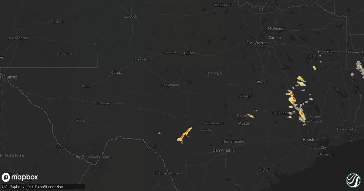
Hail Map in Texas on April 30, 2022
Get this storm
April 30 map
$229
one time, instant access
Download today. No call, no setup
Keep the $229
Bought the map and want the full workflow? Apply the entire $229 to a subscription within 7 days. None of it is wasted.
Every map, not just this one
This buys you this map. Subscription and you get every map we run, in the markets you choose from a few cities to whole states to nationwide. Plus real-time alerts the moment a storm fires.
Contact data
Name, contact info, occupancy, even credit band for addresses in the footprint. You go from where it hit to who to call.
Become the source they trust
Unlimited branding weather history reports on demand. You already have the documented answer ready for the property owner, and you are the one who showed up with it.
Property data and RoofTrace estimates
Pull up any address you have got, its value and the exact code rules for that jurisdiction, straight from One Click Code. Then RoofTrace estimates the squares, pitch, and roof value, priced the way you price.
Storm reports in Texas
Texas
| Date | Description |
|---|---|
| 04/30/20226:36 PM CDT | A local report indicates 1.25 inch wind near 7 SW PALESTINE |
| 04/30/20225:58 PM CDT | Report from mping: quarter |
| 04/30/20225:15 PM CDT | Lots of dime to quarter sized hail reported from the brushy creek rv park. Delayed report... Time estimated by radar. |
| 04/30/20224:50 PM CDT | A local report indicates 1.25 inch wind near HUTTO |
| 04/30/20224:48 PM CDT | Report from mping: golf ball |
| 04/30/20224:32 PM CDT | Report from mping: half dollar |
| 04/30/20225:20 AM CDT | At 1020 PM CDT, a severe thunderstorm was located 10 miles north of Montgomery, or 13 miles southwest of Huntsville, moving south at 20 mph. HAZARD...60 mph wind gusts and quarter size hail. SOURCE...Radar indicated. IMPACT...Hail damage to vehicles is expected. Expect wind damage to roofs, siding, and trees. Locations impacted include... Northwestern Conroe, Willis, Panorama Village, Montgomery and Lake Conroe Dam. |
| 04/30/20225:09 AM CDT | At 1009 PM CDT, a severe thunderstorm was located 8 miles southwest of Huntsville, moving southeast at 25 mph. HAZARD...Quarter size hail. SOURCE...Radar indicated. IMPACT...Damage to vehicles is expected. Locations impacted include... Huntsville, New Waverly and Huntsville State Park. |
| 04/30/20224:30 AM CDT | At 930 PM CDT, severe thunderstorms were located along a line extending from near Loma Alta to 11 miles northeast of Carta Valley, moving east at 10 mph. HAZARD...Quarter size hail. SOURCE...Radar indicated. IMPACT...Damage to vehicles is expected. Locations impacted include... Loma Alta, Vinegarone and Devils River State Nat Area Del Norte. |
| 04/30/20224:25 AM CDT | At 925 PM CDT, severe thunderstorms were located along a line extending from 7 miles east of Kurten to 8 miles southeast of Bedias to 6 miles north of Huntsville to Trinity, moving southeast at 20 mph. HAZARD...Quarter size hail. SOURCE...Radar indicated. IMPACT...Damage to vehicles is expected. Locations impacted include... Huntsville, Trinity, Onalaska, New Waverly, Point Blank, Riverside, Bedias, Sebastopol, Huntsville State Park, Iola, Crabbs Prairie and Oakhurst. |
| 04/30/20224:00 AM CDT | At 859 PM CDT, severe thunderstorms were located along a line extending from 10 miles west of Riverside to 6 miles northeast of Bedias to 10 miles east of Kurten, moving southeast at 15 mph. HAZARD...Quarter size hail. SOURCE...Radar indicated. IMPACT...Damage to vehicles is expected. Locations impacted include... Huntsville, Madisonville, Point Blank, Riverside, Bedias, Kurten, Iola, Crabbs Prairie and Oakhurst. |
| 04/30/20223:13 AM CDT | At 813 PM CDT, severe thunderstorms were located along a line extending from 15 miles northeast of Kurten to near Madisonville, moving southeast at 10 mph. HAZARD...60 mph wind gusts and quarter size hail. SOURCE...Radar indicated. IMPACT...Hail damage to vehicles is expected. Expect wind damage to roofs, siding, and trees. Locations impacted include... Madisonville and North Zulch. |
| 04/30/20223:08 AM CDT | At 808 PM CDT, a severe thunderstorm was located 16 miles north of Tuff, or 19 miles north of Leakey, moving northeast at 10 mph. HAZARD...Ping pong ball size hail and 60 mph wind gusts. SOURCE...Radar indicated. IMPACT...People and animals outdoors will be injured. Expect hail damage to roofs, siding, windows, and vehicles. Expect wind damage to roofs, siding, and trees. Locations impacted include... Kerr Wildlife Management Area and Prade Ranch. |
| 04/30/20222:58 AM CDT | At 758 PM CDT, a severe thunderstorm was located near Ponta, or 7 miles east of Jacksonville, moving southeast at 15 mph. HAZARD...60 mph wind gusts and quarter size hail. SOURCE...Radar indicated. IMPACT...Hail damage to vehicles is expected. Expect wind damage to roofs, siding, and trees. Locations impacted include... Jacksonville, Rusk, Sacul, New Salem, Ponta, New Summerfield, Gallatin, Reklaw and Laneville. |
| 04/30/20222:53 AM CDT | At 753 PM CDT, severe thunderstorms were located along a line extending from 9 miles southwest of Grapeland to 6 miles west of Crockett, moving east at 10 mph. HAZARD...Quarter size hail. SOURCE...Radar indicated. IMPACT...Damage to vehicles is expected. Locations impacted include... Crockett, Grapeland and Latexo. |
| 04/30/20222:48 AM CDT | At 748 PM CDT, a severe thunderstorm was located near Conroe, moving east at 10 mph. HAZARD...Quarter size hail. SOURCE...Radar indicated. IMPACT...Damage to vehicles is expected. Locations impacted include... Conroe, The Woodlands, Oak Ridge North, Shenandoah, Cut And Shoot, Woodloch, The Woodlands Pavillion, Porter Heights and Chateau Woods. |
| 04/30/20222:30 AM CDT | At 729 PM CDT, a severe thunderstorm was located over Barksdale, or 16 miles west of Leakey, and is nearly stationary. HAZARD...60 mph wind gusts and quarter size hail. SOURCE...Radar indicated. IMPACT...Hail damage to vehicles is expected. Expect wind damage to roofs, siding, and trees. Locations impacted include... Camp Wood and Barksdale. |
| 04/30/20222:28 AM CDT | At 727 PM CDT, a severe thunderstorm was located 8 miles northwest of Madisonville, moving east at 20 mph. HAZARD...60 mph wind gusts and half dollar size hail. SOURCE...Radar indicated. IMPACT...Hail damage to vehicles is expected. Expect wind damage to roofs, siding, and trees. Locations impacted include... Madisonville. |
| 04/30/20222:26 AM CDT | At 726 PM CDT, a severe thunderstorm was located 10 miles northeast of Vance, or 17 miles northwest of Leakey, moving northeast at 20 mph. HAZARD...Golf ball size hail and 60 mph wind gusts. SOURCE...Radar indicated. IMPACT...People and animals outdoors will be injured. Expect hail damage to roofs, siding, windows, and vehicles. Expect wind damage to roofs, siding, and trees. This severe thunderstorm will remain over mainly rural areas of west central Kerr, northeastern Edwards and northwestern Real Counties. |
| 04/30/20222:14 AM CDT | At 713 PM CDT, a severe thunderstorm was located 10 miles northwest of Madisonville, moving east at 20 mph. HAZARD...Quarter size hail. SOURCE...Radar indicated. IMPACT...Damage to vehicles is expected. Locations impacted include... Madisonville and Normangee. |
| 04/30/20222:13 AM CDT | At 713 PM CDT, a severe thunderstorm was located near Tuff, or 9 miles north of Leakey, moving northeast at 5 mph. HAZARD...60 mph wind gusts and quarter size hail. SOURCE...Radar indicated. IMPACT...Hail damage to vehicles is expected. Expect wind damage to roofs, siding, and trees. Locations impacted include... Lost Maples State Natural Area, Tuff and Prade Ranch. |
| 04/30/20222:01 AM CDT | At 700 PM CDT, a severe thunderstorm was located over Mixon, or near Jacksonville, moving east at 15 mph. HAZARD...60 mph wind gusts and quarter size hail. SOURCE...Radar indicated. IMPACT...Hail damage to vehicles is expected. Expect wind damage to roofs, siding, and trees. Locations impacted include... Jacksonville, Mount Selman, Mixon, New Salem, Ponta, New Summerfield, Gallatin, Reklaw and Concord. |
| 04/30/20222:01 AM CDT | At 701 PM CDT, a severe thunderstorm was located near Grapeland, or 14 miles northwest of Crockett, moving east at 30 mph. HAZARD...Quarter size hail. SOURCE...Radar indicated. IMPACT...Damage to vehicles is expected. Locations impacted include... Crockett, Grapeland and Latexo. |
| 04/30/20221:57 AM CDT | At 657 PM CDT, a severe thunderstorm was located 13 miles west of Elkhart, or 15 miles southwest of Palestine, moving east at 10 mph. HAZARD...Quarter size hail. SOURCE...Radar indicated. IMPACT...Damage to vehicles is possible. This severe thunderstorm will remain over mainly rural areas of northeastern Leon and south central Anderson Counties. |
| 04/30/20221:55 AM CDT | At 655 PM CDT, a severe thunderstorm was located over Turnertown, or 9 miles west of Henderson, moving east at 10 mph. HAZARD...60 mph wind gusts and half dollar size hail. SOURCE...Radar indicated. IMPACT...Hail damage to vehicles is expected. Expect wind damage to roofs, siding, and trees. Locations impacted include... Henderson, Overton, New London, Turnertown, Joinerville, Oak Hill and Brachfield. |
| 04/30/20221:31 AM CDT | At 630 PM CDT, a pair of severe thunderstorms were located along a line extending from near Centerville to 20 miles northeast of Franklin, moving east at 10 mph. HAZARD...Quarter size hail. SOURCE...Radar indicated. IMPACT...Damage to vehicles is possible. Locations impacted include... Centerville and Leona. This includes Interstate 45 between mile markers 152 and 168. |
| 04/30/20221:27 AM CDT | At 626 PM CDT, a severe thunderstorm was located 7 miles northwest of Barksdale, or 16 miles south of Rocksprings, moving northeast at 15 mph. HAZARD...Golf ball size hail and 60 mph wind gusts. SOURCE...Radar indicated. IMPACT...People and animals outdoors will be injured. Expect hail damage to roofs, siding, windows, and vehicles. Expect wind damage to roofs, siding, and trees. Locations impacted include... Vance, Barksdale, Devil's Sinkhole State Natural Area and Prade Ranch. |
| 04/30/202212:48 AM CDT | At 548 PM CDT, a severe thunderstorm was located near Palestine, moving southeast at 10 mph. HAZARD...60 mph wind gusts and quarter size hail. SOURCE...Radar indicated. IMPACT...Hail damage to vehicles is expected. Expect wind damage to roofs, siding, and trees. Locations impacted include... Palestine and Elkhart. |
| 04/30/202212:08 AM CDT | At 507 PM CDT, a severe thunderstorm was located near Coupland, or near Pflugerville, moving east at 15 mph. HAZARD...60 mph wind gusts and half dollar size hail. SOURCE...Radar indicated. IMPACT...Hail damage to vehicles is expected. Expect wind damage to roofs, siding, and trees. Locations impacted include... Pflugerville, Elgin, Hutto, Coupland, Rices Crossing, Beyarsville, McDade and Butler. |
| 04/29/202211:37 PM CDT | At 436 PM CDT, a severe thunderstorm was located over Hutto, or near Pflugerville, moving east at 15 mph. HAZARD...Quarter size hail. SOURCE...Trained weather spotters. IMPACT...Damage to vehicles is expected. Locations impacted include... Round Rock, Taylor, Hutto, Coupland, Rices Crossing, Noack and Beyarsville. |
| 04/29/20228:45 PM CDT | Golf to ping-pong ball sized hail near madisonville |
| 04/29/20227:50 PM CDT | Ping-pongball sized hail near madisonville |
| 04/29/20227:10 PM CDT | Social media photo. |
| 04/29/20227:00 PM CDT | A local report indicates 1.00 inch wind near 1 E LEONA |
All States Impacted by Hail Map on April 30, 2022
Cities Impacted by Hail Map on April 30, 2022
- Arkadelphia, AR
- Gurdon, AR
- Sparkman, AR
- Farmington, MO
- Chester, IL
- Percy, IL
- Steeleville, IL
- Cutler, IL
- Pinckneyville, IL
- Campbell Hill, IL
- Saint Mary, MO
- Sainte Genevieve, MO
- Perryville, MO
- Rockwood, IL
- Morganfield, KY
- Anderson, TX
- Elkhart, TX
- Oakwood, TX
- Palestine, TX
- Grapeland, TX
- Provencal, LA
- Dubach, LA
- Atlanta, IL
- Lexa, AR
- Marianna, AR
- Buffalo, TX
- Labelle, FL
- Lehigh Acres, FL
- Jacksonville, TX
- Ellsinore, MO
- Van Buren, MO
- Hineston, LA
- Glenmora, LA
- Leesville, LA
- Moweaqua, IL
- Madisonville, TX
- North Zulch, TX
- Normangee, TX
- Monroe, LA
- Griffithville, AR
- Cherry Valley, IL
- Kirkland, IL
- Belvidere, IL
- Fredericktown, MO
- Bedias, TX
- Coupland, TX
- Taylor, TX
- Hutto, TX
- Manor, TX
- Minooka, IL
- Grayson, LA
- Columbia, LA
- Granger, TX
- Pflugerville, TX
- Round Rock, TX
- Columbus, MS
- Waynesville, IL
- Clinton, IL
- Ullin, IL
- Tamms, IL
- Pulaski, IL
- Chipley, FL
- Bonifay, FL
- McLean, IL
- Downs, IL
- Williamsville, IL
- Elkhart, IL
- Heyworth, IL
- Lawndale, IL
- Bloomington, IL
- Shirley, IL
- Lincoln, IL
- Lovington, IL
- Hammond, IL
- Atwood, IL
- Rosston, AR
- Chana, IL
- Davis Junction, IL
- Rochelle, IL
- Des Arc, AR
- Ward, AR
- Carlisle, AR
- Kinsman, IL
- Cornell, IL
- Ransom, IL
- Blackstone, IL
- West Point, MS
- Stonington, IL
- Mansfield, LA
- Du Quoin, IL
- Vergennes, IL
- Elkville, IL
- Doe Run, MO
- Ironton, MO
- Ava, IL
- Macon, IL
- Hampton, AR
- Harrell, AR
- Tupelo, MS
- Belden, MS
- Pontotoc, MS
- Delhi, LA
- Strong, AR
- Junction City, AR
- El Dorado, AR
- Barksdale, TX
- Leakey, TX
- Camp Wood, TX
- Magnolia, AR
- McNeil, AR
- Olmsted, IL
- Villa Ridge, IL
- Mounds, IL
- Carterville, IL
- Hurst, IL
- Murphysboro, IL
- Royalton, IL
- De Soto, IL
- Brownstown, IL
- Palmer, IL
- Taylorville, IL
- Morrisonville, IL
- Hazel Green, WI
- Cuba City, WI
- Platteville, WI
- Rockfield, KY
- Bowling Green, KY
- Ashton, IL
- Holcomb, IL
- Monroe Center, IL
- Garden Prairie, IL
- Rockford, IL
- Milmine, IL
- Dalton City, IL
- Decatur, IL
- Blue Mound, IL
- Cerro Gordo, IL
- Bement, IL
- Argenta, IL
- Mt Zion, IL
- Oxford, MS
- Hermitage, AR
- Jersey, AR
- Chatsworth, IL
- Strawn, IL
- Danforth, IL
- Gilman, IL
- Ashkum, IL
- Forrest, IL
- Piper City, IL
- Steens, MS
- Millport, AL
- Advance, MO
- Marion, LA
- Senatobia, MS
- Tunica, MS
- Sarah, MS
- Dundee, MS
- Iola, TX
- Beatrice, AL
- Jacob, IL
- Houston, MS
- Mantee, MS
- Prairie, MS
- Woodland, MS
- Cedarbluff, MS
- Mountain Home, TX
- Rocksprings, TX
- Hunt, TX
- Brinkley, AR
- Centerville, TX
- Leona, TX
- Marquez, TX
- Brownsville, KY
- Robeline, LA
- Knightstown, IN
- Estero, FL
- Bonita Springs, FL
- Farmersville, IL
- Harvel, IL
- Moro, AR
- Many, LA
- Natchitoches, LA
- Marthaville, LA
- University, MS
- Converse, LA
- Shelbyville, TX
- Greenville, MO
- Parkers Lake, KY
- Batesville, MS
- Abbeville, MS
- Sardis, MS
- Taylor, MS
- Hamilton, MS
- Caledonia, MS
- Ethelsville, AL
- Vernon, AL
- Sulligent, AL
- Poplar Grove, IL
- Lindenwood, IL
- Stillman Valley, IL
- Oregon, IL
- Franklin Grove, IL
- Byron, IL
- Kennedy, AL
- Marquand, MO
- Carrollton, AL
- Gorham, IL
- Frohna, MO
- Marks, MS
- Ruston, LA
- Choudrant, LA
- Park Hills, MO
- Wenona, IL
- Tonica, IL
- Streator, IL
- Auburn, IL
- Lakeland, FL
- Jewett, TX
- Conroe, TX
- Magnolia, TX
- Spring, TX
- Western Springs, IL
- Hinsdale, IL
- Lockport, IL
- Willowbrook, IL
- Woodridge, IL
- Darien, IL
- Lemont, IL
- Jetson, KY
- Sweeden, KY
- Bee Spring, KY
- Roundhill, KY
- Mammoth Cave, KY
- Freeman Spur, IL
- Ellis Grove, IL
- Zeigler, IL
- Mulkeytown, IL
- West Frankfort, IL
- Herrin, IL
- Dowell, IL
- Collinston, LA
- Bastrop, LA
- Montgomery, TX
- Fairbury, IL
- Cropsey, IL
- Colfax, IL
- Ellington, MO
- Eufaula, AL
- Clayton, AL
- Albion, IL
- Saint Elmo, IL
- Vandalia, IL
- Saint Peter, IL
- Waldo, AR
- Del Rio, TX
- North Port, FL
- Biscoe, AR
- Cotton Plant, AR
- Wheatley, AR
- Aubrey, AR
- Lawrenceville, IL
- Navasota, TX
- Mill Spring, MO
- Delavan, IL
- Danvers, IL
- Minier, IL
- Stanford, IL
- Armington, IL
- Hopedale, IL
- La Center, KY
- Prescott, AR
- Aberdeen, MS
- Sterlington, LA
- Kincaid, IL
- Pawnee, IL
- Starkville, MS
- Pleasant Hill, LA
- Browns, IL
- Chidester, AR
- Patterson, MO
- Sarasota, FL
- Camden, AR
- Bearden, AR
- Gordo, AL
- Aliceville, AL
- Brooksville, MS
- Reform, AL
- Plainfield, IL
- Yorkville, IL
- Marseilles, IL
- Grand Ridge, IL
- Rayville, LA
- Mangham, LA
- Troy, AL
- Union Springs, AL
- Mount Holly, AR
- Smackover, AR
- Doerun, GA
- Albany, GA
- La Grange, IL
- La Grange Park, IL
- Romeoville, IL
- Downers Grove, IL
- Silva, MO
- Lodi, MO
- Glenallen, MO
- Clubb, MO
- West Monroe, LA
- Palmyra, IL
- Carlinville, IL
- Girard, IL
- Edinburg, IL
- Waggoner, IL
- Assumption, IL
- New Douglas, IL
- Martin, TN
- Huntsville, TX
- Richards, TX
- Willis, TX
- Morris, IL
- Crockett, TX
- Cabot, AR
- Vilonia, AR
- Montgomery, AL
- Northport, AL
- Groveland, FL
- New Waverly, TX
- Oldsmar, FL
- Palm Harbor, FL
- Oran, MO
- Bell City, MO
- Jackson, AL
- Gipsy, MO
- Fremont, MO
- Piedmont, MO
- Wappapello, MO
- Lowndes, MO
- Zalma, MO
- Berry, AL
- Coldwater, MS
- Eaton Park, FL
- Eros, LA
- Oak Ridge, LA
- Mer Rouge, LA
- Loves Park, IL
- Machesney Park, IL
- Oakdale, LA
- Trinity, TX
- Water Valley, MS
- Calhoun, LA
- Athens, IL
- Greenview, IL
- Middletown, IL
- New Holland, IL
- Zolfo Springs, FL
- Immokalee, FL
- Flat Rock, IL
- Naples, FL
- Grand Chain, IL
- Crystal River, FL
- Lecanto, FL
- Farmerville, LA
- Cave City, KY
- Gladewater, TX
- Winona, TX
- Winnsboro, LA
- Crossett, AR
- Stephens, AR
- Selman City, TX
- Troup, TX
- Overton, TX
- Henderson, TX
- Flanagan, IL
- Carthage, AR
- Thayer, IL
- Chatham, IL
- Glenarm, IL
- Virden, IL
- Patton, MO
- Des Arc, MO
- Poplar Grove, AR
- Marvell, AR
- Thorndale, TX
- Banks, AR
- Spearsville, LA
- Parrish, AL
- Arcadia, MO
- Annapolis, MO
- Lovelady, TX
- Karnak, IL
- Olla, LA
- Kelly, LA
- Holly Grove, AR
- Walshville, IL
- Sorento, IL
- Tampa, FL
- Marble Hill, MO
- Eagle Lake, FL
- Bartow, FL
- Auburndale, FL
- Winter Haven, FL
- Gilbert, LA
- Winnebago, IL
- Caledonia, IL
- Roscoe, IL
- Brooksville, FL
- Friars Point, MS
- Coahoma, MS
- Helena, AR
- Punta Gorda, FL
- Arcadia, FL
- Mazon, IL
- Odell, IL
- Verona, IL
- Dwight, IL
- Horse Cave, KY
- Glasgow, KY
- Homer Glen, IL
- Kilgore, TX
- Grandin, MO
- Frierson, LA
- Coushatta, LA
- Grand Cane, LA
- Pelican, LA
- Ringgold, LA
- Newark, IL
- Etoile, TX
- Genoa, IL
- Kingston, IL
- Como, MS
- Riverside, OR
- Spiceland, IN
- Farrar, MO
- Bonfield, IL
- Wilmington, IL
- Malvern, AR
- Benton, AR
- Morgantown, KY
- Caneyville, KY
- Austin, AR
- West Helena, AR
- Crenshaw, MS
- Sledge, MS
- Clifton, IL
- Sibley, IL
- Placida, FL
- Oak Brook, IL
- Hamburg, AR
- Springfield, IL
- Oswego, IL
- Joliet, IL
- Shorewood, IL
- Towanda, IL
- Lexington, IL
- Hudson, IL
- Normal, IL
- Kempton, IL
- Ellsworth, IL
- Arrowsmith, IL
- Onarga, IL
- Anchor, IL
- Le Roy, IL


