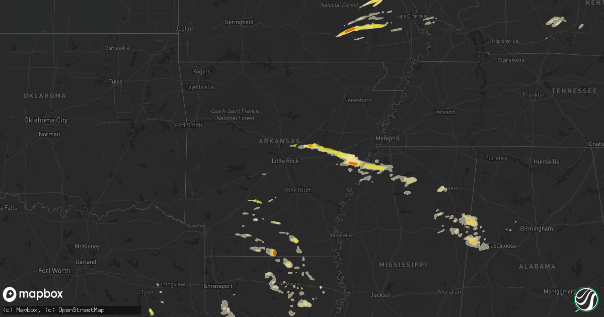
Hail Map in Arkansas on April 30, 2022
Get this storm
April 30 map
$229
one time, instant access
Download today. No call, no setup
Keep the $229
Bought the map and want the full workflow? Apply the entire $229 to a subscription within 7 days. None of it is wasted.
Every map, not just this one
This buys you this map. Subscription and you get every map we run, in the markets you choose from a few cities to whole states to nationwide. Plus real-time alerts the moment a storm fires.
Contact data
Name, contact info, occupancy, even credit band for addresses in the footprint. You go from where it hit to who to call.
Become the source they trust
Unlimited branding weather history reports on demand. You already have the documented answer ready for the property owner, and you are the one who showed up with it.
Property data and RoofTrace estimates
Pull up any address you have got, its value and the exact code rules for that jurisdiction, straight from One Click Code. Then RoofTrace estimates the squares, pitch, and roof value, priced the way you price.
Storm reports in Arkansas
Arkansas
| Date | Description |
|---|---|
| 04/30/20226:52 PM CDT | A video posted to social media showed either a brief... Weak tornado or gustnado south of des arc. There was apparent minor damage to some outbuildings at skarda farms. |
| 04/30/20226:14 PM CDT | A tornado was reported at tull... Blowing trees down. The tornado was reported to be very small and weak... And apparently brief. |
| 04/30/20226:08 PM CDT | A local report indicates 1.50 inch wind near 1 N HICKORY PLAINS |
| 04/30/20225:50 PM CDT | A tree was blown down across highway 38. |
| 04/30/20225:19 PM CDT | Nickel to quarter sized hail was reported in greystone near cabot. Report relayed by broadcast media |
| 04/30/20226:17 AM CDT | At 1117 PM CDT, a severe thunderstorm was located 11 miles south of Huttig, moving southeast at 30 mph. HAZARD...60 mph wind gusts and quarter size hail. SOURCE...Radar indicated. IMPACT...Hail damage to vehicles is expected. Expect wind damage to roofs, siding, and trees. Locations impacted include... Marion, Cecil, Spencer, Linville, Haile and Litroe. |
| 04/30/20225:13 AM CDT | At 1012 PM CDT, a severe thunderstorm was located near Urbana, or 9 miles southeast of El Dorado, moving east at 25 mph. HAZARD...60 mph wind gusts and half dollar size hail. SOURCE...Radar indicated. IMPACT...Hail damage to vehicles is expected. Expect wind damage to roofs, siding, and trees. Locations impacted include... El Dorado, Huttig, Strong, Lapile, Urbana, Lawson, Felsenthal, Hillsboro, Lockhart, New London, Aurelle and Pigeon Hill. |
| 04/30/20225:05 AM CDT | At 1005 PM CDT, a severe thunderstorm was located 7 miles southeast of Ingalls, or 10 miles north of West Crossett, moving southeast at 20 mph. HAZARD...60 mph wind gusts and half dollar size hail. SOURCE...Radar indicated. IMPACT...Hail damage to vehicles is expected. Expect wind damage to roofs, siding, and trees. Locations impacted include... Crossett, Hamburg, North Crossett, West Crossett, Fountain Hill, Old Milo and Blanchton. |
| 04/30/20224:56 AM CDT | At 955 PM CDT, a severe thunderstorm was located near Ingalls, or 15 miles north of West Crossett, moving east at 15 mph. HAZARD...Quarter size hail. SOURCE...Radar indicated. IMPACT...Damage to vehicles is expected. Locations impacted include... Hermitage... Ingalls... Ladelle... Prairie Grove... Vick... Valley... Mt Olive in Bradley County... Johnsonville... Sumpter... Lacey... |
| 04/30/20224:13 AM CDT | At 913 PM CDT, a severe thunderstorm was located near Tunica, or 8 miles northeast of St Francis National Park, moving east at 25 mph. HAZARD...60 mph wind gusts and quarter size hail. SOURCE...Radar indicated. IMPACT...Hail damage to vehicles is expected. Expect wind damage to roofs, siding, and trees. Locations impacted include... Tunica, North Tunica, Dubbs, Little Texas, Dooley, Savage, Maud, Fox Island, Austin, Clayton, Hollywood, Prichard and Evansville. |
| 04/30/20224:04 AM CDT | At 904 PM CDT, a severe thunderstorm was located near Wesson, or 9 miles northwest of Junction City, moving east at 25 mph. HAZARD...60 mph wind gusts and half dollar size hail. SOURCE...Radar indicated. IMPACT...Hail damage to vehicles is expected. Expect wind damage to roofs, siding, and trees. Locations impacted include... El Dorado, Smackover, Norphlet, Junction City, Strong, Calion, Mount Holly, Atlanta, Wesson, Village, Lisbon, Urbana, Lawson, Lapile, Newell, New London, Pigeon Hill, Kenova, Spotville and Medlock. |
| 04/30/20223:08 AM CDT | At 807 PM CDT, a severe thunderstorm was located over Stephens, or 9 miles northeast of McNeil, moving east at 15 mph. HAZARD...60 mph wind gusts and quarter size hail. SOURCE...Radar indicated. IMPACT...Hail damage to vehicles is expected. Expect wind damage to roofs, siding, and trees. Locations impacted include... Stephens... |
| 04/30/20223:00 AM CDT | At 759 PM CDT, a severe thunderstorm was located 7 miles southeast of Harlow, or 7 miles north of Hampton, moving east at 20 mph. HAZARD...60 mph wind gusts and quarter size hail. SOURCE...Radar indicated. IMPACT...Hail damage to vehicles is expected. Expect wind damage to roofs, siding, and trees. Locations impacted include... Marks Mill State Park... Weeks... Ellisville... Banks... Tinsman... Woodberry... New Edinburg... |
| 04/30/20222:27 AM CDT | At 727 PM CDT, a severe thunderstorm was located near Fredonia, or 7 miles northeast of De Valls Bluff, moving east at 30 mph. HAZARD...60 mph wind gusts and quarter size hail. SOURCE...Radar indicated. IMPACT...Hail damage to vehicles is expected. Expect wind damage to roofs, siding, and trees. Locations impacted include... Brinkley... Fredonia... Alfrey... Allendale... Cotton Plant... Fargo... Dagmar WMA... Keevil... Sand Hill... Little Dixie... Brasfield... Zent...This includes Interstate 40 between mile markers 198 and 218. |
| 04/30/20221:53 AM CDT | At 653 PM CDT, a severe thunderstorm was located near Cane Creek, or 8 miles north of Sheridan, moving east at 25 mph. HAZARD...60 mph wind gusts and quarter size hail. SOURCE...Radar indicated. IMPACT...Hail damage to vehicles is expected. Expect wind damage to roofs, siding, and trees. Locations impacted include... Redfield... Tull... Orion... Cane Creek... Pine Bluff Arsenal... Belfast... Hensley... Jefferson... Kearney... Buie... Ico... Woodson... F.B. Baugh Recreation Area... Tar Camp Park...This includes Interstate 530 between mile markers 13 and 25. |
| 04/30/20221:40 AM CDT | At 640 PM CDT, a severe thunderstorm was located 7 miles northeast of Poison Springs State Park, or 8 miles north of Camden, moving east at 25 mph. HAZARD...60 mph wind gusts and quarter size hail. SOURCE...Radar indicated. IMPACT...Hail damage to vehicles is expected. Expect wind damage to roofs, siding, and trees. Locations impacted include... Camden... Bearden... Highland Industrial Park... East Camden... Amy... Warner... Eagle Mills... Harmony Grove... Millville... |
| 04/30/20221:35 AM CDT | At 634 PM CDT, a severe thunderstorm was located near Waldo, moving northeast at 15 mph. HAZARD...60 mph wind gusts and half dollar size hail. SOURCE...Radar indicated. IMPACT...Hail damage to vehicles is expected. Expect wind damage to roofs, siding, and trees. Locations impacted include... Magnolia, Waldo, McNeil, Willisville, Young, College Hill, Lamartine, Laughlin, Medlock and Waterloo. |
| 04/30/20221:12 AM CDT | At 612 PM CDT, a severe thunderstorm was located over Thurman, or 13 miles west of Des Arc, moving east at 15 mph. HAZARD...Ping pong ball size hail and 60 mph wind gusts. SOURCE...Radar indicated. IMPACT...People and animals outdoors will be injured. Expect hail damage to roofs, siding, windows, and vehicles. Expect wind damage to roofs, siding, and trees. Locations impacted include... Des Arc... Thurman... Vinity Corner... Sand Hill... Jasmine... Hayley... Childers... Hickory Plains... McClelland... Georgetown... Butlerville... |
| 04/30/202212:50 AM CDT | At 549 PM CDT, a severe thunderstorm was located over Haskell, or near Benton, moving east at 25 mph. HAZARD...60 mph wind gusts and quarter size hail. SOURCE...Radar indicated. IMPACT...Hail damage to vehicles is expected. Expect wind damage to roofs, siding, and trees. Locations impacted include... Benton... Bryant... Haskell... Traskwood... Tull... Cane Creek... East End... Bauxite... Belfast... Sardis... Shaw... Glen Rose... Ico... Vimy Ridge... Parkers-Iron Springs... This includes Interstate 30 between mile markers 104 and 117. |
| 04/30/202212:44 AM CDT | At 543 PM CDT, a severe thunderstorm was located near Whelen Springs, or 19 miles east of Prescott, moving east at 25 mph. HAZARD...60 mph wind gusts and quarter size hail. SOURCE...Radar indicated. IMPACT...Hail damage to vehicles is expected. Expect wind damage to roofs, siding, and trees. Locations impacted include... Sparkman... Whelen Springs... Amy... Tates Bluff... Pine Grove... Ouachita... Holly Springs... Reader... Vaden... |
| 04/30/202212:41 AM CDT | At 541 PM CDT, a severe thunderstorm was located over Old Austin, or over Cabot, moving east at 30 mph. HAZARD...60 mph wind gusts and quarter size hail. SOURCE...Radar indicated. IMPACT...Hail damage to vehicles is expected. Expect wind damage to roofs, siding, and trees. Locations impacted include... Cabot... Beebe... Ward... Austin in Lonoke County... Thurman... Old Austin... Parnell... Sylvania... McRae... Griffithville... Vinity Corner... Walker... Hayley... Butlerville... Childers... Hickory Plains... Woodlawn... Jasmine...This includes US Highway 67 between mile markers 17 and 31. |
| 04/30/202212:07 AM CDT | At 507 PM CDT, a severe thunderstorm was located near Cabot, moving east at 35 mph. HAZARD...60 mph wind gusts and quarter size hail. SOURCE...Radar indicated. IMPACT...Hail damage to vehicles is expected. Expect wind damage to roofs, siding, and trees. Locations impacted include... Jacksonville... Cabot... Little Rock AFB... Beebe... Ward... Vilonia... Austin in Lonoke County... Old Austin... Parnell... McRae... Sylvania... Antioch in White County... El Paso... Otto... Butlerville... Woodlawn... Macon... This includes US Highway 67 between mile markers 13 and 35. |
| 04/29/202211:48 PM CDT | At 447 PM CDT, a severe thunderstorm was located near Richwoods, or 7 miles southeast of Arkadelphia, moving east at 25 mph. HAZARD...60 mph wind gusts and quarter size hail. SOURCE...Radar indicated. IMPACT...Hail damage to vehicles is expected. Expect wind damage to roofs, siding, and trees. Locations impacted include... Arkadelphia... Dalark... Joan... Griffithtown... Manning... Willow... |
| 04/29/20229:59 PM CDT | Quarter size hail near the intersection of iron mountain road and us hwy 167. |
| 04/29/20229:38 PM CDT | Golf ball sized hail 4 mlies north of rondo. |
| 04/29/20229:00 PM CDT | Photo of walnut-sized hail along highway 261 near holub crossing. |
| 04/29/20227:52 PM CDT | Hail of dime to quarter size was falling on the north side of brinkley. |
| 04/29/20227:01 PM CDT | A local report indicates 1.00 inch wind near DES ARC |
All States Impacted by Hail Map on April 30, 2022
Cities Impacted by Hail Map on April 30, 2022
- Arkadelphia, AR
- Gurdon, AR
- Sparkman, AR
- Farmington, MO
- Chester, IL
- Percy, IL
- Steeleville, IL
- Cutler, IL
- Pinckneyville, IL
- Campbell Hill, IL
- Saint Mary, MO
- Sainte Genevieve, MO
- Perryville, MO
- Rockwood, IL
- Morganfield, KY
- Anderson, TX
- Elkhart, TX
- Oakwood, TX
- Palestine, TX
- Grapeland, TX
- Provencal, LA
- Dubach, LA
- Atlanta, IL
- Lexa, AR
- Marianna, AR
- Buffalo, TX
- Labelle, FL
- Lehigh Acres, FL
- Jacksonville, TX
- Ellsinore, MO
- Van Buren, MO
- Hineston, LA
- Glenmora, LA
- Leesville, LA
- Moweaqua, IL
- Madisonville, TX
- North Zulch, TX
- Normangee, TX
- Monroe, LA
- Griffithville, AR
- Cherry Valley, IL
- Kirkland, IL
- Belvidere, IL
- Fredericktown, MO
- Bedias, TX
- Coupland, TX
- Taylor, TX
- Hutto, TX
- Manor, TX
- Minooka, IL
- Grayson, LA
- Columbia, LA
- Granger, TX
- Pflugerville, TX
- Round Rock, TX
- Columbus, MS
- Waynesville, IL
- Clinton, IL
- Ullin, IL
- Tamms, IL
- Pulaski, IL
- Chipley, FL
- Bonifay, FL
- McLean, IL
- Downs, IL
- Williamsville, IL
- Elkhart, IL
- Heyworth, IL
- Lawndale, IL
- Bloomington, IL
- Shirley, IL
- Lincoln, IL
- Lovington, IL
- Hammond, IL
- Atwood, IL
- Rosston, AR
- Chana, IL
- Davis Junction, IL
- Rochelle, IL
- Des Arc, AR
- Ward, AR
- Carlisle, AR
- Kinsman, IL
- Cornell, IL
- Ransom, IL
- Blackstone, IL
- West Point, MS
- Stonington, IL
- Mansfield, LA
- Du Quoin, IL
- Vergennes, IL
- Elkville, IL
- Doe Run, MO
- Ironton, MO
- Ava, IL
- Macon, IL
- Hampton, AR
- Harrell, AR
- Tupelo, MS
- Belden, MS
- Pontotoc, MS
- Delhi, LA
- Strong, AR
- Junction City, AR
- El Dorado, AR
- Barksdale, TX
- Leakey, TX
- Camp Wood, TX
- Magnolia, AR
- McNeil, AR
- Olmsted, IL
- Villa Ridge, IL
- Mounds, IL
- Carterville, IL
- Hurst, IL
- Murphysboro, IL
- Royalton, IL
- De Soto, IL
- Brownstown, IL
- Palmer, IL
- Taylorville, IL
- Morrisonville, IL
- Hazel Green, WI
- Cuba City, WI
- Platteville, WI
- Rockfield, KY
- Bowling Green, KY
- Ashton, IL
- Holcomb, IL
- Monroe Center, IL
- Garden Prairie, IL
- Rockford, IL
- Milmine, IL
- Dalton City, IL
- Decatur, IL
- Blue Mound, IL
- Cerro Gordo, IL
- Bement, IL
- Argenta, IL
- Mt Zion, IL
- Oxford, MS
- Hermitage, AR
- Jersey, AR
- Chatsworth, IL
- Strawn, IL
- Danforth, IL
- Gilman, IL
- Ashkum, IL
- Forrest, IL
- Piper City, IL
- Steens, MS
- Millport, AL
- Advance, MO
- Marion, LA
- Senatobia, MS
- Tunica, MS
- Sarah, MS
- Dundee, MS
- Iola, TX
- Beatrice, AL
- Jacob, IL
- Houston, MS
- Mantee, MS
- Prairie, MS
- Woodland, MS
- Cedarbluff, MS
- Mountain Home, TX
- Rocksprings, TX
- Hunt, TX
- Brinkley, AR
- Centerville, TX
- Leona, TX
- Marquez, TX
- Brownsville, KY
- Robeline, LA
- Knightstown, IN
- Estero, FL
- Bonita Springs, FL
- Farmersville, IL
- Harvel, IL
- Moro, AR
- Many, LA
- Natchitoches, LA
- Marthaville, LA
- University, MS
- Converse, LA
- Shelbyville, TX
- Greenville, MO
- Parkers Lake, KY
- Batesville, MS
- Abbeville, MS
- Sardis, MS
- Taylor, MS
- Hamilton, MS
- Caledonia, MS
- Ethelsville, AL
- Vernon, AL
- Sulligent, AL
- Poplar Grove, IL
- Lindenwood, IL
- Stillman Valley, IL
- Oregon, IL
- Franklin Grove, IL
- Byron, IL
- Kennedy, AL
- Marquand, MO
- Carrollton, AL
- Gorham, IL
- Frohna, MO
- Marks, MS
- Ruston, LA
- Choudrant, LA
- Park Hills, MO
- Wenona, IL
- Tonica, IL
- Streator, IL
- Auburn, IL
- Lakeland, FL
- Jewett, TX
- Conroe, TX
- Magnolia, TX
- Spring, TX
- Western Springs, IL
- Hinsdale, IL
- Lockport, IL
- Willowbrook, IL
- Woodridge, IL
- Darien, IL
- Lemont, IL
- Jetson, KY
- Sweeden, KY
- Bee Spring, KY
- Roundhill, KY
- Mammoth Cave, KY
- Freeman Spur, IL
- Ellis Grove, IL
- Zeigler, IL
- Mulkeytown, IL
- West Frankfort, IL
- Herrin, IL
- Dowell, IL
- Collinston, LA
- Bastrop, LA
- Montgomery, TX
- Fairbury, IL
- Cropsey, IL
- Colfax, IL
- Ellington, MO
- Eufaula, AL
- Clayton, AL
- Albion, IL
- Saint Elmo, IL
- Vandalia, IL
- Saint Peter, IL
- Waldo, AR
- Del Rio, TX
- North Port, FL
- Biscoe, AR
- Cotton Plant, AR
- Wheatley, AR
- Aubrey, AR
- Lawrenceville, IL
- Navasota, TX
- Mill Spring, MO
- Delavan, IL
- Danvers, IL
- Minier, IL
- Stanford, IL
- Armington, IL
- Hopedale, IL
- La Center, KY
- Prescott, AR
- Aberdeen, MS
- Sterlington, LA
- Kincaid, IL
- Pawnee, IL
- Starkville, MS
- Pleasant Hill, LA
- Browns, IL
- Chidester, AR
- Patterson, MO
- Sarasota, FL
- Camden, AR
- Bearden, AR
- Gordo, AL
- Aliceville, AL
- Brooksville, MS
- Reform, AL
- Plainfield, IL
- Yorkville, IL
- Marseilles, IL
- Grand Ridge, IL
- Rayville, LA
- Mangham, LA
- Troy, AL
- Union Springs, AL
- Mount Holly, AR
- Smackover, AR
- Doerun, GA
- Albany, GA
- La Grange, IL
- La Grange Park, IL
- Romeoville, IL
- Downers Grove, IL
- Silva, MO
- Lodi, MO
- Glenallen, MO
- Clubb, MO
- West Monroe, LA
- Palmyra, IL
- Carlinville, IL
- Girard, IL
- Edinburg, IL
- Waggoner, IL
- Assumption, IL
- New Douglas, IL
- Martin, TN
- Huntsville, TX
- Richards, TX
- Willis, TX
- Morris, IL
- Crockett, TX
- Cabot, AR
- Vilonia, AR
- Montgomery, AL
- Northport, AL
- Groveland, FL
- New Waverly, TX
- Oldsmar, FL
- Palm Harbor, FL
- Oran, MO
- Bell City, MO
- Jackson, AL
- Gipsy, MO
- Fremont, MO
- Piedmont, MO
- Wappapello, MO
- Lowndes, MO
- Zalma, MO
- Berry, AL
- Coldwater, MS
- Eaton Park, FL
- Eros, LA
- Oak Ridge, LA
- Mer Rouge, LA
- Loves Park, IL
- Machesney Park, IL
- Oakdale, LA
- Trinity, TX
- Water Valley, MS
- Calhoun, LA
- Athens, IL
- Greenview, IL
- Middletown, IL
- New Holland, IL
- Zolfo Springs, FL
- Immokalee, FL
- Flat Rock, IL
- Naples, FL
- Grand Chain, IL
- Crystal River, FL
- Lecanto, FL
- Farmerville, LA
- Cave City, KY
- Gladewater, TX
- Winona, TX
- Winnsboro, LA
- Crossett, AR
- Stephens, AR
- Selman City, TX
- Troup, TX
- Overton, TX
- Henderson, TX
- Flanagan, IL
- Carthage, AR
- Thayer, IL
- Chatham, IL
- Glenarm, IL
- Virden, IL
- Patton, MO
- Des Arc, MO
- Poplar Grove, AR
- Marvell, AR
- Thorndale, TX
- Banks, AR
- Spearsville, LA
- Parrish, AL
- Arcadia, MO
- Annapolis, MO
- Lovelady, TX
- Karnak, IL
- Olla, LA
- Kelly, LA
- Holly Grove, AR
- Walshville, IL
- Sorento, IL
- Tampa, FL
- Marble Hill, MO
- Eagle Lake, FL
- Bartow, FL
- Auburndale, FL
- Winter Haven, FL
- Gilbert, LA
- Winnebago, IL
- Caledonia, IL
- Roscoe, IL
- Brooksville, FL
- Friars Point, MS
- Coahoma, MS
- Helena, AR
- Punta Gorda, FL
- Arcadia, FL
- Mazon, IL
- Odell, IL
- Verona, IL
- Dwight, IL
- Horse Cave, KY
- Glasgow, KY
- Homer Glen, IL
- Kilgore, TX
- Grandin, MO
- Frierson, LA
- Coushatta, LA
- Grand Cane, LA
- Pelican, LA
- Ringgold, LA
- Newark, IL
- Etoile, TX
- Genoa, IL
- Kingston, IL
- Como, MS
- Riverside, OR
- Spiceland, IN
- Farrar, MO
- Bonfield, IL
- Wilmington, IL
- Malvern, AR
- Benton, AR
- Morgantown, KY
- Caneyville, KY
- Austin, AR
- West Helena, AR
- Crenshaw, MS
- Sledge, MS
- Clifton, IL
- Sibley, IL
- Placida, FL
- Oak Brook, IL
- Hamburg, AR
- Springfield, IL
- Oswego, IL
- Joliet, IL
- Shorewood, IL
- Towanda, IL
- Lexington, IL
- Hudson, IL
- Normal, IL
- Kempton, IL
- Ellsworth, IL
- Arrowsmith, IL
- Onarga, IL
- Anchor, IL
- Le Roy, IL


