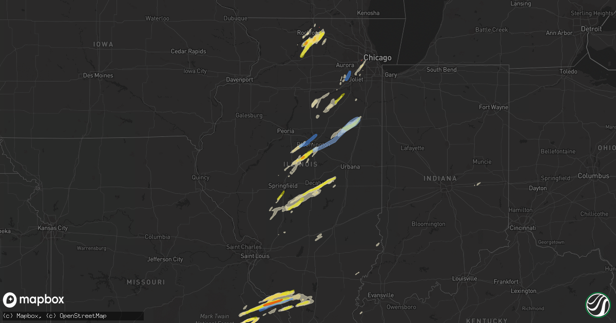
Hail Map in Illinois on April 30, 2022
Get this storm
April 30 map
$229
one time, instant access
Download today. No call, no setup
Keep the $229
Bought the map and want the full workflow? Apply the entire $229 to a subscription within 7 days. None of it is wasted.
Every map, not just this one
This buys you this map. Subscription and you get every map we run, in the markets you choose from a few cities to whole states to nationwide. Plus real-time alerts the moment a storm fires.
Contact data
Name, contact info, occupancy, even credit band for addresses in the footprint. You go from where it hit to who to call.
Become the source they trust
Unlimited branding weather history reports on demand. You already have the documented answer ready for the property owner, and you are the one who showed up with it.
Property data and RoofTrace estimates
Pull up any address you have got, its value and the exact code rules for that jurisdiction, straight from One Click Code. Then RoofTrace estimates the squares, pitch, and roof value, priced the way you price.
Storm reports in Illinois
Illinois
| Date | Description |
|---|---|
| 04/30/20226:46 PM CDT | Relayed by emergency management. |
| 04/30/20226:44 PM CDT | Report from mping: quarter |
| 04/30/20226:40 PM CDT | Delayed report. Photo shared via social media. |
| 04/30/20226:14 PM CDT | Report from mping: quarter |
| 04/30/20226:13 PM CDT | A local report indicates 1.00 inch wind near ATLANTA |
| 04/30/20226:07 PM CDT | Corrects previous tornado report from 5 n capron. Based on two photos from the public and relayed from nws milwaukee... A brief tornado occurred in an open field near t |
| 04/30/20226:07 PM CDT | Based on two photos from the public and relayed from nws milwaukee... A brief tornado occurred in an open field near the intersection of coon trail and capron roads jus |
| 04/30/20226:00 PM CDT | Quarter to ping pong ball sized hail near irene... Il. |
| 04/30/20225:57 PM CDT | A few shingles blown off and branches down. Also penny to nickel size hail at that time. |
| 04/30/20225:55 PM CDT | Public report 10 miles south of pawnee... Il... 5 minutes of heavy wind... Rain... And hail up to 1 inch. Time estimated from radar. |
| 04/30/20225:54 PM CDT | Based on information collected by emergency management officials... A brief ef-0 tornado with peak winds of 80 mph... Path length of approximately one half of a mile... |
| 04/30/20225:53 PM CDT | Report from mping: half dollar |
| 04/30/20225:40 PM CDT | Report relayed by emergency manager. |
| 04/30/20225:35 PM CDT | Tree damage... Limbs 3 to 4 inches in diameter. |
| 04/30/20225:33 PM CDT | A local report indicates 1.00 inch wind near 3 E CHATHAM |
| 04/30/20225:31 PM CDT | Report from mping: quarter |
| 04/30/20225:26 PM CDT | Based on review of drone footage provided by the rockford fire department and radar data from both the chicago and milwaukee nws radars... It was determined that a narr |
| 04/30/20225:26 PM CDT | Corrects previous tstm wnd gst report from 2 sse rockford. Corrects previous tstm wnd gst report from 2 sse rockford. Based on review of drone footage provided by the r |
| 04/30/20225:18 PM CDT | A local report indicates 1.75 inch wind near 1 SE CHESTER |
| 04/30/20225:17 PM CDT | Report of a roof blown off of a free standing structure and carried approximately 100 feet away... In addition to a large oak tree down and several downed tree limbs ne |
| 04/30/20225:17 PM CDT | Report from mping: ping pong ball |
| 04/30/20225:17 PM CDT | Corrects previous tstm wnd dmg report from 1 sw oak brook. Report of a roof blown off of a free standing structure and carried approximately 100 feet away... In additio |
| 04/30/20225:15 PM CDT | Fire department reports several trees down near the center of rockford. Time estimated from radar. |
| 04/30/20225:15 PM CDT | Photo received of a large tree uprooted. |
| 04/30/20225:12 PM CDT | Report from mping: quarter |
| 04/30/20225:11 PM CDT | Report that a home weather station recorded a 65 mph wind gust. Pictures also relayed of an irrigation system blown into a fence. |
| 04/30/20224:44 PM CDT | Based on a tornadic debris signature seen from klot radar data... A compact velocity circulation detected by faa terminal doppler radars tmdw and tord... Spotter report |
| 04/30/20224:23 PM CDT | Recorded with handheld anemometer. |
| 04/30/20224:23 PM CDT | Corrects previous tstm wnd gst report from 2 nw plainfield. Report that a home weather station recorded a 65 mph wind gust. Pictures also relayed of an irrigation syste |
| 04/30/20224:23 PM CDT | Report that a home weather station recorded a 65 mph wind gust. Pictures also relayed of an irrigation system blown into a fence. |
| 04/30/20224:20 PM CDT | Nws employee reports siding damage on a house near 135th and meadow lane and several tree limbs down that are approximately 6 inches in diameter. Time estimated from ra |
| 04/30/20224:20 PM CDT | Nws employee reports siding damage on a house near 135th and meadow lane and several tree limbs down that are approximately 6 inches in diameter. Time est |
| 04/30/20224:16 PM CDT | A local report indicates 59 MPH wind near WHITESIDE COUNTY AIRPOR |
| 04/30/20224:03 PM CDT | Shared via social media. Time estimated from radar. |
| 04/30/20224:25 AM CDT | At 924 PM CDT, a severe thunderstorm was located over Hurst, or near Carterville, moving east at 35 mph. HAZARD...60 mph wind gusts and quarter size hail. SOURCE...Radar indicated. IMPACT...Hail damage to vehicles is expected. Expect wind damage to roofs, siding, and trees. This severe thunderstorm will be near... Carterville around 930 PM CDT. Herrin, Zeigler, Crainville and Energy around 935 PM CDT.Other locations in the path of this severe thunderstorm includeMarion, West Frankfort, Johnston City, Pittsburg and Thompsonville.This includes Interstate 57 in Illinois between Mile Markers 55 and68. |
| 04/30/20223:03 AM CDT | At 802 PM CDT, a severe thunderstorm was located near Willisville, or 10 miles southwest of Pinckneyville, moving east at 35 mph. HAZARD...60 mph wind gusts and quarter size hail. SOURCE...Trained weather spotters. IMPACT...Hail damage to vehicles is expected. Expect wind damage to roofs, siding, and trees. This severe thunderstorm will be near... Pinckneyville around 815 PM CDT.Other locations in the path of this severe thunderstorm include DuQuoin and Tamaroa. |
| 04/30/20222:41 AM CDT | At 741 PM CDT, a severe thunderstorm was located near Piper City, or near Gilman, moving northeast at 35 mph. HAZARD...60 mph wind gusts and quarter size hail. The strongest part of the storm is moving toward Ashkim, Danforth, and Gilman. SOURCE...Radar indicated. IMPACT...Hail damage to vehicles is expected. Expect wind damage to roofs, siding, and trees. Locations impacted include... Kankakee, Watseka, Momence, Gilman, Clifton, Onarga, St. Anne, Sheldon, Chebanse, Ashkum, Aroma Park, Hopkins Park, Martinton, Crescent City, Danforth, Sun River Terrace, Beaverville, Donovan, Sammons Point and Kempton.Including the following interstate... I-57 between mile markers 283 and 310. This includes... Kankakee County Fairgrounds and Speedway. |
| 04/30/20222:31 AM CDT | At 731 PM CDT, a severe thunderstorm was located over Bement, or 7 miles south of Monticello, moving northeast at 40 mph. HAZARD...60 mph wind gusts and quarter size hail. SOURCE...Radar indicated. IMPACT...Hail damage to vehicles is expected. Expect wind damage to roofs, siding, and trees. This severe thunderstorm will be near... Pesotum around 745 PM CDT. Seymour around 750 PM CDT.Other locations in the path of this severe thunderstorm includeTolono, Bondville, Savoy, Philo, Champaign and Urbana.This includes the following highways... Interstate 57 between mile markers 216 and 248. Interstate 72 between mile markers 177 and 182. Interstate 74 between mile markers 176 and 188. |
| 04/30/20222:08 AM CDT | At 708 PM CDT, a severe thunderstorm was located 7 miles east of Dwight, moving northeast at 40 mph. HAZARD...60 mph wind gusts. SOURCE...Radar indicated. IMPACT...Expect damage to roofs, siding, and trees. Locations impacted include... Kankakee, Bourbonnais, Bradley, Manteno, Peotone, Herscher, Limestone, Lakewood Shores, Essex, Bonfield, Buckingham, Cabery and Union Hill.Including the following interstate... I-57 between mile markers 314 and 330. This includes... Kankakee River State Park, Olivet NazarineUniversity, and Will County Fairgrounds. |
| 04/30/20221:58 AM CDT | At 658 PM CDT, a severe thunderstorm was located over Mount Zion, or near Decatur, moving northeast at 40 mph. HAZARD...60 mph wind gusts and quarter size hail. SOURCE...Radar indicated. IMPACT...Hail damage to vehicles is expected. Expect wind damage to roofs, siding, and trees. This severe thunderstorm will be near... Cerro Gordo around 715 PM CDT.Other locations in the path of this severe thunderstorm includeHammond and Bement.This includes Interstate 72 between mile markers 162 and 173. |
| 04/30/20221:56 AM CDT | At 656 PM CDT, a severe thunderstorm was located near Plainfield, moving northeast at 40 mph. HAZARD...60 mph wind gusts. SOURCE...Radar indicated. IMPACT...Expect damage to roofs, siding, and trees. Locations impacted include... Aurora, Naperville, Bolingbrook, Wheaton, Downers Grove, Elmhurst, Lombard, Addison, Woodridge, Glen Ellyn, Franklin Park, Hinsdale, Lemont, Burr Ridge, Oak Brook, Westmont, Lisle, Darien, Villa Park and Bensenville.Including the following interstates... I-55 between mile markers 270 and 276. I-88 between mile markers 126 and 140. I-290 between mile markers 10 and 15. I-355 near mile marker 12, and between mile markers 15 and 27.This includes... Argonne National Laboratory, BenedictineUniversity, College of DuPage, Morton Arboretum, and North CentralCollege. |
| 04/30/20221:51 AM CDT | At 650 PM CDT, severe thunderstorms were located along a line extending from near Boulder Hill to near Coal City, moving northeast at 50 mph. HAZARD...60 mph wind gusts and nickel size hail. SOURCE...Radar indicated. IMPACT...Expect damage to roofs, siding, and trees. Locations impacted include... Aurora, Joliet, Naperville, Bolingbrook, Orland Park, Tinley Park, Romeoville, Plainfield, Woodridge, Lockport, New Lenox, Homer Glen, Mokena, Frankfort, Channahon, Minooka, Braidwood, Wilmington, Crest Hill and Shorewood.Including the following interstates... I-55 between mile markers 235 and 269. I-80 between mile markers 123 and 149. I-355 between mile markers 1 and 7, near mile marker 11, and betweenmile markers 13 and 14.This includes... University of St. Francis, Channahon State Park,Chicagoland Speedway...Route 66 Raceway, Joliet Junior College,Joliet Slammers Baseball, and Lewis University. |
| 04/30/20221:45 AM CDT | At 645 PM CDT, severe thunderstorms were located along a line extending from near Odell to Fairbury, moving northeast at 40 mph. HAZARD...60 mph wind gusts. SOURCE...Radar indicated. IMPACT...Expect damage to roofs, siding, and trees. Severe thunderstorms will be near... Odell around 650 PM CDT. Saunemin around 700 PM CDT. Cullom around 710 PM CDT.Other locations impacted by these severe thunderstorms includeCampus, Emington and Reddick.Including the following interstate... I-55 between mile markers 204 and 214. |
| 04/30/20221:43 AM CDT | At 642 PM CDT, a severe thunderstorm was located over Sorento, moving northeast at 50 mph. HAZARD...60 mph wind gusts and quarter size hail. SOURCE...Radar indicated. IMPACT...Hail damage to vehicles is expected. Expect wind damage to roofs, siding, and trees. This severe thunderstorm will be near... Taylor Springs around 655 PM CDT. Hillsboro, Coffeen and Schram City around 700 PM CDT.Other locations in the path of this severe thunderstorm include Witt. |
| 04/30/20221:29 AM CDT | At 629 PM CDT, a severe thunderstorm was located over Stonington, or 7 miles northeast of Taylorville, moving northeast at 40 mph. HAZARD...60 mph wind gusts and quarter size hail. SOURCE...Radar indicated. IMPACT...Hail damage to vehicles is expected. Expect wind damage to roofs, siding, and trees. This severe thunderstorm will be near... Blue Mound around 645 PM CDT.Other locations in the path of this severe thunderstorm includeMoweaqua and Macon.This includes Interstate 72 between mile markers 126 and 136. |
| 04/30/20221:25 AM CDT | At 624 PM CDT, severe thunderstorms were located along a line extending from 6 miles south of Newark to near Cornell, moving northeast at 40 mph. HAZARD...60 mph wind gusts and quarter size hail. SOURCE...Radar indicated. IMPACT...Hail damage to vehicles is expected. Expect wind damage to roofs, siding, and trees. Locations impacted include... Aurora, Joliet, Plainfield, Oswego, Yorkville, Morris, Channahon, Minooka, Braidwood, Coal City, Dwight, Montgomery, Boulder Hill, Diamond, Gardner, Odell, Mazon, Newark, Braceville and South Wilmington.Including the following interstates... I-55 between mile markers 209 and 233. I-80 between mile markers 107 and 122.This includes... Gebhard Woods State Park, Grundy County Speedwayand Fairgrounds, and William G Stratton State Park. |
| 04/30/20221:21 AM CDT | At 621 PM CDT, a severe thunderstorm was located near Belvidere, moving northeast at 25 mph. HAZARD...60 mph wind gusts and quarter size hail. SOURCE...Radar indicated. IMPACT...Hail damage to vehicles is expected. Expect wind damage to roofs, siding, and trees. Locations impacted include... Belvidere, Poplar Grove and Garden Prairie. Including the following interstate... I-90 between mile markers 23 and 28. This includes... Boone County Fairgrounds. |
| 04/30/20221:13 AM CDT | At 613 PM CDT, a severe thunderstorm was located near Morrisonville, moving northeast at 45 mph. HAZARD...60 mph wind gusts and quarter size hail. SOURCE...Radar indicated. IMPACT...Hail damage to vehicles is expected. Expect wind damage to roofs, siding, and trees. This severe thunderstorm will remain over mainly rural areas of northwestern Montgomery County. |
| 04/30/20221:05 AM CDT | At 604 PM CDT, a severe thunderstorm was located over Kincaid, or 8 miles northwest of Taylorville, moving northeast at 50 mph. HAZARD...60 mph wind gusts and quarter size hail. SOURCE...Radar indicated. IMPACT...Hail damage to vehicles is expected. Expect wind damage to roofs, siding, and trees. This severe thunderstorm will be near... Stonington and Mount Auburn around 620 PM CDT.Other locations in the path of this severe thunderstorm include BlueMound and Niantic.This includes Interstate 72 between mile markers 125 and 128. |
| 04/30/20221:00 AM CDT | At 600 PM CDT, severe thunderstorms were located along a line extending from near South Streator to Hudson, moving northeast at 50 mph. HAZARD...60 mph wind gusts and quarter size hail. SOURCE...Radar indicated. IMPACT...Hail damage to vehicles is expected. Expect wind damage to roofs, siding, and trees. Locations impacted include... Streator, Pontiac, Gridley, Flanagan, Cornell, Ransom and Long Point.Including the following interstate... I-55 between mile markers 188 and 204. |
| 04/30/202212:57 AM CDT | At 557 PM CDT, a severe thunderstorm was located near Grand Ridge, or near Ottawa, moving northeast at 40 mph. HAZARD...60 mph wind gusts and quarter size hail. SOURCE...Radar indicated. IMPACT...Hail damage to vehicles is expected. Expect wind damage to roofs, siding, and trees. Locations impacted include... Ottawa, Marseilles, Sheridan, Seneca, Serena, Grand Ridge, Naplate, Dayton, Lisbon, Norway, Harding and Wedron.Including the following interstate... I-80 between mile markers 87 and 106. This includes... Illini State Park. |
| 04/30/202212:48 AM CDT | At 548 PM CDT, a severe thunderstorm was located over Atlanta, or 10 miles northeast of Lincoln, moving northeast at 50 mph. HAZARD...60 mph wind gusts and quarter size hail. SOURCE...Radar indicated. IMPACT...Hail damage to vehicles is expected. Expect wind damage to roofs, siding, and trees. This severe thunderstorm will be near... Bloomington and Heyworth around 605 PM CDT.Other locations in the path of this severe thunderstorm includeDowns, Cooksville and Colfax.This includes the following highways... Interstate 39 between mile markers 0 and 3. Interstate 55 between mile markers 132 and 187. Interstate 74 between mile markers 126 and 146. |
| 04/30/202212:35 AM CDT | At 534 PM CDT, a severe thunderstorm was located near Wenona, or 7 miles west of Streator, moving northeast at 50 mph. HAZARD...60 mph wind gusts and quarter size hail. SOURCE...Radar indicated. IMPACT...Hail damage to vehicles is expected. Expect wind damage to roofs, siding, and trees. This severe thunderstorm will be near... Grand Ridge around 545 PM CDT. Naplate around 555 PM CDT. Ottawa around 600 PM CDT.Other locations impacted by this severe thunderstorm include Leonoreand Kangley.Including the following interstate... I-80 between mile markers 85 and 88. |
| 04/30/202212:32 AM CDT | At 531 PM CDT, a severe thunderstorm was located near Minier, or 15 miles west of Bloomington, moving northeast at 45 mph. HAZARD...60 mph wind gusts and quarter size hail. SOURCE...Radar indicated. IMPACT...Hail damage to vehicles is expected. Expect wind damage to roofs, siding, and trees. This severe thunderstorm will be near... Danvers around 540 PM CDT. Carlock around 545 PM CDT.Other locations in the path of this severe thunderstorm includeHudson, El Paso and Gridley.This includes the following highways... Interstate 39 between mile markers 3 and 25. Interstate 74 between mile markers 114 and 126. |
| 04/30/202212:24 AM CDT | At 524 PM CDT, a severe thunderstorm was located near Chatham, or 9 miles northeast of Virden, moving northeast at 45 mph. HAZARD...60 mph wind gusts and quarter size hail. SOURCE...Radar indicated. IMPACT...Hail damage to vehicles is expected. Expect wind damage to roofs, siding, and trees. This severe thunderstorm will be near... Springfield around 530 PM CDT. Rochester around 540 PM CDT.Other locations in the path of this severe thunderstorm includeSherman, Riverton, Mechanicsburg and Williamsville.This includes the following highways... Interstate 55 between mile markers 81 and 104, and between milemarkers 106 and 111. Interstate 72 between mile markers 96 and 121. |
| 04/29/202211:37 PM CDT | At 436 PM CDT, a severe thunderstorm was located near Mount Morris, moving northeast at 40 mph. HAZARD...60 mph wind gusts. SOURCE...Radar indicated. IMPACT...Expect damage to roofs, siding, and trees. Locations impacted include... Byron, Oregon, Mount Morris, Polo, Davis Junction, Forreston, Stillman Valley, Lost Nation, Lindenwood, Monroe Center, Leaf River, Grand Detour, Adeline, Baileyville, Woosung, Kings and Chana.Including the following interstate... I-39 between mile markers 108 and 114. This includes... Castle Rock State Park, Lowden State Park, OgleCounty Fairgrounds, and White Pines State Park. |
| 04/29/202211:33 PM CDT | At 432 PM CDT, a severe thunderstorm was located near Womac, or 12 miles northeast of Fredericktown, moving east at 35 mph. HAZARD...60 mph wind gusts and quarter size hail. SOURCE...Radar indicated. IMPACT...Hail damage to vehicles is expected. Expect wind damage to roofs, siding, and trees. Locations impacted include... Perryville.This includes Interstate 55 between Mile Markers 129 and 139. |
| 04/29/202211:19 PM CDT | At 418 PM CDT, a severe thunderstorm was located near Rock Falls, moving northeast at 40 mph. HAZARD...60 mph wind gusts. SOURCE...Autoamted observations. A 60 mph wind gust was measured in Sterling with these storms! IMPACT...Expect damage to roofs, siding, and trees. Locations impacted include... Dixon, Franklin Grove, Grand Detour, Nelson, Harmon, Woodland Shores, Eldena, Woosung and Nachusa.Including the following interstate... I-88 between mile markers 45 and 61. This includes... Sauk Valley College. |
| 04/29/202211:09 PM CDT | At 408 PM CDT, severe thunderstorms were located along a line extending from Batavia to near Minooka, moving northeast at 45 mph. HAZARD...60 mph wind gusts. SOURCE...Radar indicated. IMPACT...Expect damage to roofs, siding, and trees. Severe thunderstorms will be near... West Chicago and Warrenville around 415 PM CDT. Carol Stream and Winfield around 420 PM CDT. Glendale Heights and Bloomingdale around 425 PM CDT. Naperville, Plainfield, Hanover Park, Lockport, Roselle and Crest Hill around 430 PM CDT. Romeoville and Homer Glen around 435 PM CDT. Arlington Heights, Bolingbrook and Rolling Meadows around 440 PM CDT. Wheeling, Woodridge, Lisle, Darien and Prospect Heights around 445 PM CDT. Wheaton, Downers Grove, Northbrook, Hinsdale, Burr Ridge, Westmont, Willowbrook, Clarendon Hills, Willow Springs and Indian Head Park around 450 PM CDT. |
| 04/29/202211:08 PM CDT | At 407 PM CDT, a severe thunderstorm was located over Knob Lick, moving northeast at 40 mph. HAZARD...60 mph wind gusts and quarter size hail. SOURCE...Radar indicated. IMPACT...Hail damage to vehicles is expected. Expect wind damage to roofs, siding, and trees. This severe thunderstorm will be near... Womac around 425 PM CDT.Other locations in the path of this severe thunderstorm includeCoffman and St. Mary.This includes Interstate 55 in Missouri between exits 141 and 143. This also includes Hawn State Park. |
| 04/29/202210:49 PM CDT | At 348 PM CDT, a severe thunderstorm was located 7 miles west of Dwight, moving northeast at 50 mph. HAZARD...60 mph wind gusts and quarter size hail. SOURCE...Radar indicated. IMPACT...Hail damage to vehicles is expected. Expect wind damage to roofs, siding, and trees. This severe thunderstorm will be near... Mazon around 400 PM CDT. Morris, Coal City and Diamond around 410 PM CDT. Channahon and Minooka around 420 PM CDT. Elwood around 425 PM CDT.Other locations impacted by this severe thunderstorm include Verona,Kinsman, Carbon Hill and Godley.Including the following interstates... I-55 between mile markers 216 and 248. I-80 between mile markers 110 and 120. |
| 04/29/20228:03 PM CDT | A local report indicates 1.00 inch wind near CUTLER |
| 04/29/20228:02 PM CDT | Tree uprooted and fell on power lines. Trees down blocking route-4. |
| 04/29/20227:48 PM CDT | Delayed report from mping: 3-inch tree limbs broken. |
| 04/29/20227:33 PM CDT | Photo shared on social media with largest hailstones roughly nickel to quarter size. Time estimated from radar. |
| 04/29/20227:30 PM CDT | Pea to quarter sized hail. Relayed by broadcast media. |
| 04/29/20227:25 PM CDT | Delayed report. Hail ranged from pea to quarter in size. Time estimated by radar. |
| 04/29/20227:18 PM CDT | Report from mping: half dollar |
| 04/29/20227:02 PM CDT | Ranging from quarter to half dollar size. |
All States Impacted by Hail Map on April 30, 2022
Cities Impacted by Hail Map on April 30, 2022
- Arkadelphia, AR
- Gurdon, AR
- Sparkman, AR
- Farmington, MO
- Chester, IL
- Percy, IL
- Steeleville, IL
- Cutler, IL
- Pinckneyville, IL
- Campbell Hill, IL
- Saint Mary, MO
- Sainte Genevieve, MO
- Perryville, MO
- Rockwood, IL
- Morganfield, KY
- Anderson, TX
- Elkhart, TX
- Oakwood, TX
- Palestine, TX
- Grapeland, TX
- Provencal, LA
- Dubach, LA
- Atlanta, IL
- Lexa, AR
- Marianna, AR
- Buffalo, TX
- Labelle, FL
- Lehigh Acres, FL
- Jacksonville, TX
- Ellsinore, MO
- Van Buren, MO
- Hineston, LA
- Glenmora, LA
- Leesville, LA
- Moweaqua, IL
- Madisonville, TX
- North Zulch, TX
- Normangee, TX
- Monroe, LA
- Griffithville, AR
- Cherry Valley, IL
- Kirkland, IL
- Belvidere, IL
- Fredericktown, MO
- Bedias, TX
- Coupland, TX
- Taylor, TX
- Hutto, TX
- Manor, TX
- Minooka, IL
- Grayson, LA
- Columbia, LA
- Granger, TX
- Pflugerville, TX
- Round Rock, TX
- Columbus, MS
- Waynesville, IL
- Clinton, IL
- Ullin, IL
- Tamms, IL
- Pulaski, IL
- Chipley, FL
- Bonifay, FL
- McLean, IL
- Downs, IL
- Williamsville, IL
- Elkhart, IL
- Heyworth, IL
- Lawndale, IL
- Bloomington, IL
- Shirley, IL
- Lincoln, IL
- Lovington, IL
- Hammond, IL
- Atwood, IL
- Rosston, AR
- Chana, IL
- Davis Junction, IL
- Rochelle, IL
- Des Arc, AR
- Ward, AR
- Carlisle, AR
- Kinsman, IL
- Cornell, IL
- Ransom, IL
- Blackstone, IL
- West Point, MS
- Stonington, IL
- Mansfield, LA
- Du Quoin, IL
- Vergennes, IL
- Elkville, IL
- Doe Run, MO
- Ironton, MO
- Ava, IL
- Macon, IL
- Hampton, AR
- Harrell, AR
- Tupelo, MS
- Belden, MS
- Pontotoc, MS
- Delhi, LA
- Strong, AR
- Junction City, AR
- El Dorado, AR
- Barksdale, TX
- Leakey, TX
- Camp Wood, TX
- Magnolia, AR
- McNeil, AR
- Olmsted, IL
- Villa Ridge, IL
- Mounds, IL
- Carterville, IL
- Hurst, IL
- Murphysboro, IL
- Royalton, IL
- De Soto, IL
- Brownstown, IL
- Palmer, IL
- Taylorville, IL
- Morrisonville, IL
- Hazel Green, WI
- Cuba City, WI
- Platteville, WI
- Rockfield, KY
- Bowling Green, KY
- Ashton, IL
- Holcomb, IL
- Monroe Center, IL
- Garden Prairie, IL
- Rockford, IL
- Milmine, IL
- Dalton City, IL
- Decatur, IL
- Blue Mound, IL
- Cerro Gordo, IL
- Bement, IL
- Argenta, IL
- Mt Zion, IL
- Oxford, MS
- Hermitage, AR
- Jersey, AR
- Chatsworth, IL
- Strawn, IL
- Danforth, IL
- Gilman, IL
- Ashkum, IL
- Forrest, IL
- Piper City, IL
- Steens, MS
- Millport, AL
- Advance, MO
- Marion, LA
- Senatobia, MS
- Tunica, MS
- Sarah, MS
- Dundee, MS
- Iola, TX
- Beatrice, AL
- Jacob, IL
- Houston, MS
- Mantee, MS
- Prairie, MS
- Woodland, MS
- Cedarbluff, MS
- Mountain Home, TX
- Rocksprings, TX
- Hunt, TX
- Brinkley, AR
- Centerville, TX
- Leona, TX
- Marquez, TX
- Brownsville, KY
- Robeline, LA
- Knightstown, IN
- Estero, FL
- Bonita Springs, FL
- Farmersville, IL
- Harvel, IL
- Moro, AR
- Many, LA
- Natchitoches, LA
- Marthaville, LA
- University, MS
- Converse, LA
- Shelbyville, TX
- Greenville, MO
- Parkers Lake, KY
- Batesville, MS
- Abbeville, MS
- Sardis, MS
- Taylor, MS
- Hamilton, MS
- Caledonia, MS
- Ethelsville, AL
- Vernon, AL
- Sulligent, AL
- Poplar Grove, IL
- Lindenwood, IL
- Stillman Valley, IL
- Oregon, IL
- Franklin Grove, IL
- Byron, IL
- Kennedy, AL
- Marquand, MO
- Carrollton, AL
- Gorham, IL
- Frohna, MO
- Marks, MS
- Ruston, LA
- Choudrant, LA
- Park Hills, MO
- Wenona, IL
- Tonica, IL
- Streator, IL
- Auburn, IL
- Lakeland, FL
- Jewett, TX
- Conroe, TX
- Magnolia, TX
- Spring, TX
- Western Springs, IL
- Hinsdale, IL
- Lockport, IL
- Willowbrook, IL
- Woodridge, IL
- Darien, IL
- Lemont, IL
- Jetson, KY
- Sweeden, KY
- Bee Spring, KY
- Roundhill, KY
- Mammoth Cave, KY
- Freeman Spur, IL
- Ellis Grove, IL
- Zeigler, IL
- Mulkeytown, IL
- West Frankfort, IL
- Herrin, IL
- Dowell, IL
- Collinston, LA
- Bastrop, LA
- Montgomery, TX
- Fairbury, IL
- Cropsey, IL
- Colfax, IL
- Ellington, MO
- Eufaula, AL
- Clayton, AL
- Albion, IL
- Saint Elmo, IL
- Vandalia, IL
- Saint Peter, IL
- Waldo, AR
- Del Rio, TX
- North Port, FL
- Biscoe, AR
- Cotton Plant, AR
- Wheatley, AR
- Aubrey, AR
- Lawrenceville, IL
- Navasota, TX
- Mill Spring, MO
- Delavan, IL
- Danvers, IL
- Minier, IL
- Stanford, IL
- Armington, IL
- Hopedale, IL
- La Center, KY
- Prescott, AR
- Aberdeen, MS
- Sterlington, LA
- Kincaid, IL
- Pawnee, IL
- Starkville, MS
- Pleasant Hill, LA
- Browns, IL
- Chidester, AR
- Patterson, MO
- Sarasota, FL
- Camden, AR
- Bearden, AR
- Gordo, AL
- Aliceville, AL
- Brooksville, MS
- Reform, AL
- Plainfield, IL
- Yorkville, IL
- Marseilles, IL
- Grand Ridge, IL
- Rayville, LA
- Mangham, LA
- Troy, AL
- Union Springs, AL
- Mount Holly, AR
- Smackover, AR
- Doerun, GA
- Albany, GA
- La Grange, IL
- La Grange Park, IL
- Romeoville, IL
- Downers Grove, IL
- Silva, MO
- Lodi, MO
- Glenallen, MO
- Clubb, MO
- West Monroe, LA
- Palmyra, IL
- Carlinville, IL
- Girard, IL
- Edinburg, IL
- Waggoner, IL
- Assumption, IL
- New Douglas, IL
- Martin, TN
- Huntsville, TX
- Richards, TX
- Willis, TX
- Morris, IL
- Crockett, TX
- Cabot, AR
- Vilonia, AR
- Montgomery, AL
- Northport, AL
- Groveland, FL
- New Waverly, TX
- Oldsmar, FL
- Palm Harbor, FL
- Oran, MO
- Bell City, MO
- Jackson, AL
- Gipsy, MO
- Fremont, MO
- Piedmont, MO
- Wappapello, MO
- Lowndes, MO
- Zalma, MO
- Berry, AL
- Coldwater, MS
- Eaton Park, FL
- Eros, LA
- Oak Ridge, LA
- Mer Rouge, LA
- Loves Park, IL
- Machesney Park, IL
- Oakdale, LA
- Trinity, TX
- Water Valley, MS
- Calhoun, LA
- Athens, IL
- Greenview, IL
- Middletown, IL
- New Holland, IL
- Zolfo Springs, FL
- Immokalee, FL
- Flat Rock, IL
- Naples, FL
- Grand Chain, IL
- Crystal River, FL
- Lecanto, FL
- Farmerville, LA
- Cave City, KY
- Gladewater, TX
- Winona, TX
- Winnsboro, LA
- Crossett, AR
- Stephens, AR
- Selman City, TX
- Troup, TX
- Overton, TX
- Henderson, TX
- Flanagan, IL
- Carthage, AR
- Thayer, IL
- Chatham, IL
- Glenarm, IL
- Virden, IL
- Patton, MO
- Des Arc, MO
- Poplar Grove, AR
- Marvell, AR
- Thorndale, TX
- Banks, AR
- Spearsville, LA
- Parrish, AL
- Arcadia, MO
- Annapolis, MO
- Lovelady, TX
- Karnak, IL
- Olla, LA
- Kelly, LA
- Holly Grove, AR
- Walshville, IL
- Sorento, IL
- Tampa, FL
- Marble Hill, MO
- Eagle Lake, FL
- Bartow, FL
- Auburndale, FL
- Winter Haven, FL
- Gilbert, LA
- Winnebago, IL
- Caledonia, IL
- Roscoe, IL
- Brooksville, FL
- Friars Point, MS
- Coahoma, MS
- Helena, AR
- Punta Gorda, FL
- Arcadia, FL
- Mazon, IL
- Odell, IL
- Verona, IL
- Dwight, IL
- Horse Cave, KY
- Glasgow, KY
- Homer Glen, IL
- Kilgore, TX
- Grandin, MO
- Frierson, LA
- Coushatta, LA
- Grand Cane, LA
- Pelican, LA
- Ringgold, LA
- Newark, IL
- Etoile, TX
- Genoa, IL
- Kingston, IL
- Como, MS
- Riverside, OR
- Spiceland, IN
- Farrar, MO
- Bonfield, IL
- Wilmington, IL
- Malvern, AR
- Benton, AR
- Morgantown, KY
- Caneyville, KY
- Austin, AR
- West Helena, AR
- Crenshaw, MS
- Sledge, MS
- Clifton, IL
- Sibley, IL
- Placida, FL
- Oak Brook, IL
- Hamburg, AR
- Springfield, IL
- Oswego, IL
- Joliet, IL
- Shorewood, IL
- Towanda, IL
- Lexington, IL
- Hudson, IL
- Normal, IL
- Kempton, IL
- Ellsworth, IL
- Arrowsmith, IL
- Onarga, IL
- Anchor, IL
- Le Roy, IL


