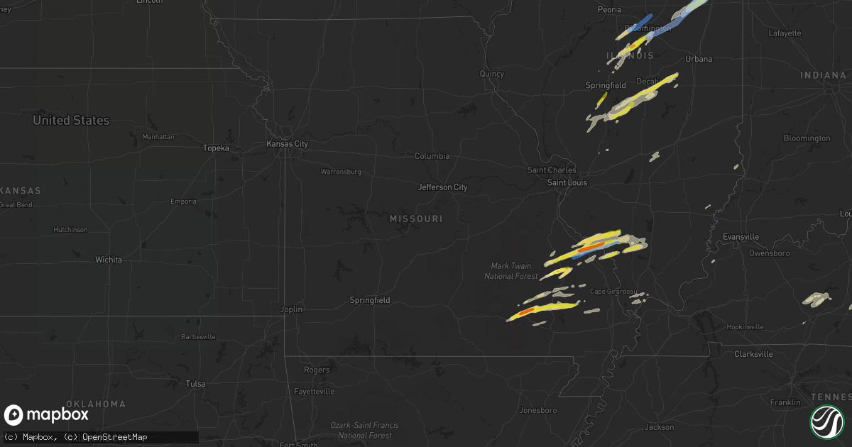
Hail Map in Missouri on April 30, 2022
Get this storm
April 30 map
$229
one time, instant access
Download today. No call, no setup
Keep the $229
Bought the map and want the full workflow? Apply the entire $229 to a subscription within 7 days. None of it is wasted.
Every map, not just this one
This buys you this map. Subscription and you get every map we run, in the markets you choose from a few cities to whole states to nationwide. Plus real-time alerts the moment a storm fires.
Contact data
Name, contact info, occupancy, even credit band for addresses in the footprint. You go from where it hit to who to call.
Become the source they trust
Unlimited branding weather history reports on demand. You already have the documented answer ready for the property owner, and you are the one who showed up with it.
Property data and RoofTrace estimates
Pull up any address you have got, its value and the exact code rules for that jurisdiction, straight from One Click Code. Then RoofTrace estimates the squares, pitch, and roof value, priced the way you price.
Storm reports in Missouri
Missouri
| Date | Description |
|---|---|
| 04/30/20226:10 PM CDT | A local report indicates 1.00 inch wind near GREENVILLE |
| 04/30/20225:36 PM CDT | A local report indicates 1.00 inch wind near PIEDMONT |
| 04/30/20225:20 PM CDT | Report of wind damage with barn leveled... Roof damage to building... Farm equipment damaged... And power lines down. |
| 04/30/20225:12 PM CDT | A local report indicates 60 MPH wind near 3 N PERRYVILLE |
| 04/30/20225:11 PM CDT | Trees and power lines down. Minor damage to buildings. |
| 04/30/20225:11 PM CDT | 25-30 ft pole barn was damaged. Shingles blown off homes. Spotter had observed a funnel cloud in the vicinity of the damage. |
| 04/30/20225:08 PM CDT | A local report indicates 1.50 inch wind near SAINT MARY |
| 04/30/20225:07 PM CDT | Report from mping: quarter |
| 04/30/20225:06 PM CDT | Reported on hh highway near clearwater lake. |
| 04/30/20225:05 PM CDT | A local report indicates 1.00 inch wind near 3 NW LITHIUM |
| 04/30/20225:04 PM CDT | Damage reported to trees and metal roofs. Possible tornado. |
| 04/30/20225:02 PM CDT | A weak tornado briefly touched down within a larger area of straight line winds. |
| 04/30/20224:58 PM CDT | A local report indicates 1.00 inch wind near JUNCTION CITY |
| 04/30/20224:58 PM CDT | A local report indicates 1.00 inch wind near JUNCTION CITY |
| 04/30/20224:55 PM CDT | Estimated 2 to 2.25 hail. Hail was oblong in shape and not spherical. |
| 04/30/20224:53 PM CDT | Reported tree limbs down as well southwest of the airport. |
| 04/30/20224:51 PM CDT | A local report indicates 1.00 inch wind near MINNITH |
| 04/30/20224:45 PM CDT | Golfball size hail observed near junction of us 60 and hwy 21n. |
| 04/30/20224:45 PM CDT | A local report indicates 1.75 inch wind near 2 NNW GARWOOD |
| 04/30/20224:38 PM CDT | 2-3 inch diameter limbs down. Flash flooding occurring on roads. |
| 04/30/20224:34 PM CDT | Estimated 45-50 mph winds. |
| 04/30/20227:48 AM CDT | At 1248 AM CDT, severe thunderstorms were located along a line extending from near Fayette to near Otterville to 8 miles southeast of Warsaw, moving east at 45 mph. HAZARD...60 mph wind gusts and quarter size hail. SOURCE...Radar indicated. IMPACT...Hail damage to vehicles is expected. Expect wind damage to roofs, siding, and trees. Severe thunderstorms will be near... Tipton around 100 AM CDT.Other locations in the path of these severe thunderstorms includeClarksburg, Columbia, California, Hallsville, Sturgeon, Jamestown,McGirk, Murry, Centralia, Centertown, St. Martins, Jefferson City andAshland.This includes Interstate 70 in Missouri between exits 115 and 133. This also includes Rock Bridge State Park, Finger Lakes State Park,and Jewell Cemetery Historic Site. |
| 04/30/20227:22 AM CDT | At 1222 AM CDT, severe thunderstorms were located along a line extending from near Slater to 7 miles east of Houstonia to near Windsor, moving east at 55 mph. HAZARD...60 mph wind gusts. SOURCE...Radar indicated. IMPACT...Expect damage to roofs, siding, and trees. Locations impacted include... Sedalia, Moberly, Marshall, Boonville, Windsor, Fayette, Slater, Salisbury, Huntsville, Glasgow, La Monte, New Franklin, Pilot Grove, Smithton, Higbee, Green Ridge, Keytesville, Otterville, Bunceton and Clark.This includes Interstate 70 in Missouri between mile markers 70 and114. |
| 04/30/20223:11 AM CDT | At 810 PM CDT, a severe thunderstorm was located near Williamsville, or 13 miles west of Lake Wappapello State Park, moving east at 25 mph. HAZARD...60 mph wind gusts and quarter size hail. SOURCE...Radar indicated. IMPACT...Hail damage to vehicles is expected. Expect wind damage to roofs, siding, and trees. This severe thunderstorm will be near... Williamsville around 815 PM CDT. Hendrickson around 825 PM CDT.Other locations in the path of this severe thunderstorm include LakeWappapello State Park, Wappapello and Shook. |
| 04/30/20222:33 AM CDT | At 733 PM CDT, a severe thunderstorm was located over Chester, moving east at 35 mph. HAZARD...60 mph wind gusts and quarter size hail. SOURCE...Radar indicated. IMPACT...Hail damage to vehicles is expected. Expect wind damage to roofs, siding, and trees. This severe thunderstorm will be near... Steeleville and Percy around 750 PM CDT. |
| 04/30/20221:27 AM CDT | At 626 PM CDT, a severe thunderstorm was located 7 miles northeast of Shook, or 11 miles east of Greenville, moving east at 40 mph. HAZARD...70 mph wind gusts and half dollar size hail. SOURCE...Radar indicated. IMPACT...Hail damage to vehicles is expected. Expect considerable tree damage. Wind damage is also likely to mobile homes, roofs, and outbuildings. This severe thunderstorm will be near... Grassy around 640 PM CDT.Other locations in the path of this severe thunderstorm includeLeopold. |
| 04/30/20221:05 AM CDT | At 605 PM CDT, a severe thunderstorm was located near Greenville, moving east at 40 mph. HAZARD...70 mph wind gusts and quarter size hail. SOURCE...Radar indicated. IMPACT...Hail damage to vehicles is expected. Expect considerable tree damage. Wind damage is also likely to mobile homes, roofs, and outbuildings. This severe thunderstorm will be near... Greenville around 610 PM CDT. |
| 04/30/202212:24 AM CDT | At 524 PM CDT, a severe thunderstorm was located 8 miles southeast of Chester, moving east at 30 mph. HAZARD...60 mph wind gusts and quarter size hail. SOURCE...Radar indicated. IMPACT...Hail damage to vehicles is expected. Expect wind damage to roofs, siding, and trees. Locations impacted include... Willisville and Ava. |
| 04/30/202212:09 AM CDT | At 508 PM CDT, a severe thunderstorm was located near Perryville, moving northeast at 40 mph. HAZARD...60 mph wind gusts and quarter size hail. SOURCE...Public. At 501 PM, quarter size hail was reported south of St. Mary. IMPACT...Hail damage to vehicles is expected. Expect wind damage to roofs, siding, and trees. Locations impacted include... Percy. |
| 04/29/202211:57 PM CDT | At 456 PM CDT, a severe thunderstorm was located near Garwood, or 7 miles southwest of Piedmont, moving northeast at 35 mph. HAZARD...Ping pong ball size hail and 60 mph wind gusts. SOURCE...Radar indicated. IMPACT...People and animals outdoors will be injured. Expect hail damage to roofs, siding, windows, and vehicles. Expect wind damage to roofs, siding, and trees. This severe thunderstorm will be near... Piedmont around 510 PM CDT.Other locations in the path of this severe thunderstorm include SamA. Baker State Park and Greenville. |
| 04/29/202211:46 PM CDT | At 445 PM CDT, a severe thunderstorm was located near Roselle, moving northeast at 35 mph. HAZARD...60 mph wind gusts and quarter size hail. SOURCE...Radar indicated. IMPACT...Hail damage to vehicles is expected. Expect wind damage to roofs, siding, and trees. This severe thunderstorm will be near... Fredericktown, Junction City and Cobalt around 500 PM CDT. |
| 04/29/202211:42 PM CDT | At 441 PM CDT, a severe thunderstorm was located over Garwood, moving northeast at 35 mph. HAZARD...60 mph wind gusts and quarter size hail. SOURCE...Public. At 439 PM, quarter size hail was reported in Van Buren. IMPACT...Hail damage to vehicles is expected. Expect wind damage to roofs, siding, and trees. This severe thunderstorm will remain over mainly rural areas of southeastern Reynolds County.This also includes Clearwater Lake Recreational Area. |
| 04/29/202211:30 PM CDT | At 429 PM CDT, a severe thunderstorm was located over Van Buren, moving northeast at 35 mph. HAZARD...60 mph wind gusts and half dollar size hail. SOURCE...Radar indicated. IMPACT...Hail damage to vehicles is expected. Expect wind damage to roofs, siding, and trees. This severe thunderstorm will remain over mainly rural areas of northern Carter County. |
All States Impacted by Hail Map on April 30, 2022
Cities Impacted by Hail Map on April 30, 2022
- Arkadelphia, AR
- Gurdon, AR
- Sparkman, AR
- Farmington, MO
- Chester, IL
- Percy, IL
- Steeleville, IL
- Cutler, IL
- Pinckneyville, IL
- Campbell Hill, IL
- Saint Mary, MO
- Sainte Genevieve, MO
- Perryville, MO
- Rockwood, IL
- Morganfield, KY
- Anderson, TX
- Elkhart, TX
- Oakwood, TX
- Palestine, TX
- Grapeland, TX
- Provencal, LA
- Dubach, LA
- Atlanta, IL
- Lexa, AR
- Marianna, AR
- Buffalo, TX
- Labelle, FL
- Lehigh Acres, FL
- Jacksonville, TX
- Ellsinore, MO
- Van Buren, MO
- Hineston, LA
- Glenmora, LA
- Leesville, LA
- Moweaqua, IL
- Madisonville, TX
- North Zulch, TX
- Normangee, TX
- Monroe, LA
- Griffithville, AR
- Cherry Valley, IL
- Kirkland, IL
- Belvidere, IL
- Fredericktown, MO
- Bedias, TX
- Coupland, TX
- Taylor, TX
- Hutto, TX
- Manor, TX
- Minooka, IL
- Grayson, LA
- Columbia, LA
- Granger, TX
- Pflugerville, TX
- Round Rock, TX
- Columbus, MS
- Waynesville, IL
- Clinton, IL
- Ullin, IL
- Tamms, IL
- Pulaski, IL
- Chipley, FL
- Bonifay, FL
- McLean, IL
- Downs, IL
- Williamsville, IL
- Elkhart, IL
- Heyworth, IL
- Lawndale, IL
- Bloomington, IL
- Shirley, IL
- Lincoln, IL
- Lovington, IL
- Hammond, IL
- Atwood, IL
- Rosston, AR
- Chana, IL
- Davis Junction, IL
- Rochelle, IL
- Des Arc, AR
- Ward, AR
- Carlisle, AR
- Kinsman, IL
- Cornell, IL
- Ransom, IL
- Blackstone, IL
- West Point, MS
- Stonington, IL
- Mansfield, LA
- Du Quoin, IL
- Vergennes, IL
- Elkville, IL
- Doe Run, MO
- Ironton, MO
- Ava, IL
- Macon, IL
- Hampton, AR
- Harrell, AR
- Tupelo, MS
- Belden, MS
- Pontotoc, MS
- Delhi, LA
- Strong, AR
- Junction City, AR
- El Dorado, AR
- Barksdale, TX
- Leakey, TX
- Camp Wood, TX
- Magnolia, AR
- McNeil, AR
- Olmsted, IL
- Villa Ridge, IL
- Mounds, IL
- Carterville, IL
- Hurst, IL
- Murphysboro, IL
- Royalton, IL
- De Soto, IL
- Brownstown, IL
- Palmer, IL
- Taylorville, IL
- Morrisonville, IL
- Hazel Green, WI
- Cuba City, WI
- Platteville, WI
- Rockfield, KY
- Bowling Green, KY
- Ashton, IL
- Holcomb, IL
- Monroe Center, IL
- Garden Prairie, IL
- Rockford, IL
- Milmine, IL
- Dalton City, IL
- Decatur, IL
- Blue Mound, IL
- Cerro Gordo, IL
- Bement, IL
- Argenta, IL
- Mt Zion, IL
- Oxford, MS
- Hermitage, AR
- Jersey, AR
- Chatsworth, IL
- Strawn, IL
- Danforth, IL
- Gilman, IL
- Ashkum, IL
- Forrest, IL
- Piper City, IL
- Steens, MS
- Millport, AL
- Advance, MO
- Marion, LA
- Senatobia, MS
- Tunica, MS
- Sarah, MS
- Dundee, MS
- Iola, TX
- Beatrice, AL
- Jacob, IL
- Houston, MS
- Mantee, MS
- Prairie, MS
- Woodland, MS
- Cedarbluff, MS
- Mountain Home, TX
- Rocksprings, TX
- Hunt, TX
- Brinkley, AR
- Centerville, TX
- Leona, TX
- Marquez, TX
- Brownsville, KY
- Robeline, LA
- Knightstown, IN
- Estero, FL
- Bonita Springs, FL
- Farmersville, IL
- Harvel, IL
- Moro, AR
- Many, LA
- Natchitoches, LA
- Marthaville, LA
- University, MS
- Converse, LA
- Shelbyville, TX
- Greenville, MO
- Parkers Lake, KY
- Batesville, MS
- Abbeville, MS
- Sardis, MS
- Taylor, MS
- Hamilton, MS
- Caledonia, MS
- Ethelsville, AL
- Vernon, AL
- Sulligent, AL
- Poplar Grove, IL
- Lindenwood, IL
- Stillman Valley, IL
- Oregon, IL
- Franklin Grove, IL
- Byron, IL
- Kennedy, AL
- Marquand, MO
- Carrollton, AL
- Gorham, IL
- Frohna, MO
- Marks, MS
- Ruston, LA
- Choudrant, LA
- Park Hills, MO
- Wenona, IL
- Tonica, IL
- Streator, IL
- Auburn, IL
- Lakeland, FL
- Jewett, TX
- Conroe, TX
- Magnolia, TX
- Spring, TX
- Western Springs, IL
- Hinsdale, IL
- Lockport, IL
- Willowbrook, IL
- Woodridge, IL
- Darien, IL
- Lemont, IL
- Jetson, KY
- Sweeden, KY
- Bee Spring, KY
- Roundhill, KY
- Mammoth Cave, KY
- Freeman Spur, IL
- Ellis Grove, IL
- Zeigler, IL
- Mulkeytown, IL
- West Frankfort, IL
- Herrin, IL
- Dowell, IL
- Collinston, LA
- Bastrop, LA
- Montgomery, TX
- Fairbury, IL
- Cropsey, IL
- Colfax, IL
- Ellington, MO
- Eufaula, AL
- Clayton, AL
- Albion, IL
- Saint Elmo, IL
- Vandalia, IL
- Saint Peter, IL
- Waldo, AR
- Del Rio, TX
- North Port, FL
- Biscoe, AR
- Cotton Plant, AR
- Wheatley, AR
- Aubrey, AR
- Lawrenceville, IL
- Navasota, TX
- Mill Spring, MO
- Delavan, IL
- Danvers, IL
- Minier, IL
- Stanford, IL
- Armington, IL
- Hopedale, IL
- La Center, KY
- Prescott, AR
- Aberdeen, MS
- Sterlington, LA
- Kincaid, IL
- Pawnee, IL
- Starkville, MS
- Pleasant Hill, LA
- Browns, IL
- Chidester, AR
- Patterson, MO
- Sarasota, FL
- Camden, AR
- Bearden, AR
- Gordo, AL
- Aliceville, AL
- Brooksville, MS
- Reform, AL
- Plainfield, IL
- Yorkville, IL
- Marseilles, IL
- Grand Ridge, IL
- Rayville, LA
- Mangham, LA
- Troy, AL
- Union Springs, AL
- Mount Holly, AR
- Smackover, AR
- Doerun, GA
- Albany, GA
- La Grange, IL
- La Grange Park, IL
- Romeoville, IL
- Downers Grove, IL
- Silva, MO
- Lodi, MO
- Glenallen, MO
- Clubb, MO
- West Monroe, LA
- Palmyra, IL
- Carlinville, IL
- Girard, IL
- Edinburg, IL
- Waggoner, IL
- Assumption, IL
- New Douglas, IL
- Martin, TN
- Huntsville, TX
- Richards, TX
- Willis, TX
- Morris, IL
- Crockett, TX
- Cabot, AR
- Vilonia, AR
- Montgomery, AL
- Northport, AL
- Groveland, FL
- New Waverly, TX
- Oldsmar, FL
- Palm Harbor, FL
- Oran, MO
- Bell City, MO
- Jackson, AL
- Gipsy, MO
- Fremont, MO
- Piedmont, MO
- Wappapello, MO
- Lowndes, MO
- Zalma, MO
- Berry, AL
- Coldwater, MS
- Eaton Park, FL
- Eros, LA
- Oak Ridge, LA
- Mer Rouge, LA
- Loves Park, IL
- Machesney Park, IL
- Oakdale, LA
- Trinity, TX
- Water Valley, MS
- Calhoun, LA
- Athens, IL
- Greenview, IL
- Middletown, IL
- New Holland, IL
- Zolfo Springs, FL
- Immokalee, FL
- Flat Rock, IL
- Naples, FL
- Grand Chain, IL
- Crystal River, FL
- Lecanto, FL
- Farmerville, LA
- Cave City, KY
- Gladewater, TX
- Winona, TX
- Winnsboro, LA
- Crossett, AR
- Stephens, AR
- Selman City, TX
- Troup, TX
- Overton, TX
- Henderson, TX
- Flanagan, IL
- Carthage, AR
- Thayer, IL
- Chatham, IL
- Glenarm, IL
- Virden, IL
- Patton, MO
- Des Arc, MO
- Poplar Grove, AR
- Marvell, AR
- Thorndale, TX
- Banks, AR
- Spearsville, LA
- Parrish, AL
- Arcadia, MO
- Annapolis, MO
- Lovelady, TX
- Karnak, IL
- Olla, LA
- Kelly, LA
- Holly Grove, AR
- Walshville, IL
- Sorento, IL
- Tampa, FL
- Marble Hill, MO
- Eagle Lake, FL
- Bartow, FL
- Auburndale, FL
- Winter Haven, FL
- Gilbert, LA
- Winnebago, IL
- Caledonia, IL
- Roscoe, IL
- Brooksville, FL
- Friars Point, MS
- Coahoma, MS
- Helena, AR
- Punta Gorda, FL
- Arcadia, FL
- Mazon, IL
- Odell, IL
- Verona, IL
- Dwight, IL
- Horse Cave, KY
- Glasgow, KY
- Homer Glen, IL
- Kilgore, TX
- Grandin, MO
- Frierson, LA
- Coushatta, LA
- Grand Cane, LA
- Pelican, LA
- Ringgold, LA
- Newark, IL
- Etoile, TX
- Genoa, IL
- Kingston, IL
- Como, MS
- Riverside, OR
- Spiceland, IN
- Farrar, MO
- Bonfield, IL
- Wilmington, IL
- Malvern, AR
- Benton, AR
- Morgantown, KY
- Caneyville, KY
- Austin, AR
- West Helena, AR
- Crenshaw, MS
- Sledge, MS
- Clifton, IL
- Sibley, IL
- Placida, FL
- Oak Brook, IL
- Hamburg, AR
- Springfield, IL
- Oswego, IL
- Joliet, IL
- Shorewood, IL
- Towanda, IL
- Lexington, IL
- Hudson, IL
- Normal, IL
- Kempton, IL
- Ellsworth, IL
- Arrowsmith, IL
- Onarga, IL
- Anchor, IL
- Le Roy, IL


