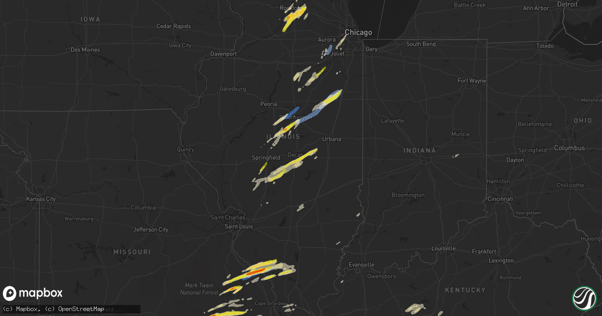
Hail Map on April 30, 2022
Get this storm
April 30 map
$229
one time, instant access
Download today. No call, no setup
Keep the $229
Bought the map and want the full workflow? Apply the entire $229 to a subscription within 7 days. None of it is wasted.
Every map, not just this one
This buys you this map. Subscription and you get every map we run, in the markets you choose from a few cities to whole states to nationwide. Plus real-time alerts the moment a storm fires.
Contact data
Name, contact info, occupancy, even credit band for addresses in the footprint. You go from where it hit to who to call.
Become the source they trust
Unlimited branding weather history reports on demand. You already have the documented answer ready for the property owner, and you are the one who showed up with it.
Property data and RoofTrace estimates
Pull up any address you have got, its value and the exact code rules for that jurisdiction, straight from One Click Code. Then RoofTrace estimates the squares, pitch, and roof value, priced the way you price.
States Impacted by Hail Map on April 30, 2022
Storm reports
Missouri
| Date | Description |
|---|---|
| 04/30/20226:10 PM CDT | A local report indicates 1.00 inch wind near GREENVILLE |
| 04/30/20225:36 PM CDT | A local report indicates 1.00 inch wind near PIEDMONT |
| 04/30/20225:20 PM CDT | Report of wind damage with barn leveled... Roof damage to building... Farm equipment damaged... And power lines down. |
| 04/30/20225:12 PM CDT | A local report indicates 60 MPH wind near 3 N PERRYVILLE |
| 04/30/20225:11 PM CDT | 25-30 ft pole barn was damaged. Shingles blown off homes. Spotter had observed a funnel cloud in the vicinity of the damage. |
| 04/30/20225:11 PM CDT | Trees and power lines down. Minor damage to buildings. |
| 04/30/20225:08 PM CDT | A local report indicates 1.50 inch wind near SAINT MARY |
| 04/30/20225:07 PM CDT | Report from mping: quarter |
| 04/30/20225:06 PM CDT | Reported on hh highway near clearwater lake. |
| 04/30/20225:05 PM CDT | A local report indicates 1.00 inch wind near 3 NW LITHIUM |
| 04/30/20225:04 PM CDT | Damage reported to trees and metal roofs. Possible tornado. |
| 04/30/20225:02 PM CDT | A weak tornado briefly touched down within a larger area of straight line winds. |
| 04/30/20224:58 PM CDT | A local report indicates 1.00 inch wind near JUNCTION CITY |
| 04/30/20224:58 PM CDT | A local report indicates 1.00 inch wind near JUNCTION CITY |
| 04/30/20224:55 PM CDT | Estimated 2 to 2.25 hail. Hail was oblong in shape and not spherical. |
| 04/30/20224:53 PM CDT | Reported tree limbs down as well southwest of the airport. |
| 04/30/20224:51 PM CDT | A local report indicates 1.00 inch wind near MINNITH |
| 04/30/20224:45 PM CDT | Golfball size hail observed near junction of us 60 and hwy 21n. |
| 04/30/20224:45 PM CDT | A local report indicates 1.75 inch wind near 2 NNW GARWOOD |
| 04/30/20224:38 PM CDT | 2-3 inch diameter limbs down. Flash flooding occurring on roads. |
| 04/30/20224:34 PM CDT | Estimated 45-50 mph winds. |
| 04/30/20227:48 AM CDT | At 1248 AM CDT, severe thunderstorms were located along a line extending from near Fayette to near Otterville to 8 miles southeast of Warsaw, moving east at 45 mph. HAZARD...60 mph wind gusts and quarter size hail. SOURCE...Radar indicated. IMPACT...Hail damage to vehicles is expected. Expect wind damage to roofs, siding, and trees. Severe thunderstorms will be near... Tipton around 100 AM CDT.Other locations in the path of these severe thunderstorms includeClarksburg, Columbia, California, Hallsville, Sturgeon, Jamestown,McGirk, Murry, Centralia, Centertown, St. Martins, Jefferson City andAshland.This includes Interstate 70 in Missouri between exits 115 and 133. This also includes Rock Bridge State Park, Finger Lakes State Park,and Jewell Cemetery Historic Site. |
| 04/30/20227:22 AM CDT | At 1222 AM CDT, severe thunderstorms were located along a line extending from near Slater to 7 miles east of Houstonia to near Windsor, moving east at 55 mph. HAZARD...60 mph wind gusts. SOURCE...Radar indicated. IMPACT...Expect damage to roofs, siding, and trees. Locations impacted include... Sedalia, Moberly, Marshall, Boonville, Windsor, Fayette, Slater, Salisbury, Huntsville, Glasgow, La Monte, New Franklin, Pilot Grove, Smithton, Higbee, Green Ridge, Keytesville, Otterville, Bunceton and Clark.This includes Interstate 70 in Missouri between mile markers 70 and114. |
| 04/30/20223:11 AM CDT | At 810 PM CDT, a severe thunderstorm was located near Williamsville, or 13 miles west of Lake Wappapello State Park, moving east at 25 mph. HAZARD...60 mph wind gusts and quarter size hail. SOURCE...Radar indicated. IMPACT...Hail damage to vehicles is expected. Expect wind damage to roofs, siding, and trees. This severe thunderstorm will be near... Williamsville around 815 PM CDT. Hendrickson around 825 PM CDT.Other locations in the path of this severe thunderstorm include LakeWappapello State Park, Wappapello and Shook. |
| 04/30/20222:33 AM CDT | At 733 PM CDT, a severe thunderstorm was located over Chester, moving east at 35 mph. HAZARD...60 mph wind gusts and quarter size hail. SOURCE...Radar indicated. IMPACT...Hail damage to vehicles is expected. Expect wind damage to roofs, siding, and trees. This severe thunderstorm will be near... Steeleville and Percy around 750 PM CDT. |
| 04/30/20221:27 AM CDT | At 626 PM CDT, a severe thunderstorm was located 7 miles northeast of Shook, or 11 miles east of Greenville, moving east at 40 mph. HAZARD...70 mph wind gusts and half dollar size hail. SOURCE...Radar indicated. IMPACT...Hail damage to vehicles is expected. Expect considerable tree damage. Wind damage is also likely to mobile homes, roofs, and outbuildings. This severe thunderstorm will be near... Grassy around 640 PM CDT.Other locations in the path of this severe thunderstorm includeLeopold. |
| 04/30/20221:05 AM CDT | At 605 PM CDT, a severe thunderstorm was located near Greenville, moving east at 40 mph. HAZARD...70 mph wind gusts and quarter size hail. SOURCE...Radar indicated. IMPACT...Hail damage to vehicles is expected. Expect considerable tree damage. Wind damage is also likely to mobile homes, roofs, and outbuildings. This severe thunderstorm will be near... Greenville around 610 PM CDT. |
| 04/30/202212:24 AM CDT | At 524 PM CDT, a severe thunderstorm was located 8 miles southeast of Chester, moving east at 30 mph. HAZARD...60 mph wind gusts and quarter size hail. SOURCE...Radar indicated. IMPACT...Hail damage to vehicles is expected. Expect wind damage to roofs, siding, and trees. Locations impacted include... Willisville and Ava. |
| 04/30/202212:09 AM CDT | At 508 PM CDT, a severe thunderstorm was located near Perryville, moving northeast at 40 mph. HAZARD...60 mph wind gusts and quarter size hail. SOURCE...Public. At 501 PM, quarter size hail was reported south of St. Mary. IMPACT...Hail damage to vehicles is expected. Expect wind damage to roofs, siding, and trees. Locations impacted include... Percy. |
| 04/29/202211:57 PM CDT | At 456 PM CDT, a severe thunderstorm was located near Garwood, or 7 miles southwest of Piedmont, moving northeast at 35 mph. HAZARD...Ping pong ball size hail and 60 mph wind gusts. SOURCE...Radar indicated. IMPACT...People and animals outdoors will be injured. Expect hail damage to roofs, siding, windows, and vehicles. Expect wind damage to roofs, siding, and trees. This severe thunderstorm will be near... Piedmont around 510 PM CDT.Other locations in the path of this severe thunderstorm include SamA. Baker State Park and Greenville. |
| 04/29/202211:46 PM CDT | At 445 PM CDT, a severe thunderstorm was located near Roselle, moving northeast at 35 mph. HAZARD...60 mph wind gusts and quarter size hail. SOURCE...Radar indicated. IMPACT...Hail damage to vehicles is expected. Expect wind damage to roofs, siding, and trees. This severe thunderstorm will be near... Fredericktown, Junction City and Cobalt around 500 PM CDT. |
| 04/29/202211:42 PM CDT | At 441 PM CDT, a severe thunderstorm was located over Garwood, moving northeast at 35 mph. HAZARD...60 mph wind gusts and quarter size hail. SOURCE...Public. At 439 PM, quarter size hail was reported in Van Buren. IMPACT...Hail damage to vehicles is expected. Expect wind damage to roofs, siding, and trees. This severe thunderstorm will remain over mainly rural areas of southeastern Reynolds County.This also includes Clearwater Lake Recreational Area. |
| 04/29/202211:30 PM CDT | At 429 PM CDT, a severe thunderstorm was located over Van Buren, moving northeast at 35 mph. HAZARD...60 mph wind gusts and half dollar size hail. SOURCE...Radar indicated. IMPACT...Hail damage to vehicles is expected. Expect wind damage to roofs, siding, and trees. This severe thunderstorm will remain over mainly rural areas of northern Carter County. |
Louisiana
| Date | Description |
|---|---|
| 04/30/20226:25 AM CDT | At 1124 PM CDT, a severe thunderstorm was located 10 miles north of Ruston, moving east at 20 mph. HAZARD...60 mph wind gusts and quarter size hail. SOURCE...Radar indicated. IMPACT...Hail damage to vehicles is expected. Expect wind damage to roofs, siding, and trees. Locations impacted include... Dubach, Choudrant, Vienna, Downsville, D Arbonne, Calhoun, Mineral Springs, Mount Zion, Unionville, Eureka and Folksville. |
| 04/30/20226:24 AM CDT | At 1123 PM CDT, severe thunderstorms were located along a line extending from near Crossett to 10 miles northwest of Sterlington, moving southeast at 20 mph. HAZARD...60 mph wind gusts and quarter size hail. SOURCE...Radar indicated. IMPACT...Hail damage to vehicles is expected. Expect wind damage to roofs, siding, and trees. Locations impacted include... Bastrop, Wilmot, Jones, Berlin, Beekman, Galion and Bonita. |
| 04/30/20226:20 AM CDT | At 1119 PM CDT, a severe thunderstorm was located 11 miles northeast of Mansfield, moving east at 15 mph. HAZARD...60 mph wind gusts and quarter size hail. SOURCE...Radar indicated. IMPACT...Hail damage to vehicles is expected. Expect wind damage to roofs, siding, and trees. Locations impacted include... Mansfield, Coushatta, Martin, Hall Summit, Ashland, Edgefield, Carmel, Lake End, Evelyn, Grand Bayou, Hanna, Loggy Bayou, Womack, Crichton, Rambin and Armistead. |
| 04/29/202211:32 PM CDT | A tree was downed on highway 151 west of highway 33 near the union/lincoln parish line. |
Oklahoma
| Date | Description |
|---|---|
| 04/30/20227:59 AM CDT | At 1259 AM CDT, severe thunderstorms were located along a line extending from Oilton to 2 miles south of Avery, moving southeast at 35 mph. HAZARD...60 mph wind gusts and half dollar size hail. SOURCE...Radar indicated. IMPACT...Hail damage to vehicles is expected. Expect wind damage to roofs, siding, and trees. Locations in or near the path include... Bristow... Sapulpa... Drumright... Kellyville... Oilton... Depew... Shamrock... Silver City... Milfay... This includes Interstate 44 between mile markers 178 and 213. |
| 04/30/20227:58 AM CDT | At 1257 AM CDT, a severe thunderstorm was located near Avery, moving east at 50 mph. HAZARD...60 mph wind gusts and quarter size hail. SOURCE...Radar indicated. IMPACT...Hail damage to vehicles is expected. Expect wind damage to roofs, siding, and trees. Locations impacted include... Cushing, Chandler, Stroud, Davenport, Agra, Kendrick, Avery and Parkland. |
| 04/30/20227:23 AM CDT | At 1223 AM CDT, a severe thunderstorm was located 6 miles northwest of Ripley, moving east at 45 mph. HAZARD...60 mph wind gusts and quarter size hail. SOURCE...Trained weather spotters. IMPACT...Hail damage to vehicles is expected. Expect wind damage to roofs, siding, and trees. Locations impacted include... Stillwater, Cushing, Perkins, Yale, Glencoe, Ripley, Quay and Ingalls. |
| 04/30/202212:59 AM CDT | At 558 AM CDT, a severe thunderstorm was located near Wilburton, moving east at 25 mph. HAZARD...60 mph wind gusts and quarter size hail. SOURCE...Radar indicated. IMPACT...Hail damage to vehicles is expected. Expect wind damage to roofs, siding, and trees. Locations in or near the path include... Wilburton... Red Oak... Fanshawe... Bengal... Panola... Summerfield... |
| 04/29/202211:53 PM CDT | At 453 AM CDT, severe thunderstorms were located along a line extending from 3 miles southeast of Blocker to Krebs, moving east at 30 mph. HAZARD...60 mph wind gusts and quarter size hail. SOURCE...Radar indicated. IMPACT...Hail damage to vehicles is expected. Expect wind damage to roofs, siding, and trees. Locations in or near the path include... Mcalester... Wilburton... Hartshorne... Krebs... Alderson... Higgins... Damon... Robbers Cave State Park... Haileyville... Gowen... Panola... Dow... Bache... |
| 04/29/202210:46 PM CDT | At 346 AM CDT, a severe thunderstorm was located 4 miles southwest of Indianola, moving east at 30 mph. HAZARD...60 mph wind gusts and quarter size hail. SOURCE...Radar indicated. IMPACT...Hail damage to vehicles is expected. Expect wind damage to roofs, siding, and trees. Locations in or near the path include... Eufaula... Crowder... Canadian... Indianola... Hanna... Arrowhead State Park... Featherston... |
| 04/29/20229:33 PM CDT | At 233 AM CDT, a severe thunderstorm was located 5 miles west of Wetumka, moving east at 35 mph. HAZARD...60 mph wind gusts and quarter size hail. SOURCE...Radar indicated. IMPACT...Hail damage to vehicles is expected. Expect wind damage to roofs, siding, and trees. Locations impacted include... Wetumka, Dustin and Yeager. |
| 04/29/20229:00 PM CDT | At 200 AM CDT, a severe thunderstorm was located 5 miles south of Paden, moving east at 40 mph. HAZARD...60 mph wind gusts and quarter size hail. SOURCE...Radar indicated. IMPACT...Hail damage to vehicles is expected. Expect wind damage to roofs, siding, and trees. Locations impacted include... Cromwell and Little. |
| 04/29/20228:45 PM CDT | At 145 AM CDT, severe thunderstorms were located along a line extending from 4 miles northeast of Sand Springs to 3 miles south of Kellyville, moving east at 40 mph. HAZARD...60 mph wind gusts and quarter size hail. SOURCE...Radar indicated. IMPACT...Hail damage to vehicles is expected. Expect wind damage to roofs, siding, and trees. Locations in or near the path include... Tulsa... Broken Arrow... Sand Springs... Bixby... Sapulpa... Jenks... Glenpool... Coweta... Catoosa... Haskell... Inola... Kiefer... Mounds... Kellyville... Jenks Riverside Airport... Stonebluff... Bald Hill... Turley... Tulsa International Airport... Oneta...This includes Interstate 44 between mile markers 203 and 242. |
| 04/29/20228:30 PM CDT | At 130 AM CDT, severe thunderstorms were located along a line extending from 3 miles north of Bristow to 4 miles east of Sparks, moving southeast at 35 mph. HAZARD...60 mph wind gusts and half dollar size hail. SOURCE...Radar indicated. IMPACT...Hail damage to vehicles is expected. Expect wind damage to roofs, siding, and trees. Locations in or near the path include... Okmulgee... Bristow... Okemah... Okfuskee... Beggs... Boley... Depew... Paden... Bearden... Slick... Castle... Clearview... Preston... Okmulgee State Park... Welty... Milfay... Mason... This includes the following highways, Interstate 40 in Oklahoma between mile markers 212 and 229. Interstate 44 between mile markers 178 and 198. |
| 04/29/20228:23 PM CDT | At 123 AM CDT, a severe thunderstorm was located near Sparks, moving east at 40 mph. HAZARD...Ping pong ball size hail and 60 mph wind gusts. SOURCE...Radar indicated. IMPACT...People and animals outdoors will be injured. Expect hail damage to roofs, siding, windows, and vehicles. Expect wind damage to roofs, siding, and trees. Locations impacted include... Prague, Meeker, Davenport and Sparks. |
Mississippi
| Date | Description |
|---|---|
| 04/30/20225:14 AM CDT | At 1014 PM CDT, a severe thunderstorm was located over Little Texas, or 17 miles west of Senatobia, moving east at 25 mph. HAZARD...60 mph wind gusts and quarter size hail. SOURCE...Radar indicated. IMPACT...Hail damage to vehicles is expected. Expect wind damage to roofs, siding, and trees. Locations impacted include... Hernando, Senatobia, Coldwater, Arkabutla, Phillipp, Strayhorn, Little Texas, Eudora, Robinson Gin, Trinity, Dooley, Savage, Frees Corners, Crossroad, Hollywood, Lost Lake, Prichard, Sarah, Love and Poagville. |
| 04/30/20224:53 AM CDT | At 953 PM CDT, a severe thunderstorm was located 8 miles south of Brickeys, or 8 miles east of Marianna, moving east at 25 mph. HAZARD...60 mph wind gusts and quarter size hail. SOURCE...Radar indicated. IMPACT...Hail damage to vehicles is expected. Expect wind damage to roofs, siding, and trees. Locations impacted include... Hughes, Helena-West Helena, St Francis National Park, Tunica, Dubbs, Brickeys, North Tunica, Little Texas, Jeffersonville, Cody, Kokomo, Haleside, Commerce, Austin, Mud Lake, Soudan, Peters, Council, North Hughes and Diamond Woods. |
| 04/30/20224:24 AM CDT | At 924 PM CDT, a severe thunderstorm was located near Rondo, or near Marianna, moving east at 25 mph. HAZARD...60 mph wind gusts and quarter size hail. SOURCE...Radar indicated. IMPACT...Hail damage to vehicles is expected. Expect wind damage to roofs, siding, and trees. Locations impacted include... Marianna, Lexa, Moro, Rondo, Aubrey, Haynes, Brickeys, Lagrange, Jeffersonville, Cody, Oak Forest, Westor, Haleside, Soudan, Turkey Scratch, Vineyard, Heustess, Ball Point, Cypress Corner and Tongin. |
| 04/30/20223:41 AM CDT | At 840 PM CDT, a severe thunderstorm was located near Garret Grove, or 7 miles east of Brinkley, moving east at 30 mph. HAZARD...60 mph wind gusts and quarter size hail. SOURCE...Radar indicated. IMPACT...Hail damage to vehicles is expected. Expect wind damage to roofs, siding, and trees. Locations impacted include... Forrest City, Marianna, Madison, Palestine, Wheatley, Moro, Haynes, Garret Grove, New Salem, Brickeys, New Home, Cody, Kokomo, Oak Forest, Westor, Soudan, Goodwin, Heustess, Ball Point and Whitehall. |
| 04/29/202210:20 PM CDT | Hail report from 1 n strayhorn. |
| 04/29/202210:15 PM CDT | Numerous trees down in near the savage community. |
Texas
| Date | Description |
|---|---|
| 04/30/20226:36 PM CDT | A local report indicates 1.25 inch wind near 7 SW PALESTINE |
| 04/30/20225:58 PM CDT | Report from mping: quarter |
| 04/30/20225:15 PM CDT | Lots of dime to quarter sized hail reported from the brushy creek rv park. Delayed report... Time estimated by radar. |
| 04/30/20224:50 PM CDT | A local report indicates 1.25 inch wind near HUTTO |
| 04/30/20224:48 PM CDT | Report from mping: golf ball |
| 04/30/20224:32 PM CDT | Report from mping: half dollar |
| 04/30/20225:20 AM CDT | At 1020 PM CDT, a severe thunderstorm was located 10 miles north of Montgomery, or 13 miles southwest of Huntsville, moving south at 20 mph. HAZARD...60 mph wind gusts and quarter size hail. SOURCE...Radar indicated. IMPACT...Hail damage to vehicles is expected. Expect wind damage to roofs, siding, and trees. Locations impacted include... Northwestern Conroe, Willis, Panorama Village, Montgomery and Lake Conroe Dam. |
| 04/30/20225:09 AM CDT | At 1009 PM CDT, a severe thunderstorm was located 8 miles southwest of Huntsville, moving southeast at 25 mph. HAZARD...Quarter size hail. SOURCE...Radar indicated. IMPACT...Damage to vehicles is expected. Locations impacted include... Huntsville, New Waverly and Huntsville State Park. |
| 04/30/20224:30 AM CDT | At 930 PM CDT, severe thunderstorms were located along a line extending from near Loma Alta to 11 miles northeast of Carta Valley, moving east at 10 mph. HAZARD...Quarter size hail. SOURCE...Radar indicated. IMPACT...Damage to vehicles is expected. Locations impacted include... Loma Alta, Vinegarone and Devils River State Nat Area Del Norte. |
| 04/30/20224:25 AM CDT | At 925 PM CDT, severe thunderstorms were located along a line extending from 7 miles east of Kurten to 8 miles southeast of Bedias to 6 miles north of Huntsville to Trinity, moving southeast at 20 mph. HAZARD...Quarter size hail. SOURCE...Radar indicated. IMPACT...Damage to vehicles is expected. Locations impacted include... Huntsville, Trinity, Onalaska, New Waverly, Point Blank, Riverside, Bedias, Sebastopol, Huntsville State Park, Iola, Crabbs Prairie and Oakhurst. |
| 04/30/20224:00 AM CDT | At 859 PM CDT, severe thunderstorms were located along a line extending from 10 miles west of Riverside to 6 miles northeast of Bedias to 10 miles east of Kurten, moving southeast at 15 mph. HAZARD...Quarter size hail. SOURCE...Radar indicated. IMPACT...Damage to vehicles is expected. Locations impacted include... Huntsville, Madisonville, Point Blank, Riverside, Bedias, Kurten, Iola, Crabbs Prairie and Oakhurst. |
| 04/30/20223:13 AM CDT | At 813 PM CDT, severe thunderstorms were located along a line extending from 15 miles northeast of Kurten to near Madisonville, moving southeast at 10 mph. HAZARD...60 mph wind gusts and quarter size hail. SOURCE...Radar indicated. IMPACT...Hail damage to vehicles is expected. Expect wind damage to roofs, siding, and trees. Locations impacted include... Madisonville and North Zulch. |
| 04/30/20223:08 AM CDT | At 808 PM CDT, a severe thunderstorm was located 16 miles north of Tuff, or 19 miles north of Leakey, moving northeast at 10 mph. HAZARD...Ping pong ball size hail and 60 mph wind gusts. SOURCE...Radar indicated. IMPACT...People and animals outdoors will be injured. Expect hail damage to roofs, siding, windows, and vehicles. Expect wind damage to roofs, siding, and trees. Locations impacted include... Kerr Wildlife Management Area and Prade Ranch. |
| 04/30/20222:58 AM CDT | At 758 PM CDT, a severe thunderstorm was located near Ponta, or 7 miles east of Jacksonville, moving southeast at 15 mph. HAZARD...60 mph wind gusts and quarter size hail. SOURCE...Radar indicated. IMPACT...Hail damage to vehicles is expected. Expect wind damage to roofs, siding, and trees. Locations impacted include... Jacksonville, Rusk, Sacul, New Salem, Ponta, New Summerfield, Gallatin, Reklaw and Laneville. |
| 04/30/20222:53 AM CDT | At 753 PM CDT, severe thunderstorms were located along a line extending from 9 miles southwest of Grapeland to 6 miles west of Crockett, moving east at 10 mph. HAZARD...Quarter size hail. SOURCE...Radar indicated. IMPACT...Damage to vehicles is expected. Locations impacted include... Crockett, Grapeland and Latexo. |
| 04/30/20222:48 AM CDT | At 748 PM CDT, a severe thunderstorm was located near Conroe, moving east at 10 mph. HAZARD...Quarter size hail. SOURCE...Radar indicated. IMPACT...Damage to vehicles is expected. Locations impacted include... Conroe, The Woodlands, Oak Ridge North, Shenandoah, Cut And Shoot, Woodloch, The Woodlands Pavillion, Porter Heights and Chateau Woods. |
| 04/30/20222:30 AM CDT | At 729 PM CDT, a severe thunderstorm was located over Barksdale, or 16 miles west of Leakey, and is nearly stationary. HAZARD...60 mph wind gusts and quarter size hail. SOURCE...Radar indicated. IMPACT...Hail damage to vehicles is expected. Expect wind damage to roofs, siding, and trees. Locations impacted include... Camp Wood and Barksdale. |
| 04/30/20222:28 AM CDT | At 727 PM CDT, a severe thunderstorm was located 8 miles northwest of Madisonville, moving east at 20 mph. HAZARD...60 mph wind gusts and half dollar size hail. SOURCE...Radar indicated. IMPACT...Hail damage to vehicles is expected. Expect wind damage to roofs, siding, and trees. Locations impacted include... Madisonville. |
| 04/30/20222:26 AM CDT | At 726 PM CDT, a severe thunderstorm was located 10 miles northeast of Vance, or 17 miles northwest of Leakey, moving northeast at 20 mph. HAZARD...Golf ball size hail and 60 mph wind gusts. SOURCE...Radar indicated. IMPACT...People and animals outdoors will be injured. Expect hail damage to roofs, siding, windows, and vehicles. Expect wind damage to roofs, siding, and trees. This severe thunderstorm will remain over mainly rural areas of west central Kerr, northeastern Edwards and northwestern Real Counties. |
| 04/30/20222:14 AM CDT | At 713 PM CDT, a severe thunderstorm was located 10 miles northwest of Madisonville, moving east at 20 mph. HAZARD...Quarter size hail. SOURCE...Radar indicated. IMPACT...Damage to vehicles is expected. Locations impacted include... Madisonville and Normangee. |
| 04/30/20222:13 AM CDT | At 713 PM CDT, a severe thunderstorm was located near Tuff, or 9 miles north of Leakey, moving northeast at 5 mph. HAZARD...60 mph wind gusts and quarter size hail. SOURCE...Radar indicated. IMPACT...Hail damage to vehicles is expected. Expect wind damage to roofs, siding, and trees. Locations impacted include... Lost Maples State Natural Area, Tuff and Prade Ranch. |
| 04/30/20222:01 AM CDT | At 701 PM CDT, a severe thunderstorm was located near Grapeland, or 14 miles northwest of Crockett, moving east at 30 mph. HAZARD...Quarter size hail. SOURCE...Radar indicated. IMPACT...Damage to vehicles is expected. Locations impacted include... Crockett, Grapeland and Latexo. |
| 04/30/20222:01 AM CDT | At 700 PM CDT, a severe thunderstorm was located over Mixon, or near Jacksonville, moving east at 15 mph. HAZARD...60 mph wind gusts and quarter size hail. SOURCE...Radar indicated. IMPACT...Hail damage to vehicles is expected. Expect wind damage to roofs, siding, and trees. Locations impacted include... Jacksonville, Mount Selman, Mixon, New Salem, Ponta, New Summerfield, Gallatin, Reklaw and Concord. |
| 04/30/20221:57 AM CDT | At 657 PM CDT, a severe thunderstorm was located 13 miles west of Elkhart, or 15 miles southwest of Palestine, moving east at 10 mph. HAZARD...Quarter size hail. SOURCE...Radar indicated. IMPACT...Damage to vehicles is possible. This severe thunderstorm will remain over mainly rural areas of northeastern Leon and south central Anderson Counties. |
| 04/30/20221:55 AM CDT | At 655 PM CDT, a severe thunderstorm was located over Turnertown, or 9 miles west of Henderson, moving east at 10 mph. HAZARD...60 mph wind gusts and half dollar size hail. SOURCE...Radar indicated. IMPACT...Hail damage to vehicles is expected. Expect wind damage to roofs, siding, and trees. Locations impacted include... Henderson, Overton, New London, Turnertown, Joinerville, Oak Hill and Brachfield. |
| 04/30/20221:31 AM CDT | At 630 PM CDT, a pair of severe thunderstorms were located along a line extending from near Centerville to 20 miles northeast of Franklin, moving east at 10 mph. HAZARD...Quarter size hail. SOURCE...Radar indicated. IMPACT...Damage to vehicles is possible. Locations impacted include... Centerville and Leona. This includes Interstate 45 between mile markers 152 and 168. |
| 04/30/20221:27 AM CDT | At 626 PM CDT, a severe thunderstorm was located 7 miles northwest of Barksdale, or 16 miles south of Rocksprings, moving northeast at 15 mph. HAZARD...Golf ball size hail and 60 mph wind gusts. SOURCE...Radar indicated. IMPACT...People and animals outdoors will be injured. Expect hail damage to roofs, siding, windows, and vehicles. Expect wind damage to roofs, siding, and trees. Locations impacted include... Vance, Barksdale, Devil's Sinkhole State Natural Area and Prade Ranch. |
| 04/30/202212:48 AM CDT | At 548 PM CDT, a severe thunderstorm was located near Palestine, moving southeast at 10 mph. HAZARD...60 mph wind gusts and quarter size hail. SOURCE...Radar indicated. IMPACT...Hail damage to vehicles is expected. Expect wind damage to roofs, siding, and trees. Locations impacted include... Palestine and Elkhart. |
| 04/30/202212:08 AM CDT | At 507 PM CDT, a severe thunderstorm was located near Coupland, or near Pflugerville, moving east at 15 mph. HAZARD...60 mph wind gusts and half dollar size hail. SOURCE...Radar indicated. IMPACT...Hail damage to vehicles is expected. Expect wind damage to roofs, siding, and trees. Locations impacted include... Pflugerville, Elgin, Hutto, Coupland, Rices Crossing, Beyarsville, McDade and Butler. |
| 04/29/202211:37 PM CDT | At 436 PM CDT, a severe thunderstorm was located over Hutto, or near Pflugerville, moving east at 15 mph. HAZARD...Quarter size hail. SOURCE...Trained weather spotters. IMPACT...Damage to vehicles is expected. Locations impacted include... Round Rock, Taylor, Hutto, Coupland, Rices Crossing, Noack and Beyarsville. |
| 04/29/20228:45 PM CDT | Golf to ping-pong ball sized hail near madisonville |
| 04/29/20227:50 PM CDT | Ping-pongball sized hail near madisonville |
| 04/29/20227:10 PM CDT | Social media photo. |
| 04/29/20227:00 PM CDT | A local report indicates 1.00 inch wind near 1 E LEONA |
Kentucky
| Date | Description |
|---|---|
| 04/30/20221:55 AM CDT | Hart county dispatch reports trees down along the 9700 block of raider hollow rd. |
Oregon
| Date | Description |
|---|---|
| 04/30/202212:42 AM CDT | At 541 PM MDT, a severe thunderstorm was located near Malloy Ranch, or 37 miles southwest of Nampa, moving east at 25 mph. HAZARD...60 mph wind gusts and quarter size hail. SOURCE...Radar indicated. IMPACT...Hail damage to vehicles is expected. Expect wind damage to roofs, siding, and trees. This severe thunderstorm will be near... Succor Creek Reservoir around 550 PM MDT. Squaw Butte around 600 PM MDT. Reynolds around 620 PM MDT. |
| 04/30/202212:41 AM CDT | At 541 PM MDT, a severe thunderstorm was located 7 miles northeast of Rome Airport, or 15 miles southwest of Rome, moving east at 30 mph. HAZARD...60 mph wind gusts and quarter size hail. SOURCE...Radar indicated. IMPACT...Hail damage to vehicles is expected. Expect wind damage to roofs, siding, and trees. This severe thunderstorm will be near... Jackies Butte around 600 PM MDT. Scott Reservoir around 610 PM MDT. Mustang Butte around 620 PM MDT. Grassy Mountain around 630 PM MDT. Mouse Trap Butte around 640 PM MDT. |
| 04/29/202211:53 PM CDT | At 453 PM MDT, a severe thunderstorm was located over Birch Creek Campground, or 26 miles north of Rome, moving east at 30 mph. HAZARD...60 mph wind gusts and quarter size hail. SOURCE...Radar indicated. IMPACT...Hail damage to vehicles is expected. Expect wind damage to roofs, siding, and trees. This severe thunderstorm will be near... Slocum Creek Campground around 510 PM MDT. Mahogany Mountain and Leslie Gulch around 520 PM MDT. Rockville School and southern Owyhee Reservoir around 530 PM MDT. Malloy Ranch around 540 PM MDT. |
| 04/29/20228:15 PM CDT | Received a video of what appears to be a brief gustnado that formed near the edge of a nearby strong shower and caused some damage to a baseball field located at cook p |
Arkansas
| Date | Description |
|---|---|
| 04/30/20226:52 PM CDT | A video posted to social media showed either a brief... Weak tornado or gustnado south of des arc. There was apparent minor damage to some outbuildings at skarda farms. |
| 04/30/20226:14 PM CDT | A tornado was reported at tull... Blowing trees down. The tornado was reported to be very small and weak... And apparently brief. |
| 04/30/20226:08 PM CDT | A local report indicates 1.50 inch wind near 1 N HICKORY PLAINS |
| 04/30/20225:50 PM CDT | A tree was blown down across highway 38. |
| 04/30/20225:19 PM CDT | Nickel to quarter sized hail was reported in greystone near cabot. Report relayed by broadcast media |
| 04/30/20226:17 AM CDT | At 1117 PM CDT, a severe thunderstorm was located 11 miles south of Huttig, moving southeast at 30 mph. HAZARD...60 mph wind gusts and quarter size hail. SOURCE...Radar indicated. IMPACT...Hail damage to vehicles is expected. Expect wind damage to roofs, siding, and trees. Locations impacted include... Marion, Cecil, Spencer, Linville, Haile and Litroe. |
| 04/30/20225:13 AM CDT | At 1012 PM CDT, a severe thunderstorm was located near Urbana, or 9 miles southeast of El Dorado, moving east at 25 mph. HAZARD...60 mph wind gusts and half dollar size hail. SOURCE...Radar indicated. IMPACT...Hail damage to vehicles is expected. Expect wind damage to roofs, siding, and trees. Locations impacted include... El Dorado, Huttig, Strong, Lapile, Urbana, Lawson, Felsenthal, Hillsboro, Lockhart, New London, Aurelle and Pigeon Hill. |
| 04/30/20225:05 AM CDT | At 1005 PM CDT, a severe thunderstorm was located 7 miles southeast of Ingalls, or 10 miles north of West Crossett, moving southeast at 20 mph. HAZARD...60 mph wind gusts and half dollar size hail. SOURCE...Radar indicated. IMPACT...Hail damage to vehicles is expected. Expect wind damage to roofs, siding, and trees. Locations impacted include... Crossett, Hamburg, North Crossett, West Crossett, Fountain Hill, Old Milo and Blanchton. |
| 04/30/20224:56 AM CDT | At 955 PM CDT, a severe thunderstorm was located near Ingalls, or 15 miles north of West Crossett, moving east at 15 mph. HAZARD...Quarter size hail. SOURCE...Radar indicated. IMPACT...Damage to vehicles is expected. Locations impacted include... Hermitage... Ingalls... Ladelle... Prairie Grove... Vick... Valley... Mt Olive in Bradley County... Johnsonville... Sumpter... Lacey... |
| 04/30/20224:13 AM CDT | At 913 PM CDT, a severe thunderstorm was located near Tunica, or 8 miles northeast of St Francis National Park, moving east at 25 mph. HAZARD...60 mph wind gusts and quarter size hail. SOURCE...Radar indicated. IMPACT...Hail damage to vehicles is expected. Expect wind damage to roofs, siding, and trees. Locations impacted include... Tunica, North Tunica, Dubbs, Little Texas, Dooley, Savage, Maud, Fox Island, Austin, Clayton, Hollywood, Prichard and Evansville. |
| 04/30/20224:04 AM CDT | At 904 PM CDT, a severe thunderstorm was located near Wesson, or 9 miles northwest of Junction City, moving east at 25 mph. HAZARD...60 mph wind gusts and half dollar size hail. SOURCE...Radar indicated. IMPACT...Hail damage to vehicles is expected. Expect wind damage to roofs, siding, and trees. Locations impacted include... El Dorado, Smackover, Norphlet, Junction City, Strong, Calion, Mount Holly, Atlanta, Wesson, Village, Lisbon, Urbana, Lawson, Lapile, Newell, New London, Pigeon Hill, Kenova, Spotville and Medlock. |
| 04/30/20223:08 AM CDT | At 807 PM CDT, a severe thunderstorm was located over Stephens, or 9 miles northeast of McNeil, moving east at 15 mph. HAZARD...60 mph wind gusts and quarter size hail. SOURCE...Radar indicated. IMPACT...Hail damage to vehicles is expected. Expect wind damage to roofs, siding, and trees. Locations impacted include... Stephens... |
| 04/30/20223:00 AM CDT | At 759 PM CDT, a severe thunderstorm was located 7 miles southeast of Harlow, or 7 miles north of Hampton, moving east at 20 mph. HAZARD...60 mph wind gusts and quarter size hail. SOURCE...Radar indicated. IMPACT...Hail damage to vehicles is expected. Expect wind damage to roofs, siding, and trees. Locations impacted include... Marks Mill State Park... Weeks... Ellisville... Banks... Tinsman... Woodberry... New Edinburg... |
| 04/30/20222:27 AM CDT | At 727 PM CDT, a severe thunderstorm was located near Fredonia, or 7 miles northeast of De Valls Bluff, moving east at 30 mph. HAZARD...60 mph wind gusts and quarter size hail. SOURCE...Radar indicated. IMPACT...Hail damage to vehicles is expected. Expect wind damage to roofs, siding, and trees. Locations impacted include... Brinkley... Fredonia... Alfrey... Allendale... Cotton Plant... Fargo... Dagmar WMA... Keevil... Sand Hill... Little Dixie... Brasfield... Zent...This includes Interstate 40 between mile markers 198 and 218. |
| 04/30/20221:53 AM CDT | At 653 PM CDT, a severe thunderstorm was located near Cane Creek, or 8 miles north of Sheridan, moving east at 25 mph. HAZARD...60 mph wind gusts and quarter size hail. SOURCE...Radar indicated. IMPACT...Hail damage to vehicles is expected. Expect wind damage to roofs, siding, and trees. Locations impacted include... Redfield... Tull... Orion... Cane Creek... Pine Bluff Arsenal... Belfast... Hensley... Jefferson... Kearney... Buie... Ico... Woodson... F.B. Baugh Recreation Area... Tar Camp Park...This includes Interstate 530 between mile markers 13 and 25. |
| 04/30/20221:40 AM CDT | At 640 PM CDT, a severe thunderstorm was located 7 miles northeast of Poison Springs State Park, or 8 miles north of Camden, moving east at 25 mph. HAZARD...60 mph wind gusts and quarter size hail. SOURCE...Radar indicated. IMPACT...Hail damage to vehicles is expected. Expect wind damage to roofs, siding, and trees. Locations impacted include... Camden... Bearden... Highland Industrial Park... East Camden... Amy... Warner... Eagle Mills... Harmony Grove... Millville... |
| 04/30/20221:35 AM CDT | At 634 PM CDT, a severe thunderstorm was located near Waldo, moving northeast at 15 mph. HAZARD...60 mph wind gusts and half dollar size hail. SOURCE...Radar indicated. IMPACT...Hail damage to vehicles is expected. Expect wind damage to roofs, siding, and trees. Locations impacted include... Magnolia, Waldo, McNeil, Willisville, Young, College Hill, Lamartine, Laughlin, Medlock and Waterloo. |
| 04/30/20221:12 AM CDT | At 612 PM CDT, a severe thunderstorm was located over Thurman, or 13 miles west of Des Arc, moving east at 15 mph. HAZARD...Ping pong ball size hail and 60 mph wind gusts. SOURCE...Radar indicated. IMPACT...People and animals outdoors will be injured. Expect hail damage to roofs, siding, windows, and vehicles. Expect wind damage to roofs, siding, and trees. Locations impacted include... Des Arc... Thurman... Vinity Corner... Sand Hill... Jasmine... Hayley... Childers... Hickory Plains... McClelland... Georgetown... Butlerville... |
| 04/30/202212:50 AM CDT | At 549 PM CDT, a severe thunderstorm was located over Haskell, or near Benton, moving east at 25 mph. HAZARD...60 mph wind gusts and quarter size hail. SOURCE...Radar indicated. IMPACT...Hail damage to vehicles is expected. Expect wind damage to roofs, siding, and trees. Locations impacted include... Benton... Bryant... Haskell... Traskwood... Tull... Cane Creek... East End... Bauxite... Belfast... Sardis... Shaw... Glen Rose... Ico... Vimy Ridge... Parkers-Iron Springs... This includes Interstate 30 between mile markers 104 and 117. |
| 04/30/202212:44 AM CDT | At 543 PM CDT, a severe thunderstorm was located near Whelen Springs, or 19 miles east of Prescott, moving east at 25 mph. HAZARD...60 mph wind gusts and quarter size hail. SOURCE...Radar indicated. IMPACT...Hail damage to vehicles is expected. Expect wind damage to roofs, siding, and trees. Locations impacted include... Sparkman... Whelen Springs... Amy... Tates Bluff... Pine Grove... Ouachita... Holly Springs... Reader... Vaden... |
| 04/30/202212:41 AM CDT | At 541 PM CDT, a severe thunderstorm was located over Old Austin, or over Cabot, moving east at 30 mph. HAZARD...60 mph wind gusts and quarter size hail. SOURCE...Radar indicated. IMPACT...Hail damage to vehicles is expected. Expect wind damage to roofs, siding, and trees. Locations impacted include... Cabot... Beebe... Ward... Austin in Lonoke County... Thurman... Old Austin... Parnell... Sylvania... McRae... Griffithville... Vinity Corner... Walker... Hayley... Butlerville... Childers... Hickory Plains... Woodlawn... Jasmine...This includes US Highway 67 between mile markers 17 and 31. |
| 04/30/202212:07 AM CDT | At 507 PM CDT, a severe thunderstorm was located near Cabot, moving east at 35 mph. HAZARD...60 mph wind gusts and quarter size hail. SOURCE...Radar indicated. IMPACT...Hail damage to vehicles is expected. Expect wind damage to roofs, siding, and trees. Locations impacted include... Jacksonville... Cabot... Little Rock AFB... Beebe... Ward... Vilonia... Austin in Lonoke County... Old Austin... Parnell... McRae... Sylvania... Antioch in White County... El Paso... Otto... Butlerville... Woodlawn... Macon... This includes US Highway 67 between mile markers 13 and 35. |
| 04/29/202211:48 PM CDT | At 447 PM CDT, a severe thunderstorm was located near Richwoods, or 7 miles southeast of Arkadelphia, moving east at 25 mph. HAZARD...60 mph wind gusts and quarter size hail. SOURCE...Radar indicated. IMPACT...Hail damage to vehicles is expected. Expect wind damage to roofs, siding, and trees. Locations impacted include... Arkadelphia... Dalark... Joan... Griffithtown... Manning... Willow... |
| 04/29/20229:59 PM CDT | Quarter size hail near the intersection of iron mountain road and us hwy 167. |
| 04/29/20229:38 PM CDT | Golf ball sized hail 4 mlies north of rondo. |
| 04/29/20229:00 PM CDT | Photo of walnut-sized hail along highway 261 near holub crossing. |
| 04/29/20227:52 PM CDT | Hail of dime to quarter size was falling on the north side of brinkley. |
| 04/29/20227:01 PM CDT | A local report indicates 1.00 inch wind near DES ARC |
Kansas
| Date | Description |
|---|---|
| 04/30/20227:54 AM CDT | At 1254 AM CDT, a severe thunderstorm was located over South Coffeyville, moving east at 60 mph. HAZARD...60 mph wind gusts and quarter size hail. SOURCE...Radar indicated. IMPACT...Hail damage to vehicles is expected. Expect wind damage to roofs, siding, and trees. Locations in or near the path include... South Coffeyville... Welch... Lenapah... Hollow... |
| 04/30/20227:53 AM CDT | At 1252 AM CDT, severe thunderstorms were located along a line extending from near Parsons to near Dearing, moving east at 55 mph. HAZARD...60 mph wind gusts and penny size hail. SOURCE...Radar indicated. IMPACT...Expect damage to roofs, siding, and trees. Locations impacted include... Parsons, Coffeyville, Oswego, Chetopa, Altamont, Edna, Dearing, Mound Valley, Liberty, Bartlett, Labette, Angola, Coffeyville Airport and Big Hill Lake. |
| 04/30/20227:22 AM CDT | At 1222 AM CDT, severe thunderstorms were located along a line extending from 3 miles south of Chautauqua to 4 miles south of Glencoe, moving east at 45 mph. HAZARD...60 mph wind gusts and quarter size hail. SOURCE...Radar indicated. IMPACT...Hail damage to vehicles is expected. Expect wind damage to roofs, siding, and trees. Locations in or near the path include... Bartlesville... Pawhuska... Pawnee... Hominy... Dewey... Cleveland... Mannford... Fairfax... Barnsdall... Oilton... South Coffeyville... Copan... Ramona... Wynona... Ochelata... Jennings... Ralston... Avant... Westport... Lenapah... |
| 04/30/20227:19 AM CDT | At 1218 AM CDT, a severe thunderstorm was located near Havana, or 8 miles north of Caney, moving east at 35 mph. HAZARD...60 mph wind gusts and penny size hail. SOURCE...Radar indicated. IMPACT...Expect damage to roofs, siding, and trees. Locations impacted include... Coffeyville, Independence, Cherryvale, Caney, Dearing, Mound Valley, Tyro, Liberty, Havana, Bolton, Angola, Elk City Lake, Elk City State Park, Independence Airport, Coffeyville Airport and Big Hill Lake. |
| 04/29/20228:33 PM CDT | At 133 AM CDT, a severe thunderstorm was located 4 miles west of Lenapah, moving east at 30 mph. HAZARD...60 mph wind gusts and quarter size hail. SOURCE...Radar indicated. IMPACT...Hail damage to vehicles is expected. Expect wind damage to roofs, siding, and trees. Locations in or near the path include... South Coffeyville... Delaware... Lenapah... Hollow... Centralia... Centrailia... |
| 04/29/20228:08 PM CDT | At 107 AM CDT, severe thunderstorms were located along a line extending from near Parsons to 6 miles south of Edna, moving east at 50 mph. HAZARD...60 mph wind gusts and penny size hail. SOURCE...Radar indicated. IMPACT...Expect damage to roofs, siding, and trees. Locations impacted include... Baxter Springs... Columbus... Galena... Cherokee... Weir... Lowell... Sherman... Scammon... West Mineral... Treece... Roseland... Neutral... Melrose... Riverton... Lawton... Carona... Skidmore... Hallowell... Sherwin... Faulkner... |
Illinois
| Date | Description |
|---|---|
| 04/30/20226:46 PM CDT | Relayed by emergency management. |
| 04/30/20226:44 PM CDT | Report from mping: quarter |
| 04/30/20226:40 PM CDT | Delayed report. Photo shared via social media. |
| 04/30/20226:14 PM CDT | Report from mping: quarter |
| 04/30/20226:13 PM CDT | A local report indicates 1.00 inch wind near ATLANTA |
| 04/30/20226:07 PM CDT | Based on two photos from the public and relayed from nws milwaukee... A brief tornado occurred in an open field near the intersection of coon trail and capron roads jus |
| 04/30/20226:07 PM CDT | Corrects previous tornado report from 5 n capron. Based on two photos from the public and relayed from nws milwaukee... A brief tornado occurred in an open field near t |
| 04/30/20226:00 PM CDT | Quarter to ping pong ball sized hail near irene... Il. |
| 04/30/20225:57 PM CDT | A few shingles blown off and branches down. Also penny to nickel size hail at that time. |
| 04/30/20225:55 PM CDT | Public report 10 miles south of pawnee... Il... 5 minutes of heavy wind... Rain... And hail up to 1 inch. Time estimated from radar. |
| 04/30/20225:54 PM CDT | Based on information collected by emergency management officials... A brief ef-0 tornado with peak winds of 80 mph... Path length of approximately one half of a mile... |
| 04/30/20225:53 PM CDT | Report from mping: half dollar |
| 04/30/20225:40 PM CDT | Report relayed by emergency manager. |
| 04/30/20225:35 PM CDT | Tree damage... Limbs 3 to 4 inches in diameter. |
| 04/30/20225:33 PM CDT | A local report indicates 1.00 inch wind near 3 E CHATHAM |
| 04/30/20225:31 PM CDT | Report from mping: quarter |
| 04/30/20225:26 PM CDT | Corrects previous tstm wnd gst report from 2 sse rockford. Corrects previous tstm wnd gst report from 2 sse rockford. Based on review of drone footage provided by the r |
| 04/30/20225:26 PM CDT | Based on review of drone footage provided by the rockford fire department and radar data from both the chicago and milwaukee nws radars... It was determined that a narr |
| 04/30/20225:18 PM CDT | A local report indicates 1.75 inch wind near 1 SE CHESTER |
| 04/30/20225:17 PM CDT | Corrects previous tstm wnd dmg report from 1 sw oak brook. Report of a roof blown off of a free standing structure and carried approximately 100 feet away... In additio |
| 04/30/20225:17 PM CDT | Report of a roof blown off of a free standing structure and carried approximately 100 feet away... In addition to a large oak tree down and several downed tree limbs ne |
| 04/30/20225:17 PM CDT | Report from mping: ping pong ball |
| 04/30/20225:15 PM CDT | Photo received of a large tree uprooted. |
| 04/30/20225:15 PM CDT | Fire department reports several trees down near the center of rockford. Time estimated from radar. |
| 04/30/20225:12 PM CDT | Report from mping: quarter |
| 04/30/20225:11 PM CDT | Report that a home weather station recorded a 65 mph wind gust. Pictures also relayed of an irrigation system blown into a fence. |
| 04/30/20224:44 PM CDT | Based on a tornadic debris signature seen from klot radar data... A compact velocity circulation detected by faa terminal doppler radars tmdw and tord... Spotter report |
| 04/30/20224:23 PM CDT | Recorded with handheld anemometer. |
| 04/30/20224:23 PM CDT | Report that a home weather station recorded a 65 mph wind gust. Pictures also relayed of an irrigation system blown into a fence. |
| 04/30/20224:23 PM CDT | Corrects previous tstm wnd gst report from 2 nw plainfield. Report that a home weather station recorded a 65 mph wind gust. Pictures also relayed of an irrigation syste |
| 04/30/20224:20 PM CDT | Nws employee reports siding damage on a house near 135th and meadow lane and several tree limbs down that are approximately 6 inches in diameter. Time estimated from ra |
| 04/30/20224:20 PM CDT | Nws employee reports siding damage on a house near 135th and meadow lane and several tree limbs down that are approximately 6 inches in diameter. Time est |
| 04/30/20224:16 PM CDT | A local report indicates 59 MPH wind near WHITESIDE COUNTY AIRPOR |
| 04/30/20224:03 PM CDT | Shared via social media. Time estimated from radar. |
| 04/30/20224:25 AM CDT | At 924 PM CDT, a severe thunderstorm was located over Hurst, or near Carterville, moving east at 35 mph. HAZARD...60 mph wind gusts and quarter size hail. SOURCE...Radar indicated. IMPACT...Hail damage to vehicles is expected. Expect wind damage to roofs, siding, and trees. This severe thunderstorm will be near... Carterville around 930 PM CDT. Herrin, Zeigler, Crainville and Energy around 935 PM CDT.Other locations in the path of this severe thunderstorm includeMarion, West Frankfort, Johnston City, Pittsburg and Thompsonville.This includes Interstate 57 in Illinois between Mile Markers 55 and68. |
| 04/30/20223:03 AM CDT | At 802 PM CDT, a severe thunderstorm was located near Willisville, or 10 miles southwest of Pinckneyville, moving east at 35 mph. HAZARD...60 mph wind gusts and quarter size hail. SOURCE...Trained weather spotters. IMPACT...Hail damage to vehicles is expected. Expect wind damage to roofs, siding, and trees. This severe thunderstorm will be near... Pinckneyville around 815 PM CDT.Other locations in the path of this severe thunderstorm include DuQuoin and Tamaroa. |
| 04/30/20222:41 AM CDT | At 741 PM CDT, a severe thunderstorm was located near Piper City, or near Gilman, moving northeast at 35 mph. HAZARD...60 mph wind gusts and quarter size hail. The strongest part of the storm is moving toward Ashkim, Danforth, and Gilman. SOURCE...Radar indicated. IMPACT...Hail damage to vehicles is expected. Expect wind damage to roofs, siding, and trees. Locations impacted include... Kankakee, Watseka, Momence, Gilman, Clifton, Onarga, St. Anne, Sheldon, Chebanse, Ashkum, Aroma Park, Hopkins Park, Martinton, Crescent City, Danforth, Sun River Terrace, Beaverville, Donovan, Sammons Point and Kempton.Including the following interstate... I-57 between mile markers 283 and 310. This includes... Kankakee County Fairgrounds and Speedway. |
| 04/30/20222:31 AM CDT | At 731 PM CDT, a severe thunderstorm was located over Bement, or 7 miles south of Monticello, moving northeast at 40 mph. HAZARD...60 mph wind gusts and quarter size hail. SOURCE...Radar indicated. IMPACT...Hail damage to vehicles is expected. Expect wind damage to roofs, siding, and trees. This severe thunderstorm will be near... Pesotum around 745 PM CDT. Seymour around 750 PM CDT.Other locations in the path of this severe thunderstorm includeTolono, Bondville, Savoy, Philo, Champaign and Urbana.This includes the following highways... Interstate 57 between mile markers 216 and 248. Interstate 72 between mile markers 177 and 182. Interstate 74 between mile markers 176 and 188. |
| 04/30/20222:08 AM CDT | At 708 PM CDT, a severe thunderstorm was located 7 miles east of Dwight, moving northeast at 40 mph. HAZARD...60 mph wind gusts. SOURCE...Radar indicated. IMPACT...Expect damage to roofs, siding, and trees. Locations impacted include... Kankakee, Bourbonnais, Bradley, Manteno, Peotone, Herscher, Limestone, Lakewood Shores, Essex, Bonfield, Buckingham, Cabery and Union Hill.Including the following interstate... I-57 between mile markers 314 and 330. This includes... Kankakee River State Park, Olivet NazarineUniversity, and Will County Fairgrounds. |
| 04/30/20221:58 AM CDT | At 658 PM CDT, a severe thunderstorm was located over Mount Zion, or near Decatur, moving northeast at 40 mph. HAZARD...60 mph wind gusts and quarter size hail. SOURCE...Radar indicated. IMPACT...Hail damage to vehicles is expected. Expect wind damage to roofs, siding, and trees. This severe thunderstorm will be near... Cerro Gordo around 715 PM CDT.Other locations in the path of this severe thunderstorm includeHammond and Bement.This includes Interstate 72 between mile markers 162 and 173. |
| 04/30/20221:56 AM CDT | At 656 PM CDT, a severe thunderstorm was located near Plainfield, moving northeast at 40 mph. HAZARD...60 mph wind gusts. SOURCE...Radar indicated. IMPACT...Expect damage to roofs, siding, and trees. Locations impacted include... Aurora, Naperville, Bolingbrook, Wheaton, Downers Grove, Elmhurst, Lombard, Addison, Woodridge, Glen Ellyn, Franklin Park, Hinsdale, Lemont, Burr Ridge, Oak Brook, Westmont, Lisle, Darien, Villa Park and Bensenville.Including the following interstates... I-55 between mile markers 270 and 276. I-88 between mile markers 126 and 140. I-290 between mile markers 10 and 15. I-355 near mile marker 12, and between mile markers 15 and 27.This includes... Argonne National Laboratory, BenedictineUniversity, College of DuPage, Morton Arboretum, and North CentralCollege. |
| 04/30/20221:51 AM CDT | At 650 PM CDT, severe thunderstorms were located along a line extending from near Boulder Hill to near Coal City, moving northeast at 50 mph. HAZARD...60 mph wind gusts and nickel size hail. SOURCE...Radar indicated. IMPACT...Expect damage to roofs, siding, and trees. Locations impacted include... Aurora, Joliet, Naperville, Bolingbrook, Orland Park, Tinley Park, Romeoville, Plainfield, Woodridge, Lockport, New Lenox, Homer Glen, Mokena, Frankfort, Channahon, Minooka, Braidwood, Wilmington, Crest Hill and Shorewood.Including the following interstates... I-55 between mile markers 235 and 269. I-80 between mile markers 123 and 149. I-355 between mile markers 1 and 7, near mile marker 11, and betweenmile markers 13 and 14.This includes... University of St. Francis, Channahon State Park,Chicagoland Speedway...Route 66 Raceway, Joliet Junior College,Joliet Slammers Baseball, and Lewis University. |
| 04/30/20221:45 AM CDT | At 645 PM CDT, severe thunderstorms were located along a line extending from near Odell to Fairbury, moving northeast at 40 mph. HAZARD...60 mph wind gusts. SOURCE...Radar indicated. IMPACT...Expect damage to roofs, siding, and trees. Severe thunderstorms will be near... Odell around 650 PM CDT. Saunemin around 700 PM CDT. Cullom around 710 PM CDT.Other locations impacted by these severe thunderstorms includeCampus, Emington and Reddick.Including the following interstate... I-55 between mile markers 204 and 214. |
| 04/30/20221:43 AM CDT | At 642 PM CDT, a severe thunderstorm was located over Sorento, moving northeast at 50 mph. HAZARD...60 mph wind gusts and quarter size hail. SOURCE...Radar indicated. IMPACT...Hail damage to vehicles is expected. Expect wind damage to roofs, siding, and trees. This severe thunderstorm will be near... Taylor Springs around 655 PM CDT. Hillsboro, Coffeen and Schram City around 700 PM CDT.Other locations in the path of this severe thunderstorm include Witt. |
| 04/30/20221:29 AM CDT | At 629 PM CDT, a severe thunderstorm was located over Stonington, or 7 miles northeast of Taylorville, moving northeast at 40 mph. HAZARD...60 mph wind gusts and quarter size hail. SOURCE...Radar indicated. IMPACT...Hail damage to vehicles is expected. Expect wind damage to roofs, siding, and trees. This severe thunderstorm will be near... Blue Mound around 645 PM CDT.Other locations in the path of this severe thunderstorm includeMoweaqua and Macon.This includes Interstate 72 between mile markers 126 and 136. |
| 04/30/20221:25 AM CDT | At 624 PM CDT, severe thunderstorms were located along a line extending from 6 miles south of Newark to near Cornell, moving northeast at 40 mph. HAZARD...60 mph wind gusts and quarter size hail. SOURCE...Radar indicated. IMPACT...Hail damage to vehicles is expected. Expect wind damage to roofs, siding, and trees. Locations impacted include... Aurora, Joliet, Plainfield, Oswego, Yorkville, Morris, Channahon, Minooka, Braidwood, Coal City, Dwight, Montgomery, Boulder Hill, Diamond, Gardner, Odell, Mazon, Newark, Braceville and South Wilmington.Including the following interstates... I-55 between mile markers 209 and 233. I-80 between mile markers 107 and 122.This includes... Gebhard Woods State Park, Grundy County Speedwayand Fairgrounds, and William G Stratton State Park. |
| 04/30/20221:21 AM CDT | At 621 PM CDT, a severe thunderstorm was located near Belvidere, moving northeast at 25 mph. HAZARD...60 mph wind gusts and quarter size hail. SOURCE...Radar indicated. IMPACT...Hail damage to vehicles is expected. Expect wind damage to roofs, siding, and trees. Locations impacted include... Belvidere, Poplar Grove and Garden Prairie. Including the following interstate... I-90 between mile markers 23 and 28. This includes... Boone County Fairgrounds. |
| 04/30/20221:13 AM CDT | At 613 PM CDT, a severe thunderstorm was located near Morrisonville, moving northeast at 45 mph. HAZARD...60 mph wind gusts and quarter size hail. SOURCE...Radar indicated. IMPACT...Hail damage to vehicles is expected. Expect wind damage to roofs, siding, and trees. This severe thunderstorm will remain over mainly rural areas of northwestern Montgomery County. |
| 04/30/20221:05 AM CDT | At 604 PM CDT, a severe thunderstorm was located over Kincaid, or 8 miles northwest of Taylorville, moving northeast at 50 mph. HAZARD...60 mph wind gusts and quarter size hail. SOURCE...Radar indicated. IMPACT...Hail damage to vehicles is expected. Expect wind damage to roofs, siding, and trees. This severe thunderstorm will be near... Stonington and Mount Auburn around 620 PM CDT.Other locations in the path of this severe thunderstorm include BlueMound and Niantic.This includes Interstate 72 between mile markers 125 and 128. |
| 04/30/20221:00 AM CDT | At 600 PM CDT, severe thunderstorms were located along a line extending from near South Streator to Hudson, moving northeast at 50 mph. HAZARD...60 mph wind gusts and quarter size hail. SOURCE...Radar indicated. IMPACT...Hail damage to vehicles is expected. Expect wind damage to roofs, siding, and trees. Locations impacted include... Streator, Pontiac, Gridley, Flanagan, Cornell, Ransom and Long Point.Including the following interstate... I-55 between mile markers 188 and 204. |
| 04/30/202212:57 AM CDT | At 557 PM CDT, a severe thunderstorm was located near Grand Ridge, or near Ottawa, moving northeast at 40 mph. HAZARD...60 mph wind gusts and quarter size hail. SOURCE...Radar indicated. IMPACT...Hail damage to vehicles is expected. Expect wind damage to roofs, siding, and trees. Locations impacted include... Ottawa, Marseilles, Sheridan, Seneca, Serena, Grand Ridge, Naplate, Dayton, Lisbon, Norway, Harding and Wedron.Including the following interstate... I-80 between mile markers 87 and 106. This includes... Illini State Park. |
| 04/30/202212:48 AM CDT | At 548 PM CDT, a severe thunderstorm was located over Atlanta, or 10 miles northeast of Lincoln, moving northeast at 50 mph. HAZARD...60 mph wind gusts and quarter size hail. SOURCE...Radar indicated. IMPACT...Hail damage to vehicles is expected. Expect wind damage to roofs, siding, and trees. This severe thunderstorm will be near... Bloomington and Heyworth around 605 PM CDT.Other locations in the path of this severe thunderstorm includeDowns, Cooksville and Colfax.This includes the following highways... Interstate 39 between mile markers 0 and 3. Interstate 55 between mile markers 132 and 187. Interstate 74 between mile markers 126 and 146. |
| 04/30/202212:35 AM CDT | At 534 PM CDT, a severe thunderstorm was located near Wenona, or 7 miles west of Streator, moving northeast at 50 mph. HAZARD...60 mph wind gusts and quarter size hail. SOURCE...Radar indicated. IMPACT...Hail damage to vehicles is expected. Expect wind damage to roofs, siding, and trees. This severe thunderstorm will be near... Grand Ridge around 545 PM CDT. Naplate around 555 PM CDT. Ottawa around 600 PM CDT.Other locations impacted by this severe thunderstorm include Leonoreand Kangley.Including the following interstate... I-80 between mile markers 85 and 88. |
| 04/30/202212:32 AM CDT | At 531 PM CDT, a severe thunderstorm was located near Minier, or 15 miles west of Bloomington, moving northeast at 45 mph. HAZARD...60 mph wind gusts and quarter size hail. SOURCE...Radar indicated. IMPACT...Hail damage to vehicles is expected. Expect wind damage to roofs, siding, and trees. This severe thunderstorm will be near... Danvers around 540 PM CDT. Carlock around 545 PM CDT.Other locations in the path of this severe thunderstorm includeHudson, El Paso and Gridley.This includes the following highways... Interstate 39 between mile markers 3 and 25. Interstate 74 between mile markers 114 and 126. |
| 04/30/202212:24 AM CDT | At 524 PM CDT, a severe thunderstorm was located near Chatham, or 9 miles northeast of Virden, moving northeast at 45 mph. HAZARD...60 mph wind gusts and quarter size hail. SOURCE...Radar indicated. IMPACT...Hail damage to vehicles is expected. Expect wind damage to roofs, siding, and trees. This severe thunderstorm will be near... Springfield around 530 PM CDT. Rochester around 540 PM CDT.Other locations in the path of this severe thunderstorm includeSherman, Riverton, Mechanicsburg and Williamsville.This includes the following highways... Interstate 55 between mile markers 81 and 104, and between milemarkers 106 and 111. Interstate 72 between mile markers 96 and 121. |
| 04/29/202211:37 PM CDT | At 436 PM CDT, a severe thunderstorm was located near Mount Morris, moving northeast at 40 mph. HAZARD...60 mph wind gusts. SOURCE...Radar indicated. IMPACT...Expect damage to roofs, siding, and trees. Locations impacted include... Byron, Oregon, Mount Morris, Polo, Davis Junction, Forreston, Stillman Valley, Lost Nation, Lindenwood, Monroe Center, Leaf River, Grand Detour, Adeline, Baileyville, Woosung, Kings and Chana.Including the following interstate... I-39 between mile markers 108 and 114. This includes... Castle Rock State Park, Lowden State Park, OgleCounty Fairgrounds, and White Pines State Park. |
| 04/29/202211:33 PM CDT | At 432 PM CDT, a severe thunderstorm was located near Womac, or 12 miles northeast of Fredericktown, moving east at 35 mph. HAZARD...60 mph wind gusts and quarter size hail. SOURCE...Radar indicated. IMPACT...Hail damage to vehicles is expected. Expect wind damage to roofs, siding, and trees. Locations impacted include... Perryville.This includes Interstate 55 between Mile Markers 129 and 139. |
| 04/29/202211:19 PM CDT | At 418 PM CDT, a severe thunderstorm was located near Rock Falls, moving northeast at 40 mph. HAZARD...60 mph wind gusts. SOURCE...Autoamted observations. A 60 mph wind gust was measured in Sterling with these storms! IMPACT...Expect damage to roofs, siding, and trees. Locations impacted include... Dixon, Franklin Grove, Grand Detour, Nelson, Harmon, Woodland Shores, Eldena, Woosung and Nachusa.Including the following interstate... I-88 between mile markers 45 and 61. This includes... Sauk Valley College. |
| 04/29/202211:09 PM CDT | At 408 PM CDT, severe thunderstorms were located along a line extending from Batavia to near Minooka, moving northeast at 45 mph. HAZARD...60 mph wind gusts. SOURCE...Radar indicated. IMPACT...Expect damage to roofs, siding, and trees. Severe thunderstorms will be near... West Chicago and Warrenville around 415 PM CDT. Carol Stream and Winfield around 420 PM CDT. Glendale Heights and Bloomingdale around 425 PM CDT. Naperville, Plainfield, Hanover Park, Lockport, Roselle and Crest Hill around 430 PM CDT. Romeoville and Homer Glen around 435 PM CDT. Arlington Heights, Bolingbrook and Rolling Meadows around 440 PM CDT. Wheeling, Woodridge, Lisle, Darien and Prospect Heights around 445 PM CDT. Wheaton, Downers Grove, Northbrook, Hinsdale, Burr Ridge, Westmont, Willowbrook, Clarendon Hills, Willow Springs and Indian Head Park around 450 PM CDT. |
| 04/29/202211:08 PM CDT | At 407 PM CDT, a severe thunderstorm was located over Knob Lick, moving northeast at 40 mph. HAZARD...60 mph wind gusts and quarter size hail. SOURCE...Radar indicated. IMPACT...Hail damage to vehicles is expected. Expect wind damage to roofs, siding, and trees. This severe thunderstorm will be near... Womac around 425 PM CDT.Other locations in the path of this severe thunderstorm includeCoffman and St. Mary.This includes Interstate 55 in Missouri between exits 141 and 143. This also includes Hawn State Park. |
| 04/29/202210:49 PM CDT | At 348 PM CDT, a severe thunderstorm was located 7 miles west of Dwight, moving northeast at 50 mph. HAZARD...60 mph wind gusts and quarter size hail. SOURCE...Radar indicated. IMPACT...Hail damage to vehicles is expected. Expect wind damage to roofs, siding, and trees. This severe thunderstorm will be near... Mazon around 400 PM CDT. Morris, Coal City and Diamond around 410 PM CDT. Channahon and Minooka around 420 PM CDT. Elwood around 425 PM CDT.Other locations impacted by this severe thunderstorm include Verona,Kinsman, Carbon Hill and Godley.Including the following interstates... I-55 between mile markers 216 and 248. I-80 between mile markers 110 and 120. |
| 04/29/20228:03 PM CDT | A local report indicates 1.00 inch wind near CUTLER |
| 04/29/20228:02 PM CDT | Tree uprooted and fell on power lines. Trees down blocking route-4. |
| 04/29/20227:48 PM CDT | Delayed report from mping: 3-inch tree limbs broken. |
| 04/29/20227:33 PM CDT | Photo shared on social media with largest hailstones roughly nickel to quarter size. Time estimated from radar. |
| 04/29/20227:30 PM CDT | Pea to quarter sized hail. Relayed by broadcast media. |
| 04/29/20227:25 PM CDT | Delayed report. Hail ranged from pea to quarter in size. Time estimated by radar. |
| 04/29/20227:18 PM CDT | Report from mping: half dollar |
| 04/29/20227:02 PM CDT | Ranging from quarter to half dollar size. |
Wisconsin
| Date | Description |
|---|---|
| 04/30/20223:30 PM CDT | Far eastern parts of cuba city. |
| 04/30/202212:13 AM CDT | At 513 PM CDT, a cluster of severe thunderstorms was located from Rockford to Chana, moving northeast at 45 mph. HAZARD...60 mph wind gusts and quarter size hail. SOURCE...Radar indicated. IMPACT...Hail damage to vehicles is expected. Expect wind damage to roofs, siding, and trees. Locations impacted include... Rockford, Belvidere, Loves Park, Machesney Park, Roscoe, Rochelle, South Beloit, Rockton, Poplar Grove, Byron, Oregon, Rockford Airport, Candlewick Lake, Cherry Valley, Winnebago, Davis Junction, Durand, Hillcrest, Stillman Valley and Timberlane.Including the following interstates... I-39 between mile markers 100 and 123. I-88 between mile markers 75 and 77. I-90 between mile markers 1 and 23.This includes... Boone County Fairgrounds, Lowden State Park, RockCut State Park, Rock Valley College, Rockford Rivets Baseball, andRockford Speedway. |
| 04/29/202211:27 PM CDT | At 426 PM CDT, a severe thunderstorm was located 8 miles west of Dodgeville, moving north at 35 mph. HAZARD...Quarter size hail. SOURCE...Radar indicated. IMPACT...Damage to vehicles is expected. Locations impacted include... Highland, Avoca, Cobb, Clyde, Blackhawk Lake Rec Area and Edmund. This includes the following Location The House on the Rock. |
Florida
| Date | Description |
|---|---|
| 04/30/20224:36 PM CDT | Broadcast media relayed picture from public of approximately 1-inch diameter hailstone near lehigh acres. |
| 04/30/20222:18 PM CDT | Asos station kpgd punta gorda. |
| 04/30/202212:41 AM CDT | At 541 PM EDT, a severe thunderstorm was located near Lehigh Acres, moving northwest at 15 mph. HAZARD...60 mph wind gusts and quarter size hail. SOURCE...Radar indicated. IMPACT...Hail damage to vehicles is expected. Expect wind damage to roofs, siding, and trees. Locations impacted include... Fort Myers, Tice, Fort Myers Shores, Olga, Lehigh Acres, Gateway, Alva, East Dunbar, Buckingham and Charleston Park. |
Cities Impacted by Hail Map on April 30, 2022
- Arkadelphia, AR
- Gurdon, AR
- Sparkman, AR
- Farmington, MO
- Chester, IL
- Percy, IL
- Steeleville, IL
- Cutler, IL
- Pinckneyville, IL
- Campbell Hill, IL
- Saint Mary, MO
- Sainte Genevieve, MO
- Perryville, MO
- Rockwood, IL
- Morganfield, KY
- Anderson, TX
- Elkhart, TX
- Oakwood, TX
- Palestine, TX
- Grapeland, TX
- Provencal, LA
- Dubach, LA
- Atlanta, IL
- Lexa, AR
- Marianna, AR
- Buffalo, TX
- Labelle, FL
- Lehigh Acres, FL
- Jacksonville, TX
- Ellsinore, MO
- Van Buren, MO
- Hineston, LA
- Glenmora, LA
- Leesville, LA
- Moweaqua, IL
- Madisonville, TX
- North Zulch, TX
- Normangee, TX
- Monroe, LA
- Griffithville, AR
- Cherry Valley, IL
- Kirkland, IL
- Belvidere, IL
- Fredericktown, MO
- Bedias, TX
- Coupland, TX
- Taylor, TX
- Hutto, TX
- Manor, TX
- Minooka, IL
- Grayson, LA
- Columbia, LA
- Granger, TX
- Pflugerville, TX
- Round Rock, TX
- Columbus, MS
- Waynesville, IL
- Clinton, IL
- Ullin, IL
- Tamms, IL
- Pulaski, IL
- Chipley, FL
- Bonifay, FL
- McLean, IL
- Downs, IL
- Williamsville, IL
- Elkhart, IL
- Heyworth, IL
- Lawndale, IL
- Bloomington, IL
- Shirley, IL
- Lincoln, IL
- Lovington, IL
- Hammond, IL
- Atwood, IL
- Rosston, AR
- Chana, IL
- Davis Junction, IL
- Rochelle, IL
- Des Arc, AR
- Ward, AR
- Carlisle, AR
- Kinsman, IL
- Cornell, IL
- Ransom, IL
- Blackstone, IL
- West Point, MS
- Stonington, IL
- Mansfield, LA
- Du Quoin, IL
- Vergennes, IL
- Elkville, IL
- Doe Run, MO
- Ironton, MO
- Ava, IL
- Macon, IL
- Hampton, AR
- Harrell, AR
- Tupelo, MS
- Belden, MS
- Pontotoc, MS
- Delhi, LA
- Strong, AR
- Junction City, AR
- El Dorado, AR
- Barksdale, TX
- Leakey, TX
- Camp Wood, TX
- Magnolia, AR
- McNeil, AR
- Olmsted, IL
- Villa Ridge, IL
- Mounds, IL
- Carterville, IL
- Hurst, IL
- Murphysboro, IL
- Royalton, IL
- De Soto, IL
- Brownstown, IL
- Palmer, IL
- Taylorville, IL
- Morrisonville, IL
- Hazel Green, WI
- Cuba City, WI
- Platteville, WI
- Rockfield, KY
- Bowling Green, KY
- Ashton, IL
- Holcomb, IL
- Monroe Center, IL
- Garden Prairie, IL
- Rockford, IL
- Milmine, IL
- Dalton City, IL
- Decatur, IL
- Blue Mound, IL
- Cerro Gordo, IL
- Bement, IL
- Argenta, IL
- Mt Zion, IL
- Oxford, MS
- Hermitage, AR
- Jersey, AR
- Chatsworth, IL
- Strawn, IL
- Danforth, IL
- Gilman, IL
- Ashkum, IL
- Forrest, IL
- Piper City, IL
- Steens, MS
- Millport, AL
- Advance, MO
- Marion, LA
- Senatobia, MS
- Tunica, MS
- Sarah, MS
- Dundee, MS
- Iola, TX
- Beatrice, AL
- Jacob, IL
- Houston, MS
- Mantee, MS
- Prairie, MS
- Woodland, MS
- Cedarbluff, MS
- Mountain Home, TX
- Rocksprings, TX
- Hunt, TX
- Brinkley, AR
- Centerville, TX
- Leona, TX
- Marquez, TX
- Brownsville, KY
- Robeline, LA
- Knightstown, IN
- Estero, FL
- Bonita Springs, FL
- Farmersville, IL
- Harvel, IL
- Moro, AR
- Many, LA
- Natchitoches, LA
- Marthaville, LA
- University, MS
- Converse, LA
- Shelbyville, TX
- Greenville, MO
- Parkers Lake, KY
- Batesville, MS
- Abbeville, MS
- Sardis, MS
- Taylor, MS
- Hamilton, MS
- Caledonia, MS
- Ethelsville, AL
- Vernon, AL
- Sulligent, AL
- Poplar Grove, IL
- Lindenwood, IL
- Stillman Valley, IL
- Oregon, IL
- Franklin Grove, IL
- Byron, IL
- Kennedy, AL
- Marquand, MO
- Carrollton, AL
- Gorham, IL
- Frohna, MO
- Marks, MS
- Ruston, LA
- Choudrant, LA
- Park Hills, MO
- Wenona, IL
- Tonica, IL
- Streator, IL
- Auburn, IL
- Lakeland, FL
- Jewett, TX
- Conroe, TX
- Magnolia, TX
- Spring, TX
- Western Springs, IL
- Hinsdale, IL
- Lockport, IL
- Willowbrook, IL
- Woodridge, IL
- Darien, IL
- Lemont, IL
- Jetson, KY
- Sweeden, KY
- Bee Spring, KY
- Roundhill, KY
- Mammoth Cave, KY
- Freeman Spur, IL
- Ellis Grove, IL
- Zeigler, IL
- Mulkeytown, IL
- West Frankfort, IL
- Herrin, IL
- Dowell, IL
- Collinston, LA
- Bastrop, LA
- Montgomery, TX
- Fairbury, IL
- Cropsey, IL
- Colfax, IL
- Ellington, MO
- Eufaula, AL
- Clayton, AL
- Albion, IL
- Saint Elmo, IL
- Vandalia, IL
- Saint Peter, IL
- Waldo, AR
- Del Rio, TX
- North Port, FL
- Biscoe, AR
- Cotton Plant, AR
- Wheatley, AR
- Aubrey, AR
- Lawrenceville, IL
- Navasota, TX
- Mill Spring, MO
- Delavan, IL
- Danvers, IL
- Minier, IL
- Stanford, IL
- Armington, IL
- Hopedale, IL
- La Center, KY
- Prescott, AR
- Aberdeen, MS
- Sterlington, LA
- Kincaid, IL
- Pawnee, IL
- Starkville, MS
- Pleasant Hill, LA
- Browns, IL
- Chidester, AR
- Patterson, MO
- Sarasota, FL
- Camden, AR
- Bearden, AR
- Gordo, AL
- Aliceville, AL
- Brooksville, MS
- Reform, AL
- Plainfield, IL
- Yorkville, IL
- Marseilles, IL
- Grand Ridge, IL
- Rayville, LA
- Mangham, LA
- Troy, AL
- Union Springs, AL
- Mount Holly, AR
- Smackover, AR
- Doerun, GA
- Albany, GA
- La Grange, IL
- La Grange Park, IL
- Romeoville, IL
- Downers Grove, IL
- Silva, MO
- Lodi, MO
- Glenallen, MO
- Clubb, MO
- West Monroe, LA
- Palmyra, IL
- Carlinville, IL
- Girard, IL
- Edinburg, IL
- Waggoner, IL
- Assumption, IL
- New Douglas, IL
- Martin, TN
- Huntsville, TX
- Richards, TX
- Willis, TX
- Morris, IL
- Crockett, TX
- Cabot, AR
- Vilonia, AR
- Montgomery, AL
- Northport, AL
- Groveland, FL
- New Waverly, TX
- Oldsmar, FL
- Palm Harbor, FL
- Oran, MO
- Bell City, MO
- Jackson, AL
- Gipsy, MO
- Fremont, MO
- Piedmont, MO
- Wappapello, MO
- Lowndes, MO
- Zalma, MO
- Berry, AL
- Coldwater, MS
- Eaton Park, FL
- Eros, LA
- Oak Ridge, LA
- Mer Rouge, LA
- Loves Park, IL
- Machesney Park, IL
- Oakdale, LA
- Trinity, TX
- Water Valley, MS
- Calhoun, LA
- Athens, IL
- Greenview, IL
- Middletown, IL
- New Holland, IL
- Zolfo Springs, FL
- Immokalee, FL
- Flat Rock, IL
- Naples, FL
- Grand Chain, IL
- Crystal River, FL
- Lecanto, FL
- Farmerville, LA
- Cave City, KY
- Gladewater, TX
- Winona, TX
- Winnsboro, LA
- Crossett, AR
- Stephens, AR
- Selman City, TX
- Troup, TX
- Overton, TX
- Henderson, TX
- Flanagan, IL
- Carthage, AR
- Thayer, IL
- Chatham, IL
- Glenarm, IL
- Virden, IL
- Patton, MO
- Des Arc, MO
- Poplar Grove, AR
- Marvell, AR
- Thorndale, TX
- Banks, AR
- Spearsville, LA
- Parrish, AL
- Arcadia, MO
- Annapolis, MO
- Lovelady, TX
- Karnak, IL
- Olla, LA
- Kelly, LA
- Holly Grove, AR
- Walshville, IL
- Sorento, IL
- Tampa, FL
- Marble Hill, MO
- Eagle Lake, FL
- Bartow, FL
- Auburndale, FL
- Winter Haven, FL
- Gilbert, LA
- Winnebago, IL
- Caledonia, IL
- Roscoe, IL
- Brooksville, FL
- Friars Point, MS
- Coahoma, MS
- Helena, AR
- Punta Gorda, FL
- Arcadia, FL
- Mazon, IL
- Odell, IL
- Verona, IL
- Dwight, IL
- Horse Cave, KY
- Glasgow, KY
- Homer Glen, IL
- Kilgore, TX
- Grandin, MO
- Frierson, LA
- Coushatta, LA
- Grand Cane, LA
- Pelican, LA
- Ringgold, LA
- Newark, IL
- Etoile, TX
- Genoa, IL
- Kingston, IL
- Como, MS
- Riverside, OR
- Spiceland, IN
- Farrar, MO
- Bonfield, IL
- Wilmington, IL
- Malvern, AR
- Benton, AR
- Morgantown, KY
- Caneyville, KY
- Austin, AR
- West Helena, AR
- Crenshaw, MS
- Sledge, MS
- Clifton, IL
- Sibley, IL
- Placida, FL
- Oak Brook, IL
- Hamburg, AR
- Springfield, IL
- Oswego, IL
- Joliet, IL
- Shorewood, IL
- Towanda, IL
- Lexington, IL
- Hudson, IL
- Normal, IL
- Kempton, IL
- Ellsworth, IL
- Arrowsmith, IL
- Onarga, IL
- Anchor, IL
- Le Roy, IL