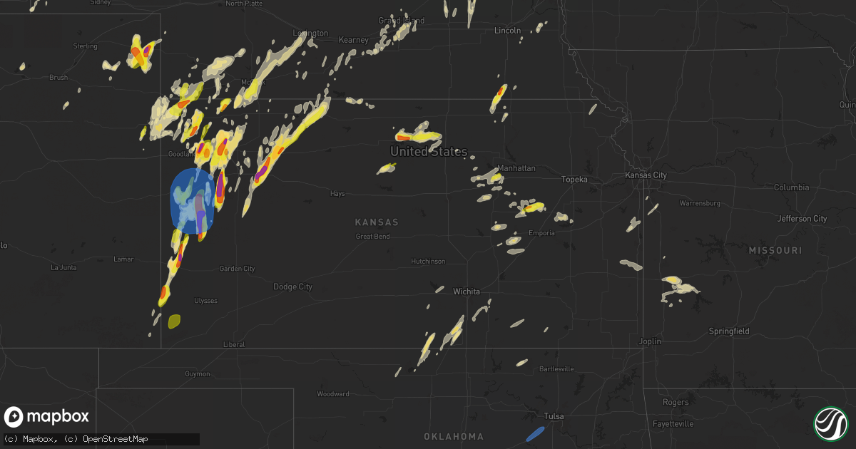
Hail Map in Kansas on April 25, 2024
Get this storm
April 25 map
$229
one time, instant access
Download today. No call, no setup
Keep the $229
Bought the map and want the full workflow? Apply the entire $229 to a subscription within 7 days. None of it is wasted.
Every map, not just this one
This buys you this map. Subscription and you get every map we run, in the markets you choose from a few cities to whole states to nationwide. Plus real-time alerts the moment a storm fires.
Contact data
Name, contact info, occupancy, even credit band for addresses in the footprint. You go from where it hit to who to call.
Become the source they trust
Unlimited branding weather history reports on demand. You already have the documented answer ready for the property owner, and you are the one who showed up with it.
Property data and RoofTrace estimates
Pull up any address you have got, its value and the exact code rules for that jurisdiction, straight from One Click Code. Then RoofTrace estimates the squares, pitch, and roof value, priced the way you price.
Storm reports in Kansas
Kansas
| Date | Description |
|---|---|
| 04/25/20246:55 PM CDT | Golf ball sized hail reported. |
| 04/25/20246:45 PM CDT | Corrects previous hail report from russell springs. Estimated time of report. |
| 04/25/20246:45 PM CDT | A local report indicates 1.75 inch wind near 16 N Syracuse |
| 04/25/20246:40 PM CDT | Reissued report. Report with photo via social media of hail up to 2 1/2 inch. |
| 04/25/20246:33 PM CDT | 2 inch hail reported. |
| 04/25/20246:30 PM CDT | Corrects previous hail report from 5 nw leoti. Social media report with pictures of hail mostly around 2 inches but at least one closer two and a half inches. |
| 04/25/20246:30 PM CDT | Delayed report via social media. Estimated 2-3 inch sized hail fell for roughly 30-45 minutes at the location. |
| 04/25/20246:30 PM CDT | A local report indicates 2.00 inch wind near 5 NW Leoti |
| 04/25/20246:28 PM CDT | Report from mping: golf ball |
| 04/25/20246:27 PM CDT | Report from mping: half dollar |
| 04/25/20246:22 PM CDT | Report from mping: golf ball |
| 04/25/20246:20 PM CDT | A local report indicates 1.75 inch wind near 3 NW Syracuse |
| 04/25/20246:19 PM CDT | Report from mping: ping pong ball |
| 04/25/20246:16 PM CDT | A local report indicates 1.00 inch wind near 2 S Brewster |
| 04/25/20246:14 PM CDT | C6099 in se wallace county recorded a gust of 70 mph. |
| 04/25/20246:14 PM CDT | Report via social media with photos of ping pong ball size hail. |
| 04/25/20246:13 PM CDT | A local report indicates 60 MPH wind near 8 N Marienthal |
| 04/25/20246:10 PM CDT | A local report indicates 60 MPH wind near Sharon Springs |
| 04/25/20246:10 PM CDT | A local report indicates 1.00 inch wind near 1 E Wallace |
| 04/25/20246:10 PM CDT | A local report indicates 1.00 inch wind near 7 WSW Syracuse |
| 04/25/20246:10 PM CDT | A local report indicates 1.00 inch wind near Sharon Springs |
| 04/25/20246:08 PM CDT | Report via social media with photo of measured hailstones... 2 inch. |
| 04/25/20246:06 PM CDT | Ongoing quarter to golf ball sized hail. |
| 04/25/20246:06 PM CDT | Trained spotter reports inch to 1 1/2 inch hail. |
| 04/25/20246:03 PM CDT | Trained spotter report via social media with photos and video of quarter to half dollar size hail. |
| 04/25/20246:00 PM CDT | Delayed report of public report of 1.25 inch hail in tribune... Photo was sent in. |
| 04/25/20246:00 PM CDT | Trained spotter reports measured 2 1/2 inch hail. East window was broken. |
| 04/25/20246:00 PM CDT | Public report with photo via social media of quarter size hail in tribune. |
| 04/25/20246:00 PM CDT | Estimated time of report. |
| 04/25/20245:58 PM CDT | Report from mping: hen egg |
| 04/25/20245:56 PM CDT | Heavy quarter to half dollar sized hail was ongoing for a duration of 2 minutes. |
| 04/25/20245:55 PM CDT | Delayed report via social media with photos of estimated racquet ball sized spikey hail near leoti. |
| 04/25/20245:53 PM CDT | A local report indicates 2.50 inch wind near 2 SSE Russell Springs |
| 04/25/20245:52 PM CDT | Report via social media with photo of quarter size hail in leoti. |
| 04/25/20245:50 PM CDT | Hail was ongoing at the time of the report. |
| 04/25/20245:50 PM CDT | Trained spotter reports hail up to size of golf balls. Photos sent via social media. |
| 04/25/20245:48 PM CDT | Trained spotter reports hail ranging from pea size to quarter size. |
| 04/25/20245:44 PM CDT | Hail was ongoing over i-70 at the time of the report. |
| 04/25/20245:44 PM CDT | Corrects previous hail report from 2 sse russell springs. Time via radar. |
| 04/25/20245:42 PM CDT | Report via social media of quarter size hail in colby. |
| 04/25/20245:41 PM CDT | Corrects previous hail report from colby. Hail was ongoing at time of report for a current duration of 5 minutes. |
| 04/25/20245:41 PM CDT | Hail was ongoing at time of report. |
| 04/25/20245:40 PM CDT | Time estimated via radar. |
| 04/25/20245:40 PM CDT | Time estimated via radar. |
| 04/25/20245:40 PM CDT | Corrects previous hail report from 5 nw leoti. Reissued report. Report with photo via social media of hail up to 2 1/2 inch. |
| 04/25/20245:36 PM CDT | Trained spotter reports 1 1/2 inch hail. |
| 04/25/20245:35 PM CDT | A local report indicates 1.75 inch wind near 13 NW Manter |
| 04/25/20245:31 PM CDT | A local report indicates 1.25 inch wind near 7 N Richfield |
| 04/25/20245:30 PM CDT | Report with photo via social media of hail up to 2 1/2 inch. |
| 04/25/20245:28 PM CDT | Trained spotter reports estimated quarter size hail. |
| 04/25/20245:15 PM CDT | Report from mping: golf ball |
| 04/25/20245:10 PM CDT | Trained spotter reports 1 3/8 inch diameter hail. |
| 04/25/20244:50 PM CDT | Report with photo via social media of quarter size hail. |
| 04/25/20244:47 PM CDT | Social media report with picture of hail stones around half dollar to golf ball in size. |
| 04/25/20244:45 PM CDT | Media reported a tornado east of hwy 27 & b. Location estimated based on radar. It lasted about 2-3 minutes. |
| 04/25/20244:45 PM CDT | Trained spotter reports hail up to around quarter size... Hail lasted around 15 minutes. |
| 04/25/20244:42 PM CDT | Short lived rope tornado reported with a duration of 5 minutes. Time and location via radar. |
| 04/25/20244:33 PM CDT | Delayed report via social media. Hail was found roughly 20 minutes after the storm passed. Time of lsr found via radar. |
| 04/25/20244:20 PM CDT | A local report indicates 1.00 inch wind near 14 SSE Bird City |
| 04/25/202412:52 PM CDT | A local report indicates 1.00 inch wind near 4 ESE Council Grove |
| 04/25/202411:37 AM CDT | Heavy rain falling. |
| 04/24/20249:10 PM CDT | Delayed report. Quarter sized hail with 90 0round coverage and torrential rainfall. |
| 04/24/20248:58 PM CDT | Report via social media |
| 04/24/20248:22 PM CDT | Emergency management relays reports of hail up to the size of golf balls. |
| 04/24/20248:20 PM CDT | Ping pong to egg sized hail observed in grainfield. |
| 04/24/20248:20 PM CDT | A local report indicates 1.00 inch wind near Grainfield |
| 04/24/20248:20 PM CDT | Public report via social media of hail quarter size to a few golf ball size. |
All States Impacted by Hail Map on April 25, 2024
Cities Impacted by Hail Map on April 25, 2024
- Naponee, NE
- Phillipsburg, KS
- Agra, KS
- Kensington, KS
- Cawker City, KS
- Glen Elder, KS
- Mankato, KS
- Esbon, KS
- Paris, AR
- Smith Center, KS
- Beloit, KS
- Dardanelle, AR
- Delaware, AR
- Belleville, AR
- New Blaine, AR
- Danville, AR
- Randall, KS
- Jewell, KS
- Jamestown, KS
- Concordia, KS
- Casa, AR
- Adona, AR
- Morrilton, AR
- Little Rock, AR
- Courtland, KS
- Ola, AR
- Perryville, AR
- Houston, AR
- Roland, AR
- Paron, AR
- Osborne, KS
- Portis, KS
- Downs, KS
- Alexander, AR
- Benton, AR
- Bryant, AR
- Bauxite, AR
- Glasco, KS
- Lucas, KS
- Sylvan Grove, KS
- Luray, KS
- Hunter, KS
- Miltonvale, KS
- Aurora, KS
- Clay Center, KS
- Cheney, KS
- Andale, KS
- Mount Hope, KS
- Garden Plain, KS
- Longford, KS
- Abilene, KS
- Junction City, KS
- Milford, KS
- Chapman, KS
- Wakefield, KS
- Shidler, OK
- Pawhuska, OK
- Riley, KS
- Fort Riley, KS
- Talmage, KS
- Enterprise, KS
- Hope, KS
- Woodbine, KS
- Dexter, KS
- Cambridge, KS
- Grenola, KS
- Dwight, KS
- Alta Vista, KS
- Council Grove, KS
- White City, KS
- Allen, KS
- Alma, KS
- Eskridge, KS
- Burdick, KS
- Lincolnville, KS
- Strong City, KS
- Douglas, WY
- Cedar Point, KS
- Florence, KS
- Cottonwood Falls, KS
- Elmdale, KS
- Reading, KS
- Shawnee, WY
- Newcastle, WY
- Osage City, KS
- Matfield Green, KS
- Edgemont, SD
- Lebo, KS
- Custer, SD
- Mud Butte, SD
- Keystone, SD
- Rapid City, SD
- Faith, SD
- Hot Springs, SD
- Wheatland, WY
- Buffalo Gap, SD
- Fairburn, SD
- Woodrow, CO
- Mapleton, KS
- Blue Mound, KS
- Goodland, KS
- Saint Francis, KS
- Oral, SD
- Torrington, WY
- Bird City, KS
- Edson, KS
- Mound City, KS
- McDonald, KS
- Yoder, WY
- Hermosa, SD
- Scenic, SD
- Prescott, KS
- Fort Scott, KS
- Fulton, KS
- Dupree, SD
- Hawk Springs, WY
- Pine Ridge, SD
- New Underwood, SD
- Parks, NE
- Akron, CO
- Wall, SD
- Wasta, SD
- Owanka, SD
- Benkelman, NE
- Atwood, KS
- Caputa, SD
- Ludlow, SD
- Reva, SD
- Walsh, CO
- Colby, KS
- Otis, CO
- Yuma, CO
- Quinn, SD
- Winona, KS
- Leoti, KS
- Nevada, MO
- Morrill, NE
- Elkhart, KS
- Richfield, KS
- Walker, MO
- Jerico Springs, MO
- El Dorado Springs, MO
- Sheldon, MO
- Scranton, ND
- Johnson, KS
- Levant, KS
- Stockton, MO
- White Owl, SD
- Howes, SD
- Manter, KS
- Interior, SD
- Syracuse, KS
- Kadoka, SD
- Philip, SD
- Milo, MO
- Holyoke, CO
- Culbertson, NE
- Tribune, KS
- Wray, CO
- Herndon, KS
- Stratton, NE
- Trenton, NE
- Brewster, KS
- Monument, KS
- Haxtun, CO
- Sharon Springs, KS
- Wallace, KS
- Paoli, CO
- Wanblee, SD
- Orchard, CO
- Kersey, CO
- McCook, NE
- Lamar, MO
- Oberlin, KS
- Mitchell, NE
- Scottsbluff, NE
- Amherst, CO
- Minatare, NE
- Bushnell, NE
- Ludell, KS
- Harrisburg, NE
- Kimball, NE
- Weskan, KS
- Indianola, NE
- Ovid, CO
- Sedgwick, CO
- Amidon, ND
- Curtis, NE
- Stockville, NE
- Bayard, NE
- Oakley, KS
- Hoxie, KS
- Moorefield, NE
- Scott City, KS
- Rexford, KS
- Healy, KS
- Farnam, NE
- Eustis, NE
- Grinnell, KS
- Selden, KS
- Venango, NE
- Rushville, NE
- Smithfield, NE
- Bertrand, NE
- Angora, NE
- Elwood, NE
- Lexington, NE
- Gove, KS
- Grainfield, KS
- Idalia, CO
- Burlington, CO
- Dresden, KS
- Jennings, KS
- Bethune, CO
- Norton, KS
- Clayton, KS
- Waterville, KS
- Park, KS
- Loomis, NE
- Barnes, KS
- Hanover, KS
- Washington, KS
- Marysville, KS
- Atlanta, NE
- Hollenberg, KS
- Odell, NE
- Haigler, NE
- Gem, KS
- Morland, KS
- Almena, KS
- Wymore, NE
- Gordon, NE
- Bremen, KS
- Wood River, NE
- Blue Springs, NE
- Penokee, KS
- Hill City, KS
- Seminole, TX
- Orleans, NE
- Stamford, NE
- Lenora, KS
- Beatrice, NE
- Holdrege, NE
- Armour, SD
- Lake Andes, SD
- Grand Island, NE
- Cairo, NE
- Axtell, NE
- Funk, NE
- Minden, NE
- Heartwell, NE
- Enders, NE
- Max, NE
- Prairie View, KS
- Seagraves, TX
- Kenesaw, NE
- Palisade, NE
- Wauneta, NE
- Imperial, NE
- Saint Libory, NE
- Long Island, KS
- Wilcox, NE
- Benedict, NE
- Archer, NE
- Palmer, NE
- Loop, TX
- Doniphan, NE
- Hastings, NE
- Trumbull, NE
- Alda, NE
- Polk, NE
- Stromsburg, NE
- Utica, NE
- York, NE
- Juniata, NE
- Beaver Crossing, NE
- Alma, NE
- Phillips, NE
- Aurora, NE
- Welch, TX
- Brownfield, TX
- Tahoka, TX
- Waco, NE
- Ulysses, NE
- Gresham, NE
- Staplehurst, NE
- Surprise, NE
- Kanorado, KS
- Hayes Center, NE
- Odonnell, TX
- Rising City, NE
- Giltner, NE
- Bennet, NE
- Post, TX
- Maywood, NE
- Wilson, TX
- Unadilla, NE
- Elmwood, NE
- Avoca, NE
- Weeping Water, NE
- Manley, NE
- Ralls, TX
- Osceola, NE
- Crosbyton, TX
- David City, NE
- Spur, TX
- Louisville, NE
- Murdock, NE
- Arapahoe, NE
- Holbrook, NE
- Justiceburg, TX
- Dickens, TX
- Edison, NE
- Snyder, TX
- Girard, TX
- Jayton, TX
- Paducah, TX
- Fontana, KS
- Sedan, KS
- Aspermont, TX
- La Cygne, KS
- Paola, KS
- Malmo, NE
- Weston, NE
- Prague, NE
- Bellwood, NE
- Cedar Bluffs, NE
- Morse Bluff, NE
- Louisburg, KS
- Peculiar, MO
- Cleveland, MO
- Freeman, MO
- Big Lake, TX
- Harrisonville, MO
- Pleasant Hill, MO
- Robinson, KS
- Crowell, TX
- Seymour, TX
- White Cloud, KS
- Old Glory, TX
- Electra, TX
- Raymore, MO
- Belton, MO
- Oklahoma City, OK
- Lookeba, OK
- Kansas City, MO
- Loveland, OK
- Hinton, OK
- Cache, OK
- Chattanooga, OK
- Lawton, OK
- Holliday, TX
- Hollister, OK
- Indiahoma, OK
- Davidson, OK
- Frederick, OK
- Anthony, KS
- Benjamin, TX
- Carmen, OK
- Cherokee, OK
- Jet, OK
- Nash, OK
- Rich Hill, MO
- Wakita, OK
- Manchester, OK
- Goree, TX
- Bluff City, KS
- Medford, OK
- Wichita Falls, TX
- Elgin, OK
- Kingman, KS
- Amber, OK
- Chickasha, OK
- Freeport, KS
- Caldwell, KS
- Mayfield, KS
- Wellington, KS
- Tuttle, OK
- Mulvane, KS
- Belle Plaine, KS
- Newcastle, OK
- Blanchard, OK
- Harrah, OK
- Udall, KS
- Douglass, KS
- Mcloud, OK
- Newalla, OK
- Wellston, OK
- Luther, OK
- Augusta, KS
- Rock, KS
- Shawnee, OK
- Choctaw, OK
- Meeker, OK
- Prague, OK
- Healdton, OK
- Wilson, OK
- Ardmore, OK
- Springer, OK
- Lone Grove, OK
- Davis, OK
- Sulphur, OK
- Dougherty, OK
- Wynnewood, OK
- Mill Creek, OK
- Paden, OK
- Roff, OK
- Boley, OK
- Tishomingo, OK
- Okemah, OK
- Castle, OK
- Stonewall, OK
- Fitzhugh, OK
- Fittstown, OK
- Ada, OK
- Graham, OK
- Bartley, NE
- Henrietta, TX
- Weleetka, OK
- Bristow, OK
- Kellyville, OK
- Sapulpa, OK
- Henryetta, OK
- Checotah, OK
- Council Hill, OK
- Oktaha, OK
- Eufaula, OK
- Boynton, OK
- Muskogee, OK
- Cozad, NE
- Kiowa, OK
- Stuart, OK
- Wardville, OK
- Mcalester, OK
- Okmulgee, OK


