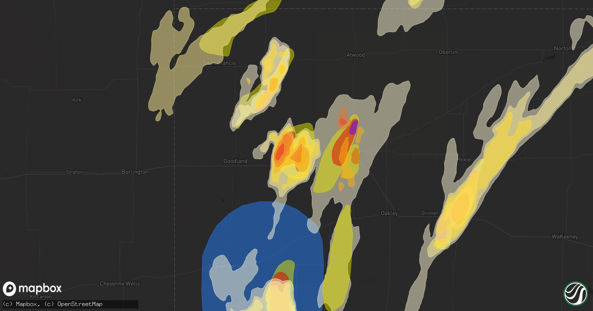
Hail Map in Brewster, KS on April 25, 2024
Get this storm
April 25 map
$229
one time, instant access
Download today. No call, no setup
Keep the $229
Bought the map and want the full workflow? Apply the entire $229 to a subscription within 7 days. None of it is wasted.
Every map, not just this one
This buys you this map. Subscription and you get every map we run, in the markets you choose from a few cities to whole states to nationwide. Plus real-time alerts the moment a storm fires.
Contact data
Name, contact info, occupancy, even credit band for addresses in the footprint. You go from where it hit to who to call.
Become the source they trust
Unlimited branding weather history reports on demand. You already have the documented answer ready for the property owner, and you are the one who showed up with it.
Property data and RoofTrace estimates
Pull up any address you have got, its value and the exact code rules for that jurisdiction, straight from One Click Code. Then RoofTrace estimates the squares, pitch, and roof value, priced the way you price.
Storm reports in Brewster, KS
Brewster, KS
| Date | Description |
|---|---|
| 04/25/20246:30 PM CDT | Delayed report via social media. Estimated 2-3 inch sized hail fell for roughly 30-45 minutes at the location. |
| 04/25/20246:19 PM CDT | Report from mping: ping pong ball |
| 04/25/20246:16 PM CDT | A local report indicates 1.00 inch wind near 2 S Brewster |
All States Impacted by Hail Map on April 25, 2024
All Cities Impacted by Hail Map on April 25, 2024
- Naponee, NE
- Phillipsburg, KS
- Agra, KS
- Kensington, KS
- Cawker City, KS
- Glen Elder, KS
- Mankato, KS
- Esbon, KS
- Paris, AR
- Smith Center, KS
- Beloit, KS
- Dardanelle, AR
- Delaware, AR
- Belleville, AR
- New Blaine, AR
- Danville, AR
- Randall, KS
- Jewell, KS
- Jamestown, KS
- Concordia, KS
- Casa, AR
- Adona, AR
- Morrilton, AR
- Little Rock, AR
- Courtland, KS
- Ola, AR
- Perryville, AR
- Houston, AR
- Roland, AR
- Paron, AR
- Osborne, KS
- Portis, KS
- Downs, KS
- Alexander, AR
- Benton, AR
- Bryant, AR
- Bauxite, AR
- Glasco, KS
- Lucas, KS
- Sylvan Grove, KS
- Luray, KS
- Hunter, KS
- Miltonvale, KS
- Aurora, KS
- Clay Center, KS
- Cheney, KS
- Andale, KS
- Mount Hope, KS
- Garden Plain, KS
- Longford, KS
- Abilene, KS
- Junction City, KS
- Milford, KS
- Chapman, KS
- Wakefield, KS
- Shidler, OK
- Pawhuska, OK
- Riley, KS
- Fort Riley, KS
- Talmage, KS
- Enterprise, KS
- Hope, KS
- Woodbine, KS
- Dexter, KS
- Cambridge, KS
- Grenola, KS
- Dwight, KS
- Alta Vista, KS
- Council Grove, KS
- White City, KS
- Allen, KS
- Alma, KS
- Eskridge, KS
- Burdick, KS
- Lincolnville, KS
- Strong City, KS
- Douglas, WY
- Cedar Point, KS
- Florence, KS
- Cottonwood Falls, KS
- Elmdale, KS
- Reading, KS
- Shawnee, WY
- Newcastle, WY
- Osage City, KS
- Matfield Green, KS
- Edgemont, SD
- Lebo, KS
- Custer, SD
- Mud Butte, SD
- Keystone, SD
- Rapid City, SD
- Faith, SD
- Hot Springs, SD
- Wheatland, WY
- Buffalo Gap, SD
- Fairburn, SD
- Woodrow, CO
- Mapleton, KS
- Blue Mound, KS
- Goodland, KS
- Saint Francis, KS
- Oral, SD
- Torrington, WY
- Bird City, KS
- Edson, KS
- Mound City, KS
- McDonald, KS
- Yoder, WY
- Hermosa, SD
- Scenic, SD
- Prescott, KS
- Fort Scott, KS
- Fulton, KS
- Dupree, SD
- Hawk Springs, WY
- Pine Ridge, SD
- New Underwood, SD
- Parks, NE
- Akron, CO
- Wall, SD
- Wasta, SD
- Owanka, SD
- Benkelman, NE
- Atwood, KS
- Caputa, SD
- Ludlow, SD
- Reva, SD
- Walsh, CO
- Colby, KS
- Otis, CO
- Yuma, CO
- Quinn, SD
- Winona, KS
- Leoti, KS
- Nevada, MO
- Morrill, NE
- Elkhart, KS
- Richfield, KS
- Walker, MO
- Jerico Springs, MO
- El Dorado Springs, MO
- Sheldon, MO
- Scranton, ND
- Johnson, KS
- Levant, KS
- Stockton, MO
- White Owl, SD
- Howes, SD
- Manter, KS
- Interior, SD
- Syracuse, KS
- Kadoka, SD
- Philip, SD
- Milo, MO
- Holyoke, CO
- Culbertson, NE
- Tribune, KS
- Wray, CO
- Herndon, KS
- Stratton, NE
- Trenton, NE
- Brewster, KS
- Monument, KS
- Haxtun, CO
- Sharon Springs, KS
- Wallace, KS
- Paoli, CO
- Wanblee, SD
- Orchard, CO
- Kersey, CO
- McCook, NE
- Lamar, MO
- Oberlin, KS
- Mitchell, NE
- Scottsbluff, NE
- Amherst, CO
- Minatare, NE
- Bushnell, NE
- Ludell, KS
- Harrisburg, NE
- Kimball, NE
- Weskan, KS
- Indianola, NE
- Ovid, CO
- Sedgwick, CO
- Amidon, ND
- Curtis, NE
- Stockville, NE
- Bayard, NE
- Oakley, KS
- Hoxie, KS
- Moorefield, NE
- Scott City, KS
- Rexford, KS
- Healy, KS
- Farnam, NE
- Eustis, NE
- Grinnell, KS
- Selden, KS
- Venango, NE
- Rushville, NE
- Smithfield, NE
- Bertrand, NE
- Angora, NE
- Elwood, NE
- Lexington, NE
- Gove, KS
- Grainfield, KS
- Idalia, CO
- Burlington, CO
- Dresden, KS
- Jennings, KS
- Bethune, CO
- Norton, KS
- Clayton, KS
- Waterville, KS
- Park, KS
- Loomis, NE
- Barnes, KS
- Hanover, KS
- Washington, KS
- Marysville, KS
- Atlanta, NE
- Hollenberg, KS
- Odell, NE
- Haigler, NE
- Gem, KS
- Morland, KS
- Almena, KS
- Wymore, NE
- Gordon, NE
- Bremen, KS
- Wood River, NE
- Blue Springs, NE
- Penokee, KS
- Hill City, KS
- Seminole, TX
- Orleans, NE
- Stamford, NE
- Lenora, KS
- Beatrice, NE
- Holdrege, NE
- Armour, SD
- Lake Andes, SD
- Grand Island, NE
- Cairo, NE
- Axtell, NE
- Funk, NE
- Minden, NE
- Heartwell, NE
- Enders, NE
- Max, NE
- Prairie View, KS
- Seagraves, TX
- Kenesaw, NE
- Palisade, NE
- Wauneta, NE
- Imperial, NE
- Saint Libory, NE
- Long Island, KS
- Wilcox, NE
- Benedict, NE
- Archer, NE
- Palmer, NE
- Loop, TX
- Doniphan, NE
- Hastings, NE
- Trumbull, NE
- Alda, NE
- Polk, NE
- Stromsburg, NE
- Utica, NE
- York, NE
- Juniata, NE
- Beaver Crossing, NE
- Alma, NE
- Phillips, NE
- Aurora, NE
- Welch, TX
- Brownfield, TX
- Tahoka, TX
- Waco, NE
- Ulysses, NE
- Gresham, NE
- Staplehurst, NE
- Surprise, NE
- Kanorado, KS
- Hayes Center, NE
- Odonnell, TX
- Rising City, NE
- Giltner, NE
- Bennet, NE
- Post, TX
- Maywood, NE
- Wilson, TX
- Unadilla, NE
- Elmwood, NE
- Avoca, NE
- Weeping Water, NE
- Manley, NE
- Ralls, TX
- Osceola, NE
- Crosbyton, TX
- David City, NE
- Spur, TX
- Louisville, NE
- Murdock, NE
- Arapahoe, NE
- Holbrook, NE
- Justiceburg, TX
- Dickens, TX
- Edison, NE
- Snyder, TX
- Girard, TX
- Jayton, TX
- Paducah, TX
- Fontana, KS
- Sedan, KS
- Aspermont, TX
- La Cygne, KS
- Paola, KS
- Malmo, NE
- Weston, NE
- Prague, NE
- Bellwood, NE
- Cedar Bluffs, NE
- Morse Bluff, NE
- Louisburg, KS
- Peculiar, MO
- Cleveland, MO
- Freeman, MO
- Big Lake, TX
- Harrisonville, MO
- Pleasant Hill, MO
- Robinson, KS
- Crowell, TX
- Seymour, TX
- White Cloud, KS
- Old Glory, TX
- Electra, TX
- Raymore, MO
- Belton, MO
- Oklahoma City, OK
- Lookeba, OK
- Kansas City, MO
- Loveland, OK
- Hinton, OK
- Cache, OK
- Chattanooga, OK
- Lawton, OK
- Holliday, TX
- Hollister, OK
- Indiahoma, OK
- Davidson, OK
- Frederick, OK
- Anthony, KS
- Benjamin, TX
- Carmen, OK
- Cherokee, OK
- Jet, OK
- Nash, OK
- Rich Hill, MO
- Wakita, OK
- Manchester, OK
- Goree, TX
- Bluff City, KS
- Medford, OK
- Wichita Falls, TX
- Elgin, OK
- Kingman, KS
- Amber, OK
- Chickasha, OK
- Freeport, KS
- Caldwell, KS
- Mayfield, KS
- Wellington, KS
- Tuttle, OK
- Mulvane, KS
- Belle Plaine, KS
- Newcastle, OK
- Blanchard, OK
- Harrah, OK
- Udall, KS
- Douglass, KS
- Mcloud, OK
- Newalla, OK
- Wellston, OK
- Luther, OK
- Augusta, KS
- Rock, KS
- Shawnee, OK
- Choctaw, OK
- Meeker, OK
- Prague, OK
- Healdton, OK
- Wilson, OK
- Ardmore, OK
- Springer, OK
- Lone Grove, OK
- Davis, OK
- Sulphur, OK
- Dougherty, OK
- Wynnewood, OK
- Mill Creek, OK
- Paden, OK
- Roff, OK
- Boley, OK
- Tishomingo, OK
- Okemah, OK
- Castle, OK
- Stonewall, OK
- Fitzhugh, OK
- Fittstown, OK
- Ada, OK
- Graham, OK
- Bartley, NE
- Henrietta, TX
- Weleetka, OK
- Bristow, OK
- Kellyville, OK
- Sapulpa, OK
- Henryetta, OK
- Checotah, OK
- Council Hill, OK
- Oktaha, OK
- Eufaula, OK
- Boynton, OK
- Muskogee, OK
- Cozad, NE
- Kiowa, OK
- Stuart, OK
- Wardville, OK
- Mcalester, OK
- Okmulgee, OK


