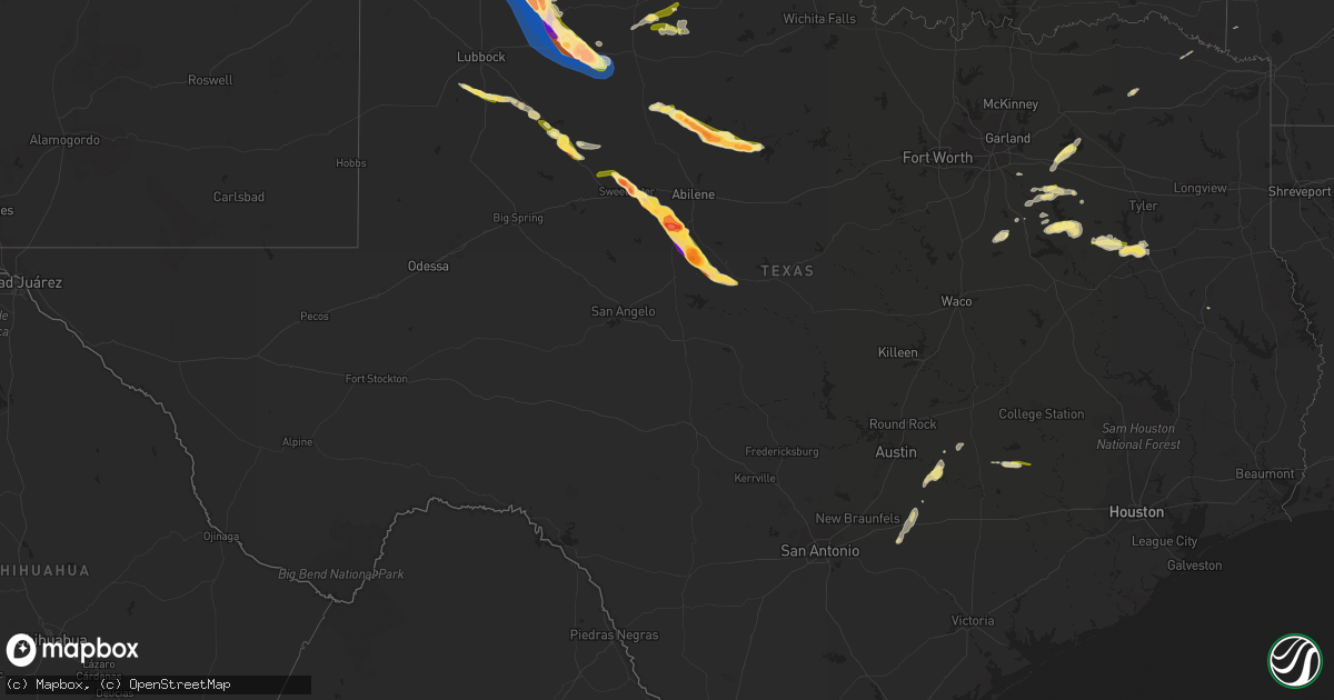
Hail Map in Texas on April 25, 2023
Get this storm
April 25 map
$229
one time, instant access
Download today. No call, no setup
Keep the $229
Bought the map and want the full workflow? Apply the entire $229 to a subscription within 7 days. None of it is wasted.
Every map, not just this one
This buys you this map. Subscription and you get every map we run, in the markets you choose from a few cities to whole states to nationwide. Plus real-time alerts the moment a storm fires.
Contact data
Name, contact info, occupancy, even credit band for addresses in the footprint. You go from where it hit to who to call.
Become the source they trust
Unlimited branding weather history reports on demand. You already have the documented answer ready for the property owner, and you are the one who showed up with it.
Property data and RoofTrace estimates
Pull up any address you have got, its value and the exact code rules for that jurisdiction, straight from One Click Code. Then RoofTrace estimates the squares, pitch, and roof value, priced the way you price.
Storm reports in Texas
Texas
| Date | Description |
|---|---|
| 04/25/20236:53 PM CDT | A local report indicates 1.25 inch wind near 10 NW TULIA |
| 04/25/20236:51 PM CDT | A local report indicates 1.00 inch wind near BASTROP |
| 04/25/20236:51 PM CDT | 1/2 to 3/4 mile length of sporadic tree and fence damage between 2800 block of north main street and 200 block of sayers road. |
| 04/25/20236:36 PM CDT | A local report indicates 1.00 inch wind near STRATFORD |
| 04/25/20236:32 PM CDT | A local report indicates 1.00 inch wind near 6 W CAPITOLA |
| 04/25/20233:10 AM CDT | A picture was posted to facebook of quarter to half dollar size hail that fell near jacksonville high school. |
| 04/25/20231:57 AM CDT | A local report indicates 1.00 inch wind near 6 NE AVOCA |
| 04/25/20231:30 AM CDT | A local report indicates 1.75 inch wind near 7 NNE STAMFORD |
| 04/25/202312:51 AM CDT | Delayed report: public reported half dollar size hail near malakoff. |
| 04/25/202312:29 AM CDT | Public reported quarter size hail northwest of trinidad. |
| 04/24/202311:53 PM CDT | Social media reported quarter size hail near kemp. |
| 04/24/202310:45 PM CDT | A local report indicates 1.75 inch wind near 5 SSW SANTA ANNA |
| 04/24/202310:09 PM CDT | Dickens county sheriff reports multiple windows blown out in town from wind-driven hail. Time estimated from radar. |
| 04/24/202310:08 PM CDT | Extensive damage to property and vehicles. Numerous windows broken. |
| 04/24/202310:08 PM CDT | Broadcast media relayed photo of estimated 3 inch hail in dickens. Time estimated from radar. |
| 04/24/202310:06 PM CDT | A local report indicates 2.75 inch wind near DICKENS |
| 04/24/202310:00 PM CDT | Corrects previous hail report from 3 ssw glen cove. Large hail lasted 30 minutes 950 pm-1020 pm. |
| 04/24/20239:50 PM CDT | A local report indicates 1.75 inch wind near GLEN COVE |
| 04/24/20239:50 PM CDT | A local report indicates 1.75 inch wind near 3 SSW GLEN COVE |
| 04/24/20239:44 PM CDT | Golf ball size hail reported by mcadoo fire. |
| 04/24/20239:42 PM CDT | Em reports roof blown off of gas station in mcadoo. Time estimated from radar. |
| 04/24/20239:39 PM CDT | West texas mesonet. Additional gusts ranging from 66 mph to 87 mph measured from 937 pm to 942 pm. |
| 04/24/20239:39 PM CDT | West texas mesonet. Additional gusts ranging from 60 mph to 87 mph measured from 937 pm to 942 pm. Sustained wind of 68 mph measured at 940 pm. |
| 04/24/20239:37 PM CDT | Quarter sized hail at blinn college. |
| 04/24/20239:35 PM CDT | A local report indicates 3.50 inch wind near 2 ESE CREWS |
| 04/24/20239:30 PM CDT | A local report indicates 2.00 inch wind near CREWS |
| 04/24/20239:25 PM CDT | Hail observed near us84 and cr258. |
| 04/24/20238:55 PM CDT | Social media video of tennis ball size hail. Time estimated from radar. |
| 04/24/20238:54 PM CDT | A local report indicates 2.50 inch wind near 1 NE BRADSHAW |
| 04/24/20238:45 PM CDT | A local report indicates 2.75 inch wind near 8 NNE HAPPY VALLEY |
| 04/24/20238:40 PM CDT | A local report indicates 2.75 inch wind near 10 N FLOYDADA |
| 04/24/20238:28 PM CDT | Estimated quarter size hail by a trained spotter. |
| 04/24/20238:28 PM CDT | Estimated |
| 04/24/20238:25 PM CDT | A local report indicates 3.00 inch wind near 8 NE HAPPY VALLEY |
| 04/24/20238:20 PM CDT | A local report indicates 2.00 inch wind near 7 E NOLAN |
| 04/24/20237:30 PM CDT | A local report indicates 2.75 inch wind near 2 S TULIA |
| 04/24/20237:20 PM CDT | Report from mping: baseball |
| 04/24/20237:18 PM CDT | Report from mping: hen egg+ |
| 04/24/20237:15 PM CDT | So report relayed by em. |
| 04/24/20237:15 PM CDT | So report relayed by em |
| 04/24/20237:15 PM CDT | A local report indicates 1.75 inch wind near 4 ENE SWEETWATER |
| 04/24/20237:13 PM CDT | A local report indicates 1.75 inch wind near 1 NNW SWEETWATER |
| 04/24/20237:10 PM CDT | Report from mping: hen egg |
| 04/24/20237:00 PM CDT | A local report indicates 2.00 inch wind near 6 NW SWEETWATER |
Cities Impacted by Hail Map on April 25, 2023
- Summerfield, FL
- The Villages, FL
- Lady Lake, FL
- Weirsdale, FL
- Sumterville, FL
- Center Hill, FL
- Groveland, FL
- Vero Beach, FL
- Fruitland Park, FL
- Leesburg, FL
- Mascotte, FL
- Clermont, FL
- Fort Pierce, FL
- Keenesburg, CO
- Port Saint Lucie, FL
- Orlando, FL
- Winter Garden, FL
- Davenport, FL
- Kissimmee, FL
- Grenville, NM
- Hereford, TX
- Canyon, TX
- Townsend, GA
- Ocala, FL
- Seffner, FL
- Dover, FL
- Windermere, FL
- Polk City, FL
- Folsom, NM
- Astatula, FL
- Belleview, FL
- Oxford, FL
- Tavares, FL
- Howey In The Hills, FL
- Montverde, FL
- Yalaha, FL
- Oakland, FL
- Bushnell, FL
- Webster, FL
- Happy, TX
- Tahoka, TX
- Stratford, TX
- Gruver, TX
- Sunray, TX
- Spearman, TX
- Sweetwater, TX
- Hermleigh, TX
- Roby, TX
- Tulia, TX
- Kress, TX
- Trent, TX
- Nolan, TX
- Merkel, TX
- Dumas, TX
- Plainview, TX
- Lockney, TX
- Silverton, TX
- Tuscola, TX
- Wingate, TX
- Stinnett, TX
- Fritch, TX
- Ovalo, TX
- Justiceburg, TX
- Masterson, TX
- Floydada, TX
- Snyder, TX
- Fluvanna, TX
- Winters, TX
- Lawn, TX
- Borger, TX
- Panhandle, TX
- Crosbyton, TX
- Mcadoo, TX
- Goldsboro, TX
- Novice, TX
- Dickens, TX
- Talpa, TX
- Coleman, TX
- Ralls, TX
- Spur, TX
- Brenham, TX
- Burton, TX
- Valera, TX
- Santa Anna, TX
- Dalhart, TX
- Paige, TX
- Lexington, TX
- Quitman, GA
- Fargo, GA
- Abilene, TX
- Lee, FL
- Madison, FL
- Leesville, TX
- Gonzales, TX
- Hartley, TX
- Wilson, TX
- Post, TX
- Luling, TX
- Carmine, TX
- Cedar Creek, TX
- Bastrop, TX
- Red Rock, TX
- McDade, TX
- Harwood, TX
- Dale, TX
- Valdosta, GA
- Jasper, FL
- Live Oak, FL
- Terrell, TX
- Wills Point, TX
- Kemp, TX
- Kaufman, TX
- Barry, TX
- Trinidad, TX
- Kerens, TX
- Nashville, GA
- Old Glory, TX
- Rule, TX
- Haskell, TX
- Stamford, TX
- Avoca, TX
- Lueders, TX
- Montalba, TX
- Athens, TX
- Palestine, TX
- Larue, TX
- Frankston, TX
- Malakoff, TX
- Mabank, TX
- Albany, TX
- Jacksonville, TX
- Scurry, TX
- Avery, TX
- Matador, TX
- Dimmitt, TX
- Annona, TX
- Canton, TX
- Point, TX
- Lone Oak, TX
- Sulphur Bluff, TX
- Dike, TX
- Eustace, TX
- Blooming Grove, TX
- Rice, TX
- Ennis, TX
- Frost, TX
- Ledbetter, TX
- Seagoville, TX
- Childress, TX
- Quanah, TX
- Paducah, TX
- Crowell, TX
- Seymour, TX
- Chatfield, TX
- Cee Vee, TX
- Winthrop, AR
- Foreman, AR
- Flomot, TX
- Nacogdoches, TX
- Breckenridge, TX
- Bullard, TX
- Hart, TX
- Du Pont, GA


