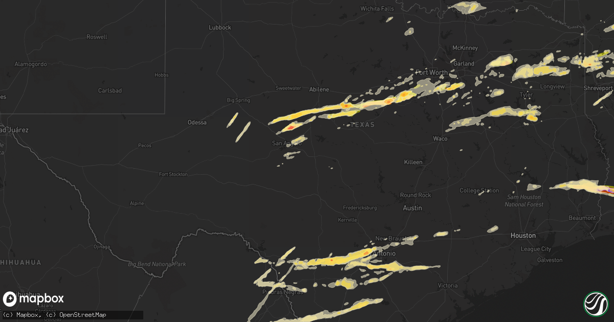
Hail Map in Texas on April 24, 2015
Get this storm
April 24 map
$229
one time, instant access
Download today. No call, no setup
Keep the $229
Bought the map and want the full workflow? Apply the entire $229 to a subscription within 7 days. None of it is wasted.
Every map, not just this one
This buys you this map. Subscription and you get every map we run, in the markets you choose from a few cities to whole states to nationwide. Plus real-time alerts the moment a storm fires.
Contact data
Name, contact info, occupancy, even credit band for addresses in the footprint. You go from where it hit to who to call.
Become the source they trust
Unlimited branding weather history reports on demand. You already have the documented answer ready for the property owner, and you are the one who showed up with it.
Property data and RoofTrace estimates
Pull up any address you have got, its value and the exact code rules for that jurisdiction, straight from One Click Code. Then RoofTrace estimates the squares, pitch, and roof value, priced the way you price.
Storm reports in Texas
Texas
| Date | Description |
|---|---|
| 04/24/20156:55 PM CDT | Trees uprooted |
| 04/24/20156:50 PM CDT | Nickel to quarter size hail reported by border patrol. |
| 04/24/20156:46 PM CDT | Residential roof damage and trees branches downed near new york and arbrook |
| 04/24/20156:46 PM CDT | Near new york and arbrook |
| 04/24/20156:45 PM CDT | Wide spread tree damage... Damage to car ports as well |
| 04/24/20156:42 PM CDT | Us67 ad fm157 |
| 04/24/20156:29 PM CDT | Tree down in street... Large limbs down throughout area |
| 04/24/20156:22 PM CDT | 70-80 mph wind |
| 04/24/20156:15 PM CDT | Tcu area |
| 04/24/20156:14 PM CDT | Hwy377 and tiger trail |
| 04/24/20156:14 PM CDT | A local report indicates 1.00 inch wind near CRESSON |
| 04/24/20156:12 PM CDT | Building damage |
| 04/24/20156:06 PM CDT | 65 to 70 mph at comanche peak |
| 04/24/20156:00 PM CDT | A local report indicates 60 MPH wind near GLEN ROSE |
| 04/24/20155:54 PM CDT | 2 feet diameter tree uprooted |
| 04/24/20155:38 PM CDT | Relayed from the tolar fire department |
| 04/24/20155:34 PM CDT | A local report indicates 1.75 inch wind near STEPHENVILLE |
| 04/24/20155:30 PM CDT | A local report indicates 80 MPH wind near STEPHENVILLE |
| 04/24/20155:17 PM CDT | Trees reported down near de leon |
| 04/24/20155:15 PM CDT | A local report indicates 60 MPH wind near COLEMAN |
| 04/24/20155:10 PM CDT | 70-80 mph winds blew down trees |
| 04/24/20155:08 PM CDT | Trees down mary st and and shady creek |
| 04/24/20154:47 PM CDT | A local report indicates 60 MPH wind near PAINT ROCK |
| 04/24/20154:38 PM CDT | A local report indicates 2.00 inch wind near CROSS PLAINS |
| 04/24/20154:34 PM CDT | A local report indicates 1.00 inch wind near LOWAKE |
| 04/24/20154:30 PM CDT | Numerous trees down across the city. Some trees down on cars. |
| 04/24/20154:23 PM CDT | A local report indicates 1.00 inch wind near ECHO |
| 04/24/20154:22 PM CDT | A local report indicates 70 MPH wind near 3 NE WALL |
| 04/24/20154:18 PM CDT | A local report indicates 1.00 inch wind near MILES |
| 04/24/20154:06 PM CDT | A local report indicates 61 MPH wind near 6 SW SAN ANGELO |
| 04/24/20154:05 PM CDT | A local report indicates 61 MPH wind near 6 SW SAN ANGELO |
| 04/24/20154:05 PM CDT | Tornado reported at lake coleman. |
| 04/24/20154:05 PM CDT | A car port was blown 100 feet and severly damaged. Also... Large tree branches were blown down and a slide was damaged. A possible tornado. |
| 04/24/20153:53 PM CDT | Large tree limbs down on fm 382. |
| 04/24/20153:50 PM CDT | 4 trees down...21 inches in diameter at fm 382 and fm 2647. |
| 04/24/20153:45 PM CDT | Storm chaser reported a tornado on thr ground west of novice. |
| 04/24/20153:45 PM CDT | A local report indicates 70 MPH wind near 5 W NOVICE |
| 04/24/20153:22 PM CDT | A local report indicates 60 MPH wind near WINTERS |
| 04/24/20153:15 PM CDT | A local report indicates 60 MPH wind near 5 NW TENNYSON |
| 04/24/20153:15 PM CDT | A local report indicates 2.75 inch wind near 5 NW TENNYSON |
| 04/24/20153:09 PM CDT | Hail busted numerous vehicle windows. |
| 04/24/20153:08 PM CDT | A local report indicates 1.00 inch wind near WINGATE |
| 04/24/20152:57 PM CDT | A local report indicates 1.75 inch wind near 4 N BRONTE |
| 04/24/20152:38 PM CDT | Residential roofs damaged. |
| 04/24/20152:28 PM CDT | A local report indicates 1.25 inch wind near 8 W ROBERT LEE |
| 04/24/20151:30 PM CDT | Scattered roof damage. Some debris on main street. |
| 04/24/20151:10 PM CDT | Measured by the west tx mesonet near northfield. |
| 04/24/201512:30 PM CDT | Law enforcement reported trees down in call |
| 04/24/201512:20 PM CDT | 24 inch diameter tree down. |
| 04/24/201512:20 PM CDT | Nws storm survey determined an ef1 tornado uprooted or snapped numerous trees from ese of call tx to fields la. At least one home had a tree fall on it. |
| 04/24/201512:20 PM CDT | A local report indicates 60 MPH wind near 7 NW KIRBYVILLE |
| 04/24/201512:05 PM CDT | Tree on top of house. |
| 04/24/201511:58 AM CDT | Nws storm survey determined an ef1 tornado caused damage to trees...homes...and outbuildings from west of kirbyville to the trout creek community of newton texas. |
| 04/24/20156:55 AM CDT | Storm spotter measured 58 gust to 69 mph hwy 99 and franz road. |
| 04/24/20156:40 AM CDT | Minor tree damage in san felipe. |
| 04/24/20155:48 AM CDT | Trees and powerlines reported down |
| 04/24/20155:25 AM CDT | A local report indicates 1.00 inch wind near FLORESVILLE |
| 04/24/20155:20 AM CDT | A local report indicates 1.75 inch wind near 4 WNW FLORESVILLE |
| 04/24/20155:11 AM CDT | Cluster of large trees blown down and damaged sturdy pipe fencing |
| 04/24/20155:00 AM CDT | Barn door blown in with e60 mph winds |
| 04/24/20154:55 AM CDT | A local report indicates 1.25 inch wind near DEVINE |
| 04/24/20154:50 AM CDT | Large e2.5 foot trunk diameter oak tree blown onto home |
| 04/24/20154:49 AM CDT | A local report indicates 1.00 inch wind near 2 SW SEA WORLD |
| 04/24/20154:47 AM CDT | A local report indicates 1.50 inch wind near 2 ESE ROSSVILLE |
| 04/24/20154:45 AM CDT | Nickel to quarter size hail |
| 04/24/20154:45 AM CDT | Several trees knocked down by thunderstorm winds. Relayed by ksat. |
| 04/24/20154:26 AM CDT | 8 to 9 inch diameter tree limbs ripped off and fell onto home along with pea size hail |
| 04/24/20154:20 AM CDT | At i-10 and fredericksburg rd in san antonio. |
| 04/24/20154:15 AM CDT | Near i-410 and bandera in san antonio. |
| 04/24/20153:55 AM CDT | A local report indicates 1.25 inch wind near 3 WSW LEON VALLEY |
| 04/24/20153:54 AM CDT | Trees down... 4-5 trailers flipped at hwy 90 and 173... Doors blown out of ford dealership |
| 04/24/20153:50 AM CDT | Healthy 3 foot diameter mesquite tree snapped off 3 feet above ground level |
| 04/24/20153:50 AM CDT | Numerous healthy 4 to 8 inch diameter tree limbs snapped off |
| 04/24/20153:50 AM CDT | Healthy 3 foot diameter mesquite tree snapped off 3 feet above ground level |
| 04/24/20153:30 AM CDT | Tree limbs greater than 2 inches down in addition to hail. |
| 04/24/20153:15 AM CDT | At texas research park. Small tree limbs down less than 2 inches. 1.00-1.25 inches of rain in 1 hour. |
| 04/23/201511:37 PM CDT | Trained skywarn spotter in los indios reported quarter-size hail. |
| 04/23/201511:35 PM CDT | Public reported a measured 60 mph wind gust with a davis instrument in harlingen. |
| 04/23/201511:35 PM CDT | Harlingen asos at valley international airport reported a 58 mph measured wind gust. |
| 04/23/201511:35 PM CDT | Public reported medium size tree down on a car in primera via social media. |
| 04/23/201511:32 PM CDT | Trained spotter reported 63 kt wind gusts at intersection of 88tx and 1 1/2 mile. |
| 04/23/201511:30 PM CDT | Cameron county so reports tree blown down onto hand road in combes. |
| 04/23/201511:30 PM CDT | Cameron county so reports 2 trees down on fm 506 south of clark road in la feria. |
| 04/23/201511:30 PM CDT | Several powerlines down in the city of edcouch. Time estimated from radar. |
| 04/23/201511:30 PM CDT | Cameron county so reports utility wires blown down into the road in primera. |
| 04/23/201511:30 PM CDT | Harlingen police department reports two medium-sized trees blown down onto garrett road in harlingen. |
| 04/23/201511:30 PM CDT | San benito police department reports 1 tree blown down onto south sam houston. Also trampoline blown into side of house that caused windows to break on san jacinto driv |
| 04/23/201511:30 PM CDT | Mercedes police department reports 10 to 12 power lines and 15 to 20 trees down across the city of mercedes. |
| 04/23/201511:25 PM CDT | Report of road signs blown out of the ground along us 83 near weslaco. |
| 04/23/201511:20 PM CDT | Public reported backyard metal pergola destroyed on the southwest side of weslaco. Time estimated from radar. |
| 04/23/201511:20 PM CDT | Emergency manager of weslaco reported several trees down in the pleasantview area near weslaco. Time estimated from radar. |
| 04/23/201511:20 PM CDT | La feria police department reports tree blown down onto parker road in la feria. |
| 04/23/201511:00 PM CDT | Donna police department reports tree and utility pole damage on numerous streets... Including south victoria road... Main street... Hutto road... And val verde. |
| 04/23/201511:00 PM CDT | Hidalgo county so reports aluminum fence blown over on owassa road in edinburg. |
| 04/23/201511:00 PM CDT | Public reported backyard metal pergola destroyed on the southwest side of weslaco. Time estimated from radar. |
| 04/23/201511:00 PM CDT | Emergency manager of weslaco reported several trees down in the pleasantview area near weslaco. |
| 04/23/201510:40 PM CDT | Numerous trees down |
| 04/23/201510:40 PM CDT | A few trees down...power lines down |
| 04/23/201510:39 PM CDT | Relayed through media. |
| 04/23/201510:23 PM CDT | Large tree down across hwy 175 |
| 04/23/20159:40 PM CDT | A few trees down...power lines down |
| 04/23/20159:31 PM CDT | Tree on house in town |
| 04/23/20159:16 PM CDT | An ef1 tornado touched down 8 miles northwest of linden. Damage consisted of numerous trees uprooted and snapped. Several trees took down powerlines in the area as well |
| 04/23/20159:15 PM CDT | Numerous trees down across the county area |
| 04/23/20159:14 PM CDT | Numerous trees down across the county area |
| 04/23/20159:10 PM CDT | Forty foot crepe myrtle lost the top half of the tree. |
| 04/23/20159:10 PM CDT | Nickel to quarter size hail |
| 04/23/20159:09 PM CDT | A local report indicates 60 MPH wind near UNION GROVE |
| 04/23/20159:06 PM CDT | A local report indicates 1.00 inch wind near DAWSON |
| 04/23/20158:58 PM CDT | Damage to union hill high school and several homes in the neighborhood. |
| 04/23/20158:58 PM CDT | An nws storm survey northwest of upshur county determined that the wind damage in and around the union hill community was consistent with that of straight line winds gu |
| 04/23/20158:43 PM CDT | An ef1 tornado touched down 8.5 miles west southwest of gilmer texas. Damage consisted of numerous trees uprooted and snapped. One tree fell on a house but damage to th |
| 04/23/20158:40 PM CDT | Numerous trees down across the county area |
| 04/23/20158:40 PM CDT | Trees down in white oak |
| 04/23/20158:25 PM CDT | Winds estimated by storm spotter. |
| 04/23/20158:22 PM CDT | A local report indicates 1.00 inch wind near 2 W ARTESIA WELLS |
| 04/23/20157:48 PM CDT | Picture confirms tornado near fm 191 between hwy 277 and hwy 83. Radar indicates tornado likely on ground between 748 and 753 pm. |
| 04/23/20157:05 PM CDT | A local report indicates 1.50 inch wind near 5 N WAXAHACHIE |
| 04/23/20157:04 PM CDT | A local report indicates 1.75 inch wind near WAXAHACHIE |
All States Impacted by Hail Map on April 24, 2015
Cities Impacted by Hail Map on April 24, 2015
- Cotulla, TX
- Tilden, TX
- Fowlerton, TX
- Waldo, KS
- Natoma, KS
- Russell, KS
- Plainville, KS
- Gorham, KS
- Hays, KS
- Bunker Hill, KS
- Catharine, KS
- Victoria, KS
- Lucas, KS
- Luray, KS
- Paradise, KS
- Donaldsonville, LA
- Plaquemine, LA
- Carencro, LA
- Lafayette, LA
- Saint James, LA
- Belle Rose, LA
- Breaux Bridge, LA
- Saint Martinville, LA
- Pierre Part, LA
- Arnaudville, LA
- White Castle, LA
- Grosse Tete, LA
- Gove, KS
- Singer, LA
- Kirbyville, TX
- Bassett, NE
- Wilson, KS
- Lincoln, KS
- Ellsworth, KS
- Dorrance, KS
- Ellis, KS
- Sylvan Grove, KS
- Bowie, TX
- Sunset, TX
- Chico, TX
- Smiley, TX
- Gillett, TX
- Cuero, TX
- Westhoff, TX
- Corsica, SD
- Tyler, TX
- Winona, TX
- Utica, KS
- Arlington, TX
- Grand Prairie, TX
- Stephenville, TX
- Gorman, TX
- Carbon, TX
- Dublin, TX
- De Leon, TX
- Brewster, NE
- Taylor, NE
- Floresville, TX
- Elmendorf, TX
- Poteet, TX
- Somerset, TX
- Von Ormy, TX
- San Antonio, TX
- Ransom, KS
- Wakeeney, KS
- Wortham, TX
- Whitehouse, TX
- Palestine, TX
- Athens, TX
- Purdon, TX
- Jacksonville, TX
- Dawson, TX
- Mount Calm, TX
- Axtell, TX
- Hubbard, TX
- Troup, TX
- Montalba, TX
- Streetman, TX
- Richland, TX
- Henderson, TX
- Bullard, TX
- Malakoff, TX
- Fairfield, TX
- Larue, TX
- Rusk, TX
- Tennessee Colony, TX
- Kerens, TX
- Coolidge, TX
- Mexia, TX
- Penelope, TX
- Frankston, TX
- Pawnee City, NE
- Axtell, KS
- Burchard, NE
- Lyford, TX
- Spearsville, LA
- Castroville, TX
- Robert Lee, TX
- Bronte, TX
- Miles, TX
- Paint Rock, TX
- Rowena, TX
- San Angelo, TX
- Mereta, TX
- Laredo, TX
- Fred, TX
- Merryville, LA
- Spurger, TX
- Newton, TX
- Hillister, TX
- Call, TX
- Warren, TX
- Bon Wier, TX
- Woodville, TX
- Santa Anna, TX
- Collyer, KS
- Hico, TX
- Venus, TX
- Saint Francis, KS
- Midlothian, TX
- Alvarado, TX
- Mansfield, TX
- Mitchell, SD
- Bridgewater, SD
- Waxahachie, TX
- Red Oak, TX
- Dunning, NE
- Purdum, NE
- Quinter, KS
- Weatherford, TX
- Granbury, TX
- Tribune, KS
- Barry, TX
- Bluff Dale, TX
- Tolar, TX
- Charlotte, TX
- Bigfoot, TX
- Kit Carson, CO
- Brookshire, TX
- Yorktown, TX
- Glen Rose, TX
- Desdemona, TX
- Comanche, TX
- Huntsville, TX
- Ida, LA
- Vivian, LA
- Hosston, LA
- Palco, KS
- Stockton, KS
- Logan, KS
- Phillipsburg, KS
- Van, TX
- Grand Saline, TX
- Baker, FL
- Flatonia, TX
- Muldoon, TX
- Kinder, LA
- Reeves, LA
- Dallas, TX
- Addison, TX
- Carrollton, TX
- Como, TX
- Yantis, TX
- Colton, SD
- Humboldt, SD
- Hartford, SD
- Great Bend, KS
- Cotton Valley, LA
- Minden, LA
- Benton, LA
- Haughton, LA
- La Feria, TX
- San Benito, TX
- Burwell, NE
- Devine, TX
- Lytle, TX
- Natalia, TX
- Hondo, TX
- Winters, TX
- Scott City, KS
- Parkston, SD
- Dilley, TX
- Pearsall, TX
- Batesville, TX
- Crystal City, TX
- Helotes, TX
- Brady, NE
- Maxwell, NE
- Stapleton, NE
- Coldspring, TX
- Goldsboro, TX
- Ovalo, TX
- Wingate, TX
- Novice, TX
- Cross Plains, TX
- Lawn, TX
- Baird, TX
- Rising Star, TX
- Cisco, TX
- Clyde, TX
- Pleasanton, TX
- Uvalde, TX
- Maumelle, AR
- Sabinal, TX
- Spivey, KS
- Zenda, KS
- Little Rock, AR
- North Little Rock, AR
- Opelousas, LA
- Sunset, LA
- Armour, SD
- Big Lake, TX
- Sterling City, TX
- Garden City, TX
- Plain Dealing, LA
- Bradley, AR
- Kingsbury, TX
- Eagle Pass, TX
- Quemado, TX
- Ogallah, KS
- Grinnell, KS
- Mineola, TX
- Quitman, TX
- Winnsboro, TX
- Beverly, KS
- Tescott, KS
- Minneapolis, KS
- May, TX
- Burkett, TX
- Coleman, TX
- Brownwood, TX
- La Pryor, TX
- Weslaco, TX
- Hawkins, TX
- Jefferson, TX
- Harleton, TX
- Daingerfield, TX
- Avinger, TX
- Ore City, TX
- Omaha, TX
- Gilmer, TX
- Big Sandy, TX
- Pittsburg, TX
- Diana, TX
- Knippa, TX
- Brackettville, TX
- Eustace, TX
- Santa Rosa, TX
- Burlington, CO
- Fedora, SD
- Mingus, TX
- Ranger, TX
- Marion, LA
- Bastrop, LA
- Ogallala, NE
- Mabank, TX
- Longville, LA
- Ragley, LA
- Dequincy, LA
- Menno, SD
- Scotland, SD
- Olivet, SD
- Kaycee, WY
- Bivins, TX
- Kingston, OK
- Hendrix, OK
- Durant, OK
- Colbert, OK
- Calera, OK
- Mead, OK
- Branch, LA
- Rayne, LA
- Plattenville, LA
- Napoleonville, LA
- Convent, LA
- Vacherie, LA
- Jeanerette, LA
- Scott, LA
- Church Point, LA
- Palmer, TX
- Lancaster, TX
- Ferris, TX
- Rio Medina, TX
- D Hanis, TX
- Kingman, KS
- Quinlan, TX
- Lone Oak, TX
- Point, TX
- Linn, KS
- Calliham, TX
- Lexington, MS
- Italy, TX
- Bentonia, MS
- Canova, SD
- Salem, SD
- Morganville, KS
- Clifton, KS
- Clyde, KS
- New Waverly, TX
- Hope, AR
- Fulton, SD
- Brashear, TX
- Cumby, TX
- Emory, TX
- Sulphur Springs, TX
- Marienthal, KS
- Leoti, KS
- Ennis, TX
- Park, KS
- McDonald, KS
- Burns, KS
- Laurel Hill, FL
- Shreveport, LA
- Gloster, LA
- Frierson, LA
- Stonewall, LA
- Elm Grove, LA
- Summerfield, LA
- Taylor, AR
- Yazoo City, MS
- Mercedes, TX
- Wichita, KS
- Joshua, TX
- Talpa, TX
- Keene, TX
- Cedar Hill, TX
- Crowley, TX
- Nemo, TX
- Cleburne, TX
- Burleson, TX
- Godley, TX
- Rainbow, TX
- Cresson, TX
- Fort Worth, TX
- Basile, LA
- Jennings, LA
- Eastland, TX
- Bonita, LA
- Aledo, TX
- Clay Center, KS
- Hoxie, KS
- Keatchie, LA
- Grand Cane, LA
- Stockville, NE
- Ballinger, TX
- Des Allemands, LA
- Ama, LA
- Sterlington, LA
- Christoval, TX
- Farmerville, LA
- Monroe, LA
- Downsville, LA
- Paradis, LA
- Hahnville, LA
- Thibodaux, LA
- Edgard, LA
- Boutte, LA
- Haynesville, LA
- Ben Wheeler, TX
- Canton, TX
- Linden, TX
- Rodessa, LA
- Gilliam, LA
- Belcher, LA
- Doddridge, AR
- Lipan, TX
- New Braunfels, TX
- McQueeney, TX
- Seguin, TX
- Marion, TX
- Norris, SD
- Long Valley, SD
- Asherton, TX
- Bernice, LA
- Lafitte, LA
- Port Sulphur, LA
- Braithwaite, LA
- Belle Chasse, LA
- Atlanta, TX
- Jbsa Lackland, TX
- Norton, TX
- Wessington Springs, SD
- Tryon, NE
- Greenleaf, KS
- Whitesboro, TX
- Letcher, SD
- Longford, KS
- Wakefield, KS
- Mount Vernon, SD
- Artesian, SD
- Sharon Springs, KS
- Weskan, KS
- Vancourt, TX
- Converse, TX
- Jbsa Randolph, TX
- Universal City, TX
- College Station, TX
- Katy, TX
- Jourdanton, TX
- Marietta, TX
- Naples, TX
- Morland, KS
- Pioneer, LA
- Hutchinson, KS
- Pretty Prairie, KS
- Wills Point, TX
- Atascosa, TX
- La Coste, TX
- Stockdale, TX
- Falls City, TX
- La Vernia, TX
- Mico, TX
- Yancey, TX
- Livingston, TX
- Jasper, TX
- Ethan, SD
- Nashville, KS
- Prescott, AR
- Rosston, AR
- Idalia, CO
- Fruitvale, TX
- Edgewood, TX
- Canistota, SD
- Carrizo Springs, TX
- North Platte, NE
- Itasca, TX
- Melvin, TX
- Luling, TX
- Anselmo, NE
- Hughes Springs, TX
- Donna, TX
- Greenville, AL
- Emmet, AR
- Trinity, TX
- Yoakum, TX
- Stratton, CO
- Eldorado, TX
- Larned, KS
- Texarkana, TX
- Nash, TX
- Camden, AR
- Astoria, SD
- Sealy, TX
- Bennington, KS
- Brookville, KS
- Homer, LA
- Winfred, SD
- Terrell, TX
- Lisbon, LA
- Grainfield, KS
- Jennings, KS
- Plankinton, SD
- Arnold, NE
- Emery, SD
- Macksville, KS
- Marysville, KS
- Brewton, AL
- Jay, FL
- St John, KS
- Eunice, LA
- Iota, LA
- Fulton, AR
- Palmer, KS
- Lone Star, TX
- Forreston, TX
- Milford, TX
- Pottsboro, TX
- Bokchito, OK
- Cartwright, OK
- Denison, TX
- Catarina, TX
- Carlsbad, TX
- Del Rio, TX
- Raymondville, TX
- Claflin, KS
- Oakley, KS
- Washington, KS
- Henrietta, TX
- Aurora, KS
- Mer Rouge, LA
- Kaufman, TX
- Goodfellow Afb, TX
- Corsicana, TX
- Rice, TX
- Alexandria, SD
- Childress, TX
- Marrero, LA
- Barataria, LA
- Cunningham, KS
- Harlingen, TX
- Steinauer, NE
- Culbertson, NE
- La Grange, TX
- Oberlin, KS
- Waller, TX
- Forest Home, AL
- Wray, CO
- Brady, TX
- Jacksboro, TX
- Moore, TX
- Sutherland Springs, TX
- Cibolo, TX
- Poth, TX
- Schertz, TX
- Jbsa Ft Sam Houston, TX
- Milton, FL
- Lewisville, AR
- Lewis, KS
- Moorefield, NE
- Arthur City, TX
- Powderly, TX
- Laneville, TX
- Reklaw, TX
- Thedford, NE
- Springhill, LA
- Oil City, LA
- Shongaloo, LA
- Emerson, AR
- Pointblank, TX
- Sarepta, LA
- Santo, TX
- Haven, KS
- Satartia, MS
- Bangs, TX
- Mansfield, LA
- Amelia, NE
- Barnes, KS
- Hanover, KS
- Table Rock, NE
- Bloomburg, TX
- Wellfleet, NE
- Lindale, TX
- Axis, AL
- Saraland, AL
- Chunchula, AL
- Millsap, TX
- Chidester, AR
- Buckner, AR
- Kemp, TX
- Roanoke, TX
- Oak Grove, LA
- Woonsocket, SD
- Anderson, TX
- Scurry, TX
- Fayetteville, TX
- Ellinger, TX
- Brandt, SD
- Lillian, TX
- Kosse, TX
- Doyline, LA
- Shepherd, MT
- Broadview, MT
- Gordon, TX
- Miltonvale, KS
- Delphos, KS
- Atwood, KS
- Dimock, SD
- Humboldt, NE
- Waelder, TX
- Schulenburg, TX
- Duncanville, TX
- Freeman, SD
- Long Pine, NE
- Elton, LA


