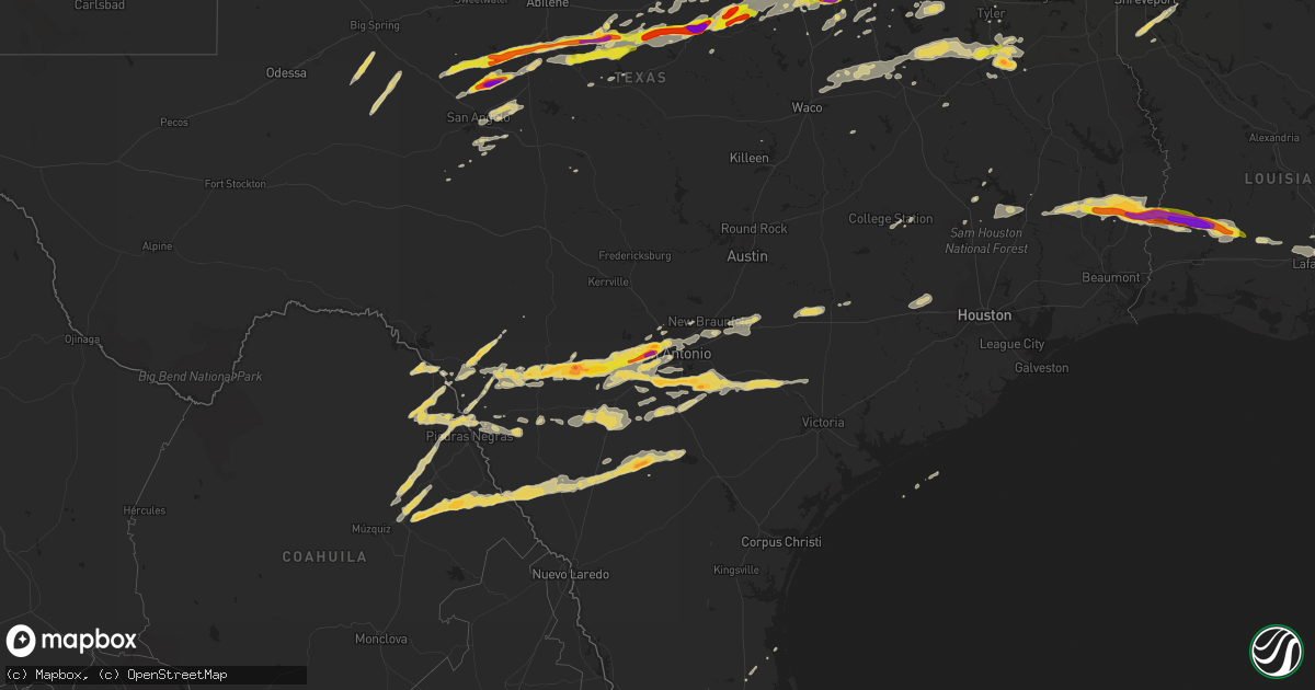
Hail Map on April 24, 2015
Get this storm
April 24 map
$229
one time, instant access
Download today. No call, no setup
Keep the $229
Bought the map and want the full workflow? Apply the entire $229 to a subscription within 7 days. None of it is wasted.
Every map, not just this one
This buys you this map. Subscription and you get every map we run, in the markets you choose from a few cities to whole states to nationwide. Plus real-time alerts the moment a storm fires.
Contact data
Name, contact info, occupancy, even credit band for addresses in the footprint. You go from where it hit to who to call.
Become the source they trust
Unlimited branding weather history reports on demand. You already have the documented answer ready for the property owner, and you are the one who showed up with it.
Property data and RoofTrace estimates
Pull up any address you have got, its value and the exact code rules for that jurisdiction, straight from One Click Code. Then RoofTrace estimates the squares, pitch, and roof value, priced the way you price.
States Impacted by Hail Map on April 24, 2015
Storm reports
Oregon
| Date | Description |
|---|---|
| 04/24/20155:40 PM CDT | Strong wind from shower knocked down a tree in boring... Or. |
| 04/24/20154:45 PM CDT | Strong wind from shower knocked down a tree in boring... Or. Time corrected based on follow-up information from the source of the report. |
Florida
| Date | Description |
|---|---|
| 04/24/20156:50 AM CDT | Large diameter tree was uprooted and caused minor damage to a house. |
Nebraska
| Date | Description |
|---|---|
| 04/24/20156:40 PM CDT | Trained spotter reported golf ball sized hail... With the majority of the hail being quarters and dimes. Hail covered the ground. |
| 04/24/20154:04 PM CDT | 3 to 4 inches of small hail accumulated on united states highway 183 north of taylor.snow plows were deployed to clear the highway. A couple of hailstones reached 1 inc |
| 04/23/20157:30 PM CDT | Hail has completely covered the ground |
Kansas
| Date | Description |
|---|---|
| 04/24/20156:55 PM CDT | A local report indicates 1.00 inch wind near 8 WNW TREGO CENTER |
| 04/24/20156:45 PM CDT | A local report indicates 1.75 inch wind near 3 ESE LUCAS |
| 04/24/20156:40 PM CDT | Emergency manager reports that virtually every car and roof sustained significant hail damage in the town of lucas. All skylights in the middle school were broke out. |
| 04/24/20156:38 PM CDT | Storm survey indicated ef1 damage to the roof and press box at the sylvan grove high school. Tornado was only on the ground for around a quarter mile. |
| 04/24/20156:34 PM CDT | A local report indicates 1.50 inch wind near LUCAS |
| 04/24/20156:33 PM CDT | A local report indicates 1.00 inch wind near 7 SSE COLLYER |
| 04/24/20155:50 PM CDT | Mostly nickel size hail with some quarter size |
| 04/24/20155:46 PM CDT | A local report indicates 80 MPH wind near 5 N RUSSELL |
| 04/24/20155:40 PM CDT | A local report indicates 1.75 inch wind near 7 N RUSSELL |
| 04/24/20155:40 PM CDT | A local report indicates 2.50 inch wind near 8 N RUSSELL |
| 04/24/20155:37 PM CDT | 1 foot diameter tree debris down near 179th and decker road with winds of 70 to 80 mph |
| 04/24/20155:32 PM CDT | A local report indicates 1.75 inch wind near 2 SW PARADISE |
| 04/24/20155:28 PM CDT | Multiple landspout type tornadoes occurring at the same time. |
| 04/24/20155:20 PM CDT | Nws observer reports mostly nickle size hail with some up to the size of quarters. |
| 04/24/20155:14 PM CDT | Brief touchdown. Heavy rain making it hard to see |
| 04/24/20155:13 PM CDT | A local report indicates a tornado near 7 NE EMMERAM |
| 04/24/20155:13 PM CDT | A local report indicates 2.75 inch wind near 7 NNE EMMERAM |
| 04/24/20155:12 PM CDT | A local report indicates a tornado near 11 SE LEOTI |
| 04/24/20155:10 PM CDT | A local report indicates 1.75 inch wind near 3 W WEBSTER STATE PARK |
| 04/24/20155:09 PM CDT | Tornado reported to lasted for 30 minutes and continued into scott county. |
| 04/24/20155:05 PM CDT | A local report indicates a tornado near 6 NE EMMERAM |
| 04/24/20155:04 PM CDT | A local report indicates 1.75 inch wind near 3 N EMMERAM |
| 04/24/20155:04 PM CDT | A local report indicates a tornado near 5 NE EMMERAM |
| 04/24/20155:00 PM CDT | Brief tornado touchdown |
| 04/24/20154:56 PM CDT | A local report indicates a tornado near 5 N CATHERINE |
| 04/24/20154:46 PM CDT | A local report indicates 1.75 inch wind near 4 NW ZURICH |
| 04/24/20154:37 PM CDT | Trained spotter reports penny to dime size hail with a few to the size of a half dollar. |
| 04/24/20154:00 PM CDT | A local report indicates 1.75 inch wind near 5 NNW YOCEMENTO |
| 04/23/201510:54 PM CDT | A local report indicates 1.00 inch wind near OBERLIN |
| 04/23/20158:54 PM CDT | Dime to quarter size hail. |
| 04/23/20157:55 PM CDT | Along i-70 near mile marker 219. Via kwch tv. |
| 04/23/20157:25 PM CDT | A local report indicates 1.00 inch wind near 9 N ARNOLD |
| 04/23/20157:15 PM CDT | Correction to previous report |
| 04/23/20157:15 PM CDT | East side of the lake. Also 35 mph winds. |
Alabama
| Date | Description |
|---|---|
| 04/24/20155:56 AM CDT | 12-15 inch diameter tree uprooted off misty lane near brewton. Time estimated from radar. |
| 04/24/20155:50 AM CDT | Media reports trees and power lines down near the community of brewton. Time estimated from radar. |
| 04/24/20155:45 AM CDT | Broadcast media reports multiple vehicle accident due to trees down in the road on sardine rd near halls creek rd. No injuries reported. Time of downed trees estimated |
South Dakota
| Date | Description |
|---|---|
| 04/24/20156:32 PM CDT | Hail covering the ground. |
| 04/24/20155:53 PM CDT | A local report indicates 1.00 inch wind near 4 ENE CORSICA |
| 04/24/20155:53 PM CDT | A local report indicates 1.00 inch wind near CORSICA |
| 04/24/20155:45 PM CDT | A local report indicates 1.75 inch wind near 4 SSW LOOMIS |
| 04/24/20155:44 PM CDT | A local report indicates 1.00 inch wind near 1 S LOOMIS |
| 04/24/20155:33 PM CDT | Hail covering the ground. |
Colorado
| Date | Description |
|---|---|
| 04/24/20156:00 PM CDT | A local report indicates 1.00 inch wind near 3 ENE ELIZABETH |
Mississippi
| Date | Description |
|---|---|
| 04/24/20153:50 AM CDT | Tree fell on a home and car located at intersection of hwys 503 and 504. No injuries. Time estimated. |
| 04/24/20153:15 AM CDT | Scattered power lines down |
| 04/24/20153:10 AM CDT | Tree down on highway 495 |
| 04/24/20153:10 AM CDT | Nws damage survey found an ef0 tornado with max winds of 75mph...max width of 50yds and path length of 0.9 miles. This tornado began along little-rock rd... Causing a nar (ja |
| 04/24/20152:54 AM CDT | Trees downed across the road along co rd 448 between co rd 525 and ms hwy 19 |
| 04/24/20152:51 AM CDT | Tornado began near the intersection of cr 248/cr 347 and tracked ene through the beatline community crossing ms highway 19 at bethsaida and ended along cr 450. The roof |
| 04/24/20152:50 AM CDT | Trees downed along co rd 347 near co rd 444 |
| 04/24/20152:49 AM CDT | Trees downed along ms hwy 15 |
| 04/24/20152:47 AM CDT | Trees and powerlines down at a few locations in union |
| 04/24/20152:46 AM CDT | Trees downed across ms hwy 485 near co rd 361...causing a multivehicle accident |
| 04/24/20152:30 AM CDT | Trees downed along ms hwy 488. Possible tornado. |
| 04/24/20152:28 AM CDT | Tree downed across ms hwy 35 near twin city |
| 04/24/20152:28 AM CDT | Nws damage survey found an ef1 tornado with max winds of 110mph...max width of 500yds and path length of 3.5 miles. The tornado started just west of hwy 35... Snapping se (ja |
| 04/24/20152:25 AM CDT | Numerous trees down across highway 35 just north of walnut grove |
| 04/24/20152:25 AM CDT | Scattered trees down across northern scott county |
| 04/24/20152:20 AM CDT | Nws damage survey found an ef0 tornado with maximum winds of 75mph...maximum width of 50yds and path length of 0.9 miles. Several trees were snapped and uprooted in a n |
| 04/24/20152:18 AM CDT | Fallen tree crushed camper and car. Wind speed estimated around 60 mph. |
| 04/24/20152:17 AM CDT | Nws damage survey found an ef1 tornado with maximum winds of 105mph...maximum width of 300yds and path length of 2.5 miles. This tornado started just west of highway 25 |
| 04/24/20152:17 AM CDT | Debris in road on ms hwy 25 at ms hwy 13. Possible tornado |
| 04/24/20151:58 AM CDT | Nws damage survey found an ef1 tornado with maximum winds of 95mph...maximum width of 75yds and path length of 1.7 miles. This tornado snapped and uprooted a number of |
| 04/24/20151:58 AM CDT | Tree downed across the natchez trace near milepost 173 |
| 04/24/20151:52 AM CDT | Several shingles blown off a home on the east city of canton |
| 04/24/20151:50 AM CDT | Trees uprooted |
| 04/24/20151:50 AM CDT | A tree fell on a home on w academy st |
| 04/24/20151:47 AM CDT | Observed by private weather station near gluckstadt |
| 04/24/20151:45 AM CDT | Several trees downed in the lake caroline area |
| 04/24/20151:30 AM CDT | Siding damage to a home and a gutter torn off a shop building. |
| 04/24/20151:25 AM CDT | Tree fell on a house on patterson rd. Time estimated. |
| 04/24/20151:15 AM CDT | Several trees downed in satartia and east along highway 433. |
| 04/24/20151:10 AM CDT | Multiple trees downed |
| 04/24/201512:48 AM CDT | Measured on roof of stationary storm chase vehicle |
| 04/24/201512:30 AM CDT | Tree downed along ms hwy 8 near the grenada tallahatchie county line. |
| 04/23/201511:46 PM CDT | Trees were uprooted |
| 04/23/201511:30 PM CDT | Trees were downed and grain silos were damaged |
Oklahoma
| Date | Description |
|---|---|
| 04/24/20156:58 PM CDT | A local report indicates 1.00 inch wind near CALERA |
| 04/24/20151:40 PM CDT | 2 inch tree limbs down. |
Texas
| Date | Description |
|---|---|
| 04/24/20156:55 PM CDT | Trees uprooted |
| 04/24/20156:50 PM CDT | Nickel to quarter size hail reported by border patrol. |
| 04/24/20156:46 PM CDT | Residential roof damage and trees branches downed near new york and arbrook |
| 04/24/20156:46 PM CDT | Near new york and arbrook |
| 04/24/20156:45 PM CDT | Wide spread tree damage... Damage to car ports as well |
| 04/24/20156:42 PM CDT | Us67 ad fm157 |
| 04/24/20156:29 PM CDT | Tree down in street... Large limbs down throughout area |
| 04/24/20156:22 PM CDT | 70-80 mph wind |
| 04/24/20156:15 PM CDT | Tcu area |
| 04/24/20156:14 PM CDT | Hwy377 and tiger trail |
| 04/24/20156:14 PM CDT | A local report indicates 1.00 inch wind near CRESSON |
| 04/24/20156:12 PM CDT | Building damage |
| 04/24/20156:06 PM CDT | 65 to 70 mph at comanche peak |
| 04/24/20156:00 PM CDT | A local report indicates 60 MPH wind near GLEN ROSE |
| 04/24/20155:54 PM CDT | 2 feet diameter tree uprooted |
| 04/24/20155:38 PM CDT | Relayed from the tolar fire department |
| 04/24/20155:34 PM CDT | A local report indicates 1.75 inch wind near STEPHENVILLE |
| 04/24/20155:30 PM CDT | A local report indicates 80 MPH wind near STEPHENVILLE |
| 04/24/20155:17 PM CDT | Trees reported down near de leon |
| 04/24/20155:15 PM CDT | A local report indicates 60 MPH wind near COLEMAN |
| 04/24/20155:10 PM CDT | 70-80 mph winds blew down trees |
| 04/24/20155:08 PM CDT | Trees down mary st and and shady creek |
| 04/24/20154:47 PM CDT | A local report indicates 60 MPH wind near PAINT ROCK |
| 04/24/20154:38 PM CDT | A local report indicates 2.00 inch wind near CROSS PLAINS |
| 04/24/20154:34 PM CDT | A local report indicates 1.00 inch wind near LOWAKE |
| 04/24/20154:30 PM CDT | Numerous trees down across the city. Some trees down on cars. |
| 04/24/20154:23 PM CDT | A local report indicates 1.00 inch wind near ECHO |
| 04/24/20154:22 PM CDT | A local report indicates 70 MPH wind near 3 NE WALL |
| 04/24/20154:18 PM CDT | A local report indicates 1.00 inch wind near MILES |
| 04/24/20154:06 PM CDT | A local report indicates 61 MPH wind near 6 SW SAN ANGELO |
| 04/24/20154:05 PM CDT | A car port was blown 100 feet and severly damaged. Also... Large tree branches were blown down and a slide was damaged. A possible tornado. |
| 04/24/20154:05 PM CDT | Tornado reported at lake coleman. |
| 04/24/20154:05 PM CDT | A local report indicates 61 MPH wind near 6 SW SAN ANGELO |
| 04/24/20153:53 PM CDT | Large tree limbs down on fm 382. |
| 04/24/20153:50 PM CDT | 4 trees down...21 inches in diameter at fm 382 and fm 2647. |
| 04/24/20153:45 PM CDT | Storm chaser reported a tornado on thr ground west of novice. |
| 04/24/20153:45 PM CDT | A local report indicates 70 MPH wind near 5 W NOVICE |
| 04/24/20153:22 PM CDT | A local report indicates 60 MPH wind near WINTERS |
| 04/24/20153:15 PM CDT | A local report indicates 60 MPH wind near 5 NW TENNYSON |
| 04/24/20153:15 PM CDT | A local report indicates 2.75 inch wind near 5 NW TENNYSON |
| 04/24/20153:09 PM CDT | Hail busted numerous vehicle windows. |
| 04/24/20153:08 PM CDT | A local report indicates 1.00 inch wind near WINGATE |
| 04/24/20152:57 PM CDT | A local report indicates 1.75 inch wind near 4 N BRONTE |
| 04/24/20152:38 PM CDT | Residential roofs damaged. |
| 04/24/20152:28 PM CDT | A local report indicates 1.25 inch wind near 8 W ROBERT LEE |
| 04/24/20151:30 PM CDT | Scattered roof damage. Some debris on main street. |
| 04/24/20151:10 PM CDT | Measured by the west tx mesonet near northfield. |
| 04/24/201512:30 PM CDT | Law enforcement reported trees down in call |
| 04/24/201512:20 PM CDT | Nws storm survey determined an ef1 tornado uprooted or snapped numerous trees from ese of call tx to fields la. At least one home had a tree fall on it. |
| 04/24/201512:20 PM CDT | 24 inch diameter tree down. |
| 04/24/201512:20 PM CDT | A local report indicates 60 MPH wind near 7 NW KIRBYVILLE |
| 04/24/201512:05 PM CDT | Tree on top of house. |
| 04/24/201511:58 AM CDT | Nws storm survey determined an ef1 tornado caused damage to trees...homes...and outbuildings from west of kirbyville to the trout creek community of newton texas. |
| 04/24/20156:55 AM CDT | Storm spotter measured 58 gust to 69 mph hwy 99 and franz road. |
| 04/24/20156:40 AM CDT | Minor tree damage in san felipe. |
| 04/24/20155:48 AM CDT | Trees and powerlines reported down |
| 04/24/20155:25 AM CDT | A local report indicates 1.00 inch wind near FLORESVILLE |
| 04/24/20155:20 AM CDT | A local report indicates 1.75 inch wind near 4 WNW FLORESVILLE |
| 04/24/20155:11 AM CDT | Cluster of large trees blown down and damaged sturdy pipe fencing |
| 04/24/20155:00 AM CDT | Barn door blown in with e60 mph winds |
| 04/24/20154:55 AM CDT | A local report indicates 1.25 inch wind near DEVINE |
| 04/24/20154:50 AM CDT | Large e2.5 foot trunk diameter oak tree blown onto home |
| 04/24/20154:49 AM CDT | A local report indicates 1.00 inch wind near 2 SW SEA WORLD |
| 04/24/20154:47 AM CDT | A local report indicates 1.50 inch wind near 2 ESE ROSSVILLE |
| 04/24/20154:45 AM CDT | Nickel to quarter size hail |
| 04/24/20154:45 AM CDT | Several trees knocked down by thunderstorm winds. Relayed by ksat. |
| 04/24/20154:26 AM CDT | 8 to 9 inch diameter tree limbs ripped off and fell onto home along with pea size hail |
| 04/24/20154:20 AM CDT | At i-10 and fredericksburg rd in san antonio. |
| 04/24/20154:15 AM CDT | Near i-410 and bandera in san antonio. |
| 04/24/20153:55 AM CDT | A local report indicates 1.25 inch wind near 3 WSW LEON VALLEY |
| 04/24/20153:54 AM CDT | Trees down... 4-5 trailers flipped at hwy 90 and 173... Doors blown out of ford dealership |
| 04/24/20153:50 AM CDT | Healthy 3 foot diameter mesquite tree snapped off 3 feet above ground level |
| 04/24/20153:50 AM CDT | Healthy 3 foot diameter mesquite tree snapped off 3 feet above ground level |
| 04/24/20153:50 AM CDT | Numerous healthy 4 to 8 inch diameter tree limbs snapped off |
| 04/24/20153:30 AM CDT | Tree limbs greater than 2 inches down in addition to hail. |
| 04/24/20153:15 AM CDT | At texas research park. Small tree limbs down less than 2 inches. 1.00-1.25 inches of rain in 1 hour. |
| 04/23/201511:37 PM CDT | Trained skywarn spotter in los indios reported quarter-size hail. |
| 04/23/201511:35 PM CDT | Public reported medium size tree down on a car in primera via social media. |
| 04/23/201511:35 PM CDT | Harlingen asos at valley international airport reported a 58 mph measured wind gust. |
| 04/23/201511:35 PM CDT | Public reported a measured 60 mph wind gust with a davis instrument in harlingen. |
| 04/23/201511:32 PM CDT | Trained spotter reported 63 kt wind gusts at intersection of 88tx and 1 1/2 mile. |
| 04/23/201511:30 PM CDT | Cameron county so reports tree blown down onto hand road in combes. |
| 04/23/201511:30 PM CDT | Cameron county so reports 2 trees down on fm 506 south of clark road in la feria. |
| 04/23/201511:30 PM CDT | Several powerlines down in the city of edcouch. Time estimated from radar. |
| 04/23/201511:30 PM CDT | Mercedes police department reports 10 to 12 power lines and 15 to 20 trees down across the city of mercedes. |
| 04/23/201511:30 PM CDT | Cameron county so reports utility wires blown down into the road in primera. |
| 04/23/201511:30 PM CDT | Harlingen police department reports two medium-sized trees blown down onto garrett road in harlingen. |
| 04/23/201511:30 PM CDT | San benito police department reports 1 tree blown down onto south sam houston. Also trampoline blown into side of house that caused windows to break on san jacinto driv |
| 04/23/201511:25 PM CDT | Report of road signs blown out of the ground along us 83 near weslaco. |
| 04/23/201511:20 PM CDT | Public reported backyard metal pergola destroyed on the southwest side of weslaco. Time estimated from radar. |
| 04/23/201511:20 PM CDT | Emergency manager of weslaco reported several trees down in the pleasantview area near weslaco. Time estimated from radar. |
| 04/23/201511:20 PM CDT | La feria police department reports tree blown down onto parker road in la feria. |
| 04/23/201511:00 PM CDT | Donna police department reports tree and utility pole damage on numerous streets... Including south victoria road... Main street... Hutto road... And val verde. |
| 04/23/201511:00 PM CDT | Hidalgo county so reports aluminum fence blown over on owassa road in edinburg. |
| 04/23/201511:00 PM CDT | Public reported backyard metal pergola destroyed on the southwest side of weslaco. Time estimated from radar. |
| 04/23/201511:00 PM CDT | Emergency manager of weslaco reported several trees down in the pleasantview area near weslaco. |
| 04/23/201510:40 PM CDT | A few trees down...power lines down |
| 04/23/201510:40 PM CDT | Numerous trees down |
| 04/23/201510:39 PM CDT | Relayed through media. |
| 04/23/201510:23 PM CDT | Large tree down across hwy 175 |
| 04/23/20159:40 PM CDT | A few trees down...power lines down |
| 04/23/20159:31 PM CDT | Tree on house in town |
| 04/23/20159:16 PM CDT | An ef1 tornado touched down 8 miles northwest of linden. Damage consisted of numerous trees uprooted and snapped. Several trees took down powerlines in the area as well |
| 04/23/20159:15 PM CDT | Numerous trees down across the county area |
| 04/23/20159:14 PM CDT | Numerous trees down across the county area |
| 04/23/20159:10 PM CDT | Forty foot crepe myrtle lost the top half of the tree. |
| 04/23/20159:10 PM CDT | Nickel to quarter size hail |
| 04/23/20159:09 PM CDT | A local report indicates 60 MPH wind near UNION GROVE |
| 04/23/20159:06 PM CDT | A local report indicates 1.00 inch wind near DAWSON |
| 04/23/20158:58 PM CDT | An nws storm survey northwest of upshur county determined that the wind damage in and around the union hill community was consistent with that of straight line winds gu |
| 04/23/20158:58 PM CDT | Damage to union hill high school and several homes in the neighborhood. |
| 04/23/20158:43 PM CDT | An ef1 tornado touched down 8.5 miles west southwest of gilmer texas. Damage consisted of numerous trees uprooted and snapped. One tree fell on a house but damage to th |
| 04/23/20158:40 PM CDT | Trees down in white oak |
| 04/23/20158:40 PM CDT | Numerous trees down across the county area |
| 04/23/20158:25 PM CDT | Winds estimated by storm spotter. |
| 04/23/20158:22 PM CDT | A local report indicates 1.00 inch wind near 2 W ARTESIA WELLS |
| 04/23/20157:48 PM CDT | Picture confirms tornado near fm 191 between hwy 277 and hwy 83. Radar indicates tornado likely on ground between 748 and 753 pm. |
| 04/23/20157:05 PM CDT | A local report indicates 1.50 inch wind near 5 N WAXAHACHIE |
| 04/23/20157:04 PM CDT | A local report indicates 1.75 inch wind near WAXAHACHIE |
Arkansas
| Date | Description |
|---|---|
| 04/24/20159:59 AM CDT | A local report indicates 1.00 inch wind near CABOT |
| 04/24/20159:30 AM CDT | A local report indicates 1.75 inch wind near MAUMELLE |
| 04/23/201511:10 PM CDT | Power lines down |
| 04/23/201511:00 PM CDT | Power lines down |
| 04/23/201510:30 PM CDT | Power outages at county road 10 and county road 40 |
| 04/23/201510:30 PM CDT | Trees down on sau campus |
| 04/23/201510:12 PM CDT | Tree down. Car ran into it and people trapped. Fire dept on scene. |
| 04/23/201510:06 PM CDT | A local report indicates 1.00 inch wind near 1 E BRADLEY |
| 04/23/201510:00 PM CDT | Large tree down blocking the highway 1 mile south of sulphur river on hwy 71 south |
| 04/23/20159:15 PM CDT | Numerous trees down in the city of camden. |
| 04/23/20158:05 PM CDT | Power lines down...trees down |
Louisiana
| Date | Description |
|---|---|
| 04/24/20156:15 PM CDT | Trees and powerlines down in paradis and luling. |
| 04/24/20154:37 PM CDT | Several reports from witnesses of a brief tornado touch down. Unsure if damage to 7 trailers was directly related to tornado as images suggest more straightline wind da |
| 04/24/20154:25 PM CDT | Also wind gusts 50 mph. Damage to autos. |
| 04/24/20154:25 PM CDT | Trees down in bayou pigeon and bayou sorrel. Trailer overturned in bayou pigeon area. |
| 04/24/20154:10 PM CDT | Golf ball size hail reported by co-op observer at bayou sorrel lock. Time estimated. |
| 04/24/20153:40 PM CDT | Several public photos of tennis ball to baseball sized hail in catahoula |
| 04/24/20153:37 PM CDT | Public posted photo of baseball sized hail in breaux bridge and parks area |
| 04/24/20153:30 PM CDT | State police reports two overturned 18 wheelers on interstate 10 near milepost 108 |
| 04/24/20153:25 PM CDT | Trained spotter reports estimated 65 mph wind gusts and half dollar size hail |
| 04/24/20153:15 PM CDT | Video of quarter sized hail in breaux bridge |
| 04/24/20151:30 PM CDT | Public reported trees and power lines down |
| 04/24/20151:20 PM CDT | Media shared photo of downed tree in reeves. Time estimated from radar. |
| 04/24/20151:09 PM CDT | Photos of a power pole snapped on 171. Time estimated from radar. |
| 04/24/20151:00 PM CDT | Public shared photo of several large branches down on hwy 110 between singer and longville. Time estimated from radar. |
| 04/24/20151:00 PM CDT | Nws employee reports trees and power lines down along clark rd off of hwy 12. Time estimated from radar. |
| 04/24/201512:56 PM CDT | Emergency manager reports trees down between fields and ragley. Time estimated from radar. |
| 04/24/201512:45 PM CDT | Media relayed report of estimated quarter sized hail in singer |
| 04/24/201512:35 AM CDT | Downed utility lines and snapped utility poles in east carroll parish |
| 04/24/201512:29 AM CDT | Power lines down along hwy 134 |
| 04/24/201512:20 AM CDT | Tree downed across la hwy 17 |
| 04/24/201512:18 AM CDT | Trees and utility poles downed around west carroll parish |
| 04/24/201512:00 AM CDT | A tree and a power line down in mer rouge |
| 04/23/201511:55 PM CDT | Tree down across hwy 593 near collinston |
| 04/23/201511:52 PM CDT | Several trees downed across morehouse parish |
| 04/23/201511:49 PM CDT | A couple trees down |
| 04/23/201511:48 PM CDT | Tree damage occurred three to four miles south of beekman. The most significant damage was along state highway 593 where several large hardwood trees were snapped and u |
| 04/23/201511:10 PM CDT | Trees down... Snapped and uprooted |
| 04/23/201510:40 PM CDT | An ef1 tornado began 7 ese of haynesville and ended 9 wsw of junction city. Damage consisted mainally of uprooted and snapped trees. |
| 04/23/201510:32 PM CDT | Trees down |
| 04/23/201510:30 PM CDT | Power lines down...nickel size hail covering the ground |
| 04/23/201510:30 PM CDT | Power lines down |
| 04/23/201510:03 PM CDT | Tree down on power lines. |
| 04/23/20159:55 PM CDT | Power lines down |
| 04/23/20159:50 PM CDT | Busted out 3 windows of a house |
Cities Impacted by Hail Map on April 24, 2015
- Cotulla, TX
- Tilden, TX
- Fowlerton, TX
- Waldo, KS
- Natoma, KS
- Russell, KS
- Plainville, KS
- Gorham, KS
- Hays, KS
- Bunker Hill, KS
- Catharine, KS
- Victoria, KS
- Lucas, KS
- Luray, KS
- Paradise, KS
- Donaldsonville, LA
- Plaquemine, LA
- Carencro, LA
- Lafayette, LA
- Saint James, LA
- Belle Rose, LA
- Breaux Bridge, LA
- Saint Martinville, LA
- Pierre Part, LA
- Arnaudville, LA
- White Castle, LA
- Grosse Tete, LA
- Gove, KS
- Singer, LA
- Kirbyville, TX
- Bassett, NE
- Wilson, KS
- Lincoln, KS
- Ellsworth, KS
- Dorrance, KS
- Ellis, KS
- Sylvan Grove, KS
- Bowie, TX
- Sunset, TX
- Chico, TX
- Smiley, TX
- Gillett, TX
- Cuero, TX
- Westhoff, TX
- Corsica, SD
- Tyler, TX
- Winona, TX
- Utica, KS
- Arlington, TX
- Grand Prairie, TX
- Stephenville, TX
- Gorman, TX
- Carbon, TX
- Dublin, TX
- De Leon, TX
- Brewster, NE
- Taylor, NE
- Floresville, TX
- Elmendorf, TX
- Poteet, TX
- Somerset, TX
- Von Ormy, TX
- San Antonio, TX
- Ransom, KS
- Wakeeney, KS
- Wortham, TX
- Whitehouse, TX
- Palestine, TX
- Athens, TX
- Purdon, TX
- Jacksonville, TX
- Dawson, TX
- Mount Calm, TX
- Axtell, TX
- Hubbard, TX
- Troup, TX
- Montalba, TX
- Streetman, TX
- Richland, TX
- Henderson, TX
- Bullard, TX
- Malakoff, TX
- Fairfield, TX
- Larue, TX
- Rusk, TX
- Tennessee Colony, TX
- Kerens, TX
- Coolidge, TX
- Mexia, TX
- Penelope, TX
- Frankston, TX
- Pawnee City, NE
- Axtell, KS
- Burchard, NE
- Lyford, TX
- Spearsville, LA
- Castroville, TX
- Robert Lee, TX
- Bronte, TX
- Miles, TX
- Paint Rock, TX
- Rowena, TX
- San Angelo, TX
- Mereta, TX
- Laredo, TX
- Fred, TX
- Merryville, LA
- Spurger, TX
- Newton, TX
- Hillister, TX
- Call, TX
- Warren, TX
- Bon Wier, TX
- Woodville, TX
- Santa Anna, TX
- Collyer, KS
- Hico, TX
- Venus, TX
- Saint Francis, KS
- Midlothian, TX
- Alvarado, TX
- Mansfield, TX
- Mitchell, SD
- Bridgewater, SD
- Waxahachie, TX
- Red Oak, TX
- Dunning, NE
- Purdum, NE
- Quinter, KS
- Weatherford, TX
- Granbury, TX
- Tribune, KS
- Barry, TX
- Bluff Dale, TX
- Tolar, TX
- Charlotte, TX
- Bigfoot, TX
- Kit Carson, CO
- Brookshire, TX
- Yorktown, TX
- Glen Rose, TX
- Desdemona, TX
- Comanche, TX
- Huntsville, TX
- Ida, LA
- Vivian, LA
- Hosston, LA
- Palco, KS
- Stockton, KS
- Logan, KS
- Phillipsburg, KS
- Van, TX
- Grand Saline, TX
- Baker, FL
- Flatonia, TX
- Muldoon, TX
- Kinder, LA
- Reeves, LA
- Dallas, TX
- Addison, TX
- Carrollton, TX
- Como, TX
- Yantis, TX
- Colton, SD
- Humboldt, SD
- Hartford, SD
- Great Bend, KS
- Cotton Valley, LA
- Minden, LA
- Benton, LA
- Haughton, LA
- La Feria, TX
- San Benito, TX
- Burwell, NE
- Devine, TX
- Lytle, TX
- Natalia, TX
- Hondo, TX
- Winters, TX
- Scott City, KS
- Parkston, SD
- Dilley, TX
- Pearsall, TX
- Batesville, TX
- Crystal City, TX
- Helotes, TX
- Brady, NE
- Maxwell, NE
- Stapleton, NE
- Coldspring, TX
- Goldsboro, TX
- Ovalo, TX
- Wingate, TX
- Novice, TX
- Cross Plains, TX
- Lawn, TX
- Baird, TX
- Rising Star, TX
- Cisco, TX
- Clyde, TX
- Pleasanton, TX
- Uvalde, TX
- Maumelle, AR
- Sabinal, TX
- Spivey, KS
- Zenda, KS
- Little Rock, AR
- North Little Rock, AR
- Opelousas, LA
- Sunset, LA
- Armour, SD
- Big Lake, TX
- Sterling City, TX
- Garden City, TX
- Plain Dealing, LA
- Bradley, AR
- Kingsbury, TX
- Eagle Pass, TX
- Quemado, TX
- Ogallah, KS
- Grinnell, KS
- Mineola, TX
- Quitman, TX
- Winnsboro, TX
- Beverly, KS
- Tescott, KS
- Minneapolis, KS
- May, TX
- Burkett, TX
- Coleman, TX
- Brownwood, TX
- La Pryor, TX
- Weslaco, TX
- Hawkins, TX
- Jefferson, TX
- Harleton, TX
- Daingerfield, TX
- Avinger, TX
- Ore City, TX
- Omaha, TX
- Gilmer, TX
- Big Sandy, TX
- Pittsburg, TX
- Diana, TX
- Knippa, TX
- Brackettville, TX
- Eustace, TX
- Santa Rosa, TX
- Burlington, CO
- Fedora, SD
- Mingus, TX
- Ranger, TX
- Marion, LA
- Bastrop, LA
- Ogallala, NE
- Mabank, TX
- Longville, LA
- Ragley, LA
- Dequincy, LA
- Menno, SD
- Scotland, SD
- Olivet, SD
- Kaycee, WY
- Bivins, TX
- Kingston, OK
- Hendrix, OK
- Durant, OK
- Colbert, OK
- Calera, OK
- Mead, OK
- Branch, LA
- Rayne, LA
- Plattenville, LA
- Napoleonville, LA
- Convent, LA
- Vacherie, LA
- Jeanerette, LA
- Scott, LA
- Church Point, LA
- Palmer, TX
- Lancaster, TX
- Ferris, TX
- Rio Medina, TX
- D Hanis, TX
- Kingman, KS
- Quinlan, TX
- Lone Oak, TX
- Point, TX
- Linn, KS
- Calliham, TX
- Lexington, MS
- Italy, TX
- Bentonia, MS
- Canova, SD
- Salem, SD
- Morganville, KS
- Clifton, KS
- Clyde, KS
- New Waverly, TX
- Hope, AR
- Fulton, SD
- Brashear, TX
- Cumby, TX
- Emory, TX
- Sulphur Springs, TX
- Marienthal, KS
- Leoti, KS
- Ennis, TX
- Park, KS
- McDonald, KS
- Burns, KS
- Laurel Hill, FL
- Shreveport, LA
- Gloster, LA
- Frierson, LA
- Stonewall, LA
- Elm Grove, LA
- Summerfield, LA
- Taylor, AR
- Yazoo City, MS
- Mercedes, TX
- Wichita, KS
- Joshua, TX
- Talpa, TX
- Keene, TX
- Cedar Hill, TX
- Crowley, TX
- Nemo, TX
- Cleburne, TX
- Burleson, TX
- Godley, TX
- Rainbow, TX
- Cresson, TX
- Fort Worth, TX
- Basile, LA
- Jennings, LA
- Eastland, TX
- Bonita, LA
- Aledo, TX
- Clay Center, KS
- Hoxie, KS
- Keatchie, LA
- Grand Cane, LA
- Stockville, NE
- Ballinger, TX
- Des Allemands, LA
- Ama, LA
- Sterlington, LA
- Christoval, TX
- Farmerville, LA
- Monroe, LA
- Downsville, LA
- Paradis, LA
- Hahnville, LA
- Thibodaux, LA
- Edgard, LA
- Boutte, LA
- Haynesville, LA
- Ben Wheeler, TX
- Canton, TX
- Linden, TX
- Rodessa, LA
- Gilliam, LA
- Belcher, LA
- Doddridge, AR
- Lipan, TX
- New Braunfels, TX
- McQueeney, TX
- Seguin, TX
- Marion, TX
- Norris, SD
- Long Valley, SD
- Asherton, TX
- Bernice, LA
- Lafitte, LA
- Port Sulphur, LA
- Braithwaite, LA
- Belle Chasse, LA
- Atlanta, TX
- Jbsa Lackland, TX
- Norton, TX
- Wessington Springs, SD
- Tryon, NE
- Greenleaf, KS
- Whitesboro, TX
- Letcher, SD
- Longford, KS
- Wakefield, KS
- Mount Vernon, SD
- Artesian, SD
- Sharon Springs, KS
- Weskan, KS
- Vancourt, TX
- Converse, TX
- Jbsa Randolph, TX
- Universal City, TX
- College Station, TX
- Katy, TX
- Jourdanton, TX
- Marietta, TX
- Naples, TX
- Morland, KS
- Pioneer, LA
- Hutchinson, KS
- Pretty Prairie, KS
- Wills Point, TX
- Atascosa, TX
- La Coste, TX
- Stockdale, TX
- Falls City, TX
- La Vernia, TX
- Mico, TX
- Yancey, TX
- Livingston, TX
- Jasper, TX
- Ethan, SD
- Nashville, KS
- Prescott, AR
- Rosston, AR
- Idalia, CO
- Fruitvale, TX
- Edgewood, TX
- Canistota, SD
- Carrizo Springs, TX
- North Platte, NE
- Itasca, TX
- Melvin, TX
- Luling, TX
- Anselmo, NE
- Hughes Springs, TX
- Donna, TX
- Greenville, AL
- Emmet, AR
- Trinity, TX
- Yoakum, TX
- Stratton, CO
- Eldorado, TX
- Larned, KS
- Texarkana, TX
- Nash, TX
- Camden, AR
- Astoria, SD
- Sealy, TX
- Bennington, KS
- Brookville, KS
- Homer, LA
- Winfred, SD
- Terrell, TX
- Lisbon, LA
- Grainfield, KS
- Jennings, KS
- Plankinton, SD
- Arnold, NE
- Emery, SD
- Macksville, KS
- Marysville, KS
- Brewton, AL
- Jay, FL
- St John, KS
- Eunice, LA
- Iota, LA
- Fulton, AR
- Palmer, KS
- Lone Star, TX
- Forreston, TX
- Milford, TX
- Pottsboro, TX
- Bokchito, OK
- Cartwright, OK
- Denison, TX
- Catarina, TX
- Carlsbad, TX
- Del Rio, TX
- Raymondville, TX
- Claflin, KS
- Oakley, KS
- Washington, KS
- Henrietta, TX
- Aurora, KS
- Mer Rouge, LA
- Kaufman, TX
- Goodfellow Afb, TX
- Corsicana, TX
- Rice, TX
- Alexandria, SD
- Childress, TX
- Marrero, LA
- Barataria, LA
- Cunningham, KS
- Harlingen, TX
- Steinauer, NE
- Culbertson, NE
- La Grange, TX
- Oberlin, KS
- Waller, TX
- Forest Home, AL
- Wray, CO
- Brady, TX
- Jacksboro, TX
- Moore, TX
- Sutherland Springs, TX
- Cibolo, TX
- Poth, TX
- Schertz, TX
- Jbsa Ft Sam Houston, TX
- Milton, FL
- Lewisville, AR
- Lewis, KS
- Moorefield, NE
- Arthur City, TX
- Powderly, TX
- Laneville, TX
- Reklaw, TX
- Thedford, NE
- Springhill, LA
- Oil City, LA
- Shongaloo, LA
- Emerson, AR
- Pointblank, TX
- Sarepta, LA
- Santo, TX
- Haven, KS
- Satartia, MS
- Bangs, TX
- Mansfield, LA
- Amelia, NE
- Barnes, KS
- Hanover, KS
- Table Rock, NE
- Bloomburg, TX
- Wellfleet, NE
- Lindale, TX
- Axis, AL
- Saraland, AL
- Chunchula, AL
- Millsap, TX
- Chidester, AR
- Buckner, AR
- Kemp, TX
- Roanoke, TX
- Oak Grove, LA
- Woonsocket, SD
- Anderson, TX
- Scurry, TX
- Fayetteville, TX
- Ellinger, TX
- Brandt, SD
- Lillian, TX
- Kosse, TX
- Doyline, LA
- Shepherd, MT
- Broadview, MT
- Gordon, TX
- Miltonvale, KS
- Delphos, KS
- Atwood, KS
- Dimock, SD
- Humboldt, NE
- Waelder, TX
- Schulenburg, TX
- Duncanville, TX
- Freeman, SD
- Long Pine, NE
- Elton, LA