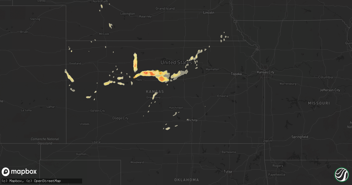
Hail Map in Kansas on April 24, 2015
Get this storm
April 24 map
$229
one time, instant access
Download today. No call, no setup
Keep the $229
Bought the map and want the full workflow? Apply the entire $229 to a subscription within 7 days. None of it is wasted.
Every map, not just this one
This buys you this map. Subscription and you get every map we run, in the markets you choose from a few cities to whole states to nationwide. Plus real-time alerts the moment a storm fires.
Contact data
Name, contact info, occupancy, even credit band for addresses in the footprint. You go from where it hit to who to call.
Become the source they trust
Unlimited branding weather history reports on demand. You already have the documented answer ready for the property owner, and you are the one who showed up with it.
Property data and RoofTrace estimates
Pull up any address you have got, its value and the exact code rules for that jurisdiction, straight from One Click Code. Then RoofTrace estimates the squares, pitch, and roof value, priced the way you price.
Storm reports in Kansas
Kansas
| Date | Description |
|---|---|
| 04/24/20156:55 PM CDT | A local report indicates 1.00 inch wind near 8 WNW TREGO CENTER |
| 04/24/20156:45 PM CDT | A local report indicates 1.75 inch wind near 3 ESE LUCAS |
| 04/24/20156:40 PM CDT | Emergency manager reports that virtually every car and roof sustained significant hail damage in the town of lucas. All skylights in the middle school were broke out. |
| 04/24/20156:38 PM CDT | Storm survey indicated ef1 damage to the roof and press box at the sylvan grove high school. Tornado was only on the ground for around a quarter mile. |
| 04/24/20156:34 PM CDT | A local report indicates 1.50 inch wind near LUCAS |
| 04/24/20156:33 PM CDT | A local report indicates 1.00 inch wind near 7 SSE COLLYER |
| 04/24/20155:50 PM CDT | Mostly nickel size hail with some quarter size |
| 04/24/20155:46 PM CDT | A local report indicates 80 MPH wind near 5 N RUSSELL |
| 04/24/20155:40 PM CDT | A local report indicates 2.50 inch wind near 8 N RUSSELL |
| 04/24/20155:40 PM CDT | A local report indicates 1.75 inch wind near 7 N RUSSELL |
| 04/24/20155:37 PM CDT | 1 foot diameter tree debris down near 179th and decker road with winds of 70 to 80 mph |
| 04/24/20155:32 PM CDT | A local report indicates 1.75 inch wind near 2 SW PARADISE |
| 04/24/20155:28 PM CDT | Multiple landspout type tornadoes occurring at the same time. |
| 04/24/20155:20 PM CDT | Nws observer reports mostly nickle size hail with some up to the size of quarters. |
| 04/24/20155:14 PM CDT | Brief touchdown. Heavy rain making it hard to see |
| 04/24/20155:13 PM CDT | A local report indicates a tornado near 7 NE EMMERAM |
| 04/24/20155:13 PM CDT | A local report indicates 2.75 inch wind near 7 NNE EMMERAM |
| 04/24/20155:12 PM CDT | A local report indicates a tornado near 11 SE LEOTI |
| 04/24/20155:10 PM CDT | A local report indicates 1.75 inch wind near 3 W WEBSTER STATE PARK |
| 04/24/20155:09 PM CDT | Tornado reported to lasted for 30 minutes and continued into scott county. |
| 04/24/20155:05 PM CDT | A local report indicates a tornado near 6 NE EMMERAM |
| 04/24/20155:04 PM CDT | A local report indicates a tornado near 5 NE EMMERAM |
| 04/24/20155:04 PM CDT | A local report indicates 1.75 inch wind near 3 N EMMERAM |
| 04/24/20155:00 PM CDT | Brief tornado touchdown |
| 04/24/20154:56 PM CDT | A local report indicates a tornado near 5 N CATHERINE |
| 04/24/20154:46 PM CDT | A local report indicates 1.75 inch wind near 4 NW ZURICH |
| 04/24/20154:37 PM CDT | Trained spotter reports penny to dime size hail with a few to the size of a half dollar. |
| 04/24/20154:00 PM CDT | A local report indicates 1.75 inch wind near 5 NNW YOCEMENTO |
| 04/23/201510:54 PM CDT | A local report indicates 1.00 inch wind near OBERLIN |
| 04/23/20158:54 PM CDT | Dime to quarter size hail. |
| 04/23/20157:55 PM CDT | Along i-70 near mile marker 219. Via kwch tv. |
| 04/23/20157:25 PM CDT | A local report indicates 1.00 inch wind near 9 N ARNOLD |
| 04/23/20157:15 PM CDT | East side of the lake. Also 35 mph winds. |
| 04/23/20157:15 PM CDT | Correction to previous report |
All States Impacted by Hail Map on April 24, 2015
Cities Impacted by Hail Map on April 24, 2015
- Cotulla, TX
- Tilden, TX
- Fowlerton, TX
- Waldo, KS
- Natoma, KS
- Russell, KS
- Plainville, KS
- Gorham, KS
- Hays, KS
- Bunker Hill, KS
- Catharine, KS
- Victoria, KS
- Lucas, KS
- Luray, KS
- Paradise, KS
- Donaldsonville, LA
- Plaquemine, LA
- Carencro, LA
- Lafayette, LA
- Saint James, LA
- Belle Rose, LA
- Breaux Bridge, LA
- Saint Martinville, LA
- Pierre Part, LA
- Arnaudville, LA
- White Castle, LA
- Grosse Tete, LA
- Gove, KS
- Singer, LA
- Kirbyville, TX
- Bassett, NE
- Wilson, KS
- Lincoln, KS
- Ellsworth, KS
- Dorrance, KS
- Ellis, KS
- Sylvan Grove, KS
- Bowie, TX
- Sunset, TX
- Chico, TX
- Smiley, TX
- Gillett, TX
- Cuero, TX
- Westhoff, TX
- Corsica, SD
- Tyler, TX
- Winona, TX
- Utica, KS
- Arlington, TX
- Grand Prairie, TX
- Stephenville, TX
- Gorman, TX
- Carbon, TX
- Dublin, TX
- De Leon, TX
- Brewster, NE
- Taylor, NE
- Floresville, TX
- Elmendorf, TX
- Poteet, TX
- Somerset, TX
- Von Ormy, TX
- San Antonio, TX
- Ransom, KS
- Wakeeney, KS
- Wortham, TX
- Whitehouse, TX
- Palestine, TX
- Athens, TX
- Purdon, TX
- Jacksonville, TX
- Dawson, TX
- Mount Calm, TX
- Axtell, TX
- Hubbard, TX
- Troup, TX
- Montalba, TX
- Streetman, TX
- Richland, TX
- Henderson, TX
- Bullard, TX
- Malakoff, TX
- Fairfield, TX
- Larue, TX
- Rusk, TX
- Tennessee Colony, TX
- Kerens, TX
- Coolidge, TX
- Mexia, TX
- Penelope, TX
- Frankston, TX
- Pawnee City, NE
- Axtell, KS
- Burchard, NE
- Lyford, TX
- Spearsville, LA
- Castroville, TX
- Robert Lee, TX
- Bronte, TX
- Miles, TX
- Paint Rock, TX
- Rowena, TX
- San Angelo, TX
- Mereta, TX
- Laredo, TX
- Fred, TX
- Merryville, LA
- Spurger, TX
- Newton, TX
- Hillister, TX
- Call, TX
- Warren, TX
- Bon Wier, TX
- Woodville, TX
- Santa Anna, TX
- Collyer, KS
- Hico, TX
- Venus, TX
- Saint Francis, KS
- Midlothian, TX
- Alvarado, TX
- Mansfield, TX
- Mitchell, SD
- Bridgewater, SD
- Waxahachie, TX
- Red Oak, TX
- Dunning, NE
- Purdum, NE
- Quinter, KS
- Weatherford, TX
- Granbury, TX
- Tribune, KS
- Barry, TX
- Bluff Dale, TX
- Tolar, TX
- Charlotte, TX
- Bigfoot, TX
- Kit Carson, CO
- Brookshire, TX
- Yorktown, TX
- Glen Rose, TX
- Desdemona, TX
- Comanche, TX
- Huntsville, TX
- Ida, LA
- Vivian, LA
- Hosston, LA
- Palco, KS
- Stockton, KS
- Logan, KS
- Phillipsburg, KS
- Van, TX
- Grand Saline, TX
- Baker, FL
- Flatonia, TX
- Muldoon, TX
- Kinder, LA
- Reeves, LA
- Dallas, TX
- Addison, TX
- Carrollton, TX
- Como, TX
- Yantis, TX
- Colton, SD
- Humboldt, SD
- Hartford, SD
- Great Bend, KS
- Cotton Valley, LA
- Minden, LA
- Benton, LA
- Haughton, LA
- La Feria, TX
- San Benito, TX
- Burwell, NE
- Devine, TX
- Lytle, TX
- Natalia, TX
- Hondo, TX
- Winters, TX
- Scott City, KS
- Parkston, SD
- Dilley, TX
- Pearsall, TX
- Batesville, TX
- Crystal City, TX
- Helotes, TX
- Brady, NE
- Maxwell, NE
- Stapleton, NE
- Coldspring, TX
- Goldsboro, TX
- Ovalo, TX
- Wingate, TX
- Novice, TX
- Cross Plains, TX
- Lawn, TX
- Baird, TX
- Rising Star, TX
- Cisco, TX
- Clyde, TX
- Pleasanton, TX
- Uvalde, TX
- Maumelle, AR
- Sabinal, TX
- Spivey, KS
- Zenda, KS
- Little Rock, AR
- North Little Rock, AR
- Opelousas, LA
- Sunset, LA
- Armour, SD
- Big Lake, TX
- Sterling City, TX
- Garden City, TX
- Plain Dealing, LA
- Bradley, AR
- Kingsbury, TX
- Eagle Pass, TX
- Quemado, TX
- Ogallah, KS
- Grinnell, KS
- Mineola, TX
- Quitman, TX
- Winnsboro, TX
- Beverly, KS
- Tescott, KS
- Minneapolis, KS
- May, TX
- Burkett, TX
- Coleman, TX
- Brownwood, TX
- La Pryor, TX
- Weslaco, TX
- Hawkins, TX
- Jefferson, TX
- Harleton, TX
- Daingerfield, TX
- Avinger, TX
- Ore City, TX
- Omaha, TX
- Gilmer, TX
- Big Sandy, TX
- Pittsburg, TX
- Diana, TX
- Knippa, TX
- Brackettville, TX
- Eustace, TX
- Santa Rosa, TX
- Burlington, CO
- Fedora, SD
- Mingus, TX
- Ranger, TX
- Marion, LA
- Bastrop, LA
- Ogallala, NE
- Mabank, TX
- Longville, LA
- Ragley, LA
- Dequincy, LA
- Menno, SD
- Scotland, SD
- Olivet, SD
- Kaycee, WY
- Bivins, TX
- Kingston, OK
- Hendrix, OK
- Durant, OK
- Colbert, OK
- Calera, OK
- Mead, OK
- Branch, LA
- Rayne, LA
- Plattenville, LA
- Napoleonville, LA
- Convent, LA
- Vacherie, LA
- Jeanerette, LA
- Scott, LA
- Church Point, LA
- Palmer, TX
- Lancaster, TX
- Ferris, TX
- Rio Medina, TX
- D Hanis, TX
- Kingman, KS
- Quinlan, TX
- Lone Oak, TX
- Point, TX
- Linn, KS
- Calliham, TX
- Lexington, MS
- Italy, TX
- Bentonia, MS
- Canova, SD
- Salem, SD
- Morganville, KS
- Clifton, KS
- Clyde, KS
- New Waverly, TX
- Hope, AR
- Fulton, SD
- Brashear, TX
- Cumby, TX
- Emory, TX
- Sulphur Springs, TX
- Marienthal, KS
- Leoti, KS
- Ennis, TX
- Park, KS
- McDonald, KS
- Burns, KS
- Laurel Hill, FL
- Shreveport, LA
- Gloster, LA
- Frierson, LA
- Stonewall, LA
- Elm Grove, LA
- Summerfield, LA
- Taylor, AR
- Yazoo City, MS
- Mercedes, TX
- Wichita, KS
- Joshua, TX
- Talpa, TX
- Keene, TX
- Cedar Hill, TX
- Crowley, TX
- Nemo, TX
- Cleburne, TX
- Burleson, TX
- Godley, TX
- Rainbow, TX
- Cresson, TX
- Fort Worth, TX
- Basile, LA
- Jennings, LA
- Eastland, TX
- Bonita, LA
- Aledo, TX
- Clay Center, KS
- Hoxie, KS
- Keatchie, LA
- Grand Cane, LA
- Stockville, NE
- Ballinger, TX
- Des Allemands, LA
- Ama, LA
- Sterlington, LA
- Christoval, TX
- Farmerville, LA
- Monroe, LA
- Downsville, LA
- Paradis, LA
- Hahnville, LA
- Thibodaux, LA
- Edgard, LA
- Boutte, LA
- Haynesville, LA
- Ben Wheeler, TX
- Canton, TX
- Linden, TX
- Rodessa, LA
- Gilliam, LA
- Belcher, LA
- Doddridge, AR
- Lipan, TX
- New Braunfels, TX
- McQueeney, TX
- Seguin, TX
- Marion, TX
- Norris, SD
- Long Valley, SD
- Asherton, TX
- Bernice, LA
- Lafitte, LA
- Port Sulphur, LA
- Braithwaite, LA
- Belle Chasse, LA
- Atlanta, TX
- Jbsa Lackland, TX
- Norton, TX
- Wessington Springs, SD
- Tryon, NE
- Greenleaf, KS
- Whitesboro, TX
- Letcher, SD
- Longford, KS
- Wakefield, KS
- Mount Vernon, SD
- Artesian, SD
- Sharon Springs, KS
- Weskan, KS
- Vancourt, TX
- Converse, TX
- Jbsa Randolph, TX
- Universal City, TX
- College Station, TX
- Katy, TX
- Jourdanton, TX
- Marietta, TX
- Naples, TX
- Morland, KS
- Pioneer, LA
- Hutchinson, KS
- Pretty Prairie, KS
- Wills Point, TX
- Atascosa, TX
- La Coste, TX
- Stockdale, TX
- Falls City, TX
- La Vernia, TX
- Mico, TX
- Yancey, TX
- Livingston, TX
- Jasper, TX
- Ethan, SD
- Nashville, KS
- Prescott, AR
- Rosston, AR
- Idalia, CO
- Fruitvale, TX
- Edgewood, TX
- Canistota, SD
- Carrizo Springs, TX
- North Platte, NE
- Itasca, TX
- Melvin, TX
- Luling, TX
- Anselmo, NE
- Hughes Springs, TX
- Donna, TX
- Greenville, AL
- Emmet, AR
- Trinity, TX
- Yoakum, TX
- Stratton, CO
- Eldorado, TX
- Larned, KS
- Texarkana, TX
- Nash, TX
- Camden, AR
- Astoria, SD
- Sealy, TX
- Bennington, KS
- Brookville, KS
- Homer, LA
- Winfred, SD
- Terrell, TX
- Lisbon, LA
- Grainfield, KS
- Jennings, KS
- Plankinton, SD
- Arnold, NE
- Emery, SD
- Macksville, KS
- Marysville, KS
- Brewton, AL
- Jay, FL
- St John, KS
- Eunice, LA
- Iota, LA
- Fulton, AR
- Palmer, KS
- Lone Star, TX
- Forreston, TX
- Milford, TX
- Pottsboro, TX
- Bokchito, OK
- Cartwright, OK
- Denison, TX
- Catarina, TX
- Carlsbad, TX
- Del Rio, TX
- Raymondville, TX
- Claflin, KS
- Oakley, KS
- Washington, KS
- Henrietta, TX
- Aurora, KS
- Mer Rouge, LA
- Kaufman, TX
- Goodfellow Afb, TX
- Corsicana, TX
- Rice, TX
- Alexandria, SD
- Childress, TX
- Marrero, LA
- Barataria, LA
- Cunningham, KS
- Harlingen, TX
- Steinauer, NE
- Culbertson, NE
- La Grange, TX
- Oberlin, KS
- Waller, TX
- Forest Home, AL
- Wray, CO
- Brady, TX
- Jacksboro, TX
- Moore, TX
- Sutherland Springs, TX
- Cibolo, TX
- Poth, TX
- Schertz, TX
- Jbsa Ft Sam Houston, TX
- Milton, FL
- Lewisville, AR
- Lewis, KS
- Moorefield, NE
- Arthur City, TX
- Powderly, TX
- Laneville, TX
- Reklaw, TX
- Thedford, NE
- Springhill, LA
- Oil City, LA
- Shongaloo, LA
- Emerson, AR
- Pointblank, TX
- Sarepta, LA
- Santo, TX
- Haven, KS
- Satartia, MS
- Bangs, TX
- Mansfield, LA
- Amelia, NE
- Barnes, KS
- Hanover, KS
- Table Rock, NE
- Bloomburg, TX
- Wellfleet, NE
- Lindale, TX
- Axis, AL
- Saraland, AL
- Chunchula, AL
- Millsap, TX
- Chidester, AR
- Buckner, AR
- Kemp, TX
- Roanoke, TX
- Oak Grove, LA
- Woonsocket, SD
- Anderson, TX
- Scurry, TX
- Fayetteville, TX
- Ellinger, TX
- Brandt, SD
- Lillian, TX
- Kosse, TX
- Doyline, LA
- Shepherd, MT
- Broadview, MT
- Gordon, TX
- Miltonvale, KS
- Delphos, KS
- Atwood, KS
- Dimock, SD
- Humboldt, NE
- Waelder, TX
- Schulenburg, TX
- Duncanville, TX
- Freeman, SD
- Long Pine, NE
- Elton, LA


