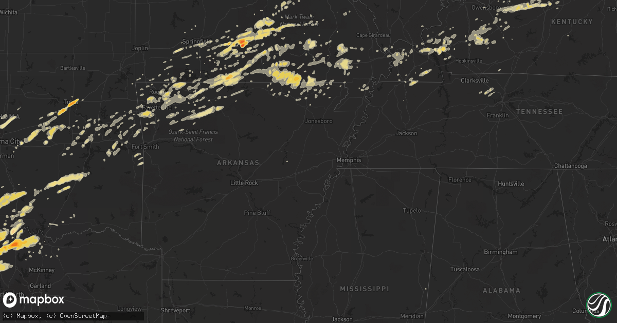
Hail Map in Texas on April 23, 2011
Get this storm
April 23 map
$229
one time, instant access
Download today. No call, no setup
Keep the $229
Bought the map and want the full workflow? Apply the entire $229 to a subscription within 7 days. None of it is wasted.
Every map, not just this one
This buys you this map. Subscription and you get every map we run, in the markets you choose from a few cities to whole states to nationwide. Plus real-time alerts the moment a storm fires.
Contact data
Name, contact info, occupancy, even credit band for addresses in the footprint. You go from where it hit to who to call.
Become the source they trust
Unlimited branding weather history reports on demand. You already have the documented answer ready for the property owner, and you are the one who showed up with it.
Property data and RoofTrace estimates
Pull up any address you have got, its value and the exact code rules for that jurisdiction, straight from One Click Code. Then RoofTrace estimates the squares, pitch, and roof value, priced the way you price.
Storm reports in Texas
Texas
| Date | Description |
|---|---|
| 04/23/20116:49 PM CDT | Quarter size hail 2 southwest of st. Jo |
| 04/23/20116:45 PM CDT | Ping pong ball size hail in callisburg |
| 04/23/20116:35 PM CDT | Orange size hail 2 north of gainesville |
| 04/23/20116:18 PM CDT | Half dollar size hail in sunset |
| 04/23/20116:06 PM CDT | Golfball size hail in gainesville |
| 04/23/20116:05 PM CDT | Tennis ball hail reported 4 miles nne of lindsay |
| 04/23/20116:03 PM CDT | Baseball hail in lindsay |
| 04/23/20116:02 PM CDT | Golfball hail 2 miles nw of gainesville |
| 04/23/20115:58 PM CDT | Quarter size hail in gainesville |
| 04/23/20115:57 PM CDT | Quarter hail reported on the west side of palo pinto |
| 04/23/20115:54 PM CDT | Baseball hail in lindsay |
| 04/23/20115:41 PM CDT | A local report indicates 1.00 inch wind near 4 S HASKELL |
| 04/23/20115:31 PM CDT | Half dollar hail 4 se of myra |
| 04/23/20115:31 PM CDT | Quarter size hail reported in lueders. |
| 04/23/20115:24 PM CDT | A local report indicates 1.50 inch wind near 2 W BROWNWOOD |
| 04/23/20115:16 PM CDT | Quarter size hail 3 miles south of muenster |
| 04/23/20115:06 PM CDT | Golfball hail 4 ssw of muenster |
| 04/23/20114:50 PM CDT | Baseball size hail in truby |
| 04/23/20114:45 PM CDT | Half dollar hail in prairie point |
| 04/23/20114:43 PM CDT | Forestburg vfd reported golfball hail 2 miles ne of forestburg |
| 04/22/201111:48 PM CDT | Addison asos reports 58 mph wind gust |
| 04/22/201111:37 PM CDT | 60 mph wind gust in plano at the intersection of coit rd. And parker rd. |
| 04/22/201111:27 PM CDT | 58 mph wind gust at dfw airport |
| 04/22/201111:25 PM CDT | Delayed report of golfball sized hail near burkburnett. |
| 04/22/201111:15 PM CDT | Quarter sized hail reported southeast of burkburnett near the intersection of 240 and bailey road. |
| 04/22/201111:14 PM CDT | Numerous power lines and 3 inch tree limbs down in grapevine....colleyville and bedford |
| 04/22/201110:47 PM CDT | 68 mph wind gust reported at alliance airport asos |
| 04/22/201110:45 PM CDT | A local report indicates 1.00 inch wind near CASHION COMMUNITY |
| 04/22/201110:40 PM CDT | A local report indicates 1.00 inch wind near ELECTRA |
| 04/22/201110:20 PM CDT | Golfball size hail in comanche |
| 04/22/201110:10 PM CDT | Golfball to baseball size hail 1 mile west of sidney |
| 04/22/201110:06 PM CDT | Baseball size hail just west of beattie |
| 04/22/20119:55 PM CDT | Sherman asos |
| 04/22/20119:50 PM CDT | Quarter hail in mineral wells |
| 04/22/20119:25 PM CDT | Quarter size hail in dublin |
| 04/22/20119:24 PM CDT | A local report indicates 1.25 inch wind near DUBLIN |
| 04/22/20119:03 PM CDT | A local report indicates 1.75 inch wind near MAY |
| 04/22/20119:00 PM CDT | Golfball size hail in duster |
| 04/22/20118:26 PM CDT | 67 mph wind gust reported by denton asos site kdto |
| 04/22/20118:13 PM CDT | Brief tornado 2 miles north northwest of sidney |
| 04/22/20118:11 PM CDT | Chimney blown off a house on fm 1202...just west of outlet mall |
| 04/22/20117:43 PM CDT | Golfball size hail in nocona |
| 04/22/20117:43 PM CDT | Golfball size hail in nocona hills |
| 04/22/20117:40 PM CDT | A local report indicates 1.75 inch wind near SIDNEY |
| 04/22/20117:40 PM CDT | Ping pong ball size hail in nocona |
| 04/22/20117:39 PM CDT | Half dollar nocona hills |
| 04/22/20117:33 PM CDT | Golfball size hail in gordon |
| 04/22/20117:25 PM CDT | Quarter hail at ranger hill |
| 04/22/20117:24 PM CDT | 17w comanche |
| 04/22/20117:22 PM CDT | Golball size hail 4 miles west of st. Jo |
| 04/22/20117:00 PM CDT | Ping pong ball size hail 8 nw of decatur |
All States Impacted by Hail Map on April 23, 2011
Cities Impacted by Hail Map on April 23, 2011
- Gainesville, TX
- Marietta, OK
- Barlow, KY
- Boley, OK
- Myrtle, MO
- Couch, MO
- Lindsay, TX
- Muenster, TX
- Hulbert, OK
- Tahlequah, OK
- Edgar Springs, MO
- Hartville, MO
- Mountain Grove, MO
- Salem, MO
- Ava, MO
- Eunice, MO
- Raymondville, MO
- Jadwin, MO
- Hartshorn, MO
- Yukon, MO
- Elk Creek, MO
- Macomb, MO
- Drury, MO
- Licking, MO
- Bucyrus, MO
- Seymour, MO
- Fordland, MO
- Houston, MO
- Huggins, MO
- Plato, MO
- Mansfield, MO
- Bunker, MO
- Norwood, MO
- Solo, MO
- Cabool, MO
- Graff, MO
- Squires, MO
- Wasola, MO
- Noble, MO
- Irvington, KY
- Garfield, KY
- Shawnee, OK
- Mcloud, OK
- Floyds Knobs, IN
- Clarksville, IN
- Sellersburg, IN
- Louisville, KY
- Glenview, KY
- Jeffersonville, IN
- Charlestown, IN
- Borden, IN
- New Albany, IN
- Prospect, KY
- Rogersville, MO
- Clermont, KY
- Coxs Creek, KY
- Ashland City, TN
- Charlotte, TN
- Kirksey, KY
- Murray, KY
- Farmington, KY
- Winchester, KY
- Poteau, OK
- Cameron, OK
- Coalgate, OK
- Shepherdsville, KY
- Lebanon Junction, KY
- Muskogee, OK
- Oktaha, OK
- Fort Gibson, OK
- Howe, TX
- Paducah, KY
- Morris, OK
- Boynton, OK
- Belleview, MO
- Duncan, OK
- Marlow, OK
- Davis, OK
- Hennepin, OK
- Chapmansboro, TN
- Springfield, TN
- Pleasant View, TN
- Joelton, TN
- Gentry, AR
- Morgantown, KY
- Duke, MO
- Bradley, OK
- Birch Tree, MO
- Protem, MO
- Peel, AR
- Theodosia, MO
- Lead Hill, AR
- Yellville, AR
- Saint Joe, AR
- Pindall, AR
- Palo Pinto, TX
- Gordon, TX
- Santo, TX
- Ector, TX
- Bonham, TX
- Ledbetter, KY
- Calvert City, KY
- Sidney, TX
- Rising Star, TX
- May, TX
- Blanket, TX
- Gorman, TX
- Dublin, TX
- Gustine, TX
- De Leon, TX
- Stephenville, TX
- Comanche, TX
- Stamford, TX
- Sheppard Afb, TX
- Burkburnett, TX
- Wichita Falls, TX
- Bardwell, KY
- Ravenden Springs, AR
- Gatewood, MO
- Moody, MO
- Pocahontas, AR
- Alton, MO
- Caulfield, MO
- Warm Springs, AR
- West Plains, MO
- Koshkonong, MO
- Peace Valley, MO
- Pottersville, MO
- Mammoth Spring, AR
- Ravenden, AR
- Thayer, MO
- Brandsville, MO
- Foss, OK
- Albany, TX
- Lueders, TX
- Waurika, OK
- Ardmore, OK
- Cuba, MO
- Steelville, MO
- Perrin, TX
- Graford, TX
- Healdton, OK
- Stuart, OK
- Willow Springs, MO
- Dora, MO
- Mountain View, MO
- Bunch, OK
- Bluff Dale, TX
- Maynard, AR
- Doniphan, MO
- Okemah, OK
- Paden, OK
- Castle, OK
- Bristow, OK
- Temple, OK
- Byers, TX
- Cadiz, KY
- Hardinsburg, KY
- Cloverport, KY
- Falls Of Rough, KY
- Harned, KY
- Reynolds Station, KY
- Anson, TX
- Merkel, TX
- Hawley, TX
- Abilene, TX
- Sapulpa, OK
- Tulsa, OK
- Kellyville, OK
- Marquand, MO
- Elmore City, OK
- Van Buren, MO
- Ellington, MO
- Piedmont, MO
- Burneyville, OK
- Wilson, OK
- Overbrook, OK
- Ranger, TX
- Gainesville, MO
- Brixey, MO
- Zanoni, MO
- Sallisaw, OK
- Paoli, IN
- Cook Sta, MO
- Mill Creek, OK
- Thackerville, OK
- Success, MO
- Westville, OK
- Devol, OK
- Pottsboro, TX
- Forestburg, TX
- Whitesboro, TX
- Sherman, TX
- Saint Jo, TX
- Sadler, TX
- Haskell, TX
- Rule, TX
- Elkview, WV
- Augusta, AR
- Randlett, OK
- West Point, KY
- Frederick, OK
- Tipton, OK
- Isabella, MO
- Mcalester, OK
- Early, TX
- Brownwood, TX
- Fulton, KY
- Park Hill, OK
- Cookson, OK
- Lewisport, KY
- Rogers, AR
- Ringling, OK
- Spiro, OK
- Van Alstyne, TX
- Tupelo, OK
- Allen, OK
- Centrahoma, OK
- Kuttawa, KY
- Brookport, IL
- Leon, OK
- Montague, TX
- Nocona, TX
- Carbon, TX
- Prairie Grove, AR
- Lincoln, AR
- Thornfield, MO
- Advance, MO
- Stillwater, OK
- Deer, AR
- Fayetteville, AR
- Siloam Springs, AR
- Springdale, AR
- Lowell, AR
- Cave Springs, AR
- Bentonville, AR
- Kiowa, OK
- Calvin, OK
- Blanco, OK
- Savanna, OK
- Bourbon, MO
- Sunset, TX
- Alvord, TX
- Willard, MO
- Berryville, AR
- Huntsville, AR
- Eastland, TX
- Mingus, TX
- Desdemona, TX
- Strawn, TX
- Vian, OK
- Lawton, OK
- Walters, OK
- Saint James, MO
- Moran, TX
- Paradise, TX
- Krum, TX
- Chico, TX
- Bowie, TX
- Jacksboro, TX
- Bridgeport, TX
- Valley View, TX
- Rhome, TX
- Decatur, TX
- Ponder, TX
- Rosston, TX
- Meridian, OK
- Edmond, OK
- Guthrie, OK
- Coyle, OK
- Henrietta, TX
- Exeter, MO
- Cassville, MO
- Purdy, MO
- Success, AR
- Naylor, MO
- Shell Knob, MO
- Bernie, MO
- Campbell, MO
- Proctor, OK
- Elkins, AR
- Combs, AR
- Wardville, OK
- Vine Grove, KY
- Elizabethtown, KY
- Radcliff, KY
- Custer, KY
- Rineyville, KY
- Nixa, MO
- Ozark, MO
- Ash Grove, MO
- Keota, OK
- Stigler, OK
- Wagoner, OK
- Porter, OK
- Princeton, KY
- Dawson Springs, KY
- Providence, KY
- Ironton, MO
- Arcadia, MO
- Cashion, OK
- Okarche, OK
- Watonga, OK
- Ponca, AR
- Tolar, TX
- Hico, TX
- Lipan, TX
- Mineral Wells, TX
- Millsap, TX
- Arapaho, OK
- Stonewall, OK
- Roff, OK
- Springfield, MO
- Powell, MO
- Washburn, MO
- Lowndes, MO
- Wappapello, MO
- Zalma, MO
- McGee, MO
- Gipsy, MO
- Graham, KY
- Greenville, KY
- White Plains, KY
- Ratliff City, OK
- Wynnewood, OK
- Graham, OK
- Hastings, OK
- Loco, OK
- Sulphur, OK
- Springer, OK
- West Fork, AR
- Canehill, AR
- Summers, AR
- Breckenridge, TX
- Sullivan, MO
- Durant, OK
- Alpena, AR
- Omaha, AR
- Green Forest, AR
- Harrison, AR
- Golconda, IL
- Leedey, OK
- Centertown, KY
- Rush Springs, OK
- Everton, AR
- Marion, KY
- Chandler, OK
- Poolville, TX
- Denison, TX
- Monett, MO
- Adairville, KY
- Geronimo, OK
- Williamsville, MO
- Republic, MO
- Ekron, KY
- Fordsville, KY
- Cecilia, KY
- Guston, KY
- Fort Knox, KY
- Council Hill, OK
- Checotah, OK
- Hindsville, AR
- Cherokee Village, AR
- Hardy, AR
- Perryville, MO
- Braggs, OK
- Electra, TX
- Bokchito, OK
- Corning, AR
- Neelyville, MO
- Nortonville, KY
- Weatherford, OK
- Vanzant, MO
- Flippin, AR
- Gassville, AR
- Cotter, AR
- Mountain Home, AR
- Haskell, OK
- Mortons Gap, KY
- Powderly, KY
- Island, KY
- Drakesboro, KY
- Bremen, KY
- Central City, KY
- Beech Creek, KY
- Earlington, KY
- Beechmont, KY
- Sacramento, KY
- Madisonville, KY
- Anderson, MO
- Depew, OK
- Farmington, MO
- Portageville, MO
- Eddyville, KY
- Owasso, OK
- Catoosa, OK
- Hawesville, KY
- Petrolia, TX
- Water Valley, KY
- Wingo, KY
- Dexter, MO
- Meeker, OK
- Sparks, OK
- Vendor, AR
- Jasper, AR
- Parthenon, AR
- Hasty, AR
- Western Grove, AR
- Noel, MO
- Kevil, KY
- Ryan, OK
- Comanche, OK
- Leasburg, MO
- Lesterville, MO
- Silva, MO
- Clinton, OK
- Pilot Point, TX
- Eufaula, OK
- Summersville, MO
- Oakland, AR
- Pontiac, MO
- Niangua, MO
- Newalla, OK
- Norman, OK
- Knobel, AR
- Paragould, AR
- Golden, MO
- Fredonia, KY
- Crestwood, KY
- Bloomfield, MO
- Essex, MO
- Lenox, MO
- Buffalo, WV
- Charleston, WV
- Poca, WV
- Oark, AR
- Omega, OK
- Hartford, KY
- Dudley, MO
- Garfield, AR
- Aurora, MO
- Marionville, MO
- Billings, MO
- South West City, MO
- Lindsay, OK
- Williford, AR
- Mount Eden, KY
- Bloomfield, KY
- Lawrenceburg, KY
- Beggs, OK
- Okmulgee, OK
- Mayfield, KY
- Martin, TN
- Sedalia, KY
- Dukedom, TN
- Palmersville, TN
- Stilwell, OK
- Muldrow, OK
- Charleston, MO
- Puxico, MO
- Camp, AR
- Eureka Springs, AR
- Avoca, TX
- Crane, MO
- Iowa Park, TX
- Summit, AR
- Stroud, OK
- Prague, OK
- Corydon, IN
- Kingston, AR
- Annapolis, MO
- Eagle Rock, MO
- Butler, OK
- Canute, OK
- Grandin, MO
- Tioga, TX
- Collinsville, TX
- Pettigrew, AR
- Elk City, OK
- La Center, KY
- Wickliffe, KY
- Ellsinore, MO
- Indiahoma, OK
- Grand Rivers, KY
- Gandeeville, WV
- Advent, WV
- Kenna, WV
- Kinta, OK
- Fisk, MO
- Poplar Bluff, MO
- Cheyenne, OK
- Sweetwater, OK
- Eminence, MO
- Fredericktown, MO
- Reeds Spring, MO
- Fremont, MO
- Brookline, MO
- Bennington, OK
- Greenfield, TN
- Marshfield, MO
- Pineville, MO
- Lone Grove, OK
- Grandfield, OK
- Mount Sterling, KY
- Sperry, OK
- Whitesville, KY
- Winslow, AR
- Philpot, KY
- Brandenburg, KY
- Smithland, KY
- Tiline, KY
- Salem, KY
- Greenfield, OK
- Bell City, MO
- Oran, MO
- Crofton, KY
- Highlandville, MO
- Cache, OK
- Ash Flat, AR
- Bardstown, KY
- Boston, KY
- Almo, KY
- South Fulton, TN
- Farmington, AR
- Marmaduke, AR
- Lafe, AR
- Scooba, MS
- Winona, MO
- Sikeston, MO
- Hackett, AR
- Grovespring, MO
- Peach Orchard, AR
- Delaplaine, AR
- Jay, OK
- Sayre, OK
- Winfield, WV
- Nitro, WV
- Hurricane, WV
- Scott Depot, WV
- Red House, WV
- Saint Albans, WV
- Hanna, OK
- Dustin, OK
- Perkins, OK
- Clever, MO
- Taloga, OK
- Whitewright, TX
- Horse Branch, KY
- Beaver Dam, KY
- Pollard, AR
- Custer City, OK
- Liberty, WV
- Leon, WV
- Fraziers Bottom, WV
- Saint Paul, AR
- Henryetta, OK
- Calhoun, KY
- Drumright, OK
- Cushing, OK
- Kingfisher, OK
- Trenton, TX
- Bella Vista, AR
- Rueter, MO
- Galena, MO
- Biggers, AR
- Sparta, MO
- Cherryville, MO
- Davisville, MO
- Pocola, OK
- Georgetown, IN
- Oak Grove, AR
- Ridgedale, MO
- Hollister, MO
- Blue Eye, MO
- Marble Falls, AR
- Foster, OK
- Crescent, OK
- Bradleyville, MO
- Arlington, KY
- Greenville, MO
- Sturdivant, MO
- Mannsville, OK
- Tishomingo, OK
- Madill, OK
- Chadwick, MO
- Kirbyville, MO
- Powersite, MO
- Forsyth, MO
- Hoyleton, IL
- Cunningham, KY
- Gunter, TX
- Lexington, KY
- Belton, KY
- Verona, MO
- Broseley, MO
- Bakersfield, MO
- Cannelton, IN
- Burna, KY
- Witter, AR
- Wesco, MO
- Welling, OK
- Hardenville, MO
- Weleetka, OK
- Gilbertsville, KY
- Benton, KY
- Walnut Ridge, AR
- Tecumseh, MO
- Pomona, MO
- Cedarcreek, MO
- Clay, KY
- Clinton, KY
- Seligman, MO
- Falcon, MO
- Brownwood, MO
- Lane, OK
- Atoka, OK
- Olaton, KY
- Mounds, OK
- Weatherford, TX
- Mill Spring, MO
- Piggott, AR
- Windthorst, TX
- Livermore, KY
- Oklahoma City, OK
- Piedmont, OK
- Centerville, MO
- Compton, AR
- Wetumka, OK
- Oldfield, MO
- Natural Dam, AR
- Chester, AR
- Campbellsville, KY
- Owensboro, KY
- Imboden, AR
- Dover, OK
- Porum, OK
- Whitefield, OK
- Taneyville, MO
- Wheeler, TX
- Shamrock, TX
- Wesley, AR
- Taft, OK
- Salem, AR
- Fitzhugh, OK
- Hampton, KY
- Wardell, MO
- Gravette, AR
- Hiwasse, AR
- Mount Judea, AR
- Cairo, IL
- Ramsey, IN
- New Salisbury, IN
- Bois D Arc, MO
- Cromwell, KY
- Caneyville, KY
- Depauw, IN
- Vulcan, MO
- Lampe, MO
- Kimberling City, MO
- Watts, OK
- Mount Vernon, MO
- Decatur, AR
- Dunmor, KY
- Browder, KY
- Garrison, MO
- Fort Sill, OK
- Geary, OK
- Taylorsville, KY
- Melber, KY
- Briscoe, TX
- Krebs, OK
- Patterson, MO
- Branson, MO
- Brighton, MO
- Pleasant Hope, MO


