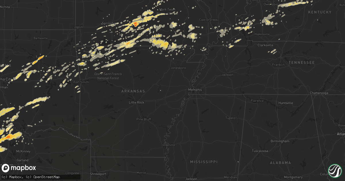
Hail Map in Missouri on April 23, 2011
Get this storm
April 23 map
$229
one time, instant access
Download today. No call, no setup
Keep the $229
Bought the map and want the full workflow? Apply the entire $229 to a subscription within 7 days. None of it is wasted.
Every map, not just this one
This buys you this map. Subscription and you get every map we run, in the markets you choose from a few cities to whole states to nationwide. Plus real-time alerts the moment a storm fires.
Contact data
Name, contact info, occupancy, even credit band for addresses in the footprint. You go from where it hit to who to call.
Become the source they trust
Unlimited branding weather history reports on demand. You already have the documented answer ready for the property owner, and you are the one who showed up with it.
Property data and RoofTrace estimates
Pull up any address you have got, its value and the exact code rules for that jurisdiction, straight from One Click Code. Then RoofTrace estimates the squares, pitch, and roof value, priced the way you price.
Storm reports in Missouri
Missouri
| Date | Description |
|---|---|
| 04/23/20115:45 PM CDT | A local report indicates 1.50 inch wind near LEASBURG |
| 04/23/20115:45 PM CDT | A local report indicates 1.50 inch wind near BOURBON |
| 04/23/20115:45 PM CDT | Spotter located in leesburg missouri |
| 04/23/20115:38 PM CDT | A local report indicates 1.00 inch wind near CUBA |
| 04/23/20114:40 PM CDT | Relayed report. |
| 04/23/20114:40 PM CDT | A local report indicates 1.00 inch wind near DORA |
| 04/23/20114:40 PM CDT | A local report indicates 1.00 inch wind near FORDLAND |
| 04/23/20114:40 PM CDT | A local report indicates 1.00 inch wind near SEYMOUR |
| 04/23/20114:30 PM CDT | A local report indicates 2.50 inch wind near MOUNTAIN GROVE |
| 04/23/20114:28 PM CDT | A local report indicates 1.00 inch wind near 4 NE FORDLAND |
| 04/23/20114:25 PM CDT | A local report indicates 1.50 inch wind near 1 N MOUNTAIN GROVE |
| 04/23/20114:18 PM CDT | A local report indicates 1.00 inch wind near 2 N PLEASANT HOPE |
| 04/23/20114:08 PM CDT | Reported at battlefield and u.s. 65 in springfield. |
| 04/23/20113:55 PM CDT | A local report indicates 1.50 inch wind near 1 S RAYMONDVILLE |
| 04/23/20113:51 PM CDT | A local report indicates 1.00 inch wind near THEODOSIA |
| 04/23/20113:47 PM CDT | Hail covered the ground. |
| 04/23/20113:45 PM CDT | A local report indicates 1.00 inch wind near 1 S REPUBLIC |
| 04/23/20113:28 PM CDT | Volunteer observer. |
| 04/23/20113:10 PM CDT | Ping pong ball sized hail reported north of mansfield. Reports of cars dented by hail. |
| 04/23/20113:08 PM CDT | Reorted quarter sized hail covering the gound. |
| 04/23/20113:00 PM CDT | Delayed report cocorahs. |
| 04/23/20112:56 PM CDT | A local report indicates 1.00 inch wind near 1 E SEYMOUR |
| 04/23/20112:54 PM CDT | A local report indicates 1.00 inch wind near 4 S FORDLAND |
| 04/23/20112:30 PM CDT | Time estimated. Late report. Storage trailer had roof peeled off. 40 foot tree snapped. Shingle damage. |
| 04/23/20112:15 PM CDT | Brief touchdown of ef0 tornado on west side of community. Event along 3 mile road near railroad tracks and just north of west grant street. Large storage building destr |
| 04/23/20112:02 PM CDT | Late report. Couple of sheds blown over. |
| 04/23/20112:01 PM CDT | Late report. Older brick building under demolation had collapsed. |
| 04/23/201112:20 AM CDT | Power lines down and electricity out in the town. |
| 04/23/201112:20 AM CDT | ...late report...ef-1 tornado occurred along u.s. Highway 67. Path length 0.6 miles. Two mobile homes destroyed. |
| 04/22/201111:31 PM CDT | Hail fell on the southside in the town of portageville |
| 04/22/20117:29 PM CDT | A local report indicates 1.00 inch wind near MANSFIELD |
| 04/22/20117:28 PM CDT | A local report indicates 1.25 inch wind near MANSFIELD |
All States Impacted by Hail Map on April 23, 2011
Cities Impacted by Hail Map on April 23, 2011
- Gainesville, TX
- Marietta, OK
- Barlow, KY
- Boley, OK
- Myrtle, MO
- Couch, MO
- Lindsay, TX
- Muenster, TX
- Hulbert, OK
- Tahlequah, OK
- Edgar Springs, MO
- Hartville, MO
- Mountain Grove, MO
- Salem, MO
- Ava, MO
- Eunice, MO
- Raymondville, MO
- Jadwin, MO
- Hartshorn, MO
- Yukon, MO
- Elk Creek, MO
- Macomb, MO
- Drury, MO
- Licking, MO
- Bucyrus, MO
- Seymour, MO
- Fordland, MO
- Houston, MO
- Huggins, MO
- Plato, MO
- Mansfield, MO
- Bunker, MO
- Norwood, MO
- Solo, MO
- Cabool, MO
- Graff, MO
- Squires, MO
- Wasola, MO
- Noble, MO
- Irvington, KY
- Garfield, KY
- Shawnee, OK
- Mcloud, OK
- Floyds Knobs, IN
- Clarksville, IN
- Sellersburg, IN
- Louisville, KY
- Glenview, KY
- Jeffersonville, IN
- Charlestown, IN
- Borden, IN
- New Albany, IN
- Prospect, KY
- Rogersville, MO
- Clermont, KY
- Coxs Creek, KY
- Ashland City, TN
- Charlotte, TN
- Kirksey, KY
- Murray, KY
- Farmington, KY
- Winchester, KY
- Poteau, OK
- Cameron, OK
- Coalgate, OK
- Shepherdsville, KY
- Lebanon Junction, KY
- Muskogee, OK
- Oktaha, OK
- Fort Gibson, OK
- Howe, TX
- Paducah, KY
- Morris, OK
- Boynton, OK
- Belleview, MO
- Duncan, OK
- Marlow, OK
- Davis, OK
- Hennepin, OK
- Chapmansboro, TN
- Springfield, TN
- Pleasant View, TN
- Joelton, TN
- Gentry, AR
- Morgantown, KY
- Duke, MO
- Bradley, OK
- Birch Tree, MO
- Protem, MO
- Peel, AR
- Theodosia, MO
- Lead Hill, AR
- Yellville, AR
- Saint Joe, AR
- Pindall, AR
- Palo Pinto, TX
- Gordon, TX
- Santo, TX
- Ector, TX
- Bonham, TX
- Ledbetter, KY
- Calvert City, KY
- Sidney, TX
- Rising Star, TX
- May, TX
- Blanket, TX
- Gorman, TX
- Dublin, TX
- Gustine, TX
- De Leon, TX
- Stephenville, TX
- Comanche, TX
- Stamford, TX
- Sheppard Afb, TX
- Burkburnett, TX
- Wichita Falls, TX
- Bardwell, KY
- Ravenden Springs, AR
- Gatewood, MO
- Moody, MO
- Pocahontas, AR
- Alton, MO
- Caulfield, MO
- Warm Springs, AR
- West Plains, MO
- Koshkonong, MO
- Peace Valley, MO
- Pottersville, MO
- Mammoth Spring, AR
- Ravenden, AR
- Thayer, MO
- Brandsville, MO
- Foss, OK
- Albany, TX
- Lueders, TX
- Waurika, OK
- Ardmore, OK
- Cuba, MO
- Steelville, MO
- Perrin, TX
- Graford, TX
- Healdton, OK
- Stuart, OK
- Willow Springs, MO
- Dora, MO
- Mountain View, MO
- Bunch, OK
- Bluff Dale, TX
- Maynard, AR
- Doniphan, MO
- Okemah, OK
- Paden, OK
- Castle, OK
- Bristow, OK
- Temple, OK
- Byers, TX
- Cadiz, KY
- Hardinsburg, KY
- Cloverport, KY
- Falls Of Rough, KY
- Harned, KY
- Reynolds Station, KY
- Anson, TX
- Merkel, TX
- Hawley, TX
- Abilene, TX
- Sapulpa, OK
- Tulsa, OK
- Kellyville, OK
- Marquand, MO
- Elmore City, OK
- Van Buren, MO
- Ellington, MO
- Piedmont, MO
- Burneyville, OK
- Wilson, OK
- Overbrook, OK
- Ranger, TX
- Gainesville, MO
- Brixey, MO
- Zanoni, MO
- Sallisaw, OK
- Paoli, IN
- Cook Sta, MO
- Mill Creek, OK
- Thackerville, OK
- Success, MO
- Westville, OK
- Devol, OK
- Pottsboro, TX
- Forestburg, TX
- Whitesboro, TX
- Sherman, TX
- Saint Jo, TX
- Sadler, TX
- Haskell, TX
- Rule, TX
- Elkview, WV
- Augusta, AR
- Randlett, OK
- West Point, KY
- Frederick, OK
- Tipton, OK
- Isabella, MO
- Mcalester, OK
- Early, TX
- Brownwood, TX
- Fulton, KY
- Park Hill, OK
- Cookson, OK
- Lewisport, KY
- Rogers, AR
- Ringling, OK
- Spiro, OK
- Van Alstyne, TX
- Tupelo, OK
- Allen, OK
- Centrahoma, OK
- Kuttawa, KY
- Brookport, IL
- Leon, OK
- Montague, TX
- Nocona, TX
- Carbon, TX
- Prairie Grove, AR
- Lincoln, AR
- Thornfield, MO
- Advance, MO
- Stillwater, OK
- Deer, AR
- Fayetteville, AR
- Siloam Springs, AR
- Springdale, AR
- Lowell, AR
- Cave Springs, AR
- Bentonville, AR
- Kiowa, OK
- Calvin, OK
- Blanco, OK
- Savanna, OK
- Bourbon, MO
- Sunset, TX
- Alvord, TX
- Willard, MO
- Berryville, AR
- Huntsville, AR
- Eastland, TX
- Mingus, TX
- Desdemona, TX
- Strawn, TX
- Vian, OK
- Lawton, OK
- Walters, OK
- Saint James, MO
- Moran, TX
- Paradise, TX
- Krum, TX
- Chico, TX
- Bowie, TX
- Jacksboro, TX
- Bridgeport, TX
- Valley View, TX
- Rhome, TX
- Decatur, TX
- Ponder, TX
- Rosston, TX
- Meridian, OK
- Edmond, OK
- Guthrie, OK
- Coyle, OK
- Henrietta, TX
- Exeter, MO
- Cassville, MO
- Purdy, MO
- Success, AR
- Naylor, MO
- Shell Knob, MO
- Bernie, MO
- Campbell, MO
- Proctor, OK
- Elkins, AR
- Combs, AR
- Wardville, OK
- Vine Grove, KY
- Elizabethtown, KY
- Radcliff, KY
- Custer, KY
- Rineyville, KY
- Nixa, MO
- Ozark, MO
- Ash Grove, MO
- Keota, OK
- Stigler, OK
- Wagoner, OK
- Porter, OK
- Princeton, KY
- Dawson Springs, KY
- Providence, KY
- Ironton, MO
- Arcadia, MO
- Cashion, OK
- Okarche, OK
- Watonga, OK
- Ponca, AR
- Tolar, TX
- Hico, TX
- Lipan, TX
- Mineral Wells, TX
- Millsap, TX
- Arapaho, OK
- Stonewall, OK
- Roff, OK
- Springfield, MO
- Powell, MO
- Washburn, MO
- Lowndes, MO
- Wappapello, MO
- Zalma, MO
- McGee, MO
- Gipsy, MO
- Graham, KY
- Greenville, KY
- White Plains, KY
- Ratliff City, OK
- Wynnewood, OK
- Graham, OK
- Hastings, OK
- Loco, OK
- Sulphur, OK
- Springer, OK
- West Fork, AR
- Canehill, AR
- Summers, AR
- Breckenridge, TX
- Sullivan, MO
- Durant, OK
- Alpena, AR
- Omaha, AR
- Green Forest, AR
- Harrison, AR
- Golconda, IL
- Leedey, OK
- Centertown, KY
- Rush Springs, OK
- Everton, AR
- Marion, KY
- Chandler, OK
- Poolville, TX
- Denison, TX
- Monett, MO
- Adairville, KY
- Geronimo, OK
- Williamsville, MO
- Republic, MO
- Ekron, KY
- Fordsville, KY
- Cecilia, KY
- Guston, KY
- Fort Knox, KY
- Council Hill, OK
- Checotah, OK
- Hindsville, AR
- Cherokee Village, AR
- Hardy, AR
- Perryville, MO
- Braggs, OK
- Electra, TX
- Bokchito, OK
- Corning, AR
- Neelyville, MO
- Nortonville, KY
- Weatherford, OK
- Vanzant, MO
- Flippin, AR
- Gassville, AR
- Cotter, AR
- Mountain Home, AR
- Haskell, OK
- Mortons Gap, KY
- Powderly, KY
- Island, KY
- Drakesboro, KY
- Bremen, KY
- Central City, KY
- Beech Creek, KY
- Earlington, KY
- Beechmont, KY
- Sacramento, KY
- Madisonville, KY
- Anderson, MO
- Depew, OK
- Farmington, MO
- Portageville, MO
- Eddyville, KY
- Owasso, OK
- Catoosa, OK
- Hawesville, KY
- Petrolia, TX
- Water Valley, KY
- Wingo, KY
- Dexter, MO
- Meeker, OK
- Sparks, OK
- Vendor, AR
- Jasper, AR
- Parthenon, AR
- Hasty, AR
- Western Grove, AR
- Noel, MO
- Kevil, KY
- Ryan, OK
- Comanche, OK
- Leasburg, MO
- Lesterville, MO
- Silva, MO
- Clinton, OK
- Pilot Point, TX
- Eufaula, OK
- Summersville, MO
- Oakland, AR
- Pontiac, MO
- Niangua, MO
- Newalla, OK
- Norman, OK
- Knobel, AR
- Paragould, AR
- Golden, MO
- Fredonia, KY
- Crestwood, KY
- Bloomfield, MO
- Essex, MO
- Lenox, MO
- Buffalo, WV
- Charleston, WV
- Poca, WV
- Oark, AR
- Omega, OK
- Hartford, KY
- Dudley, MO
- Garfield, AR
- Aurora, MO
- Marionville, MO
- Billings, MO
- South West City, MO
- Lindsay, OK
- Williford, AR
- Mount Eden, KY
- Bloomfield, KY
- Lawrenceburg, KY
- Beggs, OK
- Okmulgee, OK
- Mayfield, KY
- Martin, TN
- Sedalia, KY
- Dukedom, TN
- Palmersville, TN
- Stilwell, OK
- Muldrow, OK
- Charleston, MO
- Puxico, MO
- Camp, AR
- Eureka Springs, AR
- Avoca, TX
- Crane, MO
- Iowa Park, TX
- Summit, AR
- Stroud, OK
- Prague, OK
- Corydon, IN
- Kingston, AR
- Annapolis, MO
- Eagle Rock, MO
- Butler, OK
- Canute, OK
- Grandin, MO
- Tioga, TX
- Collinsville, TX
- Pettigrew, AR
- Elk City, OK
- La Center, KY
- Wickliffe, KY
- Ellsinore, MO
- Indiahoma, OK
- Grand Rivers, KY
- Gandeeville, WV
- Advent, WV
- Kenna, WV
- Kinta, OK
- Fisk, MO
- Poplar Bluff, MO
- Cheyenne, OK
- Sweetwater, OK
- Eminence, MO
- Fredericktown, MO
- Reeds Spring, MO
- Fremont, MO
- Brookline, MO
- Bennington, OK
- Greenfield, TN
- Marshfield, MO
- Pineville, MO
- Lone Grove, OK
- Grandfield, OK
- Mount Sterling, KY
- Sperry, OK
- Whitesville, KY
- Winslow, AR
- Philpot, KY
- Brandenburg, KY
- Smithland, KY
- Tiline, KY
- Salem, KY
- Greenfield, OK
- Bell City, MO
- Oran, MO
- Crofton, KY
- Highlandville, MO
- Cache, OK
- Ash Flat, AR
- Bardstown, KY
- Boston, KY
- Almo, KY
- South Fulton, TN
- Farmington, AR
- Marmaduke, AR
- Lafe, AR
- Scooba, MS
- Winona, MO
- Sikeston, MO
- Hackett, AR
- Grovespring, MO
- Peach Orchard, AR
- Delaplaine, AR
- Jay, OK
- Sayre, OK
- Winfield, WV
- Nitro, WV
- Hurricane, WV
- Scott Depot, WV
- Red House, WV
- Saint Albans, WV
- Hanna, OK
- Dustin, OK
- Perkins, OK
- Clever, MO
- Taloga, OK
- Whitewright, TX
- Horse Branch, KY
- Beaver Dam, KY
- Pollard, AR
- Custer City, OK
- Liberty, WV
- Leon, WV
- Fraziers Bottom, WV
- Saint Paul, AR
- Henryetta, OK
- Calhoun, KY
- Drumright, OK
- Cushing, OK
- Kingfisher, OK
- Trenton, TX
- Bella Vista, AR
- Rueter, MO
- Galena, MO
- Biggers, AR
- Sparta, MO
- Cherryville, MO
- Davisville, MO
- Pocola, OK
- Georgetown, IN
- Oak Grove, AR
- Ridgedale, MO
- Hollister, MO
- Blue Eye, MO
- Marble Falls, AR
- Foster, OK
- Crescent, OK
- Bradleyville, MO
- Arlington, KY
- Greenville, MO
- Sturdivant, MO
- Mannsville, OK
- Tishomingo, OK
- Madill, OK
- Chadwick, MO
- Kirbyville, MO
- Powersite, MO
- Forsyth, MO
- Hoyleton, IL
- Cunningham, KY
- Gunter, TX
- Lexington, KY
- Belton, KY
- Verona, MO
- Broseley, MO
- Bakersfield, MO
- Cannelton, IN
- Burna, KY
- Witter, AR
- Wesco, MO
- Welling, OK
- Hardenville, MO
- Weleetka, OK
- Gilbertsville, KY
- Benton, KY
- Walnut Ridge, AR
- Tecumseh, MO
- Pomona, MO
- Cedarcreek, MO
- Clay, KY
- Clinton, KY
- Seligman, MO
- Falcon, MO
- Brownwood, MO
- Lane, OK
- Atoka, OK
- Olaton, KY
- Mounds, OK
- Weatherford, TX
- Mill Spring, MO
- Piggott, AR
- Windthorst, TX
- Livermore, KY
- Oklahoma City, OK
- Piedmont, OK
- Centerville, MO
- Compton, AR
- Wetumka, OK
- Oldfield, MO
- Natural Dam, AR
- Chester, AR
- Campbellsville, KY
- Owensboro, KY
- Imboden, AR
- Dover, OK
- Porum, OK
- Whitefield, OK
- Taneyville, MO
- Wheeler, TX
- Shamrock, TX
- Wesley, AR
- Taft, OK
- Salem, AR
- Fitzhugh, OK
- Hampton, KY
- Wardell, MO
- Gravette, AR
- Hiwasse, AR
- Mount Judea, AR
- Cairo, IL
- Ramsey, IN
- New Salisbury, IN
- Bois D Arc, MO
- Cromwell, KY
- Caneyville, KY
- Depauw, IN
- Vulcan, MO
- Lampe, MO
- Kimberling City, MO
- Watts, OK
- Mount Vernon, MO
- Decatur, AR
- Dunmor, KY
- Browder, KY
- Garrison, MO
- Fort Sill, OK
- Geary, OK
- Taylorsville, KY
- Melber, KY
- Briscoe, TX
- Krebs, OK
- Patterson, MO
- Branson, MO
- Brighton, MO
- Pleasant Hope, MO


