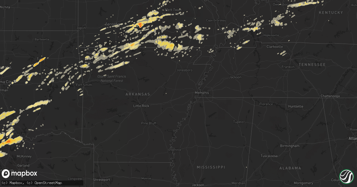
Hail Map in Kentucky on April 23, 2011
Get this storm
April 23 map
$229
one time, instant access
Download today. No call, no setup
Keep the $229
Bought the map and want the full workflow? Apply the entire $229 to a subscription within 7 days. None of it is wasted.
Every map, not just this one
This buys you this map. Subscription and you get every map we run, in the markets you choose from a few cities to whole states to nationwide. Plus real-time alerts the moment a storm fires.
Contact data
Name, contact info, occupancy, even credit band for addresses in the footprint. You go from where it hit to who to call.
Become the source they trust
Unlimited branding weather history reports on demand. You already have the documented answer ready for the property owner, and you are the one who showed up with it.
Property data and RoofTrace estimates
Pull up any address you have got, its value and the exact code rules for that jurisdiction, straight from One Click Code. Then RoofTrace estimates the squares, pitch, and roof value, priced the way you price.
Storm reports in Kentucky
Kentucky
| Date | Description |
|---|---|
| 04/23/20115:35 PM CDT | Quarter sized hail reported |
| 04/23/20115:21 PM CDT | Pea to quarter sized hail reported |
| 04/23/20114:58 PM CDT | Ham relayed two reports of quarter sized hail |
| 04/23/20114:57 PM CDT | Weht relayed spotter report of estimated wind gusts between 60-70 mph |
| 04/23/20114:55 PM CDT | Nickel and quarter size hail reported. |
| 04/23/20114:50 PM CDT | A local report indicates 1.00 inch wind near 3 NW CENTERTOWN |
| 04/23/20114:49 PM CDT | Quarter size hail. |
| 04/23/20114:34 PM CDT | Quarter sized hail covered roadways |
| 04/23/20114:16 PM CDT | Tree down on car at city park. |
| 04/23/20114:07 PM CDT | Trees and power lines down |
| 04/23/20113:38 PM CDT | Golf ball size hail reported at the prison. |
| 04/23/20113:30 PM CDT | Large tree limbs were reported down. |
| 04/23/20113:00 PM CDT | Downed and uprooted trees along with some power poles damaged near intersection of bruce and pecan drive. |
| 04/23/20112:50 PM CDT | Measured gust at barkley regional airport. |
| 04/23/20112:50 PM CDT | Late report. Tree damage reported throughout the area. Underpinning on several mobile homes damaged. |
| 04/23/20112:48 PM CDT | In the town of dover. Three houses have trees downed on them. |
| 04/23/20112:40 PM CDT | Large branches down in town with unknown size hail. Barn downed outside of town. |
| 04/23/20112:40 PM CDT | Barn blown down on augusta chatham rd east. One foot diameter trees blown down in dutch ridge road area. |
| 04/23/20112:30 PM CDT | *** 2 inj *** one steel building destroyed. Entire walls demolished on older 2 story brick business bldgs. Approximately 30 large trees uprooted and around a hundred sm |
| 04/23/20112:29 PM CDT | Ef1 tornado...peak wind 99 mph. Average path width 65 yards...path length was 1.6 miles. Large tree on one home and two mobile homes. Minor roof damage on two homes and |
| 04/23/20112:22 PM CDT | Barn blown over. Time estimated from radar. |
| 04/23/20112:20 PM CDT | Home damaged/trees downed/power lines downed |
| 04/23/20112:20 PM CDT | 2 large cedar trees down. Time estimated from radar. |
| 04/23/20112:20 PM CDT | Numerous trees down in the central part of the county. Time estimated. |
| 04/23/20112:17 PM CDT | Trees across highway 1316. Reports of roofs off of outbuildings. |
| 04/23/20112:15 PM CDT | In visalia...2 homes with roofs blown off. Visalia elementary school building damaged. Trees downed/power lines with trees on them. |
| 04/23/20112:14 PM CDT | A survey confirmed an ef1 tornado with maximum winds of 95 mph. The path length was 1000 feet and the maximum path width was 50 yards. The tornado blew down numerous tr |
| 04/23/20112:10 PM CDT | Preliminary estimate of an ef1 tornado that touched down 1 mile east of dry ridge on greenville road. Damage continued from grant county into pendleton county approxima |
| 04/23/20112:05 PM CDT | Barn roof blown off. Trees and telephone poles downed on warsaw road/ky 467 |
| 04/23/20112:04 PM CDT | Roof damaged on a home on folsom-jonesville road. Trees across the road and telephone poles blown over. |
| 04/23/20111:59 PM CDT | A survey confirmed an ef0 tornado with maximum winds of 75 mph. The path length was 1.2 miles and the maximum path width was 25 yards. The tornado destroyed a garage on |
| 04/22/20117:45 PM CDT | Firefighter reports quarter sized hail between 845 and 900 pm edt. |
All States Impacted by Hail Map on April 23, 2011
Cities Impacted by Hail Map on April 23, 2011
- Gainesville, TX
- Marietta, OK
- Barlow, KY
- Boley, OK
- Myrtle, MO
- Couch, MO
- Lindsay, TX
- Muenster, TX
- Hulbert, OK
- Tahlequah, OK
- Edgar Springs, MO
- Hartville, MO
- Mountain Grove, MO
- Salem, MO
- Ava, MO
- Eunice, MO
- Raymondville, MO
- Jadwin, MO
- Hartshorn, MO
- Yukon, MO
- Elk Creek, MO
- Macomb, MO
- Drury, MO
- Licking, MO
- Bucyrus, MO
- Seymour, MO
- Fordland, MO
- Houston, MO
- Huggins, MO
- Plato, MO
- Mansfield, MO
- Bunker, MO
- Norwood, MO
- Solo, MO
- Cabool, MO
- Graff, MO
- Squires, MO
- Wasola, MO
- Noble, MO
- Irvington, KY
- Garfield, KY
- Shawnee, OK
- Mcloud, OK
- Floyds Knobs, IN
- Clarksville, IN
- Sellersburg, IN
- Louisville, KY
- Glenview, KY
- Jeffersonville, IN
- Charlestown, IN
- Borden, IN
- New Albany, IN
- Prospect, KY
- Rogersville, MO
- Clermont, KY
- Coxs Creek, KY
- Ashland City, TN
- Charlotte, TN
- Kirksey, KY
- Murray, KY
- Farmington, KY
- Winchester, KY
- Poteau, OK
- Cameron, OK
- Coalgate, OK
- Shepherdsville, KY
- Lebanon Junction, KY
- Muskogee, OK
- Oktaha, OK
- Fort Gibson, OK
- Howe, TX
- Paducah, KY
- Morris, OK
- Boynton, OK
- Belleview, MO
- Duncan, OK
- Marlow, OK
- Davis, OK
- Hennepin, OK
- Chapmansboro, TN
- Springfield, TN
- Pleasant View, TN
- Joelton, TN
- Gentry, AR
- Morgantown, KY
- Duke, MO
- Bradley, OK
- Birch Tree, MO
- Protem, MO
- Peel, AR
- Theodosia, MO
- Lead Hill, AR
- Yellville, AR
- Saint Joe, AR
- Pindall, AR
- Palo Pinto, TX
- Gordon, TX
- Santo, TX
- Ector, TX
- Bonham, TX
- Ledbetter, KY
- Calvert City, KY
- Sidney, TX
- Rising Star, TX
- May, TX
- Blanket, TX
- Gorman, TX
- Dublin, TX
- Gustine, TX
- De Leon, TX
- Stephenville, TX
- Comanche, TX
- Stamford, TX
- Sheppard Afb, TX
- Burkburnett, TX
- Wichita Falls, TX
- Bardwell, KY
- Ravenden Springs, AR
- Gatewood, MO
- Moody, MO
- Pocahontas, AR
- Alton, MO
- Caulfield, MO
- Warm Springs, AR
- West Plains, MO
- Koshkonong, MO
- Peace Valley, MO
- Pottersville, MO
- Mammoth Spring, AR
- Ravenden, AR
- Thayer, MO
- Brandsville, MO
- Foss, OK
- Albany, TX
- Lueders, TX
- Waurika, OK
- Ardmore, OK
- Cuba, MO
- Steelville, MO
- Perrin, TX
- Graford, TX
- Healdton, OK
- Stuart, OK
- Willow Springs, MO
- Dora, MO
- Mountain View, MO
- Bunch, OK
- Bluff Dale, TX
- Maynard, AR
- Doniphan, MO
- Okemah, OK
- Paden, OK
- Castle, OK
- Bristow, OK
- Temple, OK
- Byers, TX
- Cadiz, KY
- Hardinsburg, KY
- Cloverport, KY
- Falls Of Rough, KY
- Harned, KY
- Reynolds Station, KY
- Anson, TX
- Merkel, TX
- Hawley, TX
- Abilene, TX
- Sapulpa, OK
- Tulsa, OK
- Kellyville, OK
- Marquand, MO
- Elmore City, OK
- Van Buren, MO
- Ellington, MO
- Piedmont, MO
- Burneyville, OK
- Wilson, OK
- Overbrook, OK
- Ranger, TX
- Gainesville, MO
- Brixey, MO
- Zanoni, MO
- Sallisaw, OK
- Paoli, IN
- Cook Sta, MO
- Mill Creek, OK
- Thackerville, OK
- Success, MO
- Westville, OK
- Devol, OK
- Pottsboro, TX
- Forestburg, TX
- Whitesboro, TX
- Sherman, TX
- Saint Jo, TX
- Sadler, TX
- Haskell, TX
- Rule, TX
- Elkview, WV
- Augusta, AR
- Randlett, OK
- West Point, KY
- Frederick, OK
- Tipton, OK
- Isabella, MO
- Mcalester, OK
- Early, TX
- Brownwood, TX
- Fulton, KY
- Park Hill, OK
- Cookson, OK
- Lewisport, KY
- Rogers, AR
- Ringling, OK
- Spiro, OK
- Van Alstyne, TX
- Tupelo, OK
- Allen, OK
- Centrahoma, OK
- Kuttawa, KY
- Brookport, IL
- Leon, OK
- Montague, TX
- Nocona, TX
- Carbon, TX
- Prairie Grove, AR
- Lincoln, AR
- Thornfield, MO
- Advance, MO
- Stillwater, OK
- Deer, AR
- Fayetteville, AR
- Siloam Springs, AR
- Springdale, AR
- Lowell, AR
- Cave Springs, AR
- Bentonville, AR
- Kiowa, OK
- Calvin, OK
- Blanco, OK
- Savanna, OK
- Bourbon, MO
- Sunset, TX
- Alvord, TX
- Willard, MO
- Berryville, AR
- Huntsville, AR
- Eastland, TX
- Mingus, TX
- Desdemona, TX
- Strawn, TX
- Vian, OK
- Lawton, OK
- Walters, OK
- Saint James, MO
- Moran, TX
- Paradise, TX
- Krum, TX
- Chico, TX
- Bowie, TX
- Jacksboro, TX
- Bridgeport, TX
- Valley View, TX
- Rhome, TX
- Decatur, TX
- Ponder, TX
- Rosston, TX
- Meridian, OK
- Edmond, OK
- Guthrie, OK
- Coyle, OK
- Henrietta, TX
- Exeter, MO
- Cassville, MO
- Purdy, MO
- Success, AR
- Naylor, MO
- Shell Knob, MO
- Bernie, MO
- Campbell, MO
- Proctor, OK
- Elkins, AR
- Combs, AR
- Wardville, OK
- Vine Grove, KY
- Elizabethtown, KY
- Radcliff, KY
- Custer, KY
- Rineyville, KY
- Nixa, MO
- Ozark, MO
- Ash Grove, MO
- Keota, OK
- Stigler, OK
- Wagoner, OK
- Porter, OK
- Princeton, KY
- Dawson Springs, KY
- Providence, KY
- Ironton, MO
- Arcadia, MO
- Cashion, OK
- Okarche, OK
- Watonga, OK
- Ponca, AR
- Tolar, TX
- Hico, TX
- Lipan, TX
- Mineral Wells, TX
- Millsap, TX
- Arapaho, OK
- Stonewall, OK
- Roff, OK
- Springfield, MO
- Powell, MO
- Washburn, MO
- Lowndes, MO
- Wappapello, MO
- Zalma, MO
- McGee, MO
- Gipsy, MO
- Graham, KY
- Greenville, KY
- White Plains, KY
- Ratliff City, OK
- Wynnewood, OK
- Graham, OK
- Hastings, OK
- Loco, OK
- Sulphur, OK
- Springer, OK
- West Fork, AR
- Canehill, AR
- Summers, AR
- Breckenridge, TX
- Sullivan, MO
- Durant, OK
- Alpena, AR
- Omaha, AR
- Green Forest, AR
- Harrison, AR
- Golconda, IL
- Leedey, OK
- Centertown, KY
- Rush Springs, OK
- Everton, AR
- Marion, KY
- Chandler, OK
- Poolville, TX
- Denison, TX
- Monett, MO
- Adairville, KY
- Geronimo, OK
- Williamsville, MO
- Republic, MO
- Ekron, KY
- Fordsville, KY
- Cecilia, KY
- Guston, KY
- Fort Knox, KY
- Council Hill, OK
- Checotah, OK
- Hindsville, AR
- Cherokee Village, AR
- Hardy, AR
- Perryville, MO
- Braggs, OK
- Electra, TX
- Bokchito, OK
- Corning, AR
- Neelyville, MO
- Nortonville, KY
- Weatherford, OK
- Vanzant, MO
- Flippin, AR
- Gassville, AR
- Cotter, AR
- Mountain Home, AR
- Haskell, OK
- Mortons Gap, KY
- Powderly, KY
- Island, KY
- Drakesboro, KY
- Bremen, KY
- Central City, KY
- Beech Creek, KY
- Earlington, KY
- Beechmont, KY
- Sacramento, KY
- Madisonville, KY
- Anderson, MO
- Depew, OK
- Farmington, MO
- Portageville, MO
- Eddyville, KY
- Owasso, OK
- Catoosa, OK
- Hawesville, KY
- Petrolia, TX
- Water Valley, KY
- Wingo, KY
- Dexter, MO
- Meeker, OK
- Sparks, OK
- Vendor, AR
- Jasper, AR
- Parthenon, AR
- Hasty, AR
- Western Grove, AR
- Noel, MO
- Kevil, KY
- Ryan, OK
- Comanche, OK
- Leasburg, MO
- Lesterville, MO
- Silva, MO
- Clinton, OK
- Pilot Point, TX
- Eufaula, OK
- Summersville, MO
- Oakland, AR
- Pontiac, MO
- Niangua, MO
- Newalla, OK
- Norman, OK
- Knobel, AR
- Paragould, AR
- Golden, MO
- Fredonia, KY
- Crestwood, KY
- Bloomfield, MO
- Essex, MO
- Lenox, MO
- Buffalo, WV
- Charleston, WV
- Poca, WV
- Oark, AR
- Omega, OK
- Hartford, KY
- Dudley, MO
- Garfield, AR
- Aurora, MO
- Marionville, MO
- Billings, MO
- South West City, MO
- Lindsay, OK
- Williford, AR
- Mount Eden, KY
- Bloomfield, KY
- Lawrenceburg, KY
- Beggs, OK
- Okmulgee, OK
- Mayfield, KY
- Martin, TN
- Sedalia, KY
- Dukedom, TN
- Palmersville, TN
- Stilwell, OK
- Muldrow, OK
- Charleston, MO
- Puxico, MO
- Camp, AR
- Eureka Springs, AR
- Avoca, TX
- Crane, MO
- Iowa Park, TX
- Summit, AR
- Stroud, OK
- Prague, OK
- Corydon, IN
- Kingston, AR
- Annapolis, MO
- Eagle Rock, MO
- Butler, OK
- Canute, OK
- Grandin, MO
- Tioga, TX
- Collinsville, TX
- Pettigrew, AR
- Elk City, OK
- La Center, KY
- Wickliffe, KY
- Ellsinore, MO
- Indiahoma, OK
- Grand Rivers, KY
- Gandeeville, WV
- Advent, WV
- Kenna, WV
- Kinta, OK
- Fisk, MO
- Poplar Bluff, MO
- Cheyenne, OK
- Sweetwater, OK
- Eminence, MO
- Fredericktown, MO
- Reeds Spring, MO
- Fremont, MO
- Brookline, MO
- Bennington, OK
- Greenfield, TN
- Marshfield, MO
- Pineville, MO
- Lone Grove, OK
- Grandfield, OK
- Mount Sterling, KY
- Sperry, OK
- Whitesville, KY
- Winslow, AR
- Philpot, KY
- Brandenburg, KY
- Smithland, KY
- Tiline, KY
- Salem, KY
- Greenfield, OK
- Bell City, MO
- Oran, MO
- Crofton, KY
- Highlandville, MO
- Cache, OK
- Ash Flat, AR
- Bardstown, KY
- Boston, KY
- Almo, KY
- South Fulton, TN
- Farmington, AR
- Marmaduke, AR
- Lafe, AR
- Scooba, MS
- Winona, MO
- Sikeston, MO
- Hackett, AR
- Grovespring, MO
- Peach Orchard, AR
- Delaplaine, AR
- Jay, OK
- Sayre, OK
- Winfield, WV
- Nitro, WV
- Hurricane, WV
- Scott Depot, WV
- Red House, WV
- Saint Albans, WV
- Hanna, OK
- Dustin, OK
- Perkins, OK
- Clever, MO
- Taloga, OK
- Whitewright, TX
- Horse Branch, KY
- Beaver Dam, KY
- Pollard, AR
- Custer City, OK
- Liberty, WV
- Leon, WV
- Fraziers Bottom, WV
- Saint Paul, AR
- Henryetta, OK
- Calhoun, KY
- Drumright, OK
- Cushing, OK
- Kingfisher, OK
- Trenton, TX
- Bella Vista, AR
- Rueter, MO
- Galena, MO
- Biggers, AR
- Sparta, MO
- Cherryville, MO
- Davisville, MO
- Pocola, OK
- Georgetown, IN
- Oak Grove, AR
- Ridgedale, MO
- Hollister, MO
- Blue Eye, MO
- Marble Falls, AR
- Foster, OK
- Crescent, OK
- Bradleyville, MO
- Arlington, KY
- Greenville, MO
- Sturdivant, MO
- Mannsville, OK
- Tishomingo, OK
- Madill, OK
- Chadwick, MO
- Kirbyville, MO
- Powersite, MO
- Forsyth, MO
- Hoyleton, IL
- Cunningham, KY
- Gunter, TX
- Lexington, KY
- Belton, KY
- Verona, MO
- Broseley, MO
- Bakersfield, MO
- Cannelton, IN
- Burna, KY
- Witter, AR
- Wesco, MO
- Welling, OK
- Hardenville, MO
- Weleetka, OK
- Gilbertsville, KY
- Benton, KY
- Walnut Ridge, AR
- Tecumseh, MO
- Pomona, MO
- Cedarcreek, MO
- Clay, KY
- Clinton, KY
- Seligman, MO
- Falcon, MO
- Brownwood, MO
- Lane, OK
- Atoka, OK
- Olaton, KY
- Mounds, OK
- Weatherford, TX
- Mill Spring, MO
- Piggott, AR
- Windthorst, TX
- Livermore, KY
- Oklahoma City, OK
- Piedmont, OK
- Centerville, MO
- Compton, AR
- Wetumka, OK
- Oldfield, MO
- Natural Dam, AR
- Chester, AR
- Campbellsville, KY
- Owensboro, KY
- Imboden, AR
- Dover, OK
- Porum, OK
- Whitefield, OK
- Taneyville, MO
- Wheeler, TX
- Shamrock, TX
- Wesley, AR
- Taft, OK
- Salem, AR
- Fitzhugh, OK
- Hampton, KY
- Wardell, MO
- Gravette, AR
- Hiwasse, AR
- Mount Judea, AR
- Cairo, IL
- Ramsey, IN
- New Salisbury, IN
- Bois D Arc, MO
- Cromwell, KY
- Caneyville, KY
- Depauw, IN
- Vulcan, MO
- Lampe, MO
- Kimberling City, MO
- Watts, OK
- Mount Vernon, MO
- Decatur, AR
- Dunmor, KY
- Browder, KY
- Garrison, MO
- Fort Sill, OK
- Geary, OK
- Taylorsville, KY
- Melber, KY
- Briscoe, TX
- Krebs, OK
- Patterson, MO
- Branson, MO
- Brighton, MO
- Pleasant Hope, MO


