Hail Map in Illinois on April 23, 2011
Get this storm
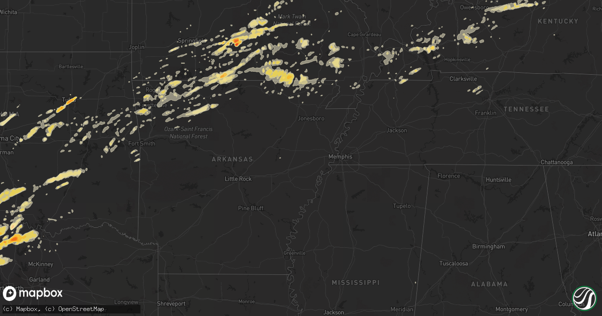
April 23 map
$229
one time, instant access
Download today. No call, no setup
Keep the $229
Bought the map and want the full workflow? Apply the entire $229 to a subscription within 7 days. None of it is wasted.
Every map, not just this one
This buys you this map. Subscription and you get every map we run, in the markets you choose from a few cities to whole states to nationwide. Plus real-time alerts the moment a storm fires.
Contact data
Name, contact info, occupancy, even credit band for addresses in the footprint. You go from where it hit to who to call.
Become the source they trust
Unlimited branding weather history reports on demand. You already have the documented answer ready for the property owner, and you are the one who showed up with it.
Property data and RoofTrace estimates
Pull up any address you have got, its value and the exact code rules for that jurisdiction, straight from One Click Code. Then RoofTrace estimates the squares, pitch, and roof value, priced the way you price.
Storm reports in Illinois
Illinois
| Date | Description |
|---|---|
| 04/23/20113:05 PM CDT | Downed and uprooted trees reported along north street. Downed power poles. One tree is laying across a house. |
| 04/23/20112:57 PM CDT | Widespread trees and power pole damage on the north side of town near the honeywell plant. |
| 04/23/20112:56 PM CDT | Widespread power outages in town. |
| 04/23/20112:47 PM CDT | Ef1 tornado/downburst...peak wind 110 mph. Average path width 225 yds...path length 6.5 miles. Several wooden utility poles snapped/broken along path. Roof off trailer |
| 04/23/20112:15 PM CDT | Ef2 tornado...peak wind 120 mph. Path width 120 yds and path length 2.9 miles. One mobile home destroyed...with minor/moderate roof damage to two homes in the klondike |
All States Impacted by Hail Map on April 23, 2011
Cities Impacted by Hail Map on April 23, 2011
- Gainesville, TX
- Marietta, OK
- Barlow, KY
- Boley, OK
- Myrtle, MO
- Couch, MO
- Lindsay, TX
- Muenster, TX
- Hulbert, OK
- Tahlequah, OK
- Edgar Springs, MO
- Hartville, MO
- Mountain Grove, MO
- Salem, MO
- Ava, MO
- Eunice, MO
- Raymondville, MO
- Jadwin, MO
- Hartshorn, MO
- Yukon, MO
- Elk Creek, MO
- Macomb, MO
- Drury, MO
- Licking, MO
- Bucyrus, MO
- Seymour, MO
- Fordland, MO
- Houston, MO
- Huggins, MO
- Plato, MO
- Mansfield, MO
- Bunker, MO
- Norwood, MO
- Solo, MO
- Cabool, MO
- Graff, MO
- Squires, MO
- Wasola, MO
- Noble, MO
- Irvington, KY
- Garfield, KY
- Shawnee, OK
- Mcloud, OK
- Floyds Knobs, IN
- Clarksville, IN
- Sellersburg, IN
- Louisville, KY
- Glenview, KY
- Jeffersonville, IN
- Charlestown, IN
- Borden, IN
- New Albany, IN
- Prospect, KY
- Rogersville, MO
- Clermont, KY
- Coxs Creek, KY
- Ashland City, TN
- Charlotte, TN
- Kirksey, KY
- Murray, KY
- Farmington, KY
- Winchester, KY
- Poteau, OK
- Cameron, OK
- Coalgate, OK
- Shepherdsville, KY
- Lebanon Junction, KY
- Muskogee, OK
- Oktaha, OK
- Fort Gibson, OK
- Howe, TX
- Paducah, KY
- Morris, OK
- Boynton, OK
- Belleview, MO
- Duncan, OK
- Marlow, OK
- Davis, OK
- Hennepin, OK
- Chapmansboro, TN
- Springfield, TN
- Pleasant View, TN
- Joelton, TN
- Gentry, AR
- Morgantown, KY
- Duke, MO
- Bradley, OK
- Birch Tree, MO
- Protem, MO
- Peel, AR
- Theodosia, MO
- Lead Hill, AR
- Yellville, AR
- Saint Joe, AR
- Pindall, AR
- Palo Pinto, TX
- Gordon, TX
- Santo, TX
- Ector, TX
- Bonham, TX
- Ledbetter, KY
- Calvert City, KY
- Sidney, TX
- Rising Star, TX
- May, TX
- Blanket, TX
- Gorman, TX
- Dublin, TX
- Gustine, TX
- De Leon, TX
- Stephenville, TX
- Comanche, TX
- Stamford, TX
- Sheppard Afb, TX
- Burkburnett, TX
- Wichita Falls, TX
- Bardwell, KY
- Ravenden Springs, AR
- Gatewood, MO
- Moody, MO
- Pocahontas, AR
- Alton, MO
- Caulfield, MO
- Warm Springs, AR
- West Plains, MO
- Koshkonong, MO
- Peace Valley, MO
- Pottersville, MO
- Mammoth Spring, AR
- Ravenden, AR
- Thayer, MO
- Brandsville, MO
- Foss, OK
- Albany, TX
- Lueders, TX
- Waurika, OK
- Ardmore, OK
- Cuba, MO
- Steelville, MO
- Perrin, TX
- Graford, TX
- Healdton, OK
- Stuart, OK
- Willow Springs, MO
- Dora, MO
- Mountain View, MO
- Bunch, OK
- Bluff Dale, TX
- Maynard, AR
- Doniphan, MO
- Okemah, OK
- Paden, OK
- Castle, OK
- Bristow, OK
- Temple, OK
- Byers, TX
- Cadiz, KY
- Hardinsburg, KY
- Cloverport, KY
- Falls Of Rough, KY
- Harned, KY
- Reynolds Station, KY
- Anson, TX
- Merkel, TX
- Hawley, TX
- Abilene, TX
- Sapulpa, OK
- Tulsa, OK
- Kellyville, OK
- Marquand, MO
- Elmore City, OK
- Van Buren, MO
- Ellington, MO
- Piedmont, MO
- Burneyville, OK
- Wilson, OK
- Overbrook, OK
- Ranger, TX
- Gainesville, MO
- Brixey, MO
- Zanoni, MO
- Sallisaw, OK
- Paoli, IN
- Cook Sta, MO
- Mill Creek, OK
- Thackerville, OK
- Success, MO
- Westville, OK
- Devol, OK
- Pottsboro, TX
- Forestburg, TX
- Whitesboro, TX
- Sherman, TX
- Saint Jo, TX
- Sadler, TX
- Haskell, TX
- Rule, TX
- Elkview, WV
- Augusta, AR
- Randlett, OK
- West Point, KY
- Frederick, OK
- Tipton, OK
- Isabella, MO
- Mcalester, OK
- Early, TX
- Brownwood, TX
- Fulton, KY
- Park Hill, OK
- Cookson, OK
- Lewisport, KY
- Rogers, AR
- Ringling, OK
- Spiro, OK
- Van Alstyne, TX
- Tupelo, OK
- Allen, OK
- Centrahoma, OK
- Kuttawa, KY
- Brookport, IL
- Leon, OK
- Montague, TX
- Nocona, TX
- Carbon, TX
- Prairie Grove, AR
- Lincoln, AR
- Thornfield, MO
- Advance, MO
- Stillwater, OK
- Deer, AR
- Fayetteville, AR
- Siloam Springs, AR
- Springdale, AR
- Lowell, AR
- Cave Springs, AR
- Bentonville, AR
- Kiowa, OK
- Calvin, OK
- Blanco, OK
- Savanna, OK
- Bourbon, MO
- Sunset, TX
- Alvord, TX
- Willard, MO
- Berryville, AR
- Huntsville, AR
- Eastland, TX
- Mingus, TX
- Desdemona, TX
- Strawn, TX
- Vian, OK
- Lawton, OK
- Walters, OK
- Saint James, MO
- Moran, TX
- Paradise, TX
- Krum, TX
- Chico, TX
- Bowie, TX
- Jacksboro, TX
- Bridgeport, TX
- Valley View, TX
- Rhome, TX
- Decatur, TX
- Ponder, TX
- Rosston, TX
- Meridian, OK
- Edmond, OK
- Guthrie, OK
- Coyle, OK
- Henrietta, TX
- Exeter, MO
- Cassville, MO
- Purdy, MO
- Success, AR
- Naylor, MO
- Shell Knob, MO
- Bernie, MO
- Campbell, MO
- Proctor, OK
- Elkins, AR
- Combs, AR
- Wardville, OK
- Vine Grove, KY
- Elizabethtown, KY
- Radcliff, KY
- Custer, KY
- Rineyville, KY
- Nixa, MO
- Ozark, MO
- Ash Grove, MO
- Keota, OK
- Stigler, OK
- Wagoner, OK
- Porter, OK
- Princeton, KY
- Dawson Springs, KY
- Providence, KY
- Ironton, MO
- Arcadia, MO
- Cashion, OK
- Okarche, OK
- Watonga, OK
- Ponca, AR
- Tolar, TX
- Hico, TX
- Lipan, TX
- Mineral Wells, TX
- Millsap, TX
- Arapaho, OK
- Stonewall, OK
- Roff, OK
- Springfield, MO
- Powell, MO
- Washburn, MO
- Lowndes, MO
- Wappapello, MO
- Zalma, MO
- McGee, MO
- Gipsy, MO
- Graham, KY
- Greenville, KY
- White Plains, KY
- Ratliff City, OK
- Wynnewood, OK
- Graham, OK
- Hastings, OK
- Loco, OK
- Sulphur, OK
- Springer, OK
- West Fork, AR
- Canehill, AR
- Summers, AR
- Breckenridge, TX
- Sullivan, MO
- Durant, OK
- Alpena, AR
- Omaha, AR
- Green Forest, AR
- Harrison, AR
- Golconda, IL
- Leedey, OK
- Centertown, KY
- Rush Springs, OK
- Everton, AR
- Marion, KY
- Chandler, OK
- Poolville, TX
- Denison, TX
- Monett, MO
- Adairville, KY
- Geronimo, OK
- Williamsville, MO
- Republic, MO
- Ekron, KY
- Fordsville, KY
- Cecilia, KY
- Guston, KY
- Fort Knox, KY
- Council Hill, OK
- Checotah, OK
- Hindsville, AR
- Cherokee Village, AR
- Hardy, AR
- Perryville, MO
- Braggs, OK
- Electra, TX
- Bokchito, OK
- Corning, AR
- Neelyville, MO
- Nortonville, KY
- Weatherford, OK
- Vanzant, MO
- Flippin, AR
- Gassville, AR
- Cotter, AR
- Mountain Home, AR
- Haskell, OK
- Mortons Gap, KY
- Powderly, KY
- Island, KY
- Drakesboro, KY
- Bremen, KY
- Central City, KY
- Beech Creek, KY
- Earlington, KY
- Beechmont, KY
- Sacramento, KY
- Madisonville, KY
- Anderson, MO
- Depew, OK
- Farmington, MO
- Portageville, MO
- Eddyville, KY
- Owasso, OK
- Catoosa, OK
- Hawesville, KY
- Petrolia, TX
- Water Valley, KY
- Wingo, KY
- Dexter, MO
- Meeker, OK
- Sparks, OK
- Vendor, AR
- Jasper, AR
- Parthenon, AR
- Hasty, AR
- Western Grove, AR
- Noel, MO
- Kevil, KY
- Ryan, OK
- Comanche, OK
- Leasburg, MO
- Lesterville, MO
- Silva, MO
- Clinton, OK
- Pilot Point, TX
- Eufaula, OK
- Summersville, MO
- Oakland, AR
- Pontiac, MO
- Niangua, MO
- Newalla, OK
- Norman, OK
- Knobel, AR
- Paragould, AR
- Golden, MO
- Fredonia, KY
- Crestwood, KY
- Bloomfield, MO
- Essex, MO
- Lenox, MO
- Buffalo, WV
- Charleston, WV
- Poca, WV
- Oark, AR
- Omega, OK
- Hartford, KY
- Dudley, MO
- Garfield, AR
- Aurora, MO
- Marionville, MO
- Billings, MO
- South West City, MO
- Lindsay, OK
- Williford, AR
- Mount Eden, KY
- Bloomfield, KY
- Lawrenceburg, KY
- Beggs, OK
- Okmulgee, OK
- Mayfield, KY
- Martin, TN
- Sedalia, KY
- Dukedom, TN
- Palmersville, TN
- Stilwell, OK
- Muldrow, OK
- Charleston, MO
- Puxico, MO
- Camp, AR
- Eureka Springs, AR
- Avoca, TX
- Crane, MO
- Iowa Park, TX
- Summit, AR
- Stroud, OK
- Prague, OK
- Corydon, IN
- Kingston, AR
- Annapolis, MO
- Eagle Rock, MO
- Butler, OK
- Canute, OK
- Grandin, MO
- Tioga, TX
- Collinsville, TX
- Pettigrew, AR
- Elk City, OK
- La Center, KY
- Wickliffe, KY
- Ellsinore, MO
- Indiahoma, OK
- Grand Rivers, KY
- Gandeeville, WV
- Advent, WV
- Kenna, WV
- Kinta, OK
- Fisk, MO
- Poplar Bluff, MO
- Cheyenne, OK
- Sweetwater, OK
- Eminence, MO
- Fredericktown, MO
- Reeds Spring, MO
- Fremont, MO
- Brookline, MO
- Bennington, OK
- Greenfield, TN
- Marshfield, MO
- Pineville, MO
- Lone Grove, OK
- Grandfield, OK
- Mount Sterling, KY
- Sperry, OK
- Whitesville, KY
- Winslow, AR
- Philpot, KY
- Brandenburg, KY
- Smithland, KY
- Tiline, KY
- Salem, KY
- Greenfield, OK
- Bell City, MO
- Oran, MO
- Crofton, KY
- Highlandville, MO
- Cache, OK
- Ash Flat, AR
- Bardstown, KY
- Boston, KY
- Almo, KY
- South Fulton, TN
- Farmington, AR
- Marmaduke, AR
- Lafe, AR
- Scooba, MS
- Winona, MO
- Sikeston, MO
- Hackett, AR
- Grovespring, MO
- Peach Orchard, AR
- Delaplaine, AR
- Jay, OK
- Sayre, OK
- Winfield, WV
- Nitro, WV
- Hurricane, WV
- Scott Depot, WV
- Red House, WV
- Saint Albans, WV
- Hanna, OK
- Dustin, OK
- Perkins, OK
- Clever, MO
- Taloga, OK
- Whitewright, TX
- Horse Branch, KY
- Beaver Dam, KY
- Pollard, AR
- Custer City, OK
- Liberty, WV
- Leon, WV
- Fraziers Bottom, WV
- Saint Paul, AR
- Henryetta, OK
- Calhoun, KY
- Drumright, OK
- Cushing, OK
- Kingfisher, OK
- Trenton, TX
- Bella Vista, AR
- Rueter, MO
- Galena, MO
- Biggers, AR
- Sparta, MO
- Cherryville, MO
- Davisville, MO
- Pocola, OK
- Georgetown, IN
- Oak Grove, AR
- Ridgedale, MO
- Hollister, MO
- Blue Eye, MO
- Marble Falls, AR
- Foster, OK
- Crescent, OK
- Bradleyville, MO
- Arlington, KY
- Greenville, MO
- Sturdivant, MO
- Mannsville, OK
- Tishomingo, OK
- Madill, OK
- Chadwick, MO
- Kirbyville, MO
- Powersite, MO
- Forsyth, MO
- Hoyleton, IL
- Cunningham, KY
- Gunter, TX
- Lexington, KY
- Belton, KY
- Verona, MO
- Broseley, MO
- Bakersfield, MO
- Cannelton, IN
- Burna, KY
- Witter, AR
- Wesco, MO
- Welling, OK
- Hardenville, MO
- Weleetka, OK
- Gilbertsville, KY
- Benton, KY
- Walnut Ridge, AR
- Tecumseh, MO
- Pomona, MO
- Cedarcreek, MO
- Clay, KY
- Clinton, KY
- Seligman, MO
- Falcon, MO
- Brownwood, MO
- Lane, OK
- Atoka, OK
- Olaton, KY
- Mounds, OK
- Weatherford, TX
- Mill Spring, MO
- Piggott, AR
- Windthorst, TX
- Livermore, KY
- Oklahoma City, OK
- Piedmont, OK
- Centerville, MO
- Compton, AR
- Wetumka, OK
- Oldfield, MO
- Natural Dam, AR
- Chester, AR
- Campbellsville, KY
- Owensboro, KY
- Imboden, AR
- Dover, OK
- Porum, OK
- Whitefield, OK
- Taneyville, MO
- Wheeler, TX
- Shamrock, TX
- Wesley, AR
- Taft, OK
- Salem, AR
- Fitzhugh, OK
- Hampton, KY
- Wardell, MO
- Gravette, AR
- Hiwasse, AR
- Mount Judea, AR
- Cairo, IL
- Ramsey, IN
- New Salisbury, IN
- Bois D Arc, MO
- Cromwell, KY
- Caneyville, KY
- Depauw, IN
- Vulcan, MO
- Lampe, MO
- Kimberling City, MO
- Watts, OK
- Mount Vernon, MO
- Decatur, AR
- Dunmor, KY
- Browder, KY
- Garrison, MO
- Fort Sill, OK
- Geary, OK
- Taylorsville, KY
- Melber, KY
- Briscoe, TX
- Krebs, OK
- Patterson, MO
- Branson, MO
- Brighton, MO
- Pleasant Hope, MO


