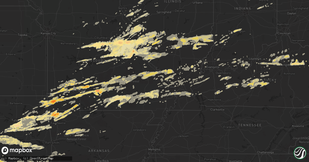
Hail Map in Oklahoma on April 22, 2011
Get this storm
April 22 map
$229
one time, instant access
Download today. No call, no setup
Keep the $229
Bought the map and want the full workflow? Apply the entire $229 to a subscription within 7 days. None of it is wasted.
Every map, not just this one
This buys you this map. Subscription and you get every map we run, in the markets you choose from a few cities to whole states to nationwide. Plus real-time alerts the moment a storm fires.
Contact data
Name, contact info, occupancy, even credit band for addresses in the footprint. You go from where it hit to who to call.
Become the source they trust
Unlimited branding weather history reports on demand. You already have the documented answer ready for the property owner, and you are the one who showed up with it.
Property data and RoofTrace estimates
Pull up any address you have got, its value and the exact code rules for that jurisdiction, straight from One Click Code. Then RoofTrace estimates the squares, pitch, and roof value, priced the way you price.
Storm reports in Oklahoma
Oklahoma
| Date | Description |
|---|---|
| 04/22/20116:50 PM CDT | Golf ball to hen egg sized hail. |
| 04/22/20116:46 PM CDT | A local report indicates 1.00 inch wind near 4 WSW BYARS |
| 04/22/20116:42 PM CDT | A local report indicates 1.75 inch wind near 3 E PINK |
| 04/22/20116:40 PM CDT | Delayed report from pottawatomie nation |
| 04/22/20116:40 PM CDT | Amateur radio report of baseball sized hail 2 miles south of state highway 9 and 2 miles east of highway 102. |
| 04/22/20116:38 PM CDT | A local report indicates 1.25 inch wind near BETHEL ACRES |
| 04/22/20116:30 PM CDT | A local report indicates 1.25 inch wind near COLCORD |
| 04/22/20116:30 PM CDT | A local report indicates 2.75 inch wind near 1 W LINDSAY |
| 04/22/20116:25 PM CDT | A local report indicates 2.75 inch wind near 1 W LINDSAY |
| 04/22/20116:21 PM CDT | A local report indicates 1.50 inch wind near 3 W PAOLI |
| 04/22/20116:18 PM CDT | Golfball hail on hwy 74. |
| 04/22/20116:16 PM CDT | A brief tornado was reported by area fire departments in the flint creek area. No damage was reported. This is preliminary report. |
| 04/22/20116:15 PM CDT | A local report indicates 1.50 inch wind near 4 N KANSAS |
| 04/22/20116:15 PM CDT | A local report indicates 1.25 inch wind near 4 W TECUMSEH |
| 04/22/20116:14 PM CDT | Storm chaser reported a tornado...later reports indicated some tree damage in the area. This is a preliminary report. |
| 04/22/20116:10 PM CDT | Numerous large tree limbs down |
| 04/22/20116:06 PM CDT | A local report indicates 1.00 inch wind near 3 S MAYSVILLE |
| 04/22/20115:55 PM CDT | A local report indicates 1.00 inch wind near 3 N MASON |
| 04/22/20115:49 PM CDT | A local report indicates 1.75 inch wind near 3 S MOUNDS |
| 04/22/20115:40 PM CDT | A local report indicates 1.00 inch wind near 3 W WELTY |
| 04/22/20115:25 PM CDT | E 115th st s and 193rd e ave |
| 04/22/20115:24 PM CDT | A local report indicates 1.00 inch wind near COWETA |
| 04/22/20115:23 PM CDT | A local report indicates 1.00 inch wind near ONETA |
| 04/22/20115:22 PM CDT | A local report indicates 1.75 inch wind near 3 W SALINA |
| 04/22/20115:13 PM CDT | A local report indicates 1.75 inch wind near BIXBY |
| 04/22/20115:10 PM CDT | A local report indicates 2.50 inch wind near BIXBY |
| 04/22/20115:10 PM CDT | 121st and peoria |
| 04/22/20115:09 PM CDT | Creek turnpike and harvard |
| 04/22/20115:06 PM CDT | A local report indicates 1.50 inch wind near 3 S BROKEN ARROW |
| 04/22/20115:06 PM CDT | A local report indicates 1.75 inch wind near BIXBY |
| 04/22/20115:05 PM CDT | 101st and 145th |
| 04/22/20115:00 PM CDT | 121st and peoria |
| 04/22/20115:00 PM CDT | 111th and mingo |
| 04/22/20114:50 PM CDT | A local report indicates 1.00 inch wind near PRYOR |
| 04/22/20114:50 PM CDT | A local report indicates 1.75 inch wind near BIXBY |
| 04/22/20114:47 PM CDT | A local report indicates 1.75 inch wind near GLENPOOL |
| 04/22/20114:47 PM CDT | A local report indicates 1.00 inch wind near 3 SW BRISTOW |
| 04/22/20114:45 PM CDT | A local report indicates 1.75 inch wind near 8 S WYANDOTTE |
| 04/22/20114:25 PM CDT | 6 to 8 inch diameter tree branches down |
| 04/22/20114:25 PM CDT | Thunderstorm wind gusts to 60 mph also reported |
| 04/22/20113:55 PM CDT | A local report indicates 1.25 inch wind near 3 WSW CATOOSA |
| 04/22/20115:15 AM CDT | Very gusty winds. No estimate. |
| 04/22/201112:40 AM CDT | Quarter to golf ball sized hail reported at 8-mile road in central high. |
| 04/22/201112:23 AM CDT | Storm spotter reports hen egg sized hail near byars. |
| 04/21/201111:39 PM CDT | A local report indicates 70 MPH wind near MCALESTER |
| 04/21/201111:30 PM CDT | One inch hail reported near paoli. |
| 04/21/201111:30 PM CDT | 2 inch hail reported in geronimo. |
| 04/21/201111:15 PM CDT | Half dollar sized hail and estimated 60 mph winds in vanoss. |
| 04/21/201111:01 PM CDT | Report of quarter to half dollar sized hail near walters. |
| 04/21/201110:40 PM CDT | Quarter sized hail reported at waurkia lake. |
| 04/21/201110:15 PM CDT | Delayed report of quarter sized hail in wynnewood. |
| 04/21/201110:13 PM CDT | A local report indicates 1.00 inch wind near 2 W CORUM |
| 04/21/20119:36 PM CDT | Multiple reports of quarter sized hail. |
| 04/21/20119:36 PM CDT | A local report indicates 1.75 inch wind near CORUM |
| 04/21/20119:30 PM CDT | Measured oklahoma mesonet wind gust of 58.6 mph from 300 degrees. |
| 04/21/20119:30 PM CDT | A local report indicates 2.75 inch wind near 5 W WALTERS |
| 04/21/20119:26 PM CDT | A local report indicates 1.75 inch wind near 4 W WALTERS |
| 04/21/20119:24 PM CDT | Oklahoma mesonet measured wind gust of 70.9 mph from 301 degrees. |
| 04/21/20119:23 PM CDT | Wind gust to 60 mph and dime sized hail |
| 04/21/20119:22 PM CDT | Quarter to ping pong ball sized hail reported. |
| 04/21/20119:20 PM CDT | Delayed report via duncan pd of golf ball sized hail on western city limit of duncan. |
| 04/21/20119:20 PM CDT | A local report indicates 1.75 inch wind near 8 N SULPHUR |
| 04/21/20119:13 PM CDT | Delayed report via amateur radio. |
| 04/21/20119:09 PM CDT | A local report indicates 1.75 inch wind near 3 S LINDSAY |
| 04/21/20119:09 PM CDT | A local report indicates 1.75 inch wind near 4 NE BRAY |
| 04/21/20119:07 PM CDT | A local report indicates 1.75 inch wind near 1 N COOKIETOWN |
| 04/21/20119:05 PM CDT | A local report indicates 1.00 inch wind near 3 NW WALTERS |
| 04/21/20118:45 PM CDT | Delayed report of quarter sized hail in ryan relayed by ryan fire department. |
| 04/21/20118:28 PM CDT | Reports of downed telephone pole and overturned tractor trailer near stratford. |
| 04/21/20118:26 PM CDT | A local report indicates 1.00 inch wind near WESTVILLE |
| 04/21/20118:25 PM CDT | A local report indicates 1.00 inch wind near WESTVILLE |
| 04/21/20118:23 PM CDT | A local report indicates 2.50 inch wind near 4 NE BRAY |
| 04/21/20118:18 PM CDT | Several tornado touchdowns were reported near onapa. Some tree and power line damage was reported in the area. This is a preliminary report. |
| 04/21/20118:15 PM CDT | A local report indicates 1.50 inch wind near 2 W CHECOTAH |
| 04/21/20118:11 PM CDT | Report relayed through media. |
| 04/21/20118:04 PM CDT | Tornado at us hwy 177 and state hwy 59 |
| 04/21/20117:55 PM CDT | A local report indicates 1.75 inch wind near 2 S LINDSAY |
| 04/21/20117:45 PM CDT | Mostly pea to nickel sized hail with a few stones to the size of quarters. |
| 04/21/20117:39 PM CDT | Delayed public report...hail for 15 minutes with golfball to baseball sized hail. |
| 04/21/20117:30 PM CDT | A local report indicates 2.75 inch wind near 1 W LINDSAY |
| 04/21/20117:20 PM CDT | Tornado reported by a storm chaser. No damage reports have been received from this area. This is a preliminary report. |
| 04/21/20117:17 PM CDT | A brief tornado was reported near moodys. No damage reports have been received from this area. This is a preliminary report. |
| 04/21/20117:15 PM CDT | Delayed public report of quarter and golf ball sized hail in and around hastings. |
| 04/21/20117:04 PM CDT | A local report indicates 1.00 inch wind near TECUMSEH |
All States Impacted by Hail Map on April 22, 2011
Cities Impacted by Hail Map on April 22, 2011
- Ozone, AR
- Hagarville, AR
- Saint Paul, AR
- Ozark, AR
- Pettigrew, AR
- Combs, AR
- Oark, AR
- Deer, AR
- Mount Judea, AR
- Thornfield, MO
- Bridgeport, IL
- Lawrenceville, IL
- Flat Rock, IL
- Oblong, IL
- Robinson, IL
- Sumner, IL
- Claremont, IL
- Sandoval, IL
- Odin, IL
- Bristow, OK
- Linn, MO
- Morrison, MO
- Chamois, MO
- South Greenfield, MO
- Versailles, IL
- Springfield, KY
- Elkland, MO
- Buffalo, MO
- Fair Grove, MO
- Lampe, MO
- Muse, OK
- Noble, OK
- Wanette, OK
- Macomb, OK
- Lexington, OK
- Tecumseh, OK
- Shawnee, OK
- Norman, OK
- Mcloud, OK
- Maud, OK
- Newalla, OK
- Purcell, OK
- Wayne, OK
- Vinita, OK
- Shipman, IL
- Strafford, MO
- Marshfield, MO
- Barry, IL
- Baylis, IL
- Redbird, OK
- Coweta, OK
- Porter, OK
- Mounds, OK
- Bixby, OK
- Tulsa, OK
- Jenks, OK
- Broken Arrow, OK
- Glenpool, OK
- Sapulpa, OK
- Wright City, MO
- Truesdale, MO
- Warrenton, MO
- Marionville, MO
- Mountain Grove, MO
- Mansfield, MO
- Norwood, MO
- Drury, MO
- Macomb, MO
- Annada, MO
- Elsberry, MO
- Inola, OK
- Jamestown, MO
- California, MO
- Elnora, IN
- Plainville, IN
- Washington, IN
- Alton, MO
- Birch Tree, MO
- Miller, MO
- Sarcoxie, MO
- Stotts City, MO
- Joplin, MO
- La Russell, MO
- Carthage, MO
- Reeds, MO
- Lockwood, MO
- Diamond, MO
- Mount Vernon, MO
- Sulphur Springs, AR
- Gravette, AR
- Olney, IL
- Walnut Grove, MO
- Louisiana, MO
- Eufaula, OK
- Sullivan, MO
- Saint Clair, MO
- Rogers, AR
- Centerton, AR
- Bentonville, AR
- Decatur, AR
- Hiwasse, AR
- Fitzhugh, OK
- Bradley, OK
- Foster, OK
- Byars, OK
- Ada, OK
- Pauls Valley, OK
- Asher, OK
- Stonewall, OK
- Tupelo, OK
- Centrahoma, OK
- Maysville, OK
- Elmore City, OK
- Allen, OK
- Paoli, OK
- Lindsay, OK
- Wynnewood, OK
- Stratford, OK
- Roff, OK
- Rush Springs, OK
- Marlow, OK
- Hull, IL
- Smithland, KY
- Golconda, IL
- Greenfield, MO
- Fieldon, IL
- Terral, OK
- Petrolia, TX
- Wichita Falls, TX
- Ryan, OK
- Henrietta, TX
- Kingdom City, MO
- Auxvasse, MO
- Fulton, MO
- Edwardsport, IN
- Odon, IN
- Newberry, IN
- Bicknell, IN
- Altenburg, MO
- Jackson, MO
- Wolf Lake, IL
- Makanda, IL
- Carbondale, IL
- Alto Pass, IL
- Grand Tower, IL
- Pomona, IL
- Murphysboro, IL
- Cobden, IL
- Kinderhook, IL
- Summersville, KY
- Magnolia, KY
- Buffalo, KY
- Campbellsville, KY
- Mount Sherman, KY
- Greensburg, KY
- Ava, MO
- Wyandotte, OK
- Success, MO
- Huggins, MO
- Bucyrus, MO
- Plato, MO
- Marion, IL
- Shelbina, MO
- Thebes, IL
- Benton, MO
- Scott City, MO
- Chaffee, MO
- Exeter, MO
- Cassville, MO
- Hartford, KY
- Utica, KY
- Philpot, KY
- Whitesville, KY
- Eminence, MO
- Freeburg, MO
- Prague, OK
- Salem, IL
- Saint Peter, IL
- Farina, IL
- Kinmundy, IL
- Grandin, MO
- Monett, MO
- Granby, MO
- Pierce City, MO
- Stark City, MO
- Neosho, MO
- Stella, MO
- Goodman, MO
- Seneca, MO
- Purdy, MO
- Winchester, IL
- Bluffs, IL
- Bloomfield, MO
- Advance, MO
- Dunkirk, IN
- Montpelier, IN
- Portland, IN
- Pennville, IN
- Hartford City, IN
- New Canton, IL
- Upland, IN
- Rockford, OH
- Matthews, IN
- Frankton, IN
- Celina, OH
- Elwood, IN
- Geneva, IN
- Gaston, IN
- Summitville, IN
- Spencerville, OH
- Muncie, IN
- Mendon, OH
- Alexandria, IN
- Bryant, IN
- Fairmount, IN
- Wentworth, MO
- Wagoner, OK
- Jacksonville, IL
- Chapin, IL
- Pittsfield, IL
- Springdale, AR
- Kiefer, OK
- Muskogee, OK
- Hulbert, OK
- Fort Gibson, OK
- Lawton, OK
- Essex, MO
- Clarkson, KY
- Leitchfield, KY
- Everton, MO
- Niangua, MO
- Seymour, MO
- Rogersville, MO
- Springfield, MO
- Bokoshe, OK
- Sadieville, KY
- Midway, KY
- Stamping Ground, KY
- Georgetown, KY
- Frankfort, KY
- Raywick, KY
- Marion, KY
- Mauckport, IN
- Payneville, KY
- Battletown, KY
- Brandenburg, KY
- Eolia, MO
- Hamburg, IL
- Silex, MO
- Batchtown, IL
- Kampsville, IL
- Clarksville, MO
- Noble, IL
- Peotone, IL
- Paris, MO
- Saint Louis, MO
- Tebbetts, MO
- Jefferson City, MO
- Holts Summit, MO
- Corydon, IN
- Carterville, MO
- Webb City, MO
- Oronogo, MO
- Hardyville, KY
- Bee Spring, KY
- Bradfordsville, KY
- Munfordville, KY
- Bonnieville, KY
- Mammoth Cave, KY
- Canmer, KY
- Cub Run, KY
- Upton, KY
- Lebanon, KY
- Sonora, KY
- Horse Cave, KY
- New Haven, KY
- Hodgenville, KY
- Bowling Green, MO
- Middletown, MO
- Belgrade, MO
- Potosi, MO
- Anderson, MO
- Shirley, IN
- New Castle, IN
- Hartville, MO
- Grove, OK
- Tiff City, MO
- Beggs, OK
- Patoka, IL
- Carlyle, IL
- Alma, IL
- Cynthiana, KY
- Paris, KY
- Marshall, AR
- Stilwell, OK
- Westville, OK
- Colcord, OK
- Jay, OK
- Kansas, OK
- Belle, MO
- Walters, OK
- Iberia, MO
- Ulman, MO
- Vienna, MO
- Brinktown, MO
- Brumley, MO
- Dixon, MO
- Meta, MO
- Bland, MO
- Portage Des Sioux, MO
- Saint Charles, MO
- Marion, IN
- Poplar Bluff, MO
- Henryetta, OK
- Boley, OK
- Checotah, OK
- Porum, OK
- Stroud, OK
- Castle, OK
- Weleetka, OK
- Mccurtain, OK
- Sparks, OK
- Wetumka, OK
- Paden, OK
- Whitefield, OK
- Stigler, OK
- Kinta, OK
- Keota, OK
- Okemah, OK
- Okmulgee, OK
- Meeker, OK
- Edwards, MO
- Stover, MO
- Graff, MO
- Licking, MO
- Salem, MO
- Ash Grove, MO
- Bois D Arc, MO
- Halltown, MO
- Isabella, MO
- Rushville, IL
- Cave Springs, AR
- Gentry, AR
- Garfield, AR
- Bella Vista, AR
- Reeds Spring, MO
- Kimberling City, MO
- Branson, MO
- Shell Knob, MO
- Oakland City, IN
- Lynnville, IN
- West Frankfort, IL
- Benton, IL
- Sharpsburg, KY
- Carlisle, KY
- Mount Sterling, KY
- Grovespring, MO
- Haskell, OK
- Newton, IL
- Oaktown, IN
- Bruceville, IN
- Vincennes, IN
- Cuba, MO
- Henley, MO
- Saint Elizabeth, MO
- Poseyville, IN
- Wadesville, IN
- Mascoutah, IL
- Marissa, IL
- Locust Grove, OK
- Unionville, IN
- Nashville, IN
- Bloomington, IN
- Bristow, IN
- Branchville, IN
- Saint Croix, IN
- Berryville, AR
- Eureka Springs, AR
- Xenia, IL
- Lebanon, MO
- Phillipsburg, MO
- New Bloomfield, MO
- Mokane, MO
- Rhineland, MO
- Montgomery City, MO
- Hermann, MO
- New Florence, MO
- Jonesburg, MO
- Portland, MO
- Preston, MO
- Urbana, MO
- Pleasant Hope, MO
- Villa Ridge, MO
- Fenton, MO
- Leslie, MO
- Marthasville, MO
- New Haven, MO
- Rosebud, MO
- Wildwood, MO
- Augusta, MO
- Union, MO
- Arnold, MO
- Washington, MO
- Gray Summit, MO
- Beaufort, MO
- High Ridge, MO
- Owensville, MO
- Robertsville, MO
- Eureka, MO
- Gerald, MO
- Labadie, MO
- Pacific, MO
- Berger, MO
- Catawissa, MO
- House Springs, MO
- Imperial, MO
- Clarksburg, MO
- Chrisney, IN
- Gentryville, IN
- Prairie Home, MO
- Ashland, MO
- Centertown, MO
- Hartsburg, MO
- Fredericktown, MO
- Sainte Genevieve, MO
- Farmington, MO
- Perryville, MO
- Saint Mary, MO
- Wentzville, MO
- Foristell, MO
- Steedman, MO
- Williamsburg, MO
- Mount Sterling, MO
- High Hill, MO
- Chaplin, KY
- Lawrenceburg, KY
- Willisburg, KY
- Creal Springs, IL
- Ozark, IL
- New Burnside, IL
- Owingsville, KY
- Heavener, OK
- Waldron, AR
- Oakford, IL
- Charleston, MO
- Loveland, OK
- Grandfield, OK
- Devol, OK
- Geronimo, OK
- Cannelton, IN
- Derby, IN
- Morrisville, MO
- Aldrich, MO
- Wappapello, MO
- Greenville, MO
- Puxico, MO
- Gipsy, MO
- Zalma, MO
- McGee, MO
- Lake Saint Louis, MO
- O'Fallon, MO
- Saint Peters, MO
- Guyton, GA
- Mooreland, IN
- Madison, MO
- Whitewater, MO
- Marble Hill, MO
- Burfordville, MO
- Conway, MO
- Belleview, MO
- Duncan, OK
- Clinton, AR
- Mountainburg, AR
- Arcadia, IN
- Golden City, MO
- Siloam Springs, AR
- Catoosa, OK
- Claremore, OK
- Cairo, IL
- Bridgeton, MO
- Maryland Heights, MO
- Florissant, MO
- Warsaw, MO
- Wellington, KY
- Morehead, KY
- West Liberty, KY
- Rockwood, IL
- Ava, IL
- McLean, IL
- Bismarck, MO
- Park Hills, MO
- Doe Run, MO
- Ironton, MO
- Ellsinore, MO
- Fort Branch, IN
- Lonedell, MO
- Waterloo, IL
- Valmeyer, IL
- Winona, MO
- Mount Eden, KY
- Fisherville, KY
- Shelbyville, KY
- Finchville, KY
- Waddy, KY
- Taylorsville, KY
- Lexington, KY
- Versailles, KY
- Louisville, KY
- Frohna, MO
- Uniontown, MO
- Anna, IL
- Buncombe, IL
- Bunker Hill, IL
- Alton, IL
- Godfrey, IL
- Brighton, IL
- Honobia, OK
- Energy, IL
- Watson, OK
- Sturdivant, MO
- Brownwood, MO
- Central, IN
- Elizabeth, IN
- Laconia, IN
- Lenox, MO
- Houston, MO
- Eldred, IL
- Vandalia, IL
- Smithboro, IL
- Mulberry Grove, IL
- Carmi, IL
- Otterville, MO
- Smithton, MO
- Bonnots Mill, MO
- Rose, OK
- Twin Oaks, OK
- Westphalia, MO
- Koeltztown, MO
- Yorktown, IN
- Troy, MO
- Clay City, IL
- Olive Hill, KY
- Grayson, KY
- Fults, IL
- Festus, MO
- Comanche, OK
- Temple, OK
- Hastings, OK
- Waurika, OK
- Ozark, MO
- Nixa, MO
- Tahlequah, OK
- Hopkinsville, KY
- White Plains, KY
- Greenville, KY
- Crofton, KY
- Tuskahoma, OK
- Talihina, OK
- Roach, MO
- Camdenton, MO
- Brussels, IL
- Fortuna, MO
- New Harmony, IN
- Nebo, IL
- Pittsburg, OK
- Broughton, IL
- Pryor, OK
- Edwardsville, IL
- Winchester, IN
- Lynn, IN
- Modoc, IN
- Hartford, IL
- East Alton, IL
- South Roxana, IL
- Ledbetter, KY
- Brookport, IL
- Paducah, KY
- Dover, AR
- West Plains, MO
- Peace Valley, MO
- Leopold, IN
- Tell City, IN
- Matthews, MO
- Sasakwa, OK
- Holdenville, OK
- Mount Erie, IL
- Norris City, IL
- Enfield, IL
- Berry, KY
- Corinth, KY
- Sedgewickville, MO
- Wilkinson, IN
- Markleville, IN
- Eagle Rock, MO
- Aurora, MO
- Verona, MO
- Griggsville, IL
- Farmington, AR
- Blanco, OK
- Hartshorne, OK
- Mount Sterling, IL
- Frankford, MO
- McClure, IL
- Dongola, IL
- Jonesboro, IL
- Cape Girardeau, MO
- Yellville, AR
- Oakland, AR
- Peel, AR
- Pontiac, MO
- Salt Lick, KY
- Lowell, AR
- Watts, OK
- Maysville, AR
- Lincoln, AR
- Hindsville, AR
- Proctor, OK
- Peggs, OK
- Chouteau, OK
- Golden, MO
- Welling, OK
- Fayetteville, AR
- Kellyville, OK
- Spavinaw, OK
- Pineville, MO
- Oaks, OK
- Pea Ridge, AR
- Salina, OK
- Summers, AR
- Canehill, AR
- Cromwell, KY
- Beaver Dam, KY
- Grantsburg, IL
- Glendale, KY
- Gorham, IL
- Vergennes, IL
- Climax Springs, MO
- Hardin, IL
- Pelsor, AR
- Mulkeytown, IL
- Royalton, IL
- Zeigler, IL
- Pevely, MO
- Barnhart, MO
- Witts Springs, AR
- Coxs Creek, KY
- Payson, IL
- Liberty, IL
- Vandalia, MO
- Black, MO
- Chesterfield, MO
- Hodgen, OK
- Monee, IL
- Montgomery, IN
- New Salisbury, IN
- Springfield, GA
- Greenville, IL
- Mountain View, MO
- Pomona, MO
- Pottersville, MO
- English, IN
- French Lick, IN
- Daisy, OK
- Stringtown, OK
- Crossville, IL
- Macks Creek, MO
- Rosiclare, IL
- Leavenworth, IN
- Macedonia, IL
- McLeansboro, IL
- Logan, IL
- Galatia, IL
- Thompsonville, IL
- Alhambra, IL
- Barlow, KY
- La Center, KY
- Kevil, KY
- Highlandville, MO
- Cabool, MO
- Fordland, MO
- Miami, OK
- Crane, MO
- Vanzant, MO
- Billings, MO
- Clever, MO
- Fairland, OK
- Fairview, MO
- Sparta, MO
- Breese, IL
- Theodosia, MO
- Noble, MO
- Noel, MO
- Winchester, KY
- Leslie, AR
- Fox, AR
- Defiance, MO
- Ellington, MO
- Redford, MO
- West Liberty, IL
- Sainte Marie, IL
- Willow Hill, IL
- Louisville, IL
- Dieterich, IL
- Stoy, IL
- Dundas, IL
- Palestine, IL
- Iuka, IL
- Ingraham, IL
- Brownstown, IL
- Edgewood, IL
- Mason, IL
- Wheeler, IL
- Shobonier, IL
- Morgantown, KY
- Caneyville, KY
- Morganfield, KY
- Sturgis, KY
- Bloomfield, IN
- Clayton, IL
- Falcon, MO
- Marine, IL
- Bloomfield, KY
- Astoria, IL
- Vermont, IL
- Lowndes, MO
- Glen Carbon, IL
- Solo, MO
- Caledonia, MO
- Willard, MO
- Campbell Hill, IL
- Duenweg, MO
- Lesterville, MO
- Lamar, MO
- Yukon, MO
- Jasper, MO
- Jacob, IL
- Edgar Springs, MO
- De Soto, IL
- Bolivar, MO
- Elk Creek, MO
- Summersville, MO
- Eunice, MO
- Brighton, MO
- Afton, OK
- Jadwin, MO
- Bunker, MO
- Boss, MO
- Long Lane, MO
- Raymondville, MO
- Beulah, MO
- Bruner, MO
- Hartshorn, MO
- Bixby, MO
- Elkville, IL
- Dadeville, MO
- Centerville, MO
- Nashoba, OK
- Clayton, OK
- Jeffersonville, KY
- Syracuse, MO
- West Alton, MO
- Argyle, MO
- Dorsey, IL
- Jerseyville, IL
- Bethalto, IL
- Tipton, MO
- Piasa, IL
- Golden Eagle, IL
- Grafton, IL
- Loose Creek, MO
- Hazelwood, MO
- Florence, MO
- Fidelity, IL
- Bunceton, MO
- Dow, IL
- Elsah, IL
- Atlanta, IN
- Sulphur, OK
- Davis, OK
- Harrison, AR
- Evanston, IN
- Steelville, MO
- Cedar Hill, MO
- Columbia, MO
- Earth City, MO
- Saint Thomas, MO
- Moscow Mills, MO
- Saint Ann, MO
- Ballwin, MO
- Valley Park, MO
- White Hall, IL
- Hillview, IL
- Roodhouse, IL
- Mansfield, AR
- Mena, AR
- Huntington, AR
- Hartford, AR
- Booneville, AR
- Smithville, OK
- Granite City, IL
- Morocco, IN
- Albion, OK
- Rockport, KY
- Rueter, MO
- Carrollton, IL
- Huntsville, MO
- Moberly, MO
- Cairo, MO
- Fremont, MO
- Van Buren, MO
- Olympia, KY
- Columbus, IN
- Center, MO
- Bourbon, MO
- Frederick, OK
- Byers, TX
- Willow Springs, MO
- Caulfield, MO
- Gravois Mills, MO
- Winfield, MO
- Foley, MO
- Flemington, MO
- Sulphur, IN
- Cross Timbers, MO
- Big Cabin, OK
- Roxana, IL
- Moro, IL
- Worden, IL
- Wood River, IL
- Middletown, IN
- Vichy, MO
- Mcalester, OK
- Wilburton, OK
- Kiowa, OK
- Concord, IL
- Meredosia, IL
- Glasford, IL
- Cuba, IL
- Canton, IL
- Lewistown, IL
- Villa Ridge, IL
- Ramsey, IL
- Shepherdsville, KY
- Kuttawa, KY
- Princeton, KY
- Eddyville, KY
- Sikeston, MO
- Bell City, MO
- Oran, MO
- Vanduser, MO
- Camden, IL
- Littleton, IL
- Collinsville, IL
- Lebanon, IL
- Troy, IL
- Saint Jacob, IL
- Eldon, MO
- Lake Ozark, MO
- Hermitage, MO
- Staunton, IL
- Randlett, OK
- Chattanooga, OK
- Hillsboro, MO
- Millstadt, IL
- Crystal City, MO
- Addieville, IL
- Saint Libory, IL
- New Athens, IL
- Freeburg, IL
- New Baden, IL
- Lenzburg, IL
- Columbia, IL
- Hecker, IL
- Belleville, IL
- Smithton, IL
- Herculaneum, MO
- Okawville, IL
- Red Bud, IL
- Eddyville, IL
- Stonefort, IL
- Mill Spring, MO
- Williamsville, MO
- Losantville, IN
- Hagerstown, IN
- Sedalia, MO
- Park Hill, OK
- Clay, KY
- Salem, KY
- Dixon, KY
- New Haven, IL
- Shawneetown, IL
- Flemingsburg, KY
- Salisbury, MO
- Dalton, MO
- Slater, MO
- Keytesville, MO
- Calvert City, KY
- Kouts, IN
- La Crosse, IN
- Fort Wayne, IN
- Falmouth, KY
- Tishomingo, OK
- Elizabethtown, KY
- Lebanon Junction, KY
- West Point, KY
- Wister, OK
- Antlers, OK
- Solsberry, IN
- Altamont, IL
- Beecher City, IL
- Saint Elmo, IL
- Hennepin, OK
- Rinard, IL
- Broken Bow, OK
- Dora, MO
- Demotte, IN
- Strang, OK
- Adair, OK
- Calhoun, IL
- Sailor Springs, IL
- Merom, IN
- Fillmore, IL
- Centralia, IL
- Donnellson, IL
- Pocahontas, IL
- Vernon, IL
- Coffeen, IL
- Big Clifty, KY
- White Mills, KY
- Cecilia, KY
- Eastview, KY
- Ridgeland, SC
- Tillman, SC
- Loretto, KY
- Statesboro, GA
- Wasola, MO
- Brixey, MO
- Venice, IL
- Zanoni, MO
- Seminole, OK
- Eldorado, IL
- Calhoun, KY
- Gainesville, MO
- Caseyville, IL
- Fairview Heights, IL
- O'Fallon, IL
- Bellflower, MO
- Truxton, MO
- Timewell, IL
- Hoyleton, IL
- Lead Hill, AR
- Quapaw, OK
- Livermore, KY
- Rumsey, KY
- Fordsville, KY
- Boonville, IN
- Tennyson, IN
- Elizabethtown, IL
- Cedarcreek, MO
- Humansville, MO
- Goreville, IL
- Holland, MI
- Bagdad, KY
- Bardstown, KY
- Germantown, IL
- Bartelso, IL
- Clarksville, AR
- Hawk Point, MO
- Old Monroe, MO
- Medora, IL
- Galena, MO
- Cape Fair, MO
- Horse Branch, KY
- West Paducah, KY
- Wickliffe, KY
- Mounds, IL
- Metropolis, IL
- Miller City, IL
- Mound City, IL
- Symsonia, KY
- Depew, OK
- Ashland, IL
- Tallula, IL
- Petersburg, IL
- Birdseye, IN
- Bethel, OK
- Piedmont, MO
- Thayer, MO
- Doniphan, MO
- Koshkonong, MO
- Oak Grove, AR
- Wallingford, KY
- Mountain View, AR
- Depauw, IN
- Cypress, IL
- Owensboro, KY
- Fittstown, OK
- Fletcher, OK
- Konawa, OK
- Mill Creek, OK
- Coalgate, OK
- Faxon, OK
- Litchfield, IL
- De Soto, MO
- Blue Eye, MO
- Ridgedale, MO
- Hollister, MO
- Gillespie, IL
- Green Ridge, MO
- Highland, IL
- Lyons, IN
- Sandborn, IN
- Hillsboro, KY
- Keystone, IN
- Palmyra, MO
- Monroe City, MO
- Rolla, MO
- Brooklet, GA
- Bellflower, IL
- Chambersburg, IL
- Saint James, MO
- Johnston City, IL
- Friedheim, MO
- Oak Ridge, MO
- Simpson, IL
- Vienna, IL
- Martinsburg, MO
- Hustonville, KY
- Ullin, IL
- Elkins, AR
- Winslow, AR
- Harviell, MO
- Pleasant Hill, IL
- Sorento, IL
- Walshville, IL
- Omaha, IL
- Ridgway, IL
- Patton, MO
- Grand Rivers, KY
- Broseley, MO
- Fisk, MO
- Owenton, KY
- Centertown, KY
- Lamar, IN
- Plainville, IL
- Buchanan, MI
- Berrien Springs, MI
- Niles, MI
- Galien, MI
- Switz City, IN
- Sylvania, GA
- Newington, GA
- Hannibal, MO
- Flora, IL
- Palmyra, IN
- Wardville, OK
- Herod, IL
- Cave In Rock, IL
- Sunrise Beach, MO
- Rocky Mount, MO
- Saint Catharine, KY
- New Hope, KY
- Santa Claus, IN
- Ekron, KY
- Washburn, MO
- Millersville, MO
- Protem, MO
- Perrysburg, OH
- Luckey, OH
- Sullivan, IN
- Carlisle, IN
- Hanna, OK
- Wewoka, OK
- Earlsboro, OK
- Quinton, OK
- Brunswick, MO
- Valles Mines, MO
- French Village, MO
- Bonne Terre, MO
- Mount Vernon, IN
- Graytown, OH
- Elmore, OH
- Pleasureville, KY
- Lockport, KY
- Bethlehem, KY
- Linton, IN
- Blackburn, MO
- Alma, MO
- Ewing, KY
- Wheatfield, IN
- Eugene, MO
- Wilsonville, IL
- Livingston, IL
- Benld, IL
- Wellsville, MO
- Dittmer, MO
- Lovejoy, IL
- East Saint Louis, IL
- Lohman, MO
- New Douglas, IL
- Mount Olive, IL
- East Carondelet, IL
- Cottage Hills, IL
- Russellville, MO
- Nashville, IL
- Kane, IL
- Chelsea, OK
- Rockport, IL
- Arrowsmith, IL
- Simpsonville, KY
- Eucha, OK
- Chester, AR
- Frenchburg, KY


