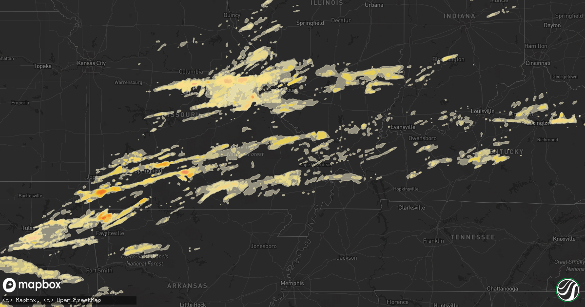
Hail Map in Missouri on April 22, 2011
Get this storm
April 22 map
$229
one time, instant access
Download today. No call, no setup
Keep the $229
Bought the map and want the full workflow? Apply the entire $229 to a subscription within 7 days. None of it is wasted.
Every map, not just this one
This buys you this map. Subscription and you get every map we run, in the markets you choose from a few cities to whole states to nationwide. Plus real-time alerts the moment a storm fires.
Contact data
Name, contact info, occupancy, even credit band for addresses in the footprint. You go from where it hit to who to call.
Become the source they trust
Unlimited branding weather history reports on demand. You already have the documented answer ready for the property owner, and you are the one who showed up with it.
Property data and RoofTrace estimates
Pull up any address you have got, its value and the exact code rules for that jurisdiction, straight from One Click Code. Then RoofTrace estimates the squares, pitch, and roof value, priced the way you price.
Storm reports in Missouri
Missouri
| Date | Description |
|---|---|
| 04/22/20116:58 PM CDT | A local report indicates 2.75 inch wind near WARRENTON |
| 04/22/20116:56 PM CDT | A local report indicates 1.75 inch wind near WALNUT GROVE |
| 04/22/20116:56 PM CDT | Penny to quarter sized hail. |
| 04/22/20116:55 PM CDT | A local report indicates 1.75 inch wind near WARRENTON |
| 04/22/20116:52 PM CDT | A local report indicates 4.50 inch wind near WARRENTON |
| 04/22/20116:50 PM CDT | A local report indicates 1.75 inch wind near 3 S WARRENTON |
| 04/22/20116:50 PM CDT | A local report indicates 1.00 inch wind near JONESBURG |
| 04/22/20116:48 PM CDT | A local report indicates 1.00 inch wind near WARRENTON |
| 04/22/20116:46 PM CDT | A local report indicates 1.00 inch wind near JONESBURG |
| 04/22/20116:44 PM CDT | A local report indicates 1.25 inch wind near WARRENTON |
| 04/22/20116:42 PM CDT | A local report indicates 1.25 inch wind near NIANGUA |
| 04/22/20116:42 PM CDT | A local report indicates 1.00 inch wind near 2 SE GREENFIELD |
| 04/22/20116:40 PM CDT | A local report indicates 1.75 inch wind near MARSHFIELD |
| 04/22/20116:38 PM CDT | 3 to 4 inch hail at hermann country club golf course |
| 04/22/20116:37 PM CDT | A local report indicates 1.00 inch wind near MARSHFIELD |
| 04/22/20116:37 PM CDT | A local report indicates 1.75 inch wind near LINN |
| 04/22/20116:36 PM CDT | A local report indicates 1.00 inch wind near MARSHFIELD |
| 04/22/20116:35 PM CDT | Observed 6 miles north of belle |
| 04/22/20116:35 PM CDT | A local report indicates 2.50 inch wind near 1 NE RHINELAND |
| 04/22/20116:35 PM CDT | A local report indicates 1.00 inch wind near MARSHFIELD |
| 04/22/20116:35 PM CDT | Numerous baseball to gragefruit size hailstones |
| 04/22/20116:33 PM CDT | A local report indicates 1.00 inch wind near 5 SE LINN |
| 04/22/20116:32 PM CDT | A local report indicates 2.75 inch wind near BIG SPRING |
| 04/22/20116:30 PM CDT | A local report indicates 2.75 inch wind near 4 N HERMANN |
| 04/22/20116:30 PM CDT | A local report indicates 1.75 inch wind near 10 S LINN |
| 04/22/20116:26 PM CDT | A local report indicates 1.00 inch wind near 3 E STRAFFORD |
| 04/22/20116:26 PM CDT | A local report indicates 1.75 inch wind near 4 E STRAFFORD |
| 04/22/20116:18 PM CDT | On hwy k along the callaway and montgomery county line |
| 04/22/20116:18 PM CDT | A local report indicates 1.25 inch wind near 3 E MONETT |
| 04/22/20116:16 PM CDT | A local report indicates 1.00 inch wind near 1 W STRAFFORD |
| 04/22/20116:15 PM CDT | Measured near the intersection of hwy hh and k |
| 04/22/20116:14 PM CDT | A local report indicates 1.00 inch wind near PORTLAND |
| 04/22/20116:10 PM CDT | A local report indicates 1.75 inch wind near 4 SW MONETT |
| 04/22/20116:07 PM CDT | I44 at 79 mile marker. |
| 04/22/20116:00 PM CDT | A local report indicates 1.00 inch wind near 4 WNW VERONA |
| 04/22/20115:52 PM CDT | A local report indicates 1.00 inch wind near 4 E NEWTONIA |
| 04/22/20115:51 PM CDT | Hail observed on highway 54 |
| 04/22/20115:47 PM CDT | A local report indicates 1.50 inch wind near 3 E NEW BLOOMFIELD |
| 04/22/20115:45 PM CDT | Report from law enforement relayed through emergency management |
| 04/22/20115:44 PM CDT | Reported at corner of norway street and monarch street. |
| 04/22/20115:35 PM CDT | A local report indicates 2.00 inch wind near 2 NE HARTSBURG |
| 04/22/20115:32 PM CDT | Report from ashland pd...relayed by columbia eoc |
| 04/22/20115:31 PM CDT | Reported at intersection of county road 1087 and county road 2010. |
| 04/22/20115:21 PM CDT | Report relayed through mo troop f |
| 04/22/20115:04 PM CDT | A local report indicates 2.50 inch wind near 8 N CALIFORNIA |
| 04/22/20115:00 PM CDT | A local report indicates 2.00 inch wind near 8 N CALIFORNIA |
| 04/22/20114:45 PM CDT | Fire chief collected tennis ball hail |
| 04/22/20113:50 PM CDT | One inch hail reported in purcell. |
| 04/22/201111:45 AM CDT | A local report indicates 1.25 inch wind near 1 SW FENTON |
| 04/22/201111:40 AM CDT | 1.25 inch hail...additionally some siding blown off mobile home. Although wind estimated to be less than 60 mph. |
| 04/22/201111:40 AM CDT | 1.25 inch hail...additionally some siding blown off mobile home. Although wind estimated to be less than 60 mph. |
| 04/22/201111:32 AM CDT | Hail lasted about two minutes at 270 and tesson ferry |
| 04/22/201111:13 AM CDT | A local report indicates 1.00 inch wind near 2 E ROBERTSVILLE |
| 04/22/201111:08 AM CDT | Mainly nickel sized...a few quarter sized hail stones |
| 04/22/201111:02 AM CDT | Hail observed in the town of anaconda |
| 04/22/201110:55 AM CDT | A local report indicates 1.00 inch wind near MARYLAND HEIGHTS |
| 04/22/201110:52 AM CDT | A local report indicates 1.00 inch wind near CREVE COEUR |
| 04/22/201110:47 AM CDT | A local report indicates 1.00 inch wind near 4 NW UNION |
| 04/22/201110:39 AM CDT | A local report indicates 1.00 inch wind near NEW HAVEN |
| 04/22/201110:30 AM CDT | A local report indicates 1.00 inch wind near OWENSVILLE |
| 04/22/201110:24 AM CDT | Hail just started. Report just east of rosebud on gasconade and franklin county lines. |
| 04/22/201110:15 AM CDT | A local report indicates 1.00 inch wind near OWENSVILLE |
| 04/22/201110:11 AM CDT | A local report indicates 1.00 inch wind near PERSHING |
| 04/22/201110:10 AM CDT | A local report indicates 1.00 inch wind near OWENSVILLE |
| 04/22/20119:55 AM CDT | A local report indicates 1.25 inch wind near 8 E LINN |
| 04/22/20119:25 AM CDT | Hail lasted about one minute |
| 04/22/20119:25 AM CDT | Hail lasted 2 minutes...ranged from nickel size to quarter size |
| 04/22/20119:25 AM CDT | East side of jefferson city. Lasted 3 to 4 minutes. |
| 04/22/20119:09 AM CDT | Media relayed a report from the public |
| 04/22/20119:02 AM CDT | A local report indicates 1.00 inch wind near CENTERTOWN |
| 04/22/20119:02 AM CDT | A local report indicates 1.00 inch wind near CENTER |
| 04/22/20117:05 AM CDT | A local report indicates 1.00 inch wind near LA PLATA |
| 04/22/20114:16 AM CDT | Public reports quarter sized hail |
| 04/22/20111:55 AM CDT | A local report indicates 1.00 inch wind near 1 S BRANSON WEST |
| 04/21/201110:48 PM CDT | Golf ball sized hail reported on joe bald rd. |
| 04/21/201110:48 PM CDT | Public reports several docks damaged along with several boats damaged and flip over in the lake. |
| 04/21/201110:31 PM CDT | A local report indicates 1.00 inch wind near ROGERSVILLE |
| 04/21/201110:25 PM CDT | Hail 1.75 to 2.00 inches in diameter with trees reported down. |
| 04/21/201110:23 PM CDT | A local report indicates 1.00 inch wind near 1 S NORWOOD |
| 04/21/201110:15 PM CDT | Fire dept reports baseball sized hail in maccomb. |
| 04/21/20119:35 PM CDT | 3 to 4 inch hail at hermann country club golf coarse |
| 04/21/20119:17 PM CDT | Numerous trees down. Also power lines down in oran and chaffee |
| 04/21/20119:04 PM CDT | 50 mph winds also reported |
| 04/21/20119:00 PM CDT | House trailer overturned and trees down in town |
| 04/21/20119:00 PM CDT | A local report indicates 1.00 inch wind near GRANDIN |
| 04/21/20118:53 PM CDT | Main terminal windows blown out at lambert airport....roof off of concourse c...and power outages |
| 04/21/20118:48 PM CDT | 2 large trees down...and many 1-5 inch limbs down |
| 04/21/20118:43 PM CDT | Air national guard building damaged...and structural damage to buildings at the airport...and cars flipped |
| 04/21/20118:37 PM CDT | A local report indicates 1.00 inch wind near 5 NE SPRINGFIELD |
| 04/21/20118:34 PM CDT | Tractor trailers standing on end. |
| 04/21/20118:32 PM CDT | Power lines down at i-70 and cyprus |
| 04/21/20118:25 PM CDT | Falling west and southwest of city limits |
| 04/21/20118:21 PM CDT | Chasers report damage and debris near exit 236 on i70...trees damaged...cell phone tower bent over...flag pole at airport bent over...interstate signs down and small de |
| 04/21/20118:18 PM CDT | Large tree fell through a home at 270 |
| 04/21/20118:15 PM CDT | Roof damge and entire 2nd floor gone off a church |
| 04/21/20118:15 PM CDT | At least one home damaged near chambers and west florrisant |
| 04/21/20118:14 PM CDT | Observer at stl reports tornado at lambert field moving east |
| 04/21/20118:10 PM CDT | Semi blown over at highway 70 and st charles rock road |
| 04/21/20118:09 PM CDT | Power lines and trees down at creve coeur mill and pritchard farm roads |
| 04/21/20118:04 PM CDT | Trees and power lines down at 2 miiles west of highway 270 and dorsett road |
| 04/21/20117:59 PM CDT | Trees and power lines down at 2 miiles west of highway 270 and dorsett road |
| 04/21/20117:56 PM CDT | Possible rain wrapped tornado. Debris observed in field off of highway 30 near st clair lonedell city limits |
| 04/21/20117:54 PM CDT | I-70 and cave springs |
| 04/21/20117:51 PM CDT | A local report indicates 1.75 inch wind near VILLA RIDGE |
| 04/21/20117:48 PM CDT | A local report indicates 70 MPH wind near ST. PETERS |
| 04/21/20117:46 PM CDT | A local report indicates 1.75 inch wind near ST. CLAIR |
| 04/21/20117:46 PM CDT | At exit 217 on i70 |
| 04/21/20117:45 PM CDT | 12 inch diameter tree fell onto a car on veterans memorial parkway between highway k and bryan road |
| 04/21/20117:44 PM CDT | Approximately 1 mile west of k and n |
| 04/21/20117:43 PM CDT | Near salt lick and i70 |
| 04/21/20117:42 PM CDT | A local report indicates 1.00 inch wind near SUCCESS |
| 04/21/20117:42 PM CDT | Quarter size hail and street flooding |
| 04/21/20117:41 PM CDT | Golf ball size hail at highway k and mexico road |
| 04/21/20117:40 PM CDT | A local report indicates 1.50 inch wind near 2 SSW O'FALLON |
| 04/21/20117:38 PM CDT | Long track of trees down... Power poles... And home damage |
| 04/21/20117:35 PM CDT | Trees reported downed into multiple directions along highway z to the north of bruner. |
| 04/21/20117:33 PM CDT | A local report indicates 1.50 inch wind near LAKE ST. LOUIS |
| 04/21/20117:33 PM CDT | A local report indicates 1.00 inch wind near 5 NE OZARK |
| 04/21/20117:30 PM CDT | Heavy structural damage at 122 auburn meadow drive |
| 04/21/20117:27 PM CDT | A local report indicates 1.75 inch wind near LAKE ST. LOUIS |
| 04/21/20117:26 PM CDT | A local report indicates 1.00 inch wind near WENTZVILLE |
| 04/21/20117:25 PM CDT | Dime to quarter size hail reported by sheriffs office |
| 04/21/20117:23 PM CDT | A local report indicates 1.25 inch wind near 4 E FORISTELL |
| 04/21/20117:14 PM CDT | A local report indicates 1.75 inch wind near WRIGHT CITY |
| 04/21/20117:14 PM CDT | A local report indicates 1.00 inch wind near OZARK |
| 04/21/20117:10 PM CDT | Spotter reported possible brief tornado touchdown. Lasted only a moment. |
| 04/21/20117:07 PM CDT | A local report indicates 1.00 inch wind near SUNSET HILLS |
| 04/21/20117:06 PM CDT | Highway u and tall oaks road |
| 04/21/20117:06 PM CDT | A tree was blown down one mile east of nixa on highway 14. |
| 04/21/20117:05 PM CDT | A local report indicates 1.75 inch wind near 2 SW NIXA |
| 04/21/20117:00 PM CDT | A local report indicates 4.50 inch wind near WARRENTON |
| 04/21/20117:00 PM CDT | A local report indicates 1.75 inch wind near WRIGHT CITY |
All States Impacted by Hail Map on April 22, 2011
Cities Impacted by Hail Map on April 22, 2011
- Ozone, AR
- Hagarville, AR
- Saint Paul, AR
- Ozark, AR
- Pettigrew, AR
- Combs, AR
- Oark, AR
- Deer, AR
- Mount Judea, AR
- Thornfield, MO
- Bridgeport, IL
- Lawrenceville, IL
- Flat Rock, IL
- Oblong, IL
- Robinson, IL
- Sumner, IL
- Claremont, IL
- Sandoval, IL
- Odin, IL
- Bristow, OK
- Linn, MO
- Morrison, MO
- Chamois, MO
- South Greenfield, MO
- Versailles, IL
- Springfield, KY
- Elkland, MO
- Buffalo, MO
- Fair Grove, MO
- Lampe, MO
- Muse, OK
- Noble, OK
- Wanette, OK
- Macomb, OK
- Lexington, OK
- Tecumseh, OK
- Shawnee, OK
- Norman, OK
- Mcloud, OK
- Maud, OK
- Newalla, OK
- Purcell, OK
- Wayne, OK
- Vinita, OK
- Shipman, IL
- Strafford, MO
- Marshfield, MO
- Barry, IL
- Baylis, IL
- Redbird, OK
- Coweta, OK
- Porter, OK
- Mounds, OK
- Bixby, OK
- Tulsa, OK
- Jenks, OK
- Broken Arrow, OK
- Glenpool, OK
- Sapulpa, OK
- Wright City, MO
- Truesdale, MO
- Warrenton, MO
- Marionville, MO
- Mountain Grove, MO
- Mansfield, MO
- Norwood, MO
- Drury, MO
- Macomb, MO
- Annada, MO
- Elsberry, MO
- Inola, OK
- Jamestown, MO
- California, MO
- Elnora, IN
- Plainville, IN
- Washington, IN
- Alton, MO
- Birch Tree, MO
- Miller, MO
- Sarcoxie, MO
- Stotts City, MO
- Joplin, MO
- La Russell, MO
- Carthage, MO
- Reeds, MO
- Lockwood, MO
- Diamond, MO
- Mount Vernon, MO
- Sulphur Springs, AR
- Gravette, AR
- Olney, IL
- Walnut Grove, MO
- Louisiana, MO
- Eufaula, OK
- Sullivan, MO
- Saint Clair, MO
- Rogers, AR
- Centerton, AR
- Bentonville, AR
- Decatur, AR
- Hiwasse, AR
- Fitzhugh, OK
- Bradley, OK
- Foster, OK
- Byars, OK
- Ada, OK
- Pauls Valley, OK
- Asher, OK
- Stonewall, OK
- Tupelo, OK
- Centrahoma, OK
- Maysville, OK
- Elmore City, OK
- Allen, OK
- Paoli, OK
- Lindsay, OK
- Wynnewood, OK
- Stratford, OK
- Roff, OK
- Rush Springs, OK
- Marlow, OK
- Hull, IL
- Smithland, KY
- Golconda, IL
- Greenfield, MO
- Fieldon, IL
- Terral, OK
- Petrolia, TX
- Wichita Falls, TX
- Ryan, OK
- Henrietta, TX
- Kingdom City, MO
- Auxvasse, MO
- Fulton, MO
- Edwardsport, IN
- Odon, IN
- Newberry, IN
- Bicknell, IN
- Altenburg, MO
- Jackson, MO
- Wolf Lake, IL
- Makanda, IL
- Carbondale, IL
- Alto Pass, IL
- Grand Tower, IL
- Pomona, IL
- Murphysboro, IL
- Cobden, IL
- Kinderhook, IL
- Summersville, KY
- Magnolia, KY
- Buffalo, KY
- Campbellsville, KY
- Mount Sherman, KY
- Greensburg, KY
- Ava, MO
- Wyandotte, OK
- Success, MO
- Huggins, MO
- Bucyrus, MO
- Plato, MO
- Marion, IL
- Shelbina, MO
- Thebes, IL
- Benton, MO
- Scott City, MO
- Chaffee, MO
- Exeter, MO
- Cassville, MO
- Hartford, KY
- Utica, KY
- Philpot, KY
- Whitesville, KY
- Eminence, MO
- Freeburg, MO
- Prague, OK
- Salem, IL
- Saint Peter, IL
- Farina, IL
- Kinmundy, IL
- Grandin, MO
- Monett, MO
- Granby, MO
- Pierce City, MO
- Stark City, MO
- Neosho, MO
- Stella, MO
- Goodman, MO
- Seneca, MO
- Purdy, MO
- Winchester, IL
- Bluffs, IL
- Bloomfield, MO
- Advance, MO
- Dunkirk, IN
- Montpelier, IN
- Portland, IN
- Pennville, IN
- Hartford City, IN
- New Canton, IL
- Upland, IN
- Rockford, OH
- Matthews, IN
- Frankton, IN
- Celina, OH
- Elwood, IN
- Geneva, IN
- Gaston, IN
- Summitville, IN
- Spencerville, OH
- Muncie, IN
- Mendon, OH
- Alexandria, IN
- Bryant, IN
- Fairmount, IN
- Wentworth, MO
- Wagoner, OK
- Jacksonville, IL
- Chapin, IL
- Pittsfield, IL
- Springdale, AR
- Kiefer, OK
- Muskogee, OK
- Hulbert, OK
- Fort Gibson, OK
- Lawton, OK
- Essex, MO
- Clarkson, KY
- Leitchfield, KY
- Everton, MO
- Niangua, MO
- Seymour, MO
- Rogersville, MO
- Springfield, MO
- Bokoshe, OK
- Sadieville, KY
- Midway, KY
- Stamping Ground, KY
- Georgetown, KY
- Frankfort, KY
- Raywick, KY
- Marion, KY
- Mauckport, IN
- Payneville, KY
- Battletown, KY
- Brandenburg, KY
- Eolia, MO
- Hamburg, IL
- Silex, MO
- Batchtown, IL
- Kampsville, IL
- Clarksville, MO
- Noble, IL
- Peotone, IL
- Paris, MO
- Saint Louis, MO
- Tebbetts, MO
- Jefferson City, MO
- Holts Summit, MO
- Corydon, IN
- Carterville, MO
- Webb City, MO
- Oronogo, MO
- Hardyville, KY
- Bee Spring, KY
- Bradfordsville, KY
- Munfordville, KY
- Bonnieville, KY
- Mammoth Cave, KY
- Canmer, KY
- Cub Run, KY
- Upton, KY
- Lebanon, KY
- Sonora, KY
- Horse Cave, KY
- New Haven, KY
- Hodgenville, KY
- Bowling Green, MO
- Middletown, MO
- Belgrade, MO
- Potosi, MO
- Anderson, MO
- Shirley, IN
- New Castle, IN
- Hartville, MO
- Grove, OK
- Tiff City, MO
- Beggs, OK
- Patoka, IL
- Carlyle, IL
- Alma, IL
- Cynthiana, KY
- Paris, KY
- Marshall, AR
- Stilwell, OK
- Westville, OK
- Colcord, OK
- Jay, OK
- Kansas, OK
- Belle, MO
- Walters, OK
- Iberia, MO
- Ulman, MO
- Vienna, MO
- Brinktown, MO
- Brumley, MO
- Dixon, MO
- Meta, MO
- Bland, MO
- Portage Des Sioux, MO
- Saint Charles, MO
- Marion, IN
- Poplar Bluff, MO
- Henryetta, OK
- Boley, OK
- Checotah, OK
- Porum, OK
- Stroud, OK
- Castle, OK
- Weleetka, OK
- Mccurtain, OK
- Sparks, OK
- Wetumka, OK
- Paden, OK
- Whitefield, OK
- Stigler, OK
- Kinta, OK
- Keota, OK
- Okemah, OK
- Okmulgee, OK
- Meeker, OK
- Edwards, MO
- Stover, MO
- Graff, MO
- Licking, MO
- Salem, MO
- Ash Grove, MO
- Bois D Arc, MO
- Halltown, MO
- Isabella, MO
- Rushville, IL
- Cave Springs, AR
- Gentry, AR
- Garfield, AR
- Bella Vista, AR
- Reeds Spring, MO
- Kimberling City, MO
- Branson, MO
- Shell Knob, MO
- Oakland City, IN
- Lynnville, IN
- West Frankfort, IL
- Benton, IL
- Sharpsburg, KY
- Carlisle, KY
- Mount Sterling, KY
- Grovespring, MO
- Haskell, OK
- Newton, IL
- Oaktown, IN
- Bruceville, IN
- Vincennes, IN
- Cuba, MO
- Henley, MO
- Saint Elizabeth, MO
- Poseyville, IN
- Wadesville, IN
- Mascoutah, IL
- Marissa, IL
- Locust Grove, OK
- Unionville, IN
- Nashville, IN
- Bloomington, IN
- Bristow, IN
- Branchville, IN
- Saint Croix, IN
- Berryville, AR
- Eureka Springs, AR
- Xenia, IL
- Lebanon, MO
- Phillipsburg, MO
- New Bloomfield, MO
- Mokane, MO
- Rhineland, MO
- Montgomery City, MO
- Hermann, MO
- New Florence, MO
- Jonesburg, MO
- Portland, MO
- Preston, MO
- Urbana, MO
- Pleasant Hope, MO
- Villa Ridge, MO
- Fenton, MO
- Leslie, MO
- Marthasville, MO
- New Haven, MO
- Rosebud, MO
- Wildwood, MO
- Augusta, MO
- Union, MO
- Arnold, MO
- Washington, MO
- Gray Summit, MO
- Beaufort, MO
- High Ridge, MO
- Owensville, MO
- Robertsville, MO
- Eureka, MO
- Gerald, MO
- Labadie, MO
- Pacific, MO
- Berger, MO
- Catawissa, MO
- House Springs, MO
- Imperial, MO
- Clarksburg, MO
- Chrisney, IN
- Gentryville, IN
- Prairie Home, MO
- Ashland, MO
- Centertown, MO
- Hartsburg, MO
- Fredericktown, MO
- Sainte Genevieve, MO
- Farmington, MO
- Perryville, MO
- Saint Mary, MO
- Wentzville, MO
- Foristell, MO
- Steedman, MO
- Williamsburg, MO
- Mount Sterling, MO
- High Hill, MO
- Chaplin, KY
- Lawrenceburg, KY
- Willisburg, KY
- Creal Springs, IL
- Ozark, IL
- New Burnside, IL
- Owingsville, KY
- Heavener, OK
- Waldron, AR
- Oakford, IL
- Charleston, MO
- Loveland, OK
- Grandfield, OK
- Devol, OK
- Geronimo, OK
- Cannelton, IN
- Derby, IN
- Morrisville, MO
- Aldrich, MO
- Wappapello, MO
- Greenville, MO
- Puxico, MO
- Gipsy, MO
- Zalma, MO
- McGee, MO
- Lake Saint Louis, MO
- O'Fallon, MO
- Saint Peters, MO
- Guyton, GA
- Mooreland, IN
- Madison, MO
- Whitewater, MO
- Marble Hill, MO
- Burfordville, MO
- Conway, MO
- Belleview, MO
- Duncan, OK
- Clinton, AR
- Mountainburg, AR
- Arcadia, IN
- Golden City, MO
- Siloam Springs, AR
- Catoosa, OK
- Claremore, OK
- Cairo, IL
- Bridgeton, MO
- Maryland Heights, MO
- Florissant, MO
- Warsaw, MO
- Wellington, KY
- Morehead, KY
- West Liberty, KY
- Rockwood, IL
- Ava, IL
- McLean, IL
- Bismarck, MO
- Park Hills, MO
- Doe Run, MO
- Ironton, MO
- Ellsinore, MO
- Fort Branch, IN
- Lonedell, MO
- Waterloo, IL
- Valmeyer, IL
- Winona, MO
- Mount Eden, KY
- Fisherville, KY
- Shelbyville, KY
- Finchville, KY
- Waddy, KY
- Taylorsville, KY
- Lexington, KY
- Versailles, KY
- Louisville, KY
- Frohna, MO
- Uniontown, MO
- Anna, IL
- Buncombe, IL
- Bunker Hill, IL
- Alton, IL
- Godfrey, IL
- Brighton, IL
- Honobia, OK
- Energy, IL
- Watson, OK
- Sturdivant, MO
- Brownwood, MO
- Central, IN
- Elizabeth, IN
- Laconia, IN
- Lenox, MO
- Houston, MO
- Eldred, IL
- Vandalia, IL
- Smithboro, IL
- Mulberry Grove, IL
- Carmi, IL
- Otterville, MO
- Smithton, MO
- Bonnots Mill, MO
- Rose, OK
- Twin Oaks, OK
- Westphalia, MO
- Koeltztown, MO
- Yorktown, IN
- Troy, MO
- Clay City, IL
- Olive Hill, KY
- Grayson, KY
- Fults, IL
- Festus, MO
- Comanche, OK
- Temple, OK
- Hastings, OK
- Waurika, OK
- Ozark, MO
- Nixa, MO
- Tahlequah, OK
- Hopkinsville, KY
- White Plains, KY
- Greenville, KY
- Crofton, KY
- Tuskahoma, OK
- Talihina, OK
- Roach, MO
- Camdenton, MO
- Brussels, IL
- Fortuna, MO
- New Harmony, IN
- Nebo, IL
- Pittsburg, OK
- Broughton, IL
- Pryor, OK
- Edwardsville, IL
- Winchester, IN
- Lynn, IN
- Modoc, IN
- Hartford, IL
- East Alton, IL
- South Roxana, IL
- Ledbetter, KY
- Brookport, IL
- Paducah, KY
- Dover, AR
- West Plains, MO
- Peace Valley, MO
- Leopold, IN
- Tell City, IN
- Matthews, MO
- Sasakwa, OK
- Holdenville, OK
- Mount Erie, IL
- Norris City, IL
- Enfield, IL
- Berry, KY
- Corinth, KY
- Sedgewickville, MO
- Wilkinson, IN
- Markleville, IN
- Eagle Rock, MO
- Aurora, MO
- Verona, MO
- Griggsville, IL
- Farmington, AR
- Blanco, OK
- Hartshorne, OK
- Mount Sterling, IL
- Frankford, MO
- McClure, IL
- Dongola, IL
- Jonesboro, IL
- Cape Girardeau, MO
- Yellville, AR
- Oakland, AR
- Peel, AR
- Pontiac, MO
- Salt Lick, KY
- Lowell, AR
- Watts, OK
- Maysville, AR
- Lincoln, AR
- Hindsville, AR
- Proctor, OK
- Peggs, OK
- Chouteau, OK
- Golden, MO
- Welling, OK
- Fayetteville, AR
- Kellyville, OK
- Spavinaw, OK
- Pineville, MO
- Oaks, OK
- Pea Ridge, AR
- Salina, OK
- Summers, AR
- Canehill, AR
- Cromwell, KY
- Beaver Dam, KY
- Grantsburg, IL
- Glendale, KY
- Gorham, IL
- Vergennes, IL
- Climax Springs, MO
- Hardin, IL
- Pelsor, AR
- Mulkeytown, IL
- Royalton, IL
- Zeigler, IL
- Pevely, MO
- Barnhart, MO
- Witts Springs, AR
- Coxs Creek, KY
- Payson, IL
- Liberty, IL
- Vandalia, MO
- Black, MO
- Chesterfield, MO
- Hodgen, OK
- Monee, IL
- Montgomery, IN
- New Salisbury, IN
- Springfield, GA
- Greenville, IL
- Mountain View, MO
- Pomona, MO
- Pottersville, MO
- English, IN
- French Lick, IN
- Daisy, OK
- Stringtown, OK
- Crossville, IL
- Macks Creek, MO
- Rosiclare, IL
- Leavenworth, IN
- Macedonia, IL
- McLeansboro, IL
- Logan, IL
- Galatia, IL
- Thompsonville, IL
- Alhambra, IL
- Barlow, KY
- La Center, KY
- Kevil, KY
- Highlandville, MO
- Cabool, MO
- Fordland, MO
- Miami, OK
- Crane, MO
- Vanzant, MO
- Billings, MO
- Clever, MO
- Fairland, OK
- Fairview, MO
- Sparta, MO
- Breese, IL
- Theodosia, MO
- Noble, MO
- Noel, MO
- Winchester, KY
- Leslie, AR
- Fox, AR
- Defiance, MO
- Ellington, MO
- Redford, MO
- West Liberty, IL
- Sainte Marie, IL
- Willow Hill, IL
- Louisville, IL
- Dieterich, IL
- Stoy, IL
- Dundas, IL
- Palestine, IL
- Iuka, IL
- Ingraham, IL
- Brownstown, IL
- Edgewood, IL
- Mason, IL
- Wheeler, IL
- Shobonier, IL
- Morgantown, KY
- Caneyville, KY
- Morganfield, KY
- Sturgis, KY
- Bloomfield, IN
- Clayton, IL
- Falcon, MO
- Marine, IL
- Bloomfield, KY
- Astoria, IL
- Vermont, IL
- Lowndes, MO
- Glen Carbon, IL
- Solo, MO
- Caledonia, MO
- Willard, MO
- Campbell Hill, IL
- Duenweg, MO
- Lesterville, MO
- Lamar, MO
- Yukon, MO
- Jasper, MO
- Jacob, IL
- Edgar Springs, MO
- De Soto, IL
- Bolivar, MO
- Elk Creek, MO
- Summersville, MO
- Eunice, MO
- Brighton, MO
- Afton, OK
- Jadwin, MO
- Bunker, MO
- Boss, MO
- Long Lane, MO
- Raymondville, MO
- Beulah, MO
- Bruner, MO
- Hartshorn, MO
- Bixby, MO
- Elkville, IL
- Dadeville, MO
- Centerville, MO
- Nashoba, OK
- Clayton, OK
- Jeffersonville, KY
- Syracuse, MO
- West Alton, MO
- Argyle, MO
- Dorsey, IL
- Jerseyville, IL
- Bethalto, IL
- Tipton, MO
- Piasa, IL
- Golden Eagle, IL
- Grafton, IL
- Loose Creek, MO
- Hazelwood, MO
- Florence, MO
- Fidelity, IL
- Bunceton, MO
- Dow, IL
- Elsah, IL
- Atlanta, IN
- Sulphur, OK
- Davis, OK
- Harrison, AR
- Evanston, IN
- Steelville, MO
- Cedar Hill, MO
- Columbia, MO
- Earth City, MO
- Saint Thomas, MO
- Moscow Mills, MO
- Saint Ann, MO
- Ballwin, MO
- Valley Park, MO
- White Hall, IL
- Hillview, IL
- Roodhouse, IL
- Mansfield, AR
- Mena, AR
- Huntington, AR
- Hartford, AR
- Booneville, AR
- Smithville, OK
- Granite City, IL
- Morocco, IN
- Albion, OK
- Rockport, KY
- Rueter, MO
- Carrollton, IL
- Huntsville, MO
- Moberly, MO
- Cairo, MO
- Fremont, MO
- Van Buren, MO
- Olympia, KY
- Columbus, IN
- Center, MO
- Bourbon, MO
- Frederick, OK
- Byers, TX
- Willow Springs, MO
- Caulfield, MO
- Gravois Mills, MO
- Winfield, MO
- Foley, MO
- Flemington, MO
- Sulphur, IN
- Cross Timbers, MO
- Big Cabin, OK
- Roxana, IL
- Moro, IL
- Worden, IL
- Wood River, IL
- Middletown, IN
- Vichy, MO
- Mcalester, OK
- Wilburton, OK
- Kiowa, OK
- Concord, IL
- Meredosia, IL
- Glasford, IL
- Cuba, IL
- Canton, IL
- Lewistown, IL
- Villa Ridge, IL
- Ramsey, IL
- Shepherdsville, KY
- Kuttawa, KY
- Princeton, KY
- Eddyville, KY
- Sikeston, MO
- Bell City, MO
- Oran, MO
- Vanduser, MO
- Camden, IL
- Littleton, IL
- Collinsville, IL
- Lebanon, IL
- Troy, IL
- Saint Jacob, IL
- Eldon, MO
- Lake Ozark, MO
- Hermitage, MO
- Staunton, IL
- Randlett, OK
- Chattanooga, OK
- Hillsboro, MO
- Millstadt, IL
- Crystal City, MO
- Addieville, IL
- Saint Libory, IL
- New Athens, IL
- Freeburg, IL
- New Baden, IL
- Lenzburg, IL
- Columbia, IL
- Hecker, IL
- Belleville, IL
- Smithton, IL
- Herculaneum, MO
- Okawville, IL
- Red Bud, IL
- Eddyville, IL
- Stonefort, IL
- Mill Spring, MO
- Williamsville, MO
- Losantville, IN
- Hagerstown, IN
- Sedalia, MO
- Park Hill, OK
- Clay, KY
- Salem, KY
- Dixon, KY
- New Haven, IL
- Shawneetown, IL
- Flemingsburg, KY
- Salisbury, MO
- Dalton, MO
- Slater, MO
- Keytesville, MO
- Calvert City, KY
- Kouts, IN
- La Crosse, IN
- Fort Wayne, IN
- Falmouth, KY
- Tishomingo, OK
- Elizabethtown, KY
- Lebanon Junction, KY
- West Point, KY
- Wister, OK
- Antlers, OK
- Solsberry, IN
- Altamont, IL
- Beecher City, IL
- Saint Elmo, IL
- Hennepin, OK
- Rinard, IL
- Broken Bow, OK
- Dora, MO
- Demotte, IN
- Strang, OK
- Adair, OK
- Calhoun, IL
- Sailor Springs, IL
- Merom, IN
- Fillmore, IL
- Centralia, IL
- Donnellson, IL
- Pocahontas, IL
- Vernon, IL
- Coffeen, IL
- Big Clifty, KY
- White Mills, KY
- Cecilia, KY
- Eastview, KY
- Ridgeland, SC
- Tillman, SC
- Loretto, KY
- Statesboro, GA
- Wasola, MO
- Brixey, MO
- Venice, IL
- Zanoni, MO
- Seminole, OK
- Eldorado, IL
- Calhoun, KY
- Gainesville, MO
- Caseyville, IL
- Fairview Heights, IL
- O'Fallon, IL
- Bellflower, MO
- Truxton, MO
- Timewell, IL
- Hoyleton, IL
- Lead Hill, AR
- Quapaw, OK
- Livermore, KY
- Rumsey, KY
- Fordsville, KY
- Boonville, IN
- Tennyson, IN
- Elizabethtown, IL
- Cedarcreek, MO
- Humansville, MO
- Goreville, IL
- Holland, MI
- Bagdad, KY
- Bardstown, KY
- Germantown, IL
- Bartelso, IL
- Clarksville, AR
- Hawk Point, MO
- Old Monroe, MO
- Medora, IL
- Galena, MO
- Cape Fair, MO
- Horse Branch, KY
- West Paducah, KY
- Wickliffe, KY
- Mounds, IL
- Metropolis, IL
- Miller City, IL
- Mound City, IL
- Symsonia, KY
- Depew, OK
- Ashland, IL
- Tallula, IL
- Petersburg, IL
- Birdseye, IN
- Bethel, OK
- Piedmont, MO
- Thayer, MO
- Doniphan, MO
- Koshkonong, MO
- Oak Grove, AR
- Wallingford, KY
- Mountain View, AR
- Depauw, IN
- Cypress, IL
- Owensboro, KY
- Fittstown, OK
- Fletcher, OK
- Konawa, OK
- Mill Creek, OK
- Coalgate, OK
- Faxon, OK
- Litchfield, IL
- De Soto, MO
- Blue Eye, MO
- Ridgedale, MO
- Hollister, MO
- Gillespie, IL
- Green Ridge, MO
- Highland, IL
- Lyons, IN
- Sandborn, IN
- Hillsboro, KY
- Keystone, IN
- Palmyra, MO
- Monroe City, MO
- Rolla, MO
- Brooklet, GA
- Bellflower, IL
- Chambersburg, IL
- Saint James, MO
- Johnston City, IL
- Friedheim, MO
- Oak Ridge, MO
- Simpson, IL
- Vienna, IL
- Martinsburg, MO
- Hustonville, KY
- Ullin, IL
- Elkins, AR
- Winslow, AR
- Harviell, MO
- Pleasant Hill, IL
- Sorento, IL
- Walshville, IL
- Omaha, IL
- Ridgway, IL
- Patton, MO
- Grand Rivers, KY
- Broseley, MO
- Fisk, MO
- Owenton, KY
- Centertown, KY
- Lamar, IN
- Plainville, IL
- Buchanan, MI
- Berrien Springs, MI
- Niles, MI
- Galien, MI
- Switz City, IN
- Sylvania, GA
- Newington, GA
- Hannibal, MO
- Flora, IL
- Palmyra, IN
- Wardville, OK
- Herod, IL
- Cave In Rock, IL
- Sunrise Beach, MO
- Rocky Mount, MO
- Saint Catharine, KY
- New Hope, KY
- Santa Claus, IN
- Ekron, KY
- Washburn, MO
- Millersville, MO
- Protem, MO
- Perrysburg, OH
- Luckey, OH
- Sullivan, IN
- Carlisle, IN
- Hanna, OK
- Wewoka, OK
- Earlsboro, OK
- Quinton, OK
- Brunswick, MO
- Valles Mines, MO
- French Village, MO
- Bonne Terre, MO
- Mount Vernon, IN
- Graytown, OH
- Elmore, OH
- Pleasureville, KY
- Lockport, KY
- Bethlehem, KY
- Linton, IN
- Blackburn, MO
- Alma, MO
- Ewing, KY
- Wheatfield, IN
- Eugene, MO
- Wilsonville, IL
- Livingston, IL
- Benld, IL
- Wellsville, MO
- Dittmer, MO
- Lovejoy, IL
- East Saint Louis, IL
- Lohman, MO
- New Douglas, IL
- Mount Olive, IL
- East Carondelet, IL
- Cottage Hills, IL
- Russellville, MO
- Nashville, IL
- Kane, IL
- Chelsea, OK
- Rockport, IL
- Arrowsmith, IL
- Simpsonville, KY
- Eucha, OK
- Chester, AR
- Frenchburg, KY


