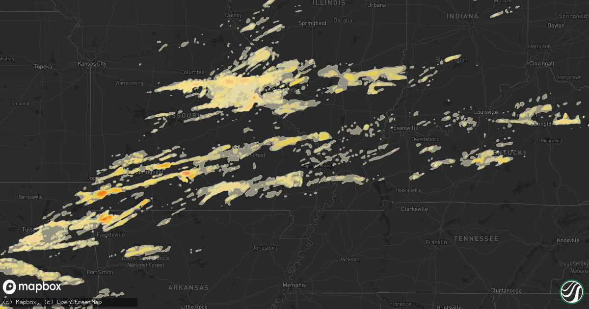
Hail Map in Kentucky on April 22, 2011
Get this storm
April 22 map
$229
one time, instant access
Download today. No call, no setup
Keep the $229
Bought the map and want the full workflow? Apply the entire $229 to a subscription within 7 days. None of it is wasted.
Every map, not just this one
This buys you this map. Subscription and you get every map we run, in the markets you choose from a few cities to whole states to nationwide. Plus real-time alerts the moment a storm fires.
Contact data
Name, contact info, occupancy, even credit band for addresses in the footprint. You go from where it hit to who to call.
Become the source they trust
Unlimited branding weather history reports on demand. You already have the documented answer ready for the property owner, and you are the one who showed up with it.
Property data and RoofTrace estimates
Pull up any address you have got, its value and the exact code rules for that jurisdiction, straight from One Click Code. Then RoofTrace estimates the squares, pitch, and roof value, priced the way you price.
Storm reports in Kentucky
Kentucky
| Date | Description |
|---|---|
| 04/22/20116:23 PM CDT | Lex18 reports damage and a window blown out on romany road in the chevy chase area |
| 04/22/20116:13 PM CDT | An nws storm survey confirmed that an ef-0 tornado with estimated winds of 65 mph touched down 4 miles east of versailles. The 40 yard wide tornado was on the ground fo |
| 04/22/20116:12 PM CDT | Lex18 reports damage to trees and fences on marcellus drive |
| 04/22/20116:07 PM CDT | An nws storm survey confirmed an ef-0 tornado touched down 1 mile southeast of versailles in woodford county. The 60 yard wide tornado touched down at 707 pm edt causin |
| 04/22/20115:23 PM CDT | A local report indicates 1.00 inch wind near 8 S SHELBYVILLE |
| 04/22/20116:45 AM CDT | A few trees down |
| 04/22/20116:35 AM CDT | Multiple trees reported down around the city of ashland |
| 04/22/20116:30 AM CDT | Multiple trees and powerlines down throughout greenup county |
| 04/22/20116:25 AM CDT | Large branches broken. |
| 04/22/20115:50 AM CDT | One tree was reported down. |
| 04/22/20115:48 AM CDT | One tree down on park lake road |
| 04/22/20115:19 AM CDT | A local report indicates 1.00 inch wind near 5 S CYNTHIANA |
| 04/22/20115:09 AM CDT | An nws storm survey confirmed an ef-0 tornado with winds of 85 mph touched down about 1.5 miles east of connersville and remained on the ground for a quarter to half a |
| 04/22/20115:00 AM CDT | Hwy 525 south. |
| 04/22/20114:39 AM CDT | A local report indicates 1.00 inch wind near FRANKFORT |
| 04/22/20111:15 AM CDT | Trained spotter reports 1 to 1.5 inch hail |
| 04/22/201112:07 AM CDT | Tree down on us 31w |
| 04/21/201111:32 PM CDT | Tree down on ky 228 |
| 04/21/201111:27 PM CDT | Power lines down |
| 04/21/201111:07 PM CDT | Just north of webster-henderson county line on north end of poole. Multiple houses damaged and at least 1 with roof off. Numerous trees and powerlines down. |
| 04/21/20119:45 PM CDT | Partial roof and siding off residence. Also...window out of car |
| 04/21/20117:45 PM CDT | A local report indicates 1.75 inch wind near SALT LICK |
| 04/21/20117:37 PM CDT | Quarter size hail was reported on hwy 36 just south of owingsville. |
| 04/21/20117:13 PM CDT | A local report indicates 1.75 inch wind near 1 WSW SIDEVIEW |
| 04/21/20117:08 PM CDT | Golf ball sized hail reported on the border between clark... Bourbon... And montgomery counties. |
All States Impacted by Hail Map on April 22, 2011
Cities Impacted by Hail Map on April 22, 2011
- Ozone, AR
- Hagarville, AR
- Saint Paul, AR
- Ozark, AR
- Pettigrew, AR
- Combs, AR
- Oark, AR
- Deer, AR
- Mount Judea, AR
- Thornfield, MO
- Bridgeport, IL
- Lawrenceville, IL
- Flat Rock, IL
- Oblong, IL
- Robinson, IL
- Sumner, IL
- Claremont, IL
- Sandoval, IL
- Odin, IL
- Bristow, OK
- Linn, MO
- Morrison, MO
- Chamois, MO
- South Greenfield, MO
- Versailles, IL
- Springfield, KY
- Elkland, MO
- Buffalo, MO
- Fair Grove, MO
- Lampe, MO
- Muse, OK
- Noble, OK
- Wanette, OK
- Macomb, OK
- Lexington, OK
- Tecumseh, OK
- Shawnee, OK
- Norman, OK
- Mcloud, OK
- Maud, OK
- Newalla, OK
- Purcell, OK
- Wayne, OK
- Vinita, OK
- Shipman, IL
- Strafford, MO
- Marshfield, MO
- Barry, IL
- Baylis, IL
- Redbird, OK
- Coweta, OK
- Porter, OK
- Mounds, OK
- Bixby, OK
- Tulsa, OK
- Jenks, OK
- Broken Arrow, OK
- Glenpool, OK
- Sapulpa, OK
- Wright City, MO
- Truesdale, MO
- Warrenton, MO
- Marionville, MO
- Mountain Grove, MO
- Mansfield, MO
- Norwood, MO
- Drury, MO
- Macomb, MO
- Annada, MO
- Elsberry, MO
- Inola, OK
- Jamestown, MO
- California, MO
- Elnora, IN
- Plainville, IN
- Washington, IN
- Alton, MO
- Birch Tree, MO
- Miller, MO
- Sarcoxie, MO
- Stotts City, MO
- Joplin, MO
- La Russell, MO
- Carthage, MO
- Reeds, MO
- Lockwood, MO
- Diamond, MO
- Mount Vernon, MO
- Sulphur Springs, AR
- Gravette, AR
- Olney, IL
- Walnut Grove, MO
- Louisiana, MO
- Eufaula, OK
- Sullivan, MO
- Saint Clair, MO
- Rogers, AR
- Centerton, AR
- Bentonville, AR
- Decatur, AR
- Hiwasse, AR
- Fitzhugh, OK
- Bradley, OK
- Foster, OK
- Byars, OK
- Ada, OK
- Pauls Valley, OK
- Asher, OK
- Stonewall, OK
- Tupelo, OK
- Centrahoma, OK
- Maysville, OK
- Elmore City, OK
- Allen, OK
- Paoli, OK
- Lindsay, OK
- Wynnewood, OK
- Stratford, OK
- Roff, OK
- Rush Springs, OK
- Marlow, OK
- Hull, IL
- Smithland, KY
- Golconda, IL
- Greenfield, MO
- Fieldon, IL
- Terral, OK
- Petrolia, TX
- Wichita Falls, TX
- Ryan, OK
- Henrietta, TX
- Kingdom City, MO
- Auxvasse, MO
- Fulton, MO
- Edwardsport, IN
- Odon, IN
- Newberry, IN
- Bicknell, IN
- Altenburg, MO
- Jackson, MO
- Wolf Lake, IL
- Makanda, IL
- Carbondale, IL
- Alto Pass, IL
- Grand Tower, IL
- Pomona, IL
- Murphysboro, IL
- Cobden, IL
- Kinderhook, IL
- Summersville, KY
- Magnolia, KY
- Buffalo, KY
- Campbellsville, KY
- Mount Sherman, KY
- Greensburg, KY
- Ava, MO
- Wyandotte, OK
- Success, MO
- Huggins, MO
- Bucyrus, MO
- Plato, MO
- Marion, IL
- Shelbina, MO
- Thebes, IL
- Benton, MO
- Scott City, MO
- Chaffee, MO
- Exeter, MO
- Cassville, MO
- Hartford, KY
- Utica, KY
- Philpot, KY
- Whitesville, KY
- Eminence, MO
- Freeburg, MO
- Prague, OK
- Salem, IL
- Saint Peter, IL
- Farina, IL
- Kinmundy, IL
- Grandin, MO
- Monett, MO
- Granby, MO
- Pierce City, MO
- Stark City, MO
- Neosho, MO
- Stella, MO
- Goodman, MO
- Seneca, MO
- Purdy, MO
- Winchester, IL
- Bluffs, IL
- Bloomfield, MO
- Advance, MO
- Dunkirk, IN
- Montpelier, IN
- Portland, IN
- Pennville, IN
- Hartford City, IN
- New Canton, IL
- Upland, IN
- Rockford, OH
- Matthews, IN
- Frankton, IN
- Celina, OH
- Elwood, IN
- Geneva, IN
- Gaston, IN
- Summitville, IN
- Spencerville, OH
- Muncie, IN
- Mendon, OH
- Alexandria, IN
- Bryant, IN
- Fairmount, IN
- Wentworth, MO
- Wagoner, OK
- Jacksonville, IL
- Chapin, IL
- Pittsfield, IL
- Springdale, AR
- Kiefer, OK
- Muskogee, OK
- Hulbert, OK
- Fort Gibson, OK
- Lawton, OK
- Essex, MO
- Clarkson, KY
- Leitchfield, KY
- Everton, MO
- Niangua, MO
- Seymour, MO
- Rogersville, MO
- Springfield, MO
- Bokoshe, OK
- Sadieville, KY
- Midway, KY
- Stamping Ground, KY
- Georgetown, KY
- Frankfort, KY
- Raywick, KY
- Marion, KY
- Mauckport, IN
- Payneville, KY
- Battletown, KY
- Brandenburg, KY
- Eolia, MO
- Hamburg, IL
- Silex, MO
- Batchtown, IL
- Kampsville, IL
- Clarksville, MO
- Noble, IL
- Peotone, IL
- Paris, MO
- Saint Louis, MO
- Tebbetts, MO
- Jefferson City, MO
- Holts Summit, MO
- Corydon, IN
- Carterville, MO
- Webb City, MO
- Oronogo, MO
- Hardyville, KY
- Bee Spring, KY
- Bradfordsville, KY
- Munfordville, KY
- Bonnieville, KY
- Mammoth Cave, KY
- Canmer, KY
- Cub Run, KY
- Upton, KY
- Lebanon, KY
- Sonora, KY
- Horse Cave, KY
- New Haven, KY
- Hodgenville, KY
- Bowling Green, MO
- Middletown, MO
- Belgrade, MO
- Potosi, MO
- Anderson, MO
- Shirley, IN
- New Castle, IN
- Hartville, MO
- Grove, OK
- Tiff City, MO
- Beggs, OK
- Patoka, IL
- Carlyle, IL
- Alma, IL
- Cynthiana, KY
- Paris, KY
- Marshall, AR
- Stilwell, OK
- Westville, OK
- Colcord, OK
- Jay, OK
- Kansas, OK
- Belle, MO
- Walters, OK
- Iberia, MO
- Ulman, MO
- Vienna, MO
- Brinktown, MO
- Brumley, MO
- Dixon, MO
- Meta, MO
- Bland, MO
- Portage Des Sioux, MO
- Saint Charles, MO
- Marion, IN
- Poplar Bluff, MO
- Henryetta, OK
- Boley, OK
- Checotah, OK
- Porum, OK
- Stroud, OK
- Castle, OK
- Weleetka, OK
- Mccurtain, OK
- Sparks, OK
- Wetumka, OK
- Paden, OK
- Whitefield, OK
- Stigler, OK
- Kinta, OK
- Keota, OK
- Okemah, OK
- Okmulgee, OK
- Meeker, OK
- Edwards, MO
- Stover, MO
- Graff, MO
- Licking, MO
- Salem, MO
- Ash Grove, MO
- Bois D Arc, MO
- Halltown, MO
- Isabella, MO
- Rushville, IL
- Cave Springs, AR
- Gentry, AR
- Garfield, AR
- Bella Vista, AR
- Reeds Spring, MO
- Kimberling City, MO
- Branson, MO
- Shell Knob, MO
- Oakland City, IN
- Lynnville, IN
- West Frankfort, IL
- Benton, IL
- Sharpsburg, KY
- Carlisle, KY
- Mount Sterling, KY
- Grovespring, MO
- Haskell, OK
- Newton, IL
- Oaktown, IN
- Bruceville, IN
- Vincennes, IN
- Cuba, MO
- Henley, MO
- Saint Elizabeth, MO
- Poseyville, IN
- Wadesville, IN
- Mascoutah, IL
- Marissa, IL
- Locust Grove, OK
- Unionville, IN
- Nashville, IN
- Bloomington, IN
- Bristow, IN
- Branchville, IN
- Saint Croix, IN
- Berryville, AR
- Eureka Springs, AR
- Xenia, IL
- Lebanon, MO
- Phillipsburg, MO
- New Bloomfield, MO
- Mokane, MO
- Rhineland, MO
- Montgomery City, MO
- Hermann, MO
- New Florence, MO
- Jonesburg, MO
- Portland, MO
- Preston, MO
- Urbana, MO
- Pleasant Hope, MO
- Villa Ridge, MO
- Fenton, MO
- Leslie, MO
- Marthasville, MO
- New Haven, MO
- Rosebud, MO
- Wildwood, MO
- Augusta, MO
- Union, MO
- Arnold, MO
- Washington, MO
- Gray Summit, MO
- Beaufort, MO
- High Ridge, MO
- Owensville, MO
- Robertsville, MO
- Eureka, MO
- Gerald, MO
- Labadie, MO
- Pacific, MO
- Berger, MO
- Catawissa, MO
- House Springs, MO
- Imperial, MO
- Clarksburg, MO
- Chrisney, IN
- Gentryville, IN
- Prairie Home, MO
- Ashland, MO
- Centertown, MO
- Hartsburg, MO
- Fredericktown, MO
- Sainte Genevieve, MO
- Farmington, MO
- Perryville, MO
- Saint Mary, MO
- Wentzville, MO
- Foristell, MO
- Steedman, MO
- Williamsburg, MO
- Mount Sterling, MO
- High Hill, MO
- Chaplin, KY
- Lawrenceburg, KY
- Willisburg, KY
- Creal Springs, IL
- Ozark, IL
- New Burnside, IL
- Owingsville, KY
- Heavener, OK
- Waldron, AR
- Oakford, IL
- Charleston, MO
- Loveland, OK
- Grandfield, OK
- Devol, OK
- Geronimo, OK
- Cannelton, IN
- Derby, IN
- Morrisville, MO
- Aldrich, MO
- Wappapello, MO
- Greenville, MO
- Puxico, MO
- Gipsy, MO
- Zalma, MO
- McGee, MO
- Lake Saint Louis, MO
- O'Fallon, MO
- Saint Peters, MO
- Guyton, GA
- Mooreland, IN
- Madison, MO
- Whitewater, MO
- Marble Hill, MO
- Burfordville, MO
- Conway, MO
- Belleview, MO
- Duncan, OK
- Clinton, AR
- Mountainburg, AR
- Arcadia, IN
- Golden City, MO
- Siloam Springs, AR
- Catoosa, OK
- Claremore, OK
- Cairo, IL
- Bridgeton, MO
- Maryland Heights, MO
- Florissant, MO
- Warsaw, MO
- Wellington, KY
- Morehead, KY
- West Liberty, KY
- Rockwood, IL
- Ava, IL
- McLean, IL
- Bismarck, MO
- Park Hills, MO
- Doe Run, MO
- Ironton, MO
- Ellsinore, MO
- Fort Branch, IN
- Lonedell, MO
- Waterloo, IL
- Valmeyer, IL
- Winona, MO
- Mount Eden, KY
- Fisherville, KY
- Shelbyville, KY
- Finchville, KY
- Waddy, KY
- Taylorsville, KY
- Lexington, KY
- Versailles, KY
- Louisville, KY
- Frohna, MO
- Uniontown, MO
- Anna, IL
- Buncombe, IL
- Bunker Hill, IL
- Alton, IL
- Godfrey, IL
- Brighton, IL
- Honobia, OK
- Energy, IL
- Watson, OK
- Sturdivant, MO
- Brownwood, MO
- Central, IN
- Elizabeth, IN
- Laconia, IN
- Lenox, MO
- Houston, MO
- Eldred, IL
- Vandalia, IL
- Smithboro, IL
- Mulberry Grove, IL
- Carmi, IL
- Otterville, MO
- Smithton, MO
- Bonnots Mill, MO
- Rose, OK
- Twin Oaks, OK
- Westphalia, MO
- Koeltztown, MO
- Yorktown, IN
- Troy, MO
- Clay City, IL
- Olive Hill, KY
- Grayson, KY
- Fults, IL
- Festus, MO
- Comanche, OK
- Temple, OK
- Hastings, OK
- Waurika, OK
- Ozark, MO
- Nixa, MO
- Tahlequah, OK
- Hopkinsville, KY
- White Plains, KY
- Greenville, KY
- Crofton, KY
- Tuskahoma, OK
- Talihina, OK
- Roach, MO
- Camdenton, MO
- Brussels, IL
- Fortuna, MO
- New Harmony, IN
- Nebo, IL
- Pittsburg, OK
- Broughton, IL
- Pryor, OK
- Edwardsville, IL
- Winchester, IN
- Lynn, IN
- Modoc, IN
- Hartford, IL
- East Alton, IL
- South Roxana, IL
- Ledbetter, KY
- Brookport, IL
- Paducah, KY
- Dover, AR
- West Plains, MO
- Peace Valley, MO
- Leopold, IN
- Tell City, IN
- Matthews, MO
- Sasakwa, OK
- Holdenville, OK
- Mount Erie, IL
- Norris City, IL
- Enfield, IL
- Berry, KY
- Corinth, KY
- Sedgewickville, MO
- Wilkinson, IN
- Markleville, IN
- Eagle Rock, MO
- Aurora, MO
- Verona, MO
- Griggsville, IL
- Farmington, AR
- Blanco, OK
- Hartshorne, OK
- Mount Sterling, IL
- Frankford, MO
- McClure, IL
- Dongola, IL
- Jonesboro, IL
- Cape Girardeau, MO
- Yellville, AR
- Oakland, AR
- Peel, AR
- Pontiac, MO
- Salt Lick, KY
- Lowell, AR
- Watts, OK
- Maysville, AR
- Lincoln, AR
- Hindsville, AR
- Proctor, OK
- Peggs, OK
- Chouteau, OK
- Golden, MO
- Welling, OK
- Fayetteville, AR
- Kellyville, OK
- Spavinaw, OK
- Pineville, MO
- Oaks, OK
- Pea Ridge, AR
- Salina, OK
- Summers, AR
- Canehill, AR
- Cromwell, KY
- Beaver Dam, KY
- Grantsburg, IL
- Glendale, KY
- Gorham, IL
- Vergennes, IL
- Climax Springs, MO
- Hardin, IL
- Pelsor, AR
- Mulkeytown, IL
- Royalton, IL
- Zeigler, IL
- Pevely, MO
- Barnhart, MO
- Witts Springs, AR
- Coxs Creek, KY
- Payson, IL
- Liberty, IL
- Vandalia, MO
- Black, MO
- Chesterfield, MO
- Hodgen, OK
- Monee, IL
- Montgomery, IN
- New Salisbury, IN
- Springfield, GA
- Greenville, IL
- Mountain View, MO
- Pomona, MO
- Pottersville, MO
- English, IN
- French Lick, IN
- Daisy, OK
- Stringtown, OK
- Crossville, IL
- Macks Creek, MO
- Rosiclare, IL
- Leavenworth, IN
- Macedonia, IL
- McLeansboro, IL
- Logan, IL
- Galatia, IL
- Thompsonville, IL
- Alhambra, IL
- Barlow, KY
- La Center, KY
- Kevil, KY
- Highlandville, MO
- Cabool, MO
- Fordland, MO
- Miami, OK
- Crane, MO
- Vanzant, MO
- Billings, MO
- Clever, MO
- Fairland, OK
- Fairview, MO
- Sparta, MO
- Breese, IL
- Theodosia, MO
- Noble, MO
- Noel, MO
- Winchester, KY
- Leslie, AR
- Fox, AR
- Defiance, MO
- Ellington, MO
- Redford, MO
- West Liberty, IL
- Sainte Marie, IL
- Willow Hill, IL
- Louisville, IL
- Dieterich, IL
- Stoy, IL
- Dundas, IL
- Palestine, IL
- Iuka, IL
- Ingraham, IL
- Brownstown, IL
- Edgewood, IL
- Mason, IL
- Wheeler, IL
- Shobonier, IL
- Morgantown, KY
- Caneyville, KY
- Morganfield, KY
- Sturgis, KY
- Bloomfield, IN
- Clayton, IL
- Falcon, MO
- Marine, IL
- Bloomfield, KY
- Astoria, IL
- Vermont, IL
- Lowndes, MO
- Glen Carbon, IL
- Solo, MO
- Caledonia, MO
- Willard, MO
- Campbell Hill, IL
- Duenweg, MO
- Lesterville, MO
- Lamar, MO
- Yukon, MO
- Jasper, MO
- Jacob, IL
- Edgar Springs, MO
- De Soto, IL
- Bolivar, MO
- Elk Creek, MO
- Summersville, MO
- Eunice, MO
- Brighton, MO
- Afton, OK
- Jadwin, MO
- Bunker, MO
- Boss, MO
- Long Lane, MO
- Raymondville, MO
- Beulah, MO
- Bruner, MO
- Hartshorn, MO
- Bixby, MO
- Elkville, IL
- Dadeville, MO
- Centerville, MO
- Nashoba, OK
- Clayton, OK
- Jeffersonville, KY
- Syracuse, MO
- West Alton, MO
- Argyle, MO
- Dorsey, IL
- Jerseyville, IL
- Bethalto, IL
- Tipton, MO
- Piasa, IL
- Golden Eagle, IL
- Grafton, IL
- Loose Creek, MO
- Hazelwood, MO
- Florence, MO
- Fidelity, IL
- Bunceton, MO
- Dow, IL
- Elsah, IL
- Atlanta, IN
- Sulphur, OK
- Davis, OK
- Harrison, AR
- Evanston, IN
- Steelville, MO
- Cedar Hill, MO
- Columbia, MO
- Earth City, MO
- Saint Thomas, MO
- Moscow Mills, MO
- Saint Ann, MO
- Ballwin, MO
- Valley Park, MO
- White Hall, IL
- Hillview, IL
- Roodhouse, IL
- Mansfield, AR
- Mena, AR
- Huntington, AR
- Hartford, AR
- Booneville, AR
- Smithville, OK
- Granite City, IL
- Morocco, IN
- Albion, OK
- Rockport, KY
- Rueter, MO
- Carrollton, IL
- Huntsville, MO
- Moberly, MO
- Cairo, MO
- Fremont, MO
- Van Buren, MO
- Olympia, KY
- Columbus, IN
- Center, MO
- Bourbon, MO
- Frederick, OK
- Byers, TX
- Willow Springs, MO
- Caulfield, MO
- Gravois Mills, MO
- Winfield, MO
- Foley, MO
- Flemington, MO
- Sulphur, IN
- Cross Timbers, MO
- Big Cabin, OK
- Roxana, IL
- Moro, IL
- Worden, IL
- Wood River, IL
- Middletown, IN
- Vichy, MO
- Mcalester, OK
- Wilburton, OK
- Kiowa, OK
- Concord, IL
- Meredosia, IL
- Glasford, IL
- Cuba, IL
- Canton, IL
- Lewistown, IL
- Villa Ridge, IL
- Ramsey, IL
- Shepherdsville, KY
- Kuttawa, KY
- Princeton, KY
- Eddyville, KY
- Sikeston, MO
- Bell City, MO
- Oran, MO
- Vanduser, MO
- Camden, IL
- Littleton, IL
- Collinsville, IL
- Lebanon, IL
- Troy, IL
- Saint Jacob, IL
- Eldon, MO
- Lake Ozark, MO
- Hermitage, MO
- Staunton, IL
- Randlett, OK
- Chattanooga, OK
- Hillsboro, MO
- Millstadt, IL
- Crystal City, MO
- Addieville, IL
- Saint Libory, IL
- New Athens, IL
- Freeburg, IL
- New Baden, IL
- Lenzburg, IL
- Columbia, IL
- Hecker, IL
- Belleville, IL
- Smithton, IL
- Herculaneum, MO
- Okawville, IL
- Red Bud, IL
- Eddyville, IL
- Stonefort, IL
- Mill Spring, MO
- Williamsville, MO
- Losantville, IN
- Hagerstown, IN
- Sedalia, MO
- Park Hill, OK
- Clay, KY
- Salem, KY
- Dixon, KY
- New Haven, IL
- Shawneetown, IL
- Flemingsburg, KY
- Salisbury, MO
- Dalton, MO
- Slater, MO
- Keytesville, MO
- Calvert City, KY
- Kouts, IN
- La Crosse, IN
- Fort Wayne, IN
- Falmouth, KY
- Tishomingo, OK
- Elizabethtown, KY
- Lebanon Junction, KY
- West Point, KY
- Wister, OK
- Antlers, OK
- Solsberry, IN
- Altamont, IL
- Beecher City, IL
- Saint Elmo, IL
- Hennepin, OK
- Rinard, IL
- Broken Bow, OK
- Dora, MO
- Demotte, IN
- Strang, OK
- Adair, OK
- Calhoun, IL
- Sailor Springs, IL
- Merom, IN
- Fillmore, IL
- Centralia, IL
- Donnellson, IL
- Pocahontas, IL
- Vernon, IL
- Coffeen, IL
- Big Clifty, KY
- White Mills, KY
- Cecilia, KY
- Eastview, KY
- Ridgeland, SC
- Tillman, SC
- Loretto, KY
- Statesboro, GA
- Wasola, MO
- Brixey, MO
- Venice, IL
- Zanoni, MO
- Seminole, OK
- Eldorado, IL
- Calhoun, KY
- Gainesville, MO
- Caseyville, IL
- Fairview Heights, IL
- O'Fallon, IL
- Bellflower, MO
- Truxton, MO
- Timewell, IL
- Hoyleton, IL
- Lead Hill, AR
- Quapaw, OK
- Livermore, KY
- Rumsey, KY
- Fordsville, KY
- Boonville, IN
- Tennyson, IN
- Elizabethtown, IL
- Cedarcreek, MO
- Humansville, MO
- Goreville, IL
- Holland, MI
- Bagdad, KY
- Bardstown, KY
- Germantown, IL
- Bartelso, IL
- Clarksville, AR
- Hawk Point, MO
- Old Monroe, MO
- Medora, IL
- Galena, MO
- Cape Fair, MO
- Horse Branch, KY
- West Paducah, KY
- Wickliffe, KY
- Mounds, IL
- Metropolis, IL
- Miller City, IL
- Mound City, IL
- Symsonia, KY
- Depew, OK
- Ashland, IL
- Tallula, IL
- Petersburg, IL
- Birdseye, IN
- Bethel, OK
- Piedmont, MO
- Thayer, MO
- Doniphan, MO
- Koshkonong, MO
- Oak Grove, AR
- Wallingford, KY
- Mountain View, AR
- Depauw, IN
- Cypress, IL
- Owensboro, KY
- Fittstown, OK
- Fletcher, OK
- Konawa, OK
- Mill Creek, OK
- Coalgate, OK
- Faxon, OK
- Litchfield, IL
- De Soto, MO
- Blue Eye, MO
- Ridgedale, MO
- Hollister, MO
- Gillespie, IL
- Green Ridge, MO
- Highland, IL
- Lyons, IN
- Sandborn, IN
- Hillsboro, KY
- Keystone, IN
- Palmyra, MO
- Monroe City, MO
- Rolla, MO
- Brooklet, GA
- Bellflower, IL
- Chambersburg, IL
- Saint James, MO
- Johnston City, IL
- Friedheim, MO
- Oak Ridge, MO
- Simpson, IL
- Vienna, IL
- Martinsburg, MO
- Hustonville, KY
- Ullin, IL
- Elkins, AR
- Winslow, AR
- Harviell, MO
- Pleasant Hill, IL
- Sorento, IL
- Walshville, IL
- Omaha, IL
- Ridgway, IL
- Patton, MO
- Grand Rivers, KY
- Broseley, MO
- Fisk, MO
- Owenton, KY
- Centertown, KY
- Lamar, IN
- Plainville, IL
- Buchanan, MI
- Berrien Springs, MI
- Niles, MI
- Galien, MI
- Switz City, IN
- Sylvania, GA
- Newington, GA
- Hannibal, MO
- Flora, IL
- Palmyra, IN
- Wardville, OK
- Herod, IL
- Cave In Rock, IL
- Sunrise Beach, MO
- Rocky Mount, MO
- Saint Catharine, KY
- New Hope, KY
- Santa Claus, IN
- Ekron, KY
- Washburn, MO
- Millersville, MO
- Protem, MO
- Perrysburg, OH
- Luckey, OH
- Sullivan, IN
- Carlisle, IN
- Hanna, OK
- Wewoka, OK
- Earlsboro, OK
- Quinton, OK
- Brunswick, MO
- Valles Mines, MO
- French Village, MO
- Bonne Terre, MO
- Mount Vernon, IN
- Graytown, OH
- Elmore, OH
- Pleasureville, KY
- Lockport, KY
- Bethlehem, KY
- Linton, IN
- Blackburn, MO
- Alma, MO
- Ewing, KY
- Wheatfield, IN
- Eugene, MO
- Wilsonville, IL
- Livingston, IL
- Benld, IL
- Wellsville, MO
- Dittmer, MO
- Lovejoy, IL
- East Saint Louis, IL
- Lohman, MO
- New Douglas, IL
- Mount Olive, IL
- East Carondelet, IL
- Cottage Hills, IL
- Russellville, MO
- Nashville, IL
- Kane, IL
- Chelsea, OK
- Rockport, IL
- Arrowsmith, IL
- Simpsonville, KY
- Eucha, OK
- Chester, AR
- Frenchburg, KY


