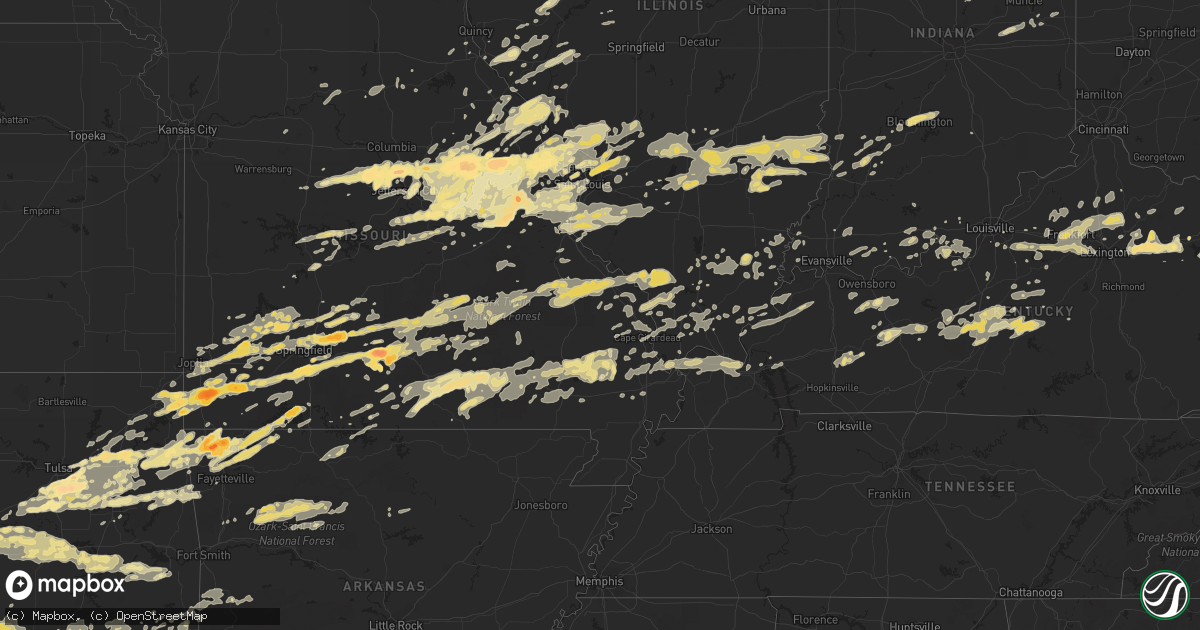
Hail Map in Illinois on April 22, 2011
Get this storm
April 22 map
$229
one time, instant access
Download today. No call, no setup
Keep the $229
Bought the map and want the full workflow? Apply the entire $229 to a subscription within 7 days. None of it is wasted.
Every map, not just this one
This buys you this map. Subscription and you get every map we run, in the markets you choose from a few cities to whole states to nationwide. Plus real-time alerts the moment a storm fires.
Contact data
Name, contact info, occupancy, even credit band for addresses in the footprint. You go from where it hit to who to call.
Become the source they trust
Unlimited branding weather history reports on demand. You already have the documented answer ready for the property owner, and you are the one who showed up with it.
Property data and RoofTrace estimates
Pull up any address you have got, its value and the exact code rules for that jurisdiction, straight from One Click Code. Then RoofTrace estimates the squares, pitch, and roof value, priced the way you price.
Storm reports in Illinois
Illinois
| Date | Description |
|---|---|
| 04/22/20114:15 PM CDT | A local report indicates 1.00 inch wind near NIOTA |
| 04/22/20111:40 PM CDT | A local report indicates 1.00 inch wind near 1 N LAWRENCEVILLE |
| 04/22/20111:39 PM CDT | Delayed report via cocorahs |
| 04/22/20111:30 PM CDT | A local report indicates 60 MPH wind near CLAY CITY |
| 04/22/20111:30 PM CDT | A local report indicates 1.75 inch wind near CLAY CITY |
| 04/22/20111:27 PM CDT | A local report indicates 1.00 inch wind near 10 W BIRDS |
| 04/22/20111:10 PM CDT | Nickel to quarter sized hail. |
| 04/22/20111:10 PM CDT | A local report indicates 1.00 inch wind near NEWTON |
| 04/22/20111:05 PM CDT | *** 1 inj *** 4 camping trailers blown over at kuhls campground...tree fell on one camper and cut it in half. Corrected location. |
| 04/22/20111:05 PM CDT | Camping trailer blown over...at kuhls campground. |
| 04/22/20111:05 PM CDT | A local report indicates 1.00 inch wind near 1 N LAWRENCEVILLE |
| 04/22/20111:05 PM CDT | One foot wide tree...over road...ingaham road and one and one half miles east of detrich blacktop. |
| 04/22/201111:22 AM CDT | A local report indicates 1.00 inch wind near LITCHFIELD |
| 04/22/201111:15 AM CDT | Hail observed at siu |
| 04/22/201111:15 AM CDT | Quarter size and slightly larger |
| 04/22/201111:11 AM CDT | A local report indicates 1.00 inch wind near 1 E GRANITE CITY |
| 04/22/20118:58 AM CDT | A local report indicates 1.00 inch wind near BEVERLY |
| 04/22/20118:55 AM CDT | A local report indicates 1.00 inch wind near CHAPIN |
| 04/21/201110:24 PM CDT | Tree fell on a house at intersection of illinois and columbus |
| 04/21/201110:01 PM CDT | A local report indicates 60 MPH wind near METROPOLIS |
| 04/21/20119:56 PM CDT | A local report indicates 76 MPH wind near ROUND KNOB |
| 04/21/20119:41 PM CDT | Tree limbs down at bern street off of maryville road...one tree fell on house |
| 04/21/20119:22 PM CDT | Tree damage throughout area. |
| 04/21/20119:21 PM CDT | Power outages and street flooding |
| 04/21/20119:20 PM CDT | Tree damage...apparently caused by tornado. Time estimated by radar. |
| 04/21/20119:17 PM CDT | Damage to a machine shed...roof uplifted...farm buildings damaged and also trees uprooted |
| 04/21/20119:15 PM CDT | Trees down and siding off homes on bond road |
| 04/21/20119:11 PM CDT | Corragated metal removed from building...small tree limbs also snapped off trees. |
| 04/21/20119:05 PM CDT | Trees snapped and uprooted...barns and silos demolished...along the north and south sides of st. Rose road for several miles. Time estimated from radar |
| 04/21/20119:05 PM CDT | Tree...shed...and home damage scattered for several miles through the st rose area. Time estimated from radar. |
| 04/21/20119:00 PM CDT | 2 and 4 inch limbs blown down |
| 04/21/20118:50 PM CDT | Trees down |
| 04/21/20118:35 PM CDT | Trailer flipped in field used as billboard at first exit n on 255 and 270 |
| 04/21/20118:30 PM CDT | Roof damage to one home along with numerous tree damage at highway 203 and mayville road |
| 04/21/20118:18 PM CDT | Quarter hail in downtown canton. |
| 04/21/20118:16 PM CDT | Hail lasted two minutes at lynn and 5th street in canton. |
All States Impacted by Hail Map on April 22, 2011
Cities Impacted by Hail Map on April 22, 2011
- Ozone, AR
- Hagarville, AR
- Saint Paul, AR
- Ozark, AR
- Pettigrew, AR
- Combs, AR
- Oark, AR
- Deer, AR
- Mount Judea, AR
- Thornfield, MO
- Bridgeport, IL
- Lawrenceville, IL
- Flat Rock, IL
- Oblong, IL
- Robinson, IL
- Sumner, IL
- Claremont, IL
- Sandoval, IL
- Odin, IL
- Bristow, OK
- Linn, MO
- Morrison, MO
- Chamois, MO
- South Greenfield, MO
- Versailles, IL
- Springfield, KY
- Elkland, MO
- Buffalo, MO
- Fair Grove, MO
- Lampe, MO
- Muse, OK
- Noble, OK
- Wanette, OK
- Macomb, OK
- Lexington, OK
- Tecumseh, OK
- Shawnee, OK
- Norman, OK
- Mcloud, OK
- Maud, OK
- Newalla, OK
- Purcell, OK
- Wayne, OK
- Vinita, OK
- Shipman, IL
- Strafford, MO
- Marshfield, MO
- Barry, IL
- Baylis, IL
- Redbird, OK
- Coweta, OK
- Porter, OK
- Mounds, OK
- Bixby, OK
- Tulsa, OK
- Jenks, OK
- Broken Arrow, OK
- Glenpool, OK
- Sapulpa, OK
- Wright City, MO
- Truesdale, MO
- Warrenton, MO
- Marionville, MO
- Mountain Grove, MO
- Mansfield, MO
- Norwood, MO
- Drury, MO
- Macomb, MO
- Annada, MO
- Elsberry, MO
- Inola, OK
- Jamestown, MO
- California, MO
- Elnora, IN
- Plainville, IN
- Washington, IN
- Alton, MO
- Birch Tree, MO
- Miller, MO
- Sarcoxie, MO
- Stotts City, MO
- Joplin, MO
- La Russell, MO
- Carthage, MO
- Reeds, MO
- Lockwood, MO
- Diamond, MO
- Mount Vernon, MO
- Sulphur Springs, AR
- Gravette, AR
- Olney, IL
- Walnut Grove, MO
- Louisiana, MO
- Eufaula, OK
- Sullivan, MO
- Saint Clair, MO
- Rogers, AR
- Centerton, AR
- Bentonville, AR
- Decatur, AR
- Hiwasse, AR
- Fitzhugh, OK
- Bradley, OK
- Foster, OK
- Byars, OK
- Ada, OK
- Pauls Valley, OK
- Asher, OK
- Stonewall, OK
- Tupelo, OK
- Centrahoma, OK
- Maysville, OK
- Elmore City, OK
- Allen, OK
- Paoli, OK
- Lindsay, OK
- Wynnewood, OK
- Stratford, OK
- Roff, OK
- Rush Springs, OK
- Marlow, OK
- Hull, IL
- Smithland, KY
- Golconda, IL
- Greenfield, MO
- Fieldon, IL
- Terral, OK
- Petrolia, TX
- Wichita Falls, TX
- Ryan, OK
- Henrietta, TX
- Kingdom City, MO
- Auxvasse, MO
- Fulton, MO
- Edwardsport, IN
- Odon, IN
- Newberry, IN
- Bicknell, IN
- Altenburg, MO
- Jackson, MO
- Wolf Lake, IL
- Makanda, IL
- Carbondale, IL
- Alto Pass, IL
- Grand Tower, IL
- Pomona, IL
- Murphysboro, IL
- Cobden, IL
- Kinderhook, IL
- Summersville, KY
- Magnolia, KY
- Buffalo, KY
- Campbellsville, KY
- Mount Sherman, KY
- Greensburg, KY
- Ava, MO
- Wyandotte, OK
- Success, MO
- Huggins, MO
- Bucyrus, MO
- Plato, MO
- Marion, IL
- Shelbina, MO
- Thebes, IL
- Benton, MO
- Scott City, MO
- Chaffee, MO
- Exeter, MO
- Cassville, MO
- Hartford, KY
- Utica, KY
- Philpot, KY
- Whitesville, KY
- Eminence, MO
- Freeburg, MO
- Prague, OK
- Salem, IL
- Saint Peter, IL
- Farina, IL
- Kinmundy, IL
- Grandin, MO
- Monett, MO
- Granby, MO
- Pierce City, MO
- Stark City, MO
- Neosho, MO
- Stella, MO
- Goodman, MO
- Seneca, MO
- Purdy, MO
- Winchester, IL
- Bluffs, IL
- Bloomfield, MO
- Advance, MO
- Dunkirk, IN
- Montpelier, IN
- Portland, IN
- Pennville, IN
- Hartford City, IN
- New Canton, IL
- Upland, IN
- Rockford, OH
- Matthews, IN
- Frankton, IN
- Celina, OH
- Elwood, IN
- Geneva, IN
- Gaston, IN
- Summitville, IN
- Spencerville, OH
- Muncie, IN
- Mendon, OH
- Alexandria, IN
- Bryant, IN
- Fairmount, IN
- Wentworth, MO
- Wagoner, OK
- Jacksonville, IL
- Chapin, IL
- Pittsfield, IL
- Springdale, AR
- Kiefer, OK
- Muskogee, OK
- Hulbert, OK
- Fort Gibson, OK
- Lawton, OK
- Essex, MO
- Clarkson, KY
- Leitchfield, KY
- Everton, MO
- Niangua, MO
- Seymour, MO
- Rogersville, MO
- Springfield, MO
- Bokoshe, OK
- Sadieville, KY
- Midway, KY
- Stamping Ground, KY
- Georgetown, KY
- Frankfort, KY
- Raywick, KY
- Marion, KY
- Mauckport, IN
- Payneville, KY
- Battletown, KY
- Brandenburg, KY
- Eolia, MO
- Hamburg, IL
- Silex, MO
- Batchtown, IL
- Kampsville, IL
- Clarksville, MO
- Noble, IL
- Peotone, IL
- Paris, MO
- Saint Louis, MO
- Tebbetts, MO
- Jefferson City, MO
- Holts Summit, MO
- Corydon, IN
- Carterville, MO
- Webb City, MO
- Oronogo, MO
- Hardyville, KY
- Bee Spring, KY
- Bradfordsville, KY
- Munfordville, KY
- Bonnieville, KY
- Mammoth Cave, KY
- Canmer, KY
- Cub Run, KY
- Upton, KY
- Lebanon, KY
- Sonora, KY
- Horse Cave, KY
- New Haven, KY
- Hodgenville, KY
- Bowling Green, MO
- Middletown, MO
- Belgrade, MO
- Potosi, MO
- Anderson, MO
- Shirley, IN
- New Castle, IN
- Hartville, MO
- Grove, OK
- Tiff City, MO
- Beggs, OK
- Patoka, IL
- Carlyle, IL
- Alma, IL
- Cynthiana, KY
- Paris, KY
- Marshall, AR
- Stilwell, OK
- Westville, OK
- Colcord, OK
- Jay, OK
- Kansas, OK
- Belle, MO
- Walters, OK
- Iberia, MO
- Ulman, MO
- Vienna, MO
- Brinktown, MO
- Brumley, MO
- Dixon, MO
- Meta, MO
- Bland, MO
- Portage Des Sioux, MO
- Saint Charles, MO
- Marion, IN
- Poplar Bluff, MO
- Henryetta, OK
- Boley, OK
- Checotah, OK
- Porum, OK
- Stroud, OK
- Castle, OK
- Weleetka, OK
- Mccurtain, OK
- Sparks, OK
- Wetumka, OK
- Paden, OK
- Whitefield, OK
- Stigler, OK
- Kinta, OK
- Keota, OK
- Okemah, OK
- Okmulgee, OK
- Meeker, OK
- Edwards, MO
- Stover, MO
- Graff, MO
- Licking, MO
- Salem, MO
- Ash Grove, MO
- Bois D Arc, MO
- Halltown, MO
- Isabella, MO
- Rushville, IL
- Cave Springs, AR
- Gentry, AR
- Garfield, AR
- Bella Vista, AR
- Reeds Spring, MO
- Kimberling City, MO
- Branson, MO
- Shell Knob, MO
- Oakland City, IN
- Lynnville, IN
- West Frankfort, IL
- Benton, IL
- Sharpsburg, KY
- Carlisle, KY
- Mount Sterling, KY
- Grovespring, MO
- Haskell, OK
- Newton, IL
- Oaktown, IN
- Bruceville, IN
- Vincennes, IN
- Cuba, MO
- Henley, MO
- Saint Elizabeth, MO
- Poseyville, IN
- Wadesville, IN
- Mascoutah, IL
- Marissa, IL
- Locust Grove, OK
- Unionville, IN
- Nashville, IN
- Bloomington, IN
- Bristow, IN
- Branchville, IN
- Saint Croix, IN
- Berryville, AR
- Eureka Springs, AR
- Xenia, IL
- Lebanon, MO
- Phillipsburg, MO
- New Bloomfield, MO
- Mokane, MO
- Rhineland, MO
- Montgomery City, MO
- Hermann, MO
- New Florence, MO
- Jonesburg, MO
- Portland, MO
- Preston, MO
- Urbana, MO
- Pleasant Hope, MO
- Villa Ridge, MO
- Fenton, MO
- Leslie, MO
- Marthasville, MO
- New Haven, MO
- Rosebud, MO
- Wildwood, MO
- Augusta, MO
- Union, MO
- Arnold, MO
- Washington, MO
- Gray Summit, MO
- Beaufort, MO
- High Ridge, MO
- Owensville, MO
- Robertsville, MO
- Eureka, MO
- Gerald, MO
- Labadie, MO
- Pacific, MO
- Berger, MO
- Catawissa, MO
- House Springs, MO
- Imperial, MO
- Clarksburg, MO
- Chrisney, IN
- Gentryville, IN
- Prairie Home, MO
- Ashland, MO
- Centertown, MO
- Hartsburg, MO
- Fredericktown, MO
- Sainte Genevieve, MO
- Farmington, MO
- Perryville, MO
- Saint Mary, MO
- Wentzville, MO
- Foristell, MO
- Steedman, MO
- Williamsburg, MO
- Mount Sterling, MO
- High Hill, MO
- Chaplin, KY
- Lawrenceburg, KY
- Willisburg, KY
- Creal Springs, IL
- Ozark, IL
- New Burnside, IL
- Owingsville, KY
- Heavener, OK
- Waldron, AR
- Oakford, IL
- Charleston, MO
- Loveland, OK
- Grandfield, OK
- Devol, OK
- Geronimo, OK
- Cannelton, IN
- Derby, IN
- Morrisville, MO
- Aldrich, MO
- Wappapello, MO
- Greenville, MO
- Puxico, MO
- Gipsy, MO
- Zalma, MO
- McGee, MO
- Lake Saint Louis, MO
- O'Fallon, MO
- Saint Peters, MO
- Guyton, GA
- Mooreland, IN
- Madison, MO
- Whitewater, MO
- Marble Hill, MO
- Burfordville, MO
- Conway, MO
- Belleview, MO
- Duncan, OK
- Clinton, AR
- Mountainburg, AR
- Arcadia, IN
- Golden City, MO
- Siloam Springs, AR
- Catoosa, OK
- Claremore, OK
- Cairo, IL
- Bridgeton, MO
- Maryland Heights, MO
- Florissant, MO
- Warsaw, MO
- Wellington, KY
- Morehead, KY
- West Liberty, KY
- Rockwood, IL
- Ava, IL
- McLean, IL
- Bismarck, MO
- Park Hills, MO
- Doe Run, MO
- Ironton, MO
- Ellsinore, MO
- Fort Branch, IN
- Lonedell, MO
- Waterloo, IL
- Valmeyer, IL
- Winona, MO
- Mount Eden, KY
- Fisherville, KY
- Shelbyville, KY
- Finchville, KY
- Waddy, KY
- Taylorsville, KY
- Lexington, KY
- Versailles, KY
- Louisville, KY
- Frohna, MO
- Uniontown, MO
- Anna, IL
- Buncombe, IL
- Bunker Hill, IL
- Alton, IL
- Godfrey, IL
- Brighton, IL
- Honobia, OK
- Energy, IL
- Watson, OK
- Sturdivant, MO
- Brownwood, MO
- Central, IN
- Elizabeth, IN
- Laconia, IN
- Lenox, MO
- Houston, MO
- Eldred, IL
- Vandalia, IL
- Smithboro, IL
- Mulberry Grove, IL
- Carmi, IL
- Otterville, MO
- Smithton, MO
- Bonnots Mill, MO
- Rose, OK
- Twin Oaks, OK
- Westphalia, MO
- Koeltztown, MO
- Yorktown, IN
- Troy, MO
- Clay City, IL
- Olive Hill, KY
- Grayson, KY
- Fults, IL
- Festus, MO
- Comanche, OK
- Temple, OK
- Hastings, OK
- Waurika, OK
- Ozark, MO
- Nixa, MO
- Tahlequah, OK
- Hopkinsville, KY
- White Plains, KY
- Greenville, KY
- Crofton, KY
- Tuskahoma, OK
- Talihina, OK
- Roach, MO
- Camdenton, MO
- Brussels, IL
- Fortuna, MO
- New Harmony, IN
- Nebo, IL
- Pittsburg, OK
- Broughton, IL
- Pryor, OK
- Edwardsville, IL
- Winchester, IN
- Lynn, IN
- Modoc, IN
- Hartford, IL
- East Alton, IL
- South Roxana, IL
- Ledbetter, KY
- Brookport, IL
- Paducah, KY
- Dover, AR
- West Plains, MO
- Peace Valley, MO
- Leopold, IN
- Tell City, IN
- Matthews, MO
- Sasakwa, OK
- Holdenville, OK
- Mount Erie, IL
- Norris City, IL
- Enfield, IL
- Berry, KY
- Corinth, KY
- Sedgewickville, MO
- Wilkinson, IN
- Markleville, IN
- Eagle Rock, MO
- Aurora, MO
- Verona, MO
- Griggsville, IL
- Farmington, AR
- Blanco, OK
- Hartshorne, OK
- Mount Sterling, IL
- Frankford, MO
- McClure, IL
- Dongola, IL
- Jonesboro, IL
- Cape Girardeau, MO
- Yellville, AR
- Oakland, AR
- Peel, AR
- Pontiac, MO
- Salt Lick, KY
- Lowell, AR
- Watts, OK
- Maysville, AR
- Lincoln, AR
- Hindsville, AR
- Proctor, OK
- Peggs, OK
- Chouteau, OK
- Golden, MO
- Welling, OK
- Fayetteville, AR
- Kellyville, OK
- Spavinaw, OK
- Pineville, MO
- Oaks, OK
- Pea Ridge, AR
- Salina, OK
- Summers, AR
- Canehill, AR
- Cromwell, KY
- Beaver Dam, KY
- Grantsburg, IL
- Glendale, KY
- Gorham, IL
- Vergennes, IL
- Climax Springs, MO
- Hardin, IL
- Pelsor, AR
- Mulkeytown, IL
- Royalton, IL
- Zeigler, IL
- Pevely, MO
- Barnhart, MO
- Witts Springs, AR
- Coxs Creek, KY
- Payson, IL
- Liberty, IL
- Vandalia, MO
- Black, MO
- Chesterfield, MO
- Hodgen, OK
- Monee, IL
- Montgomery, IN
- New Salisbury, IN
- Springfield, GA
- Greenville, IL
- Mountain View, MO
- Pomona, MO
- Pottersville, MO
- English, IN
- French Lick, IN
- Daisy, OK
- Stringtown, OK
- Crossville, IL
- Macks Creek, MO
- Rosiclare, IL
- Leavenworth, IN
- Macedonia, IL
- McLeansboro, IL
- Logan, IL
- Galatia, IL
- Thompsonville, IL
- Alhambra, IL
- Barlow, KY
- La Center, KY
- Kevil, KY
- Highlandville, MO
- Cabool, MO
- Fordland, MO
- Miami, OK
- Crane, MO
- Vanzant, MO
- Billings, MO
- Clever, MO
- Fairland, OK
- Fairview, MO
- Sparta, MO
- Breese, IL
- Theodosia, MO
- Noble, MO
- Noel, MO
- Winchester, KY
- Leslie, AR
- Fox, AR
- Defiance, MO
- Ellington, MO
- Redford, MO
- West Liberty, IL
- Sainte Marie, IL
- Willow Hill, IL
- Louisville, IL
- Dieterich, IL
- Stoy, IL
- Dundas, IL
- Palestine, IL
- Iuka, IL
- Ingraham, IL
- Brownstown, IL
- Edgewood, IL
- Mason, IL
- Wheeler, IL
- Shobonier, IL
- Morgantown, KY
- Caneyville, KY
- Morganfield, KY
- Sturgis, KY
- Bloomfield, IN
- Clayton, IL
- Falcon, MO
- Marine, IL
- Bloomfield, KY
- Astoria, IL
- Vermont, IL
- Lowndes, MO
- Glen Carbon, IL
- Solo, MO
- Caledonia, MO
- Willard, MO
- Campbell Hill, IL
- Duenweg, MO
- Lesterville, MO
- Lamar, MO
- Yukon, MO
- Jasper, MO
- Jacob, IL
- Edgar Springs, MO
- De Soto, IL
- Bolivar, MO
- Elk Creek, MO
- Summersville, MO
- Eunice, MO
- Brighton, MO
- Afton, OK
- Jadwin, MO
- Bunker, MO
- Boss, MO
- Long Lane, MO
- Raymondville, MO
- Beulah, MO
- Bruner, MO
- Hartshorn, MO
- Bixby, MO
- Elkville, IL
- Dadeville, MO
- Centerville, MO
- Nashoba, OK
- Clayton, OK
- Jeffersonville, KY
- Syracuse, MO
- West Alton, MO
- Argyle, MO
- Dorsey, IL
- Jerseyville, IL
- Bethalto, IL
- Tipton, MO
- Piasa, IL
- Golden Eagle, IL
- Grafton, IL
- Loose Creek, MO
- Hazelwood, MO
- Florence, MO
- Fidelity, IL
- Bunceton, MO
- Dow, IL
- Elsah, IL
- Atlanta, IN
- Sulphur, OK
- Davis, OK
- Harrison, AR
- Evanston, IN
- Steelville, MO
- Cedar Hill, MO
- Columbia, MO
- Earth City, MO
- Saint Thomas, MO
- Moscow Mills, MO
- Saint Ann, MO
- Ballwin, MO
- Valley Park, MO
- White Hall, IL
- Hillview, IL
- Roodhouse, IL
- Mansfield, AR
- Mena, AR
- Huntington, AR
- Hartford, AR
- Booneville, AR
- Smithville, OK
- Granite City, IL
- Morocco, IN
- Albion, OK
- Rockport, KY
- Rueter, MO
- Carrollton, IL
- Huntsville, MO
- Moberly, MO
- Cairo, MO
- Fremont, MO
- Van Buren, MO
- Olympia, KY
- Columbus, IN
- Center, MO
- Bourbon, MO
- Frederick, OK
- Byers, TX
- Willow Springs, MO
- Caulfield, MO
- Gravois Mills, MO
- Winfield, MO
- Foley, MO
- Flemington, MO
- Sulphur, IN
- Cross Timbers, MO
- Big Cabin, OK
- Roxana, IL
- Moro, IL
- Worden, IL
- Wood River, IL
- Middletown, IN
- Vichy, MO
- Mcalester, OK
- Wilburton, OK
- Kiowa, OK
- Concord, IL
- Meredosia, IL
- Glasford, IL
- Cuba, IL
- Canton, IL
- Lewistown, IL
- Villa Ridge, IL
- Ramsey, IL
- Shepherdsville, KY
- Kuttawa, KY
- Princeton, KY
- Eddyville, KY
- Sikeston, MO
- Bell City, MO
- Oran, MO
- Vanduser, MO
- Camden, IL
- Littleton, IL
- Collinsville, IL
- Lebanon, IL
- Troy, IL
- Saint Jacob, IL
- Eldon, MO
- Lake Ozark, MO
- Hermitage, MO
- Staunton, IL
- Randlett, OK
- Chattanooga, OK
- Hillsboro, MO
- Millstadt, IL
- Crystal City, MO
- Addieville, IL
- Saint Libory, IL
- New Athens, IL
- Freeburg, IL
- New Baden, IL
- Lenzburg, IL
- Columbia, IL
- Hecker, IL
- Belleville, IL
- Smithton, IL
- Herculaneum, MO
- Okawville, IL
- Red Bud, IL
- Eddyville, IL
- Stonefort, IL
- Mill Spring, MO
- Williamsville, MO
- Losantville, IN
- Hagerstown, IN
- Sedalia, MO
- Park Hill, OK
- Clay, KY
- Salem, KY
- Dixon, KY
- New Haven, IL
- Shawneetown, IL
- Flemingsburg, KY
- Salisbury, MO
- Dalton, MO
- Slater, MO
- Keytesville, MO
- Calvert City, KY
- Kouts, IN
- La Crosse, IN
- Fort Wayne, IN
- Falmouth, KY
- Tishomingo, OK
- Elizabethtown, KY
- Lebanon Junction, KY
- West Point, KY
- Wister, OK
- Antlers, OK
- Solsberry, IN
- Altamont, IL
- Beecher City, IL
- Saint Elmo, IL
- Hennepin, OK
- Rinard, IL
- Broken Bow, OK
- Dora, MO
- Demotte, IN
- Strang, OK
- Adair, OK
- Calhoun, IL
- Sailor Springs, IL
- Merom, IN
- Fillmore, IL
- Centralia, IL
- Donnellson, IL
- Pocahontas, IL
- Vernon, IL
- Coffeen, IL
- Big Clifty, KY
- White Mills, KY
- Cecilia, KY
- Eastview, KY
- Ridgeland, SC
- Tillman, SC
- Loretto, KY
- Statesboro, GA
- Wasola, MO
- Brixey, MO
- Venice, IL
- Zanoni, MO
- Seminole, OK
- Eldorado, IL
- Calhoun, KY
- Gainesville, MO
- Caseyville, IL
- Fairview Heights, IL
- O'Fallon, IL
- Bellflower, MO
- Truxton, MO
- Timewell, IL
- Hoyleton, IL
- Lead Hill, AR
- Quapaw, OK
- Livermore, KY
- Rumsey, KY
- Fordsville, KY
- Boonville, IN
- Tennyson, IN
- Elizabethtown, IL
- Cedarcreek, MO
- Humansville, MO
- Goreville, IL
- Holland, MI
- Bagdad, KY
- Bardstown, KY
- Germantown, IL
- Bartelso, IL
- Clarksville, AR
- Hawk Point, MO
- Old Monroe, MO
- Medora, IL
- Galena, MO
- Cape Fair, MO
- Horse Branch, KY
- West Paducah, KY
- Wickliffe, KY
- Mounds, IL
- Metropolis, IL
- Miller City, IL
- Mound City, IL
- Symsonia, KY
- Depew, OK
- Ashland, IL
- Tallula, IL
- Petersburg, IL
- Birdseye, IN
- Bethel, OK
- Piedmont, MO
- Thayer, MO
- Doniphan, MO
- Koshkonong, MO
- Oak Grove, AR
- Wallingford, KY
- Mountain View, AR
- Depauw, IN
- Cypress, IL
- Owensboro, KY
- Fittstown, OK
- Fletcher, OK
- Konawa, OK
- Mill Creek, OK
- Coalgate, OK
- Faxon, OK
- Litchfield, IL
- De Soto, MO
- Blue Eye, MO
- Ridgedale, MO
- Hollister, MO
- Gillespie, IL
- Green Ridge, MO
- Highland, IL
- Lyons, IN
- Sandborn, IN
- Hillsboro, KY
- Keystone, IN
- Palmyra, MO
- Monroe City, MO
- Rolla, MO
- Brooklet, GA
- Bellflower, IL
- Chambersburg, IL
- Saint James, MO
- Johnston City, IL
- Friedheim, MO
- Oak Ridge, MO
- Simpson, IL
- Vienna, IL
- Martinsburg, MO
- Hustonville, KY
- Ullin, IL
- Elkins, AR
- Winslow, AR
- Harviell, MO
- Pleasant Hill, IL
- Sorento, IL
- Walshville, IL
- Omaha, IL
- Ridgway, IL
- Patton, MO
- Grand Rivers, KY
- Broseley, MO
- Fisk, MO
- Owenton, KY
- Centertown, KY
- Lamar, IN
- Plainville, IL
- Buchanan, MI
- Berrien Springs, MI
- Niles, MI
- Galien, MI
- Switz City, IN
- Sylvania, GA
- Newington, GA
- Hannibal, MO
- Flora, IL
- Palmyra, IN
- Wardville, OK
- Herod, IL
- Cave In Rock, IL
- Sunrise Beach, MO
- Rocky Mount, MO
- Saint Catharine, KY
- New Hope, KY
- Santa Claus, IN
- Ekron, KY
- Washburn, MO
- Millersville, MO
- Protem, MO
- Perrysburg, OH
- Luckey, OH
- Sullivan, IN
- Carlisle, IN
- Hanna, OK
- Wewoka, OK
- Earlsboro, OK
- Quinton, OK
- Brunswick, MO
- Valles Mines, MO
- French Village, MO
- Bonne Terre, MO
- Mount Vernon, IN
- Graytown, OH
- Elmore, OH
- Pleasureville, KY
- Lockport, KY
- Bethlehem, KY
- Linton, IN
- Blackburn, MO
- Alma, MO
- Ewing, KY
- Wheatfield, IN
- Eugene, MO
- Wilsonville, IL
- Livingston, IL
- Benld, IL
- Wellsville, MO
- Dittmer, MO
- Lovejoy, IL
- East Saint Louis, IL
- Lohman, MO
- New Douglas, IL
- Mount Olive, IL
- East Carondelet, IL
- Cottage Hills, IL
- Russellville, MO
- Nashville, IL
- Kane, IL
- Chelsea, OK
- Rockport, IL
- Arrowsmith, IL
- Simpsonville, KY
- Eucha, OK
- Chester, AR
- Frenchburg, KY


