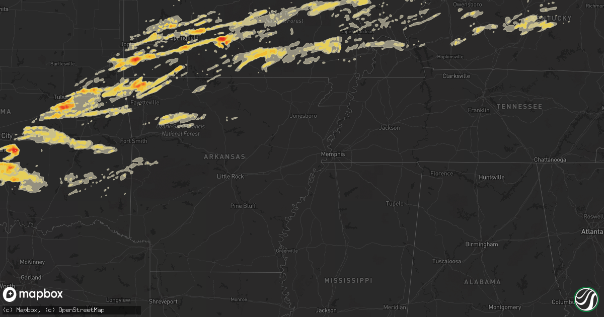
Hail Map on April 22, 2011
Get this storm
April 22 map
$229
one time, instant access
Download today. No call, no setup
Keep the $229
Bought the map and want the full workflow? Apply the entire $229 to a subscription within 7 days. None of it is wasted.
Every map, not just this one
This buys you this map. Subscription and you get every map we run, in the markets you choose from a few cities to whole states to nationwide. Plus real-time alerts the moment a storm fires.
Contact data
Name, contact info, occupancy, even credit band for addresses in the footprint. You go from where it hit to who to call.
Become the source they trust
Unlimited branding weather history reports on demand. You already have the documented answer ready for the property owner, and you are the one who showed up with it.
Property data and RoofTrace estimates
Pull up any address you have got, its value and the exact code rules for that jurisdiction, straight from One Click Code. Then RoofTrace estimates the squares, pitch, and roof value, priced the way you price.
States Impacted by Hail Map on April 22, 2011
Storm reports
Kentucky
| Date | Description |
|---|---|
| 04/22/20116:23 PM CDT | Lex18 reports damage and a window blown out on romany road in the chevy chase area |
| 04/22/20116:13 PM CDT | An nws storm survey confirmed that an ef-0 tornado with estimated winds of 65 mph touched down 4 miles east of versailles. The 40 yard wide tornado was on the ground fo |
| 04/22/20116:12 PM CDT | Lex18 reports damage to trees and fences on marcellus drive |
| 04/22/20116:07 PM CDT | An nws storm survey confirmed an ef-0 tornado touched down 1 mile southeast of versailles in woodford county. The 60 yard wide tornado touched down at 707 pm edt causin |
| 04/22/20115:23 PM CDT | A local report indicates 1.00 inch wind near 8 S SHELBYVILLE |
| 04/22/20116:45 AM CDT | A few trees down |
| 04/22/20116:35 AM CDT | Multiple trees reported down around the city of ashland |
| 04/22/20116:30 AM CDT | Multiple trees and powerlines down throughout greenup county |
| 04/22/20116:25 AM CDT | Large branches broken. |
| 04/22/20115:50 AM CDT | One tree was reported down. |
| 04/22/20115:48 AM CDT | One tree down on park lake road |
| 04/22/20115:19 AM CDT | A local report indicates 1.00 inch wind near 5 S CYNTHIANA |
| 04/22/20115:09 AM CDT | An nws storm survey confirmed an ef-0 tornado with winds of 85 mph touched down about 1.5 miles east of connersville and remained on the ground for a quarter to half a |
| 04/22/20115:00 AM CDT | Hwy 525 south. |
| 04/22/20114:39 AM CDT | A local report indicates 1.00 inch wind near FRANKFORT |
| 04/22/20111:15 AM CDT | Trained spotter reports 1 to 1.5 inch hail |
| 04/22/201112:07 AM CDT | Tree down on us 31w |
| 04/21/201111:32 PM CDT | Tree down on ky 228 |
| 04/21/201111:27 PM CDT | Power lines down |
| 04/21/201111:07 PM CDT | Just north of webster-henderson county line on north end of poole. Multiple houses damaged and at least 1 with roof off. Numerous trees and powerlines down. |
| 04/21/20119:45 PM CDT | Partial roof and siding off residence. Also...window out of car |
| 04/21/20117:45 PM CDT | A local report indicates 1.75 inch wind near SALT LICK |
| 04/21/20117:37 PM CDT | Quarter size hail was reported on hwy 36 just south of owingsville. |
| 04/21/20117:13 PM CDT | A local report indicates 1.75 inch wind near 1 WSW SIDEVIEW |
| 04/21/20117:08 PM CDT | Golf ball sized hail reported on the border between clark... Bourbon... And montgomery counties. |
Georgia
| Date | Description |
|---|---|
| 04/22/20115:05 PM CDT | A local report indicates 1.00 inch wind near 4 E EDEN |
| 04/22/20114:31 PM CDT | Quarter size hail was reported on courthouse road near midland road. |
| 04/22/20114:25 PM CDT | Powerlines down along n ash st. |
Illinois
| Date | Description |
|---|---|
| 04/22/20114:15 PM CDT | A local report indicates 1.00 inch wind near NIOTA |
| 04/22/20111:40 PM CDT | A local report indicates 1.00 inch wind near 1 N LAWRENCEVILLE |
| 04/22/20111:39 PM CDT | Delayed report via cocorahs |
| 04/22/20111:30 PM CDT | A local report indicates 60 MPH wind near CLAY CITY |
| 04/22/20111:30 PM CDT | A local report indicates 1.75 inch wind near CLAY CITY |
| 04/22/20111:27 PM CDT | A local report indicates 1.00 inch wind near 10 W BIRDS |
| 04/22/20111:10 PM CDT | A local report indicates 1.00 inch wind near NEWTON |
| 04/22/20111:10 PM CDT | Nickel to quarter sized hail. |
| 04/22/20111:05 PM CDT | One foot wide tree...over road...ingaham road and one and one half miles east of detrich blacktop. |
| 04/22/20111:05 PM CDT | A local report indicates 1.00 inch wind near 1 N LAWRENCEVILLE |
| 04/22/20111:05 PM CDT | Camping trailer blown over...at kuhls campground. |
| 04/22/20111:05 PM CDT | *** 1 inj *** 4 camping trailers blown over at kuhls campground...tree fell on one camper and cut it in half. Corrected location. |
| 04/22/201111:22 AM CDT | A local report indicates 1.00 inch wind near LITCHFIELD |
| 04/22/201111:15 AM CDT | Hail observed at siu |
| 04/22/201111:15 AM CDT | Quarter size and slightly larger |
| 04/22/201111:11 AM CDT | A local report indicates 1.00 inch wind near 1 E GRANITE CITY |
| 04/22/20118:58 AM CDT | A local report indicates 1.00 inch wind near BEVERLY |
| 04/22/20118:55 AM CDT | A local report indicates 1.00 inch wind near CHAPIN |
| 04/21/201110:24 PM CDT | Tree fell on a house at intersection of illinois and columbus |
| 04/21/201110:01 PM CDT | A local report indicates 60 MPH wind near METROPOLIS |
| 04/21/20119:56 PM CDT | A local report indicates 76 MPH wind near ROUND KNOB |
| 04/21/20119:41 PM CDT | Tree limbs down at bern street off of maryville road...one tree fell on house |
| 04/21/20119:22 PM CDT | Tree damage throughout area. |
| 04/21/20119:21 PM CDT | Power outages and street flooding |
| 04/21/20119:20 PM CDT | Tree damage...apparently caused by tornado. Time estimated by radar. |
| 04/21/20119:17 PM CDT | Damage to a machine shed...roof uplifted...farm buildings damaged and also trees uprooted |
| 04/21/20119:15 PM CDT | Trees down and siding off homes on bond road |
| 04/21/20119:11 PM CDT | Corragated metal removed from building...small tree limbs also snapped off trees. |
| 04/21/20119:05 PM CDT | Trees snapped and uprooted...barns and silos demolished...along the north and south sides of st. Rose road for several miles. Time estimated from radar |
| 04/21/20119:05 PM CDT | Tree...shed...and home damage scattered for several miles through the st rose area. Time estimated from radar. |
| 04/21/20119:00 PM CDT | 2 and 4 inch limbs blown down |
| 04/21/20118:50 PM CDT | Trees down |
| 04/21/20118:35 PM CDT | Trailer flipped in field used as billboard at first exit n on 255 and 270 |
| 04/21/20118:30 PM CDT | Roof damage to one home along with numerous tree damage at highway 203 and mayville road |
| 04/21/20118:18 PM CDT | Quarter hail in downtown canton. |
| 04/21/20118:16 PM CDT | Hail lasted two minutes at lynn and 5th street in canton. |
Texas
| Date | Description |
|---|---|
| 04/22/20116:51 PM CDT | A local report indicates 1.00 inch wind near WICHITA FALLS |
| 04/22/20116:32 PM CDT | Public report of 1.25 inch hail in wichita falls. |
| 04/22/201111:42 AM CDT | Ktxs called with a report of possible tornado damage. A gooseneck trailer was thrown approx 100 yrds at the intersection of county road 433 and county road 452. |
| 04/22/201111:42 AM CDT | Ktxs called with a report of possible tornado damage. A gooseneck trailer was thrown approx 100 yrds at the intersection of county road 433 and county road 452. |
| 04/21/20117:59 PM CDT | A local report indicates 1.00 inch wind near 5 N HENRIETTA |
| 04/21/20117:40 PM CDT | A local report indicates 2.25 inch wind near 1 SW DEAN |
| 04/21/20117:30 PM CDT | A local report indicates 2.00 inch wind near 3 NE DEAN |
| 04/21/20117:26 PM CDT | A local report indicates 1.50 inch wind near 1 NE DEAN |
| 04/21/20117:13 PM CDT | A local report indicates 1.00 inch wind near 7 N JOLLY |
| 04/21/20117:10 PM CDT | Damage to sun roof of residential structure. |
Arkansas
| Date | Description |
|---|---|
| 04/22/20116:41 PM CDT | A brief tornado was reported. No damage has been reported in the area. This report is preliminary. |
| 04/22/20115:50 AM CDT | Started small then reached quarter size. |
| 04/22/20111:05 AM CDT | Lots of leaves off the trees from the hail |
| 04/22/20111:03 AM CDT | Also hailed |
| 04/22/20111:03 AM CDT | A local report indicates 1.00 inch wind near 2 SE EUREKA SPRINGS |
| 04/21/20117:21 PM CDT | A brief tornado was reported near mile marker 88 on interstate 540. No damage reports have been received in this area. This is a preliminary report. |
| 04/21/20117:15 PM CDT | A local report indicates 2.00 inch wind near 3 S BENTONVILLE |
| 04/21/20117:10 PM CDT | Large hail fell for 3 min...mostly 1.5 inch hail with largest being 2 inches |
| 04/21/20117:05 PM CDT | Brief tornado touchdown near the northwest arkansas regional airport. |
Missouri
| Date | Description |
|---|---|
| 04/22/20116:58 PM CDT | A local report indicates 2.75 inch wind near WARRENTON |
| 04/22/20116:56 PM CDT | Penny to quarter sized hail. |
| 04/22/20116:56 PM CDT | A local report indicates 1.75 inch wind near WALNUT GROVE |
| 04/22/20116:55 PM CDT | A local report indicates 1.75 inch wind near WARRENTON |
| 04/22/20116:52 PM CDT | A local report indicates 4.50 inch wind near WARRENTON |
| 04/22/20116:50 PM CDT | A local report indicates 1.75 inch wind near 3 S WARRENTON |
| 04/22/20116:50 PM CDT | A local report indicates 1.00 inch wind near JONESBURG |
| 04/22/20116:48 PM CDT | A local report indicates 1.00 inch wind near WARRENTON |
| 04/22/20116:46 PM CDT | A local report indicates 1.00 inch wind near JONESBURG |
| 04/22/20116:44 PM CDT | A local report indicates 1.25 inch wind near WARRENTON |
| 04/22/20116:42 PM CDT | A local report indicates 1.25 inch wind near NIANGUA |
| 04/22/20116:42 PM CDT | A local report indicates 1.00 inch wind near 2 SE GREENFIELD |
| 04/22/20116:40 PM CDT | A local report indicates 1.75 inch wind near MARSHFIELD |
| 04/22/20116:38 PM CDT | 3 to 4 inch hail at hermann country club golf course |
| 04/22/20116:37 PM CDT | A local report indicates 1.75 inch wind near LINN |
| 04/22/20116:37 PM CDT | A local report indicates 1.00 inch wind near MARSHFIELD |
| 04/22/20116:36 PM CDT | A local report indicates 1.00 inch wind near MARSHFIELD |
| 04/22/20116:35 PM CDT | A local report indicates 2.50 inch wind near 1 NE RHINELAND |
| 04/22/20116:35 PM CDT | A local report indicates 1.00 inch wind near MARSHFIELD |
| 04/22/20116:35 PM CDT | Numerous baseball to gragefruit size hailstones |
| 04/22/20116:35 PM CDT | Observed 6 miles north of belle |
| 04/22/20116:33 PM CDT | A local report indicates 1.00 inch wind near 5 SE LINN |
| 04/22/20116:32 PM CDT | A local report indicates 2.75 inch wind near BIG SPRING |
| 04/22/20116:30 PM CDT | A local report indicates 1.75 inch wind near 10 S LINN |
| 04/22/20116:30 PM CDT | A local report indicates 2.75 inch wind near 4 N HERMANN |
| 04/22/20116:26 PM CDT | A local report indicates 1.00 inch wind near 3 E STRAFFORD |
| 04/22/20116:26 PM CDT | A local report indicates 1.75 inch wind near 4 E STRAFFORD |
| 04/22/20116:18 PM CDT | A local report indicates 1.25 inch wind near 3 E MONETT |
| 04/22/20116:18 PM CDT | On hwy k along the callaway and montgomery county line |
| 04/22/20116:16 PM CDT | A local report indicates 1.00 inch wind near 1 W STRAFFORD |
| 04/22/20116:15 PM CDT | Measured near the intersection of hwy hh and k |
| 04/22/20116:14 PM CDT | A local report indicates 1.00 inch wind near PORTLAND |
| 04/22/20116:10 PM CDT | A local report indicates 1.75 inch wind near 4 SW MONETT |
| 04/22/20116:07 PM CDT | I44 at 79 mile marker. |
| 04/22/20116:00 PM CDT | A local report indicates 1.00 inch wind near 4 WNW VERONA |
| 04/22/20115:52 PM CDT | A local report indicates 1.00 inch wind near 4 E NEWTONIA |
| 04/22/20115:51 PM CDT | Hail observed on highway 54 |
| 04/22/20115:47 PM CDT | A local report indicates 1.50 inch wind near 3 E NEW BLOOMFIELD |
| 04/22/20115:45 PM CDT | Report from law enforement relayed through emergency management |
| 04/22/20115:44 PM CDT | Reported at corner of norway street and monarch street. |
| 04/22/20115:35 PM CDT | A local report indicates 2.00 inch wind near 2 NE HARTSBURG |
| 04/22/20115:32 PM CDT | Report from ashland pd...relayed by columbia eoc |
| 04/22/20115:31 PM CDT | Reported at intersection of county road 1087 and county road 2010. |
| 04/22/20115:21 PM CDT | Report relayed through mo troop f |
| 04/22/20115:04 PM CDT | A local report indicates 2.50 inch wind near 8 N CALIFORNIA |
| 04/22/20115:00 PM CDT | A local report indicates 2.00 inch wind near 8 N CALIFORNIA |
| 04/22/20114:45 PM CDT | Fire chief collected tennis ball hail |
| 04/22/20113:50 PM CDT | One inch hail reported in purcell. |
| 04/22/201111:45 AM CDT | A local report indicates 1.25 inch wind near 1 SW FENTON |
| 04/22/201111:40 AM CDT | 1.25 inch hail...additionally some siding blown off mobile home. Although wind estimated to be less than 60 mph. |
| 04/22/201111:40 AM CDT | 1.25 inch hail...additionally some siding blown off mobile home. Although wind estimated to be less than 60 mph. |
| 04/22/201111:32 AM CDT | Hail lasted about two minutes at 270 and tesson ferry |
| 04/22/201111:13 AM CDT | A local report indicates 1.00 inch wind near 2 E ROBERTSVILLE |
| 04/22/201111:08 AM CDT | Mainly nickel sized...a few quarter sized hail stones |
| 04/22/201111:02 AM CDT | Hail observed in the town of anaconda |
| 04/22/201110:55 AM CDT | A local report indicates 1.00 inch wind near MARYLAND HEIGHTS |
| 04/22/201110:52 AM CDT | A local report indicates 1.00 inch wind near CREVE COEUR |
| 04/22/201110:47 AM CDT | A local report indicates 1.00 inch wind near 4 NW UNION |
| 04/22/201110:39 AM CDT | A local report indicates 1.00 inch wind near NEW HAVEN |
| 04/22/201110:30 AM CDT | A local report indicates 1.00 inch wind near OWENSVILLE |
| 04/22/201110:24 AM CDT | Hail just started. Report just east of rosebud on gasconade and franklin county lines. |
| 04/22/201110:15 AM CDT | A local report indicates 1.00 inch wind near OWENSVILLE |
| 04/22/201110:11 AM CDT | A local report indicates 1.00 inch wind near PERSHING |
| 04/22/201110:10 AM CDT | A local report indicates 1.00 inch wind near OWENSVILLE |
| 04/22/20119:55 AM CDT | A local report indicates 1.25 inch wind near 8 E LINN |
| 04/22/20119:25 AM CDT | East side of jefferson city. Lasted 3 to 4 minutes. |
| 04/22/20119:25 AM CDT | Hail lasted about one minute |
| 04/22/20119:25 AM CDT | Hail lasted 2 minutes...ranged from nickel size to quarter size |
| 04/22/20119:09 AM CDT | Media relayed a report from the public |
| 04/22/20119:02 AM CDT | A local report indicates 1.00 inch wind near CENTER |
| 04/22/20119:02 AM CDT | A local report indicates 1.00 inch wind near CENTERTOWN |
| 04/22/20117:05 AM CDT | A local report indicates 1.00 inch wind near LA PLATA |
| 04/22/20114:16 AM CDT | Public reports quarter sized hail |
| 04/22/20111:55 AM CDT | A local report indicates 1.00 inch wind near 1 S BRANSON WEST |
| 04/21/201110:48 PM CDT | Public reports several docks damaged along with several boats damaged and flip over in the lake. |
| 04/21/201110:48 PM CDT | Golf ball sized hail reported on joe bald rd. |
| 04/21/201110:31 PM CDT | A local report indicates 1.00 inch wind near ROGERSVILLE |
| 04/21/201110:25 PM CDT | Hail 1.75 to 2.00 inches in diameter with trees reported down. |
| 04/21/201110:23 PM CDT | A local report indicates 1.00 inch wind near 1 S NORWOOD |
| 04/21/201110:15 PM CDT | Fire dept reports baseball sized hail in maccomb. |
| 04/21/20119:35 PM CDT | 3 to 4 inch hail at hermann country club golf coarse |
| 04/21/20119:17 PM CDT | Numerous trees down. Also power lines down in oran and chaffee |
| 04/21/20119:04 PM CDT | 50 mph winds also reported |
| 04/21/20119:00 PM CDT | A local report indicates 1.00 inch wind near GRANDIN |
| 04/21/20119:00 PM CDT | House trailer overturned and trees down in town |
| 04/21/20118:53 PM CDT | Main terminal windows blown out at lambert airport....roof off of concourse c...and power outages |
| 04/21/20118:48 PM CDT | 2 large trees down...and many 1-5 inch limbs down |
| 04/21/20118:43 PM CDT | Air national guard building damaged...and structural damage to buildings at the airport...and cars flipped |
| 04/21/20118:37 PM CDT | A local report indicates 1.00 inch wind near 5 NE SPRINGFIELD |
| 04/21/20118:34 PM CDT | Tractor trailers standing on end. |
| 04/21/20118:32 PM CDT | Power lines down at i-70 and cyprus |
| 04/21/20118:25 PM CDT | Falling west and southwest of city limits |
| 04/21/20118:21 PM CDT | Chasers report damage and debris near exit 236 on i70...trees damaged...cell phone tower bent over...flag pole at airport bent over...interstate signs down and small de |
| 04/21/20118:18 PM CDT | Large tree fell through a home at 270 |
| 04/21/20118:15 PM CDT | At least one home damaged near chambers and west florrisant |
| 04/21/20118:15 PM CDT | Roof damge and entire 2nd floor gone off a church |
| 04/21/20118:14 PM CDT | Observer at stl reports tornado at lambert field moving east |
| 04/21/20118:10 PM CDT | Semi blown over at highway 70 and st charles rock road |
| 04/21/20118:09 PM CDT | Power lines and trees down at creve coeur mill and pritchard farm roads |
| 04/21/20118:04 PM CDT | Trees and power lines down at 2 miiles west of highway 270 and dorsett road |
| 04/21/20117:59 PM CDT | Trees and power lines down at 2 miiles west of highway 270 and dorsett road |
| 04/21/20117:56 PM CDT | Possible rain wrapped tornado. Debris observed in field off of highway 30 near st clair lonedell city limits |
| 04/21/20117:54 PM CDT | I-70 and cave springs |
| 04/21/20117:51 PM CDT | A local report indicates 1.75 inch wind near VILLA RIDGE |
| 04/21/20117:48 PM CDT | A local report indicates 70 MPH wind near ST. PETERS |
| 04/21/20117:46 PM CDT | A local report indicates 1.75 inch wind near ST. CLAIR |
| 04/21/20117:46 PM CDT | At exit 217 on i70 |
| 04/21/20117:45 PM CDT | 12 inch diameter tree fell onto a car on veterans memorial parkway between highway k and bryan road |
| 04/21/20117:44 PM CDT | Approximately 1 mile west of k and n |
| 04/21/20117:43 PM CDT | Near salt lick and i70 |
| 04/21/20117:42 PM CDT | A local report indicates 1.00 inch wind near SUCCESS |
| 04/21/20117:42 PM CDT | Quarter size hail and street flooding |
| 04/21/20117:41 PM CDT | Golf ball size hail at highway k and mexico road |
| 04/21/20117:40 PM CDT | A local report indicates 1.50 inch wind near 2 SSW O'FALLON |
| 04/21/20117:38 PM CDT | Long track of trees down... Power poles... And home damage |
| 04/21/20117:35 PM CDT | Trees reported downed into multiple directions along highway z to the north of bruner. |
| 04/21/20117:33 PM CDT | A local report indicates 1.50 inch wind near LAKE ST. LOUIS |
| 04/21/20117:33 PM CDT | A local report indicates 1.00 inch wind near 5 NE OZARK |
| 04/21/20117:30 PM CDT | Heavy structural damage at 122 auburn meadow drive |
| 04/21/20117:27 PM CDT | A local report indicates 1.75 inch wind near LAKE ST. LOUIS |
| 04/21/20117:26 PM CDT | A local report indicates 1.00 inch wind near WENTZVILLE |
| 04/21/20117:25 PM CDT | Dime to quarter size hail reported by sheriffs office |
| 04/21/20117:23 PM CDT | A local report indicates 1.25 inch wind near 4 E FORISTELL |
| 04/21/20117:14 PM CDT | A local report indicates 1.75 inch wind near WRIGHT CITY |
| 04/21/20117:14 PM CDT | A local report indicates 1.00 inch wind near OZARK |
| 04/21/20117:10 PM CDT | Spotter reported possible brief tornado touchdown. Lasted only a moment. |
| 04/21/20117:07 PM CDT | A local report indicates 1.00 inch wind near SUNSET HILLS |
| 04/21/20117:06 PM CDT | A tree was blown down one mile east of nixa on highway 14. |
| 04/21/20117:06 PM CDT | Highway u and tall oaks road |
| 04/21/20117:05 PM CDT | A local report indicates 1.75 inch wind near 2 SW NIXA |
| 04/21/20117:00 PM CDT | A local report indicates 1.75 inch wind near WRIGHT CITY |
| 04/21/20117:00 PM CDT | A local report indicates 4.50 inch wind near WARRENTON |
Indiana
| Date | Description |
|---|---|
| 04/22/201112:43 PM CDT | A local report indicates 1.00 inch wind near 3 W POSEYVILLE |
| 04/22/201112:43 AM CDT | A local report indicates 1.00 inch wind near 3 W POSEYVILLE |
| 04/22/201112:40 AM CDT | Tree uprooted and portion of a roof removed and room damaged on murray hill drive behind redding elementary. Relayed by broadcast media. Time estimated based on radar. |
| 04/22/201112:07 AM CDT | Weht reports trees down on boyd road off of new in-237...report of truck flipped over and downed power lines |
| 04/22/201112:02 AM CDT | Weht relaying report of trees down in troy... In |
| 04/21/201111:30 PM CDT | A local report indicates 1.75 inch wind near PENNVILLE |
| 04/21/201111:21 PM CDT | A local report indicates 1.00 inch wind near HARTFORD CITY |
| 04/21/201111:20 PM CDT | A local report indicates 2.00 inch wind near HARTFORD CITY |
| 04/21/201111:13 PM CDT | A local report indicates 1.25 inch wind near SUMMITVILLE |
Oklahoma
| Date | Description |
|---|---|
| 04/22/20116:50 PM CDT | Golf ball to hen egg sized hail. |
| 04/22/20116:46 PM CDT | A local report indicates 1.00 inch wind near 4 WSW BYARS |
| 04/22/20116:42 PM CDT | A local report indicates 1.75 inch wind near 3 E PINK |
| 04/22/20116:40 PM CDT | Amateur radio report of baseball sized hail 2 miles south of state highway 9 and 2 miles east of highway 102. |
| 04/22/20116:40 PM CDT | Delayed report from pottawatomie nation |
| 04/22/20116:38 PM CDT | A local report indicates 1.25 inch wind near BETHEL ACRES |
| 04/22/20116:30 PM CDT | A local report indicates 2.75 inch wind near 1 W LINDSAY |
| 04/22/20116:30 PM CDT | A local report indicates 1.25 inch wind near COLCORD |
| 04/22/20116:25 PM CDT | A local report indicates 2.75 inch wind near 1 W LINDSAY |
| 04/22/20116:21 PM CDT | A local report indicates 1.50 inch wind near 3 W PAOLI |
| 04/22/20116:18 PM CDT | Golfball hail on hwy 74. |
| 04/22/20116:16 PM CDT | A brief tornado was reported by area fire departments in the flint creek area. No damage was reported. This is preliminary report. |
| 04/22/20116:15 PM CDT | A local report indicates 1.25 inch wind near 4 W TECUMSEH |
| 04/22/20116:15 PM CDT | A local report indicates 1.50 inch wind near 4 N KANSAS |
| 04/22/20116:14 PM CDT | Storm chaser reported a tornado...later reports indicated some tree damage in the area. This is a preliminary report. |
| 04/22/20116:10 PM CDT | Numerous large tree limbs down |
| 04/22/20116:06 PM CDT | A local report indicates 1.00 inch wind near 3 S MAYSVILLE |
| 04/22/20115:55 PM CDT | A local report indicates 1.00 inch wind near 3 N MASON |
| 04/22/20115:49 PM CDT | A local report indicates 1.75 inch wind near 3 S MOUNDS |
| 04/22/20115:40 PM CDT | A local report indicates 1.00 inch wind near 3 W WELTY |
| 04/22/20115:25 PM CDT | E 115th st s and 193rd e ave |
| 04/22/20115:24 PM CDT | A local report indicates 1.00 inch wind near COWETA |
| 04/22/20115:23 PM CDT | A local report indicates 1.00 inch wind near ONETA |
| 04/22/20115:22 PM CDT | A local report indicates 1.75 inch wind near 3 W SALINA |
| 04/22/20115:13 PM CDT | A local report indicates 1.75 inch wind near BIXBY |
| 04/22/20115:10 PM CDT | 121st and peoria |
| 04/22/20115:10 PM CDT | A local report indicates 2.50 inch wind near BIXBY |
| 04/22/20115:09 PM CDT | Creek turnpike and harvard |
| 04/22/20115:06 PM CDT | A local report indicates 1.50 inch wind near 3 S BROKEN ARROW |
| 04/22/20115:06 PM CDT | A local report indicates 1.75 inch wind near BIXBY |
| 04/22/20115:05 PM CDT | 101st and 145th |
| 04/22/20115:00 PM CDT | 111th and mingo |
| 04/22/20115:00 PM CDT | 121st and peoria |
| 04/22/20114:50 PM CDT | A local report indicates 1.75 inch wind near BIXBY |
| 04/22/20114:50 PM CDT | A local report indicates 1.00 inch wind near PRYOR |
| 04/22/20114:47 PM CDT | A local report indicates 1.75 inch wind near GLENPOOL |
| 04/22/20114:47 PM CDT | A local report indicates 1.00 inch wind near 3 SW BRISTOW |
| 04/22/20114:45 PM CDT | A local report indicates 1.75 inch wind near 8 S WYANDOTTE |
| 04/22/20114:25 PM CDT | Thunderstorm wind gusts to 60 mph also reported |
| 04/22/20114:25 PM CDT | 6 to 8 inch diameter tree branches down |
| 04/22/20113:55 PM CDT | A local report indicates 1.25 inch wind near 3 WSW CATOOSA |
| 04/22/20115:15 AM CDT | Very gusty winds. No estimate. |
| 04/22/201112:40 AM CDT | Quarter to golf ball sized hail reported at 8-mile road in central high. |
| 04/22/201112:23 AM CDT | Storm spotter reports hen egg sized hail near byars. |
| 04/21/201111:39 PM CDT | A local report indicates 70 MPH wind near MCALESTER |
| 04/21/201111:30 PM CDT | 2 inch hail reported in geronimo. |
| 04/21/201111:30 PM CDT | One inch hail reported near paoli. |
| 04/21/201111:15 PM CDT | Half dollar sized hail and estimated 60 mph winds in vanoss. |
| 04/21/201111:01 PM CDT | Report of quarter to half dollar sized hail near walters. |
| 04/21/201110:40 PM CDT | Quarter sized hail reported at waurkia lake. |
| 04/21/201110:15 PM CDT | Delayed report of quarter sized hail in wynnewood. |
| 04/21/201110:13 PM CDT | A local report indicates 1.00 inch wind near 2 W CORUM |
| 04/21/20119:36 PM CDT | A local report indicates 1.75 inch wind near CORUM |
| 04/21/20119:36 PM CDT | Multiple reports of quarter sized hail. |
| 04/21/20119:30 PM CDT | A local report indicates 2.75 inch wind near 5 W WALTERS |
| 04/21/20119:30 PM CDT | Measured oklahoma mesonet wind gust of 58.6 mph from 300 degrees. |
| 04/21/20119:26 PM CDT | A local report indicates 1.75 inch wind near 4 W WALTERS |
| 04/21/20119:24 PM CDT | Oklahoma mesonet measured wind gust of 70.9 mph from 301 degrees. |
| 04/21/20119:23 PM CDT | Wind gust to 60 mph and dime sized hail |
| 04/21/20119:22 PM CDT | Quarter to ping pong ball sized hail reported. |
| 04/21/20119:20 PM CDT | A local report indicates 1.75 inch wind near 8 N SULPHUR |
| 04/21/20119:20 PM CDT | Delayed report via duncan pd of golf ball sized hail on western city limit of duncan. |
| 04/21/20119:13 PM CDT | Delayed report via amateur radio. |
| 04/21/20119:09 PM CDT | A local report indicates 1.75 inch wind near 3 S LINDSAY |
| 04/21/20119:09 PM CDT | A local report indicates 1.75 inch wind near 4 NE BRAY |
| 04/21/20119:07 PM CDT | A local report indicates 1.75 inch wind near 1 N COOKIETOWN |
| 04/21/20119:05 PM CDT | A local report indicates 1.00 inch wind near 3 NW WALTERS |
| 04/21/20118:45 PM CDT | Delayed report of quarter sized hail in ryan relayed by ryan fire department. |
| 04/21/20118:28 PM CDT | Reports of downed telephone pole and overturned tractor trailer near stratford. |
| 04/21/20118:26 PM CDT | A local report indicates 1.00 inch wind near WESTVILLE |
| 04/21/20118:25 PM CDT | A local report indicates 1.00 inch wind near WESTVILLE |
| 04/21/20118:23 PM CDT | A local report indicates 2.50 inch wind near 4 NE BRAY |
| 04/21/20118:18 PM CDT | Several tornado touchdowns were reported near onapa. Some tree and power line damage was reported in the area. This is a preliminary report. |
| 04/21/20118:15 PM CDT | A local report indicates 1.50 inch wind near 2 W CHECOTAH |
| 04/21/20118:11 PM CDT | Report relayed through media. |
| 04/21/20118:04 PM CDT | Tornado at us hwy 177 and state hwy 59 |
| 04/21/20117:55 PM CDT | A local report indicates 1.75 inch wind near 2 S LINDSAY |
| 04/21/20117:45 PM CDT | Mostly pea to nickel sized hail with a few stones to the size of quarters. |
| 04/21/20117:39 PM CDT | Delayed public report...hail for 15 minutes with golfball to baseball sized hail. |
| 04/21/20117:30 PM CDT | A local report indicates 2.75 inch wind near 1 W LINDSAY |
| 04/21/20117:20 PM CDT | Tornado reported by a storm chaser. No damage reports have been received from this area. This is a preliminary report. |
| 04/21/20117:17 PM CDT | A brief tornado was reported near moodys. No damage reports have been received from this area. This is a preliminary report. |
| 04/21/20117:15 PM CDT | Delayed public report of quarter and golf ball sized hail in and around hastings. |
| 04/21/20117:04 PM CDT | A local report indicates 1.00 inch wind near TECUMSEH |
Michigan
| Date | Description |
|---|---|
| 04/21/20119:20 PM CDT | A local report indicates 1.00 inch wind near 4 WSW HOLLAND |
Ohio
| Date | Description |
|---|---|
| 04/22/20116:35 AM CDT | Windows blown out of a building |
| 04/22/20111:40 AM CDT | A local report indicates 1.00 inch wind near 2 WNW ROCKY RIDGE |
| 04/22/201112:25 AM CDT | Reported on state road 65. |
| 04/22/201112:10 AM CDT | A local report indicates 1.75 inch wind near N MENDON |
| 04/21/201111:55 PM CDT | A local report indicates 1.00 inch wind near 5 SW ROCKFORD |
Cities Impacted by Hail Map on April 22, 2011
- Ozone, AR
- Hagarville, AR
- Saint Paul, AR
- Ozark, AR
- Pettigrew, AR
- Combs, AR
- Oark, AR
- Deer, AR
- Mount Judea, AR
- Thornfield, MO
- Bridgeport, IL
- Lawrenceville, IL
- Flat Rock, IL
- Oblong, IL
- Robinson, IL
- Sumner, IL
- Claremont, IL
- Sandoval, IL
- Odin, IL
- Bristow, OK
- Linn, MO
- Morrison, MO
- Chamois, MO
- South Greenfield, MO
- Versailles, IL
- Springfield, KY
- Elkland, MO
- Buffalo, MO
- Fair Grove, MO
- Lampe, MO
- Muse, OK
- Noble, OK
- Wanette, OK
- Macomb, OK
- Lexington, OK
- Tecumseh, OK
- Shawnee, OK
- Norman, OK
- Mcloud, OK
- Maud, OK
- Newalla, OK
- Purcell, OK
- Wayne, OK
- Vinita, OK
- Shipman, IL
- Strafford, MO
- Marshfield, MO
- Barry, IL
- Baylis, IL
- Redbird, OK
- Coweta, OK
- Porter, OK
- Mounds, OK
- Bixby, OK
- Tulsa, OK
- Jenks, OK
- Broken Arrow, OK
- Glenpool, OK
- Sapulpa, OK
- Wright City, MO
- Truesdale, MO
- Warrenton, MO
- Marionville, MO
- Mountain Grove, MO
- Mansfield, MO
- Norwood, MO
- Drury, MO
- Macomb, MO
- Annada, MO
- Elsberry, MO
- Inola, OK
- Jamestown, MO
- California, MO
- Elnora, IN
- Plainville, IN
- Washington, IN
- Alton, MO
- Birch Tree, MO
- Miller, MO
- Sarcoxie, MO
- Stotts City, MO
- Joplin, MO
- La Russell, MO
- Carthage, MO
- Reeds, MO
- Lockwood, MO
- Diamond, MO
- Mount Vernon, MO
- Sulphur Springs, AR
- Gravette, AR
- Olney, IL
- Walnut Grove, MO
- Louisiana, MO
- Eufaula, OK
- Sullivan, MO
- Saint Clair, MO
- Rogers, AR
- Centerton, AR
- Bentonville, AR
- Decatur, AR
- Hiwasse, AR
- Fitzhugh, OK
- Bradley, OK
- Foster, OK
- Byars, OK
- Ada, OK
- Pauls Valley, OK
- Asher, OK
- Stonewall, OK
- Tupelo, OK
- Centrahoma, OK
- Maysville, OK
- Elmore City, OK
- Allen, OK
- Paoli, OK
- Lindsay, OK
- Wynnewood, OK
- Stratford, OK
- Roff, OK
- Rush Springs, OK
- Marlow, OK
- Hull, IL
- Smithland, KY
- Golconda, IL
- Greenfield, MO
- Fieldon, IL
- Terral, OK
- Petrolia, TX
- Wichita Falls, TX
- Ryan, OK
- Henrietta, TX
- Kingdom City, MO
- Auxvasse, MO
- Fulton, MO
- Edwardsport, IN
- Odon, IN
- Newberry, IN
- Bicknell, IN
- Altenburg, MO
- Jackson, MO
- Wolf Lake, IL
- Makanda, IL
- Carbondale, IL
- Alto Pass, IL
- Grand Tower, IL
- Pomona, IL
- Murphysboro, IL
- Cobden, IL
- Kinderhook, IL
- Summersville, KY
- Magnolia, KY
- Buffalo, KY
- Campbellsville, KY
- Mount Sherman, KY
- Greensburg, KY
- Ava, MO
- Wyandotte, OK
- Success, MO
- Huggins, MO
- Bucyrus, MO
- Plato, MO
- Marion, IL
- Shelbina, MO
- Thebes, IL
- Benton, MO
- Scott City, MO
- Chaffee, MO
- Exeter, MO
- Cassville, MO
- Hartford, KY
- Utica, KY
- Philpot, KY
- Whitesville, KY
- Eminence, MO
- Freeburg, MO
- Prague, OK
- Salem, IL
- Saint Peter, IL
- Farina, IL
- Kinmundy, IL
- Grandin, MO
- Monett, MO
- Granby, MO
- Pierce City, MO
- Stark City, MO
- Neosho, MO
- Stella, MO
- Goodman, MO
- Seneca, MO
- Purdy, MO
- Winchester, IL
- Bluffs, IL
- Bloomfield, MO
- Advance, MO
- Dunkirk, IN
- Montpelier, IN
- Portland, IN
- Pennville, IN
- Hartford City, IN
- New Canton, IL
- Upland, IN
- Rockford, OH
- Matthews, IN
- Frankton, IN
- Celina, OH
- Elwood, IN
- Geneva, IN
- Gaston, IN
- Summitville, IN
- Spencerville, OH
- Muncie, IN
- Mendon, OH
- Alexandria, IN
- Bryant, IN
- Fairmount, IN
- Wentworth, MO
- Wagoner, OK
- Jacksonville, IL
- Chapin, IL
- Pittsfield, IL
- Springdale, AR
- Kiefer, OK
- Muskogee, OK
- Hulbert, OK
- Fort Gibson, OK
- Lawton, OK
- Essex, MO
- Clarkson, KY
- Leitchfield, KY
- Everton, MO
- Niangua, MO
- Seymour, MO
- Rogersville, MO
- Springfield, MO
- Bokoshe, OK
- Sadieville, KY
- Midway, KY
- Stamping Ground, KY
- Georgetown, KY
- Frankfort, KY
- Raywick, KY
- Marion, KY
- Mauckport, IN
- Payneville, KY
- Battletown, KY
- Brandenburg, KY
- Eolia, MO
- Hamburg, IL
- Silex, MO
- Batchtown, IL
- Kampsville, IL
- Clarksville, MO
- Noble, IL
- Peotone, IL
- Paris, MO
- Saint Louis, MO
- Tebbetts, MO
- Jefferson City, MO
- Holts Summit, MO
- Corydon, IN
- Carterville, MO
- Webb City, MO
- Oronogo, MO
- Hardyville, KY
- Bee Spring, KY
- Bradfordsville, KY
- Munfordville, KY
- Bonnieville, KY
- Mammoth Cave, KY
- Canmer, KY
- Cub Run, KY
- Upton, KY
- Lebanon, KY
- Sonora, KY
- Horse Cave, KY
- New Haven, KY
- Hodgenville, KY
- Bowling Green, MO
- Middletown, MO
- Belgrade, MO
- Potosi, MO
- Anderson, MO
- Shirley, IN
- New Castle, IN
- Hartville, MO
- Grove, OK
- Tiff City, MO
- Beggs, OK
- Patoka, IL
- Carlyle, IL
- Alma, IL
- Cynthiana, KY
- Paris, KY
- Marshall, AR
- Stilwell, OK
- Westville, OK
- Colcord, OK
- Jay, OK
- Kansas, OK
- Belle, MO
- Walters, OK
- Iberia, MO
- Ulman, MO
- Vienna, MO
- Brinktown, MO
- Brumley, MO
- Dixon, MO
- Meta, MO
- Bland, MO
- Portage Des Sioux, MO
- Saint Charles, MO
- Marion, IN
- Poplar Bluff, MO
- Henryetta, OK
- Boley, OK
- Checotah, OK
- Porum, OK
- Stroud, OK
- Castle, OK
- Weleetka, OK
- Mccurtain, OK
- Sparks, OK
- Wetumka, OK
- Paden, OK
- Whitefield, OK
- Stigler, OK
- Kinta, OK
- Keota, OK
- Okemah, OK
- Okmulgee, OK
- Meeker, OK
- Edwards, MO
- Stover, MO
- Graff, MO
- Licking, MO
- Salem, MO
- Ash Grove, MO
- Bois D Arc, MO
- Halltown, MO
- Isabella, MO
- Rushville, IL
- Cave Springs, AR
- Gentry, AR
- Garfield, AR
- Bella Vista, AR
- Reeds Spring, MO
- Kimberling City, MO
- Branson, MO
- Shell Knob, MO
- Oakland City, IN
- Lynnville, IN
- West Frankfort, IL
- Benton, IL
- Sharpsburg, KY
- Carlisle, KY
- Mount Sterling, KY
- Grovespring, MO
- Haskell, OK
- Newton, IL
- Oaktown, IN
- Bruceville, IN
- Vincennes, IN
- Cuba, MO
- Henley, MO
- Saint Elizabeth, MO
- Poseyville, IN
- Wadesville, IN
- Mascoutah, IL
- Marissa, IL
- Locust Grove, OK
- Unionville, IN
- Nashville, IN
- Bloomington, IN
- Bristow, IN
- Branchville, IN
- Saint Croix, IN
- Berryville, AR
- Eureka Springs, AR
- Xenia, IL
- Lebanon, MO
- Phillipsburg, MO
- New Bloomfield, MO
- Mokane, MO
- Rhineland, MO
- Montgomery City, MO
- Hermann, MO
- New Florence, MO
- Jonesburg, MO
- Portland, MO
- Preston, MO
- Urbana, MO
- Pleasant Hope, MO
- Villa Ridge, MO
- Fenton, MO
- Leslie, MO
- Marthasville, MO
- New Haven, MO
- Rosebud, MO
- Wildwood, MO
- Augusta, MO
- Union, MO
- Arnold, MO
- Washington, MO
- Gray Summit, MO
- Beaufort, MO
- High Ridge, MO
- Owensville, MO
- Robertsville, MO
- Eureka, MO
- Gerald, MO
- Labadie, MO
- Pacific, MO
- Berger, MO
- Catawissa, MO
- House Springs, MO
- Imperial, MO
- Clarksburg, MO
- Chrisney, IN
- Gentryville, IN
- Prairie Home, MO
- Ashland, MO
- Centertown, MO
- Hartsburg, MO
- Fredericktown, MO
- Sainte Genevieve, MO
- Farmington, MO
- Perryville, MO
- Saint Mary, MO
- Wentzville, MO
- Foristell, MO
- Steedman, MO
- Williamsburg, MO
- Mount Sterling, MO
- High Hill, MO
- Chaplin, KY
- Lawrenceburg, KY
- Willisburg, KY
- Creal Springs, IL
- Ozark, IL
- New Burnside, IL
- Owingsville, KY
- Heavener, OK
- Waldron, AR
- Oakford, IL
- Charleston, MO
- Loveland, OK
- Grandfield, OK
- Devol, OK
- Geronimo, OK
- Cannelton, IN
- Derby, IN
- Morrisville, MO
- Aldrich, MO
- Wappapello, MO
- Greenville, MO
- Puxico, MO
- Gipsy, MO
- Zalma, MO
- McGee, MO
- Lake Saint Louis, MO
- O'Fallon, MO
- Saint Peters, MO
- Guyton, GA
- Mooreland, IN
- Madison, MO
- Whitewater, MO
- Marble Hill, MO
- Burfordville, MO
- Conway, MO
- Belleview, MO
- Duncan, OK
- Clinton, AR
- Mountainburg, AR
- Arcadia, IN
- Golden City, MO
- Siloam Springs, AR
- Catoosa, OK
- Claremore, OK
- Cairo, IL
- Bridgeton, MO
- Maryland Heights, MO
- Florissant, MO
- Warsaw, MO
- Wellington, KY
- Morehead, KY
- West Liberty, KY
- Rockwood, IL
- Ava, IL
- McLean, IL
- Bismarck, MO
- Park Hills, MO
- Doe Run, MO
- Ironton, MO
- Ellsinore, MO
- Fort Branch, IN
- Lonedell, MO
- Waterloo, IL
- Valmeyer, IL
- Winona, MO
- Mount Eden, KY
- Fisherville, KY
- Shelbyville, KY
- Finchville, KY
- Waddy, KY
- Taylorsville, KY
- Lexington, KY
- Versailles, KY
- Louisville, KY
- Frohna, MO
- Uniontown, MO
- Anna, IL
- Buncombe, IL
- Bunker Hill, IL
- Alton, IL
- Godfrey, IL
- Brighton, IL
- Honobia, OK
- Energy, IL
- Watson, OK
- Sturdivant, MO
- Brownwood, MO
- Central, IN
- Elizabeth, IN
- Laconia, IN
- Lenox, MO
- Houston, MO
- Eldred, IL
- Vandalia, IL
- Smithboro, IL
- Mulberry Grove, IL
- Carmi, IL
- Otterville, MO
- Smithton, MO
- Bonnots Mill, MO
- Rose, OK
- Twin Oaks, OK
- Westphalia, MO
- Koeltztown, MO
- Yorktown, IN
- Troy, MO
- Clay City, IL
- Olive Hill, KY
- Grayson, KY
- Fults, IL
- Festus, MO
- Comanche, OK
- Temple, OK
- Hastings, OK
- Waurika, OK
- Ozark, MO
- Nixa, MO
- Tahlequah, OK
- Hopkinsville, KY
- White Plains, KY
- Greenville, KY
- Crofton, KY
- Tuskahoma, OK
- Talihina, OK
- Roach, MO
- Camdenton, MO
- Brussels, IL
- Fortuna, MO
- New Harmony, IN
- Nebo, IL
- Pittsburg, OK
- Broughton, IL
- Pryor, OK
- Edwardsville, IL
- Winchester, IN
- Lynn, IN
- Modoc, IN
- Hartford, IL
- East Alton, IL
- South Roxana, IL
- Ledbetter, KY
- Brookport, IL
- Paducah, KY
- Dover, AR
- West Plains, MO
- Peace Valley, MO
- Leopold, IN
- Tell City, IN
- Matthews, MO
- Sasakwa, OK
- Holdenville, OK
- Mount Erie, IL
- Norris City, IL
- Enfield, IL
- Berry, KY
- Corinth, KY
- Sedgewickville, MO
- Wilkinson, IN
- Markleville, IN
- Eagle Rock, MO
- Aurora, MO
- Verona, MO
- Griggsville, IL
- Farmington, AR
- Blanco, OK
- Hartshorne, OK
- Mount Sterling, IL
- Frankford, MO
- McClure, IL
- Dongola, IL
- Jonesboro, IL
- Cape Girardeau, MO
- Yellville, AR
- Oakland, AR
- Peel, AR
- Pontiac, MO
- Salt Lick, KY
- Lowell, AR
- Watts, OK
- Maysville, AR
- Lincoln, AR
- Hindsville, AR
- Proctor, OK
- Peggs, OK
- Chouteau, OK
- Golden, MO
- Welling, OK
- Fayetteville, AR
- Kellyville, OK
- Spavinaw, OK
- Pineville, MO
- Oaks, OK
- Pea Ridge, AR
- Salina, OK
- Summers, AR
- Canehill, AR
- Cromwell, KY
- Beaver Dam, KY
- Grantsburg, IL
- Glendale, KY
- Gorham, IL
- Vergennes, IL
- Climax Springs, MO
- Hardin, IL
- Pelsor, AR
- Mulkeytown, IL
- Royalton, IL
- Zeigler, IL
- Pevely, MO
- Barnhart, MO
- Witts Springs, AR
- Coxs Creek, KY
- Payson, IL
- Liberty, IL
- Vandalia, MO
- Black, MO
- Chesterfield, MO
- Hodgen, OK
- Monee, IL
- Montgomery, IN
- New Salisbury, IN
- Springfield, GA
- Greenville, IL
- Mountain View, MO
- Pomona, MO
- Pottersville, MO
- English, IN
- French Lick, IN
- Daisy, OK
- Stringtown, OK
- Crossville, IL
- Macks Creek, MO
- Rosiclare, IL
- Leavenworth, IN
- Macedonia, IL
- McLeansboro, IL
- Logan, IL
- Galatia, IL
- Thompsonville, IL
- Alhambra, IL
- Barlow, KY
- La Center, KY
- Kevil, KY
- Highlandville, MO
- Cabool, MO
- Fordland, MO
- Miami, OK
- Crane, MO
- Vanzant, MO
- Billings, MO
- Clever, MO
- Fairland, OK
- Fairview, MO
- Sparta, MO
- Breese, IL
- Theodosia, MO
- Noble, MO
- Noel, MO
- Winchester, KY
- Leslie, AR
- Fox, AR
- Defiance, MO
- Ellington, MO
- Redford, MO
- West Liberty, IL
- Sainte Marie, IL
- Willow Hill, IL
- Louisville, IL
- Dieterich, IL
- Stoy, IL
- Dundas, IL
- Palestine, IL
- Iuka, IL
- Ingraham, IL
- Brownstown, IL
- Edgewood, IL
- Mason, IL
- Wheeler, IL
- Shobonier, IL
- Morgantown, KY
- Caneyville, KY
- Morganfield, KY
- Sturgis, KY
- Bloomfield, IN
- Clayton, IL
- Falcon, MO
- Marine, IL
- Bloomfield, KY
- Astoria, IL
- Vermont, IL
- Lowndes, MO
- Glen Carbon, IL
- Solo, MO
- Caledonia, MO
- Willard, MO
- Campbell Hill, IL
- Duenweg, MO
- Lesterville, MO
- Lamar, MO
- Yukon, MO
- Jasper, MO
- Jacob, IL
- Edgar Springs, MO
- De Soto, IL
- Bolivar, MO
- Elk Creek, MO
- Summersville, MO
- Eunice, MO
- Brighton, MO
- Afton, OK
- Jadwin, MO
- Bunker, MO
- Boss, MO
- Long Lane, MO
- Raymondville, MO
- Beulah, MO
- Bruner, MO
- Hartshorn, MO
- Bixby, MO
- Elkville, IL
- Dadeville, MO
- Centerville, MO
- Nashoba, OK
- Clayton, OK
- Jeffersonville, KY
- Syracuse, MO
- West Alton, MO
- Argyle, MO
- Dorsey, IL
- Jerseyville, IL
- Bethalto, IL
- Tipton, MO
- Piasa, IL
- Golden Eagle, IL
- Grafton, IL
- Loose Creek, MO
- Hazelwood, MO
- Florence, MO
- Fidelity, IL
- Bunceton, MO
- Dow, IL
- Elsah, IL
- Atlanta, IN
- Sulphur, OK
- Davis, OK
- Harrison, AR
- Evanston, IN
- Steelville, MO
- Cedar Hill, MO
- Columbia, MO
- Earth City, MO
- Saint Thomas, MO
- Moscow Mills, MO
- Saint Ann, MO
- Ballwin, MO
- Valley Park, MO
- White Hall, IL
- Hillview, IL
- Roodhouse, IL
- Mansfield, AR
- Mena, AR
- Huntington, AR
- Hartford, AR
- Booneville, AR
- Smithville, OK
- Granite City, IL
- Morocco, IN
- Albion, OK
- Rockport, KY
- Rueter, MO
- Carrollton, IL
- Huntsville, MO
- Moberly, MO
- Cairo, MO
- Fremont, MO
- Van Buren, MO
- Olympia, KY
- Columbus, IN
- Center, MO
- Bourbon, MO
- Frederick, OK
- Byers, TX
- Willow Springs, MO
- Caulfield, MO
- Gravois Mills, MO
- Winfield, MO
- Foley, MO
- Flemington, MO
- Sulphur, IN
- Cross Timbers, MO
- Big Cabin, OK
- Roxana, IL
- Moro, IL
- Worden, IL
- Wood River, IL
- Middletown, IN
- Vichy, MO
- Mcalester, OK
- Wilburton, OK
- Kiowa, OK
- Concord, IL
- Meredosia, IL
- Glasford, IL
- Cuba, IL
- Canton, IL
- Lewistown, IL
- Villa Ridge, IL
- Ramsey, IL
- Shepherdsville, KY
- Kuttawa, KY
- Princeton, KY
- Eddyville, KY
- Sikeston, MO
- Bell City, MO
- Oran, MO
- Vanduser, MO
- Camden, IL
- Littleton, IL
- Collinsville, IL
- Lebanon, IL
- Troy, IL
- Saint Jacob, IL
- Eldon, MO
- Lake Ozark, MO
- Hermitage, MO
- Staunton, IL
- Randlett, OK
- Chattanooga, OK
- Hillsboro, MO
- Millstadt, IL
- Crystal City, MO
- Addieville, IL
- Saint Libory, IL
- New Athens, IL
- Freeburg, IL
- New Baden, IL
- Lenzburg, IL
- Columbia, IL
- Hecker, IL
- Belleville, IL
- Smithton, IL
- Herculaneum, MO
- Okawville, IL
- Red Bud, IL
- Eddyville, IL
- Stonefort, IL
- Mill Spring, MO
- Williamsville, MO
- Losantville, IN
- Hagerstown, IN
- Sedalia, MO
- Park Hill, OK
- Clay, KY
- Salem, KY
- Dixon, KY
- New Haven, IL
- Shawneetown, IL
- Flemingsburg, KY
- Salisbury, MO
- Dalton, MO
- Slater, MO
- Keytesville, MO
- Calvert City, KY
- Kouts, IN
- La Crosse, IN
- Fort Wayne, IN
- Falmouth, KY
- Tishomingo, OK
- Elizabethtown, KY
- Lebanon Junction, KY
- West Point, KY
- Wister, OK
- Antlers, OK
- Solsberry, IN
- Altamont, IL
- Beecher City, IL
- Saint Elmo, IL
- Hennepin, OK
- Rinard, IL
- Broken Bow, OK
- Dora, MO
- Demotte, IN
- Strang, OK
- Adair, OK
- Calhoun, IL
- Sailor Springs, IL
- Merom, IN
- Fillmore, IL
- Centralia, IL
- Donnellson, IL
- Pocahontas, IL
- Vernon, IL
- Coffeen, IL
- Big Clifty, KY
- White Mills, KY
- Cecilia, KY
- Eastview, KY
- Ridgeland, SC
- Tillman, SC
- Loretto, KY
- Statesboro, GA
- Wasola, MO
- Brixey, MO
- Venice, IL
- Zanoni, MO
- Seminole, OK
- Eldorado, IL
- Calhoun, KY
- Gainesville, MO
- Caseyville, IL
- Fairview Heights, IL
- O'Fallon, IL
- Bellflower, MO
- Truxton, MO
- Timewell, IL
- Hoyleton, IL
- Lead Hill, AR
- Quapaw, OK
- Livermore, KY
- Rumsey, KY
- Fordsville, KY
- Boonville, IN
- Tennyson, IN
- Elizabethtown, IL
- Cedarcreek, MO
- Humansville, MO
- Goreville, IL
- Holland, MI
- Bagdad, KY
- Bardstown, KY
- Germantown, IL
- Bartelso, IL
- Clarksville, AR
- Hawk Point, MO
- Old Monroe, MO
- Medora, IL
- Galena, MO
- Cape Fair, MO
- Horse Branch, KY
- West Paducah, KY
- Wickliffe, KY
- Mounds, IL
- Metropolis, IL
- Miller City, IL
- Mound City, IL
- Symsonia, KY
- Depew, OK
- Ashland, IL
- Tallula, IL
- Petersburg, IL
- Birdseye, IN
- Bethel, OK
- Piedmont, MO
- Thayer, MO
- Doniphan, MO
- Koshkonong, MO
- Oak Grove, AR
- Wallingford, KY
- Mountain View, AR
- Depauw, IN
- Cypress, IL
- Owensboro, KY
- Fittstown, OK
- Fletcher, OK
- Konawa, OK
- Mill Creek, OK
- Coalgate, OK
- Faxon, OK
- Litchfield, IL
- De Soto, MO
- Blue Eye, MO
- Ridgedale, MO
- Hollister, MO
- Gillespie, IL
- Green Ridge, MO
- Highland, IL
- Lyons, IN
- Sandborn, IN
- Hillsboro, KY
- Keystone, IN
- Palmyra, MO
- Monroe City, MO
- Rolla, MO
- Brooklet, GA
- Bellflower, IL
- Chambersburg, IL
- Saint James, MO
- Johnston City, IL
- Friedheim, MO
- Oak Ridge, MO
- Simpson, IL
- Vienna, IL
- Martinsburg, MO
- Hustonville, KY
- Ullin, IL
- Elkins, AR
- Winslow, AR
- Harviell, MO
- Pleasant Hill, IL
- Sorento, IL
- Walshville, IL
- Omaha, IL
- Ridgway, IL
- Patton, MO
- Grand Rivers, KY
- Broseley, MO
- Fisk, MO
- Owenton, KY
- Centertown, KY
- Lamar, IN
- Plainville, IL
- Buchanan, MI
- Berrien Springs, MI
- Niles, MI
- Galien, MI
- Switz City, IN
- Sylvania, GA
- Newington, GA
- Hannibal, MO
- Flora, IL
- Palmyra, IN
- Wardville, OK
- Herod, IL
- Cave In Rock, IL
- Sunrise Beach, MO
- Rocky Mount, MO
- Saint Catharine, KY
- New Hope, KY
- Santa Claus, IN
- Ekron, KY
- Washburn, MO
- Millersville, MO
- Protem, MO
- Perrysburg, OH
- Luckey, OH
- Sullivan, IN
- Carlisle, IN
- Hanna, OK
- Wewoka, OK
- Earlsboro, OK
- Quinton, OK
- Brunswick, MO
- Valles Mines, MO
- French Village, MO
- Bonne Terre, MO
- Mount Vernon, IN
- Graytown, OH
- Elmore, OH
- Pleasureville, KY
- Lockport, KY
- Bethlehem, KY
- Linton, IN
- Blackburn, MO
- Alma, MO
- Ewing, KY
- Wheatfield, IN
- Eugene, MO
- Wilsonville, IL
- Livingston, IL
- Benld, IL
- Wellsville, MO
- Dittmer, MO
- Lovejoy, IL
- East Saint Louis, IL
- Lohman, MO
- New Douglas, IL
- Mount Olive, IL
- East Carondelet, IL
- Cottage Hills, IL
- Russellville, MO
- Nashville, IL
- Kane, IL
- Chelsea, OK
- Rockport, IL
- Arrowsmith, IL
- Simpsonville, KY
- Eucha, OK
- Chester, AR
- Frenchburg, KY