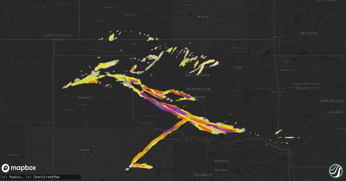
Hail Map in Oklahoma on April 21, 2020
Get this storm
April 21 map
$229
one time, instant access
Download today. No call, no setup
Keep the $229
Bought the map and want the full workflow? Apply the entire $229 to a subscription within 7 days. None of it is wasted.
Every map, not just this one
This buys you this map. Subscription and you get every map we run, in the markets you choose from a few cities to whole states to nationwide. Plus real-time alerts the moment a storm fires.
Contact data
Name, contact info, occupancy, even credit band for addresses in the footprint. You go from where it hit to who to call.
Become the source they trust
Unlimited branding weather history reports on demand. You already have the documented answer ready for the property owner, and you are the one who showed up with it.
Property data and RoofTrace estimates
Pull up any address you have got, its value and the exact code rules for that jurisdiction, straight from One Click Code. Then RoofTrace estimates the squares, pitch, and roof value, priced the way you price.
Storm reports in Oklahoma
Oklahoma
| Date | Description |
|---|---|
| 04/21/20206:48 AM CDT | At 1147 PM CDT, a severe thunderstorm was located near Marlow, moving east at 35 mph. HAZARD...Tennis ball size hail and 70 mph wind gusts. SOURCE...Radar indicated. IMPACT...People and animals outdoors will be injured. Expect hail damage to roofs, siding, windows, and vehicles. Expect considerable tree damage. Wind damage is also likely to mobile homes, roofs, and outbuildings. Locations impacted include... Duncan, Marlow, Rush Springs, Bray, Elmore City, Velma, Katie, Foster, Tatums, Ratliff City, Graham, Pooleville, Antioch, Hennepin, Central High, Fox, Pernell, Cox City and Whitebead. |
| 04/21/20206:43 AM CDT | At 1142 PM CDT, a severe thunderstorm was located 5 miles northwest of Meers, moving southeast at 30 mph. The largest hail is expected to move toward Meers and mainly areas north of Lawton. HAZARD...Tennis ball size hail and 70 mph wind gusts. SOURCE...Radar indicated. IMPACT...People and animals outdoors will be injured. Expect hail damage to roofs, siding, windows, and vehicles. Expect considerable tree damage. Wind damage is also likely to mobile homes, roofs, and outbuildings. Locations impacted include... Lawton, Elgin, Geronimo, Fletcher, Sterling, Medicine Park, Fort Sill, Meers, Lake Ellsworth, Lake Lawtonka and Wichita Mountains Wildlife Refuge. |
| 04/21/20206:39 AM CDT | At 1139 PM CDT, a severe thunderstorm was located near Blanchard, moving east at 25 mph. HAZARD...60 mph wind gusts and quarter size hail. SOURCE...Radar indicated. IMPACT...Hail damage to vehicles is expected. Expect wind damage to roofs, siding, and trees. Locations impacted include... Southern Norman, Newcastle, Blanchard, Purcell, Noble, Slaughterville, Lexington, Goldsby, Dibble, Washington and Cole. |
| 04/21/20206:09 AM CDT | At 1109 PM CDT, a severe thunderstorm was located near Electra, moving northeast at 50 mph. HAZARD...60 mph wind gusts and quarter size hail. SOURCE...Radar indicated. IMPACT...Hail damage to vehicles is expected. Expect wind damage to roofs, siding, and trees. Locations impacted include... Burkburnett, Iowa Park, Electra, Grandfield, Randlett, Devol, Cookietown and Cashion. |
| 04/21/20206:00 AM CDT | At 1059 PM CDT, a severe thunderstorm was located near Amber, moving southeast at 20 mph. The largest hail with this storm is expected to move toward the Blanchard and Cole areas. HAZARD...Two inch hail. SOURCE...Radar indicated. IMPACT...People and animals outdoors will be injured. Expect damage to roofs, siding, windows, and vehicles. Locations impacted include... Southwestern Norman, Newcastle, Blanchard, Tuttle, Goldsby, Dibble, Cole, Amber, Bridge Creek, Pocasset and Middleberg. |
| 04/21/20205:54 AM CDT | At 1053 PM CDT, a severe thunderstorm was located near Boone, moving east at 35 mph. HAZARD...Tennis ball size hail and 60 mph wind gusts. SOURCE...Radar indicated. IMPACT...People and animals outdoors will be injured. Expect hail damage to roofs, siding, windows, and vehicles. Expect wind damage to roofs, siding, and trees. Locations impacted include... Duncan, Marlow, Elgin, Apache, Rush Springs, Fletcher, Cyril, Sterling, Cement, Agawam, Boone, Lake Ellsworth, northeastern Fort Sill, Central High, Acme and Stecker. |
| 04/21/20205:49 AM CDT | At 1048 PM CDT, a severe thunderstorm was located near Hobart, moving southeast at 35 mph. HAZARD...Tennis ball size hail and 70 mph wind gusts. SOURCE...Radar indicated. IMPACT...People and animals outdoors will be injured. Expect hail damage to roofs, siding, windows, and vehicles. Expect considerable tree damage. Wind damage is also likely to mobile homes, roofs, and outbuildings. Locations impacted include... Hobart, Gotebo, Cooperton, Meers, Boone, Lake Lawtonka, southwestern Fort Sill and Wichita Mountains Wildlife Refuge. |
| 04/21/20205:35 AM CDT | From the vance airforce base weather observer via the kend metar. |
| 04/21/20205:33 AM CDT | On the west side of enid. |
| 04/21/20205:32 AM CDT | At 1032 PM CDT, a severe thunderstorm was located 7 miles northeast of Red Springs, moving northeast at 55 mph. HAZARD...Golf ball size hail and 60 mph wind gusts. SOURCE...Radar indicated. IMPACT...People and animals outdoors will be injured. Expect hail damage to roofs, siding, windows, and vehicles. Expect wind damage to roofs, siding, and trees. Locations impacted include... Seymour, Electra, Lake Kemp, Harrold, Grayback, western Lake Diversion and Haynesville. |
| 04/21/20205:30 AM CDT | At 1030 PM CDT, a severe thunderstorm was located near Minco, moving east at 20 mph. HAZARD...60 mph wind gusts and quarter size hail. SOURCE...Radar indicated. IMPACT...Hail damage to vehicles is expected. Expect wind damage to roofs, siding, and trees. Locations impacted include... Southwestern Oklahoma City, Mustang, Tuttle, Union City, Minco, Amber and Pocasset. |
| 04/21/20205:18 AM CDT | At 1018 PM CDT, a severe thunderstorm was located 8 miles southeast of Gotebo, moving east at 25 mph. HAZARD...Golf ball size hail and 60 mph wind gusts. SOURCE...Radar indicated. IMPACT...People and animals outdoors will be injured. Expect hail damage to roofs, siding, windows, and vehicles. Expect wind damage to roofs, siding, and trees. Locations impacted include... Apache, Medicine Park, Meers, Lake Ellsworth, Lake Lawtonka, Boone, Fort Sill, Stecker and northeastern Wichita Mountains Wildlife Refuge. |
| 04/21/20205:01 AM CDT | At 1000 PM CDT, a severe thunderstorm was located near Cogar, moving east at 20 mph. HAZARD...Ping pong ball size hail and 60 mph wind gusts. SOURCE...Radar indicated. IMPACT...People and animals outdoors will be injured. Expect hail damage to roofs, siding, windows, and vehicles. Expect wind damage to roofs, siding, and trees. Locations impacted include... Southwestern Oklahoma City, Mustang, Tuttle, Union City, Minco, Amber, Pocasset and Cogar. |
| 04/21/20204:56 AM CDT | At 956 PM CDT, a severe thunderstorm was located near Cordell, moving southeast at 30 mph. HAZARD...Tennis ball size hail and 70 mph wind gusts. SOURCE...Radar indicated. IMPACT...People and animals outdoors will be injured. Expect hail damage to roofs, siding, windows, and vehicles. Expect considerable tree damage. Wind damage is also likely to mobile homes, roofs, and outbuildings. Locations impacted include... Cordell, Carnegie, Mountain View, Fort Cobb, Corn, Eakly, Gotebo, Colony, Alfalfa, Cloud Chief, Fort Cobb Reservoir, Albert and Cowden. |
| 04/21/20204:54 AM CDT | At 953 PM CDT, a severe thunderstorm was located near Carter, moving southeast at 35 mph. HAZARD...Tennis ball size hail and 70 mph wind gusts. SOURCE...Radar indicated. IMPACT...People and animals outdoors will be injured. Expect hail damage to roofs, siding, windows, and vehicles. Expect considerable tree damage. Wind damage is also likely to mobile homes, roofs, and outbuildings. Locations impacted include... Sayre, Hobart, Granite, Sentinel, Lone Wolf, Carter, Rocky, Retrop and Altus-Lugert Lake. |
| 04/21/20204:46 AM CDT | At 945 PM CDT, a severe thunderstorm was located near Hobart, moving east at 20 mph. HAZARD...Ping pong ball size hail and 60 mph wind gusts. SOURCE...Radar indicated. IMPACT...People and animals outdoors will be injured. Expect hail damage to roofs, siding, windows, and vehicles. Expect wind damage to roofs, siding, and trees. Locations impacted include... Hobart, Mountain View and Gotebo. |
| 04/21/20204:38 AM CDT | Mostly quarter size hail with a few golf ball size hailstones. |
| 04/21/20204:20 AM CDT | At 920 PM CDT, a severe thunderstorm was located near Burns Flat, moving southeast at 35 mph. HAZARD...Two inch hail and 70 mph wind gusts. SOURCE...Radar indicated. IMPACT...People and animals outdoors will be injured. Expect hail damage to roofs, siding, windows, and vehicles. Expect considerable tree damage. Wind damage is also likely to mobile homes, roofs, and outbuildings. Locations impacted include... Cordell, Burns Flat, Dill City, Corn, Bessie, Rocky, Foss, Colony, Cloud Chief and Cowden. |
| 04/21/20204:17 AM CDT | At 917 PM CDT, a severe thunderstorm was located near Sweetwater, moving southeast at 35 mph. HAZARD...Two inch hail and 70 mph wind gusts. SOURCE...Radar indicated. IMPACT...People and animals outdoors will be injured. Expect hail damage to roofs, siding, windows, and vehicles. Expect considerable tree damage. Wind damage is also likely to mobile homes, roofs, and outbuildings. Locations impacted include... Sayre, Carter, Sweetwater and Delhi. |
| 04/21/20204:08 AM CDT | At 908 PM CDT, a severe thunderstorm was located 5 miles northwest of Lookeba, moving east at 20 mph. HAZARD...Golf ball size hail and 60 mph wind gusts. SOURCE...Radar indicated. IMPACT...People and animals outdoors will be injured. Expect hail damage to roofs, siding, windows, and vehicles. Expect wind damage to roofs, siding, and trees. Locations impacted include... El Reno, Hinton, Minco, Binger, Lookeba, Cogar and Cedar Lake. |
| 04/21/20203:45 AM CDT | At 845 PM CDT, a severe thunderstorm was located near Allison, moving southeast at 25 mph. HAZARD...Golf ball size hail and 70 mph wind gusts. SOURCE...Radar indicated. IMPACT...People and animals outdoors will be injured. Expect hail damage to roofs, siding, windows, and vehicles. Expect considerable tree damage. Wind damage is also likely to mobile homes, roofs, and outbuildings. Locations impacted include... Reydon, Sweetwater and Dempsey. |
| 04/21/20203:40 AM CDT | At 839 PM CDT, a severe thunderstorm was located 9 miles southeast of Cheyenne, moving southeast at 35 mph. HAZARD...Tennis ball size hail and 70 mph wind gusts. SOURCE...Radar indicated. IMPACT...People and animals outdoors will be injured. Expect hail damage to roofs, siding, windows, and vehicles. Expect considerable tree damage. Wind damage is also likely to mobile homes, roofs, and outbuildings. Locations impacted include... Elk City, Clinton, Burns Flat, Hammon, Dill City, Canute, Foss, Foss Reservoir, Stafford and Berlin. |
| 04/21/20203:24 AM CDT | At 824 PM CDT, a severe thunderstorm was located near Lake Chickasha, moving east at 15 mph. HAZARD...Ping pong ball size hail and 60 mph wind gusts. SOURCE...Radar indicated. IMPACT...People and animals outdoors will be injured. Expect hail damage to roofs, siding, windows, and vehicles. Expect wind damage to roofs, siding, and trees. Locations impacted include... Tuttle, Amber, Pocasset and Lake Chickasha. |
| 04/21/20203:17 AM CDT | At 817 PM CDT, a severe thunderstorm was located near Corn, moving east at 20 mph. HAZARD...Golf ball size hail and 60 mph wind gusts. SOURCE...Radar indicated. IMPACT...People and animals outdoors will be injured. Expect hail damage to roofs, siding, windows, and vehicles. Expect wind damage to roofs, siding, and trees. Locations impacted include... Hinton, Binger, Corn, Eakly, Lookeba, Colony and Bridgeport. |
| 04/21/20203:13 AM CDT | At 813 PM CDT, a severe thunderstorm was located 5 miles east of Reydon, moving east at 25 mph. HAZARD...Two inch hail and 70 mph wind gusts. SOURCE...Radar indicated. IMPACT...People and animals outdoors will be injured. Expect hail damage to roofs, siding, windows, and vehicles. Expect considerable tree damage. Wind damage is also likely to mobile homes, roofs, and outbuildings. Locations impacted include... Cheyenne, Hammon, Reydon, Strong City, Moorewood, Roll, Berlin and Dempsey. |
| 04/21/20203:06 AM CDT | At 806 PM CDT, a severe thunderstorm was located 7 miles west of Elk City, moving northeast at 20 mph. HAZARD...Golf ball size hail and 60 mph wind gusts. SOURCE...Radar indicated. IMPACT...People and animals outdoors will be injured. Expect hail damage to roofs, siding, windows, and vehicles. Expect wind damage to roofs, siding, and trees. Locations impacted include... Elk City, Hammon, Canute, Foss, Foss Reservoir and Berlin. |
| 04/21/20202:54 AM CDT | At 754 PM CDT, a severe thunderstorm was located near Lora, or 9 miles northeast of Miami, moving southeast at 30 mph. HAZARD...60 mph wind gusts and quarter size hail. SOURCE...Radar indicated. IMPACT...Minor damage to roofs, siding, and trees is possible. Hail damage to vehicles is expected. Locations impacted include... Allison and Lora. |
| 04/21/20202:50 AM CDT | A local report indicates 1.00 inch wind near 10 W CANEY |
| 04/21/20202:40 AM CDT | At 740 PM CDT, a severe thunderstorm was located near Anadarko, moving northeast at 10 mph. HAZARD...Ping pong ball size hail and 60 mph wind gusts. SOURCE...Radar indicated. IMPACT...People and animals outdoors will be injured. Expect hail damage to roofs, siding, windows, and vehicles. Expect wind damage to roofs, siding, and trees. Locations impacted include... Chickasha, Anadarko, Verden, Gracemont, Cogar and Lake Chickasha. |
| 04/21/20202:35 AM CDT | A local report indicates 1.75 inch wind near 5 NW ARDMORE |
| 04/21/20202:35 AM CDT | A local report indicates 81 MPH wind near 7 WNW ARDMORE |
| 04/21/20202:24 AM CDT | At 724 PM CDT, a severe thunderstorm was located near Bessie, moving northeast at 10 mph. HAZARD...Golf ball size hail and 60 mph wind gusts. SOURCE...Radar indicated. IMPACT...People and animals outdoors will be injured. Expect hail damage to roofs, siding, windows, and vehicles. Expect wind damage to roofs, siding, and trees. Locations impacted include... Clinton, Cordell, Arapaho, Corn, Bessie and Colony. |
| 04/21/20202:20 AM CDT | Transformer damaged and power out in tishomingo. |
| 04/21/20202:20 AM CDT | Relayed by media via twitter. |
| 04/21/20202:15 AM CDT | At 715 PM CDT, a severe thunderstorm was located 5 miles south of Lake Marvin, moving east at 25 mph. HAZARD...Two inch hail and 60 mph wind gusts. SOURCE...Radar indicated. IMPACT...People and animals outdoors will be injured. Expect hail damage to roofs, siding, windows, and vehicles. Expect wind damage to roofs, siding, and trees. Locations impacted include... Cheyenne, Reydon, Strong City, Crawford, Roll, Durham and Dempsey. |
| 04/21/20202:12 AM CDT | Also had 45 mph wind gusts reported. |
| 04/21/20202:02 AM CDT | A local report indicates 1.00 inch wind near FILLMORE |
| 04/21/20201:48 AM CDT | A local report indicates 1.00 inch wind near 5 E TISHOMINGO |
| 04/21/20201:30 AM CDT | A local report indicates 1.00 inch wind near 7 N RAVIA |
| 04/21/20201:20 AM CDT | Relayed via twitter |
| 04/21/20201:12 AM CDT | A local report indicates 1.75 inch wind near 3 NE GENE AUTRY |
| 04/21/202012:55 AM CDT | A local report indicates 1.00 inch wind near 5 W DOUGHERTY |
| 04/21/202012:18 AM CDT | A local report indicates 1.25 inch wind near DUNCAN |
| 04/21/202012:17 AM CDT | A local report indicates 1.75 inch wind near DUNCAN |
| 04/21/202012:15 AM CDT | A local report indicates 1.25 inch wind near DUNCAN |
| 04/21/202012:10 AM CDT | A local report indicates 1.00 inch wind near MEDICINE PARK |
| 04/21/202012:10 AM CDT | A local report indicates 60 MPH wind near 7 NW VELMA |
| 04/21/202012:04 AM CDT | A local report indicates 1.00 inch wind near 6 S STERLING |
| 04/20/202011:57 PM CDT | A local report indicates 1.00 inch wind near 3 E WALTERS |
| 04/20/202011:47 PM CDT | A local report indicates 1.50 inch wind near MEERS |
| 04/20/202011:45 PM CDT | A local report indicates 2.75 inch wind near DEVOL |
| 04/20/202011:40 PM CDT | Large trees down and power lines down. Time based on radar. |
| 04/20/202011:25 PM CDT | A local report indicates 2.00 inch wind near STERLING |
| 04/20/202011:22 PM CDT | A local report indicates 2.00 inch wind near 2 NNE COOPERTON |
| 04/20/202011:19 PM CDT | A local report indicates 1.75 inch wind near 3 E STERLING |
| 04/20/202011:15 PM CDT | A local report indicates 1.75 inch wind near 2 E ELGIN |
| 04/20/202011:12 PM CDT | A local report indicates 60 MPH wind near 2 WNW ELGIN |
| 04/20/202011:11 PM CDT | A local report indicates 3.00 inch wind near ELGIN |
| 04/20/202011:00 PM CDT | A local report indicates 70 MPH wind near 3 NNE AMBER |
| 04/20/202010:57 PM CDT | A local report indicates 60 MPH wind near 2 SE HOBART |
| 04/20/202010:47 PM CDT | Report from mping. |
| 04/20/202010:47 PM CDT | A local report indicates 2.50 inch wind near 1 S POCASSET |
| 04/20/202010:44 PM CDT | Report from mping. |
| 04/20/202010:33 PM CDT | A local report indicates 1.00 inch wind near 1 S MINCO |
| 04/20/202010:32 PM CDT | A local report indicates 1.75 inch wind near POCASSET |
| 04/20/202010:08 PM CDT | A local report indicates 1.75 inch wind near 5 SSW CLOUD CHIEF |
| 04/20/202010:00 PM CDT | Time estimated from radar. |
| 04/20/20209:59 PM CDT | A local report indicates 59 MPH wind near 2 WSW BURNS FLAT |
| 04/20/20209:49 PM CDT | A local report indicates 2.75 inch wind near 1 N SAYRE |
| 04/20/20209:40 PM CDT | Report from mping. |
| 04/20/20209:39 PM CDT | A local report indicates 1.25 inch wind near 4 W SAYRE |
| 04/20/20209:36 PM CDT | Twitter pic. |
| 04/20/20209:31 PM CDT | A local report indicates 1.50 inch wind near 2 N BINGER |
| 04/20/20209:24 PM CDT | A local report indicates 68 MPH wind near 2 WSW BURNS FLAT |
| 04/20/20209:16 PM CDT | A local report indicates 65 MPH wind near 2 WSW BURNS FLAT |
| 04/20/20209:06 PM CDT | Report from mping. |
| 04/20/20209:05 PM CDT | A local report indicates 2.50 inch wind near 2 ENE ELK CITY |
| 04/20/20209:05 PM CDT | A local report indicates 1.25 inch wind near 4 SW CANUTE |
| 04/20/20208:35 PM CDT | Twitter pic. |
| 04/20/20208:34 PM CDT | A local report indicates 2.00 inch wind near 3 ENE ELK CITY |
| 04/20/20208:30 PM CDT | Twitter pic. |
| 04/20/20208:18 PM CDT | A local report indicates 1.75 inch wind near 7 NW CHEYENNE |
| 04/20/20208:02 PM CDT | A local report indicates 1.75 inch wind near 6 N REYDON |
| 04/20/20207:50 PM CDT | A local report indicates 1.00 inch wind near 4 SSW BERLIN |
| 04/20/20207:42 PM CDT | A local report indicates 1.00 inch wind near ANADARKO |
All States Impacted by Hail Map on April 21, 2020
Cities Impacted by Hail Map on April 21, 2020
- Atoka, OK
- Minco, OK
- Chickasha, OK
- Tuttle, OK
- Amber, OK
- Pocasset, OK
- Elk City, OK
- Canute, OK
- Cement, OK
- Randlett, OK
- Mountain View, OK
- Gotebo, OK
- Spearman, TX
- Duncan, OK
- Sayre, OK
- Wilton, AR
- Ashdown, AR
- Goree, TX
- Weinert, TX
- Munday, TX
- Rule, TX
- O'Brien, TX
- Knox City, TX
- Old Glory, TX
- Rochester, TX
- Comanche, OK
- Canadian, TX
- Briscoe, TX
- Reydon, OK
- Durham, OK
- Fletcher, OK
- Elgin, OK
- Apache, OK
- Rush Springs, OK
- Marlow, OK
- Gillham, AR
- De Queen, AR
- Eagletown, OK
- Nashville, AR
- Mineral Springs, AR
- Pampa, TX
- Alva, OK
- Dacoma, OK
- Enid, OK
- Lane, OK
- Mooreland, OK
- Lawton, OK
- Seymour, TX
- Electra, TX
- Iowa Park, TX
- Hobart, OK
- Waynoka, OK
- Chester, OK
- Madill, OK
- Miami, TX
- Lone Grove, OK
- Ardmore, OK
- Coldwater, KS
- Freedom, OK
- Marshall, OK
- Douglas, OK
- Davis, OK
- Springer, OK
- Sulphur, OK
- Tishomingo, OK
- Mill Creek, OK
- Caney, OK
- Caddo, OK
- Helena, OK
- Gage, OK
- Channing, TX
- Masterson, TX
- Hennepin, OK
- Foster, OK
- Healdton, OK
- Sentinel, OK
- Mannsville, OK
- Carter, OK
- Lone Wolf, OK
- Graham, OK
- Loco, OK
- Bennington, OK
- Fort Sill, OK
- Carnegie, OK
- Roosevelt, OK
- Wapanucka, OK
- Ratliff City, OK
- Kenefic, OK
- Wilson, OK
- Medicine Park, OK
- Boswell, OK
- Coleman, OK
- Elmore City, OK
- Antlers, OK
- Milburn, OK
- Haskell, TX
- Stamford, TX
- Throckmorton, TX
- Aspermont, TX
- Woodward, OK
- Pawnee, OK
- Morrison, OK
- Hooker, OK
- Fort Towson, OK
- Perryton, TX
- Stinnett, TX
- Washington, OK
- Lockesburg, AR
- Borger, TX
- Hugo, OK
- Crescent, OK
- Perry, OK
- Orlando, OK
- Guthrie, OK
- Stillwater, OK
- Mulhall, OK
- Arnett, OK
- Cherokee, OK
- Carmen, OK
- Dill City, OK
- Foss, OK
- Liberal, KS
- Turpin, OK
- Hugoton, KS
- Kismet, KS
- Wheeler, TX
- Sweetwater, OK
- Devol, OK
- Burkburnett, TX
- Fargo, OK
- Sharon, OK
- Shattuck, OK
- Higgins, TX
- Idabel, OK
- Hamlin, TX
- Skellytown, TX
- Blanchard, OK
- Dougherty, OK
- Durant, OK
- Erick, OK
- Ringling, OK
- Englewood, KS
- Grandfield, OK
- Dumas, TX
- Cheyenne, OK
- Binger, OK
- Tussy, OK
- Walters, OK
- Gracemont, OK
- Bessie, OK
- Cordell, OK
- Corn, OK
- Cyril, OK
- Soper, OK
- Anadarko, OK
- Crawford, OK
- Hydro, OK
- Butler, OK
- Wynnewood, OK
- Hinton, OK
- Lookeba, OK
- Colony, OK
- Temple, OK
- Buffalo, OK
- Sunray, TX
- Fritch, TX
- Protection, KS
- Pond Creek, OK
- Garber, OK
- Drummond, OK
- Waukomis, OK
- Carrier, OK
- Ames, OK
- Lahoma, OK
- Kremlin, OK
- Nash, OK
- Fairmont, OK
- Meno, OK
- Morse, TX
- Vega, TX
- Vici, OK
- Glencoe, OK
- Coalgate, OK
- Fort Cobb, OK
- Haworth, OK
- Covington, OK
- Horatio, AR
- Hennessey, OK
- Lucien, OK
- Beaver, OK
- Ashland, KS
- Rosston, OK
- Red Rock, OK
- Billings, OK
- Marietta, OK
- Bokchito, OK
- Plains, KS
- Dover, OK
- Hunter, OK
- Ringwood, OK
- Tupelo, OK
- Follett, TX
- Jennings, LA
- Medford, OK
- Leedey, OK
- Fort Supply, OK
- Mutual, OK
- Branch, LA
- Goltry, OK
- Jet, OK
- Centrahoma, OK
- Booker, TX
- Meade, KS
- Clarksville, TX
- McCaskill, AR
- Welsh, LA
- Bridgeport, NJ
- Swedesboro, NJ
- Claymont, DE
- Marcus Hook, PA
- Chester, PA
- Gibbstown, NJ
- Paulsboro, NJ
- Essington, PA
- Crum Lynne, PA
- Philadelphia, PA
- Ridley Park, PA
- Lewes, DE
- Absecon, NJ
- Egg Harbor Township, NJ
- Cape May Point, NJ
- Cape May, NJ
- Mill Neck, NY
- New York, NY
- Port Washington, NY
- Englewood Cliffs, NJ
- Fort Lee, NJ
- Glen Head, NY
- Locust Valley, NY
- Sea Cliff, NY
- Bronx, NY
- Glen Cove, NY
- Oyster Bay, NY
- El Reno, OK
- Hammon, OK


