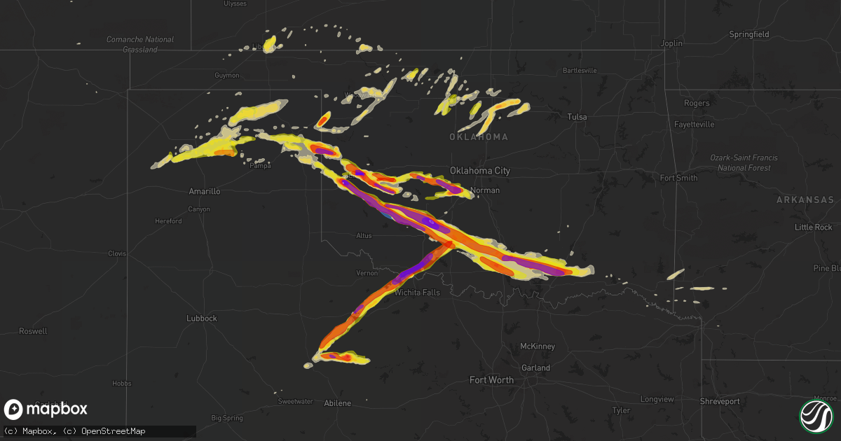
Hail Map on April 21, 2020
Get this storm
April 21 map
$229
one time, instant access
Download today. No call, no setup
Keep the $229
Bought the map and want the full workflow? Apply the entire $229 to a subscription within 7 days. None of it is wasted.
Every map, not just this one
This buys you this map. Subscription and you get every map we run, in the markets you choose from a few cities to whole states to nationwide. Plus real-time alerts the moment a storm fires.
Contact data
Name, contact info, occupancy, even credit band for addresses in the footprint. You go from where it hit to who to call.
Become the source they trust
Unlimited branding weather history reports on demand. You already have the documented answer ready for the property owner, and you are the one who showed up with it.
Property data and RoofTrace estimates
Pull up any address you have got, its value and the exact code rules for that jurisdiction, straight from One Click Code. Then RoofTrace estimates the squares, pitch, and roof value, priced the way you price.
States Impacted by Hail Map on April 21, 2020
Storm reports
Maryland
| Date | Description |
|---|---|
| 04/21/20203:03 PM CDT | Tree down on a house in ocean pines. |
| 04/21/20203:01 PM CDT | Power lines knocked down. Time estimated from radar. |
| 04/21/20202:10 PM CDT | Power lines knocked down. Time estimated from radar. |
| 04/21/20201:23 PM CDT | A few reports of power lines down in the area. Time estimated from radar. |
| 04/21/20201:22 PM CDT | Downed wires reported. Time estimated from radar. |
| 04/21/20201:08 PM CDT | Tree uprooted. Time based on radar. |
| 04/21/20201:08 PM CDT | Several trees down near state highway 298. Time estimated from radar. |
| 04/20/20208:49 PM CDT | At 149 PM EDT, a severe thunderstorm was located over Talleyville, or near Wilmington, moving east at 55 mph. HAZARD...60 mph wind gusts and penny size hail. SOURCE...Radar indicated. IMPACT...Damage to roofs, siding, trees, and power lines is possible. Locations impacted include... Philadelphia, Camden, Wilmington, Vineland, Newark, Millville, Bridgeton, Middletown, Elkton, Gloucester City, Cumberland, Cherry Hill, Evesham, Mount Laurel, Chester, Deptford, Voorhees, West Deptford, Glassboro and Lindenwold.People attending Covid-19 Drive through testing should seek safeshelter immediately!This includes the following highways... Atlantic City Expressway between mile markers 33 and 44. Interstate 295 in New Jersey between mile markers 0 and 41. Interstate 95 in Pennsylvania between mile markers 0 and 25. Interstate 95 in Maryland between mile markers 107 and 109. New Jersey Turnpike between exits 1 and 4. Interstate 95 in Delaware between mile markers 0 and 23. Interstate 476 in Pennsylvania between mile markers 0 and 11. Interstate 676 in New Jersey between mile markers 0 and 4. Interstate 676 in Pennsylvania between mile markers 0 and 1. Interstate 76 in New Jersey between mile markers 0 and 3. Interstate 76 in Pennsylvania between mile markers 341 and 351. |
Pennsylvania
| Date | Description |
|---|---|
| 04/21/20201:07 PM CDT | 59 mph wind gust measured at kphl. |
| 04/21/20201:07 PM CDT | 59 mph wind gust measured at kphl. This corrects a previous lsr. |
| 04/21/20201:05 PM CDT | Phl itws measured 61 mph at 2:05 pm. |
| 04/21/20201:05 PM CDT | 61 mph measured wind gust at kphl itws. |
| 04/21/202012:58 PM CDT | Downed wires near kemble park. Time estimated from radar. |
| 04/21/202012:26 PM CDT | Downed trees and wires. Time estimated from radar. |
| 04/21/202012:18 PM CDT | Downed tree near the intersection of reeceville road and swinehart road. Time estimated from radar. |
| 04/21/202012:15 PM CDT | Downed tree near the intersection of reeceville road and swinehart road. Time estimated from radar. |
| 04/21/202012:04 PM CDT | 1 inch tree limbs broken and shingles blown off of roof. Report from mping. |
| 04/20/20208:59 PM CDT | At 154 PM EDT, severe thunderstorms were located along a line extending from near Monsey to Belle Mead to Kensington, moving east at 40 mph. HAZARD...60 mph wind gusts. SOURCE...Radar indicated. IMPACT...Damage to roofs, siding, trees, and power lines is possible. Locations impacted include... Philadelphia, Toms River, Trenton, Camden, New Brunswick, Perth Amboy, Long Branch, Morristown, Asbury Park, Somerville, Sandy Hook, Somerset, Edison, Lakewood, Middletown, Old Bridge, Bensalem, Jackson, Howell and East Brunswick.People attending Covid-19 Drive through testing should seek safeshelter immediately!This includes the following highways... Garden State Parkway between mile markers 63 and 134. Interstate 195 in New Jersey between mile markers 0 and 34. Interstate 287 in New Jersey between mile markers 0 and 20, andbetween mile markers 25 and 53. Interstate 295 in New Jersey between mile markers 35 and 76. Interstate 78 in New Jersey between mile markers 32 and 42. Interstate 80 in New Jersey between mile markers 42 and 47. Interstate 95 in Pennsylvania between mile markers 22 and 40. New Jersey Turnpike between exits 4 and 13. Pennsylvania Turnpike between exits 351 and 353. Interstate 76 in Pennsylvania between mile markers 339 and 342. |
| 04/20/20208:28 PM CDT | At 127 PM EDT, severe thunderstorms were located along a line extending from Wharton to near Washington Crossing to Lima, moving east at 40 mph. HAZARD...60 mph wind gusts. SOURCE...Radar indicated. IMPACT...Damage to roofs, siding, trees, and power lines is possible. Locations impacted include... Philadelphia, Trenton, Camden, New Brunswick, Morristown, Somerville, Somerset, Bensalem, East Brunswick, Bridgewater, South Brunswick, Mount Laurel, North Brunswick, Ewing, Willingboro, Dover, Madison, Hopatcong, Middlesex and Princeton.People attending Covid-19 Drive through testing should seek safeshelter immediately!This includes the following highways... Interstate 195 in New Jersey between mile markers 0 and 7. Interstate 287 in New Jersey between mile markers 3 and 47. Interstate 295 in New Jersey between mile markers 35 and 76. Interstate 78 in New Jersey between mile markers 22 and 42. Interstate 80 in New Jersey between mile markers 29 and 48. Interstate 95 in Pennsylvania between mile markers 22 and 40. New Jersey Turnpike between exits 4 and 8, and between exits 9 and10. Pennsylvania Turnpike between exits 339 and 353. Interstate 76 in Pennsylvania between mile markers 332 and 342. |
New Jersey
| Date | Description |
|---|---|
| 04/21/20202:35 PM CDT | Several reports of downed power lines. Time estimated from radar. |
| 04/21/20202:30 PM CDT | Several reports of structural damage in little egg harbor. Time estimated from radar. |
| 04/21/20202:29 PM CDT | Beach haven mesonet measures 58 mph wind gust. |
| 04/21/20202:27 PM CDT | A local report indicates 69 MPH wind near 1 ENE CAPE MAY POINT |
| 04/21/20202:26 PM CDT | Several reports of power lines down in the area. Time estimated from radar. |
| 04/21/20202:25 PM CDT | Tree down... Transformers blown. |
| 04/21/20202:21 PM CDT | Kacy measures 60 mph wind gust. |
| 04/21/20202:18 PM CDT | Corrects previous tstm wnd gst report from atlantic city international airport |
| 04/21/20202:08 PM CDT | Several reports of power lines and tree limbs down in the toms river area. Time estimated from radar. |
| 04/21/20202:08 PM CDT | Several reports of downed trees and wires. Time estimated from radar. |
| 04/21/20202:04 PM CDT | Downed utility pole on state highway 35 south of lakewood road. Time estimated from radar. |
| 04/21/20202:04 PM CDT | Tree down on standish dr. In bellcrest area of toms river. Time estimated from radar. |
| 04/21/20202:04 PM CDT | Several reports of trees and wires down near and west of manasquan. Time estimated from radar. |
| 04/21/20202:03 PM CDT | Multiple trees uprooted in toms river near vaughn ave and n tunesbrook dr. Time estimated from radar. |
| 04/21/20202:00 PM CDT | Hooper ave & cedar bridge ave are closed due to wires down. |
| 04/21/20202:00 PM CDT | Trees and wires into homes near brick nj... Time estimated from radar. |
| 04/21/20201:58 PM CDT | Damage to trailers and sheds at sea girt training center... Time estimated from radar. |
| 04/21/20201:56 PM CDT | Downed trees and wires. Time estimated from radar. |
| 04/21/20201:51 PM CDT | Downed wires on nj70 in cherry hill. |
| 04/21/20201:50 PM CDT | Several reports of tree limbs and power lines down. |
| 04/21/20201:48 PM CDT | Downed utility pole on business state highway 33 near west main street. Time estimated from radar. |
| 04/21/20201:40 PM CDT | Several reports of tree limbs and power lines down in the browns mills area. Time estimated from radar. |
| 04/21/20201:38 PM CDT | Downed tree and wires. Time estimated from radar. |
| 04/21/20201:36 PM CDT | Several reports of trees and power lines down between pemberton and browns mills. Time estimated from radar. |
| 04/21/20201:35 PM CDT | Trees down in medford... Nj. Time estimated from radar. |
| 04/21/20201:31 PM CDT | Nj 511 reports a tree down on the garden state parkway southbound... South of exit 149. |
| 04/21/20201:30 PM CDT | Several tree limbs downed. |
| 04/21/20201:25 PM CDT | Dozens of reports of power lines and trees down in a swath from brooklawn to haddonfield. |
| 04/21/20201:24 PM CDT | 1-inch tree limbs broken and shingles blown off. |
| 04/21/20201:23 PM CDT | Downed tree on wires near neptune lane. |
| 04/21/20201:21 PM CDT | Several photos of trees down in the area. Time estimated from radar. |
| 04/21/20201:20 PM CDT | Tree down on house. |
| 04/21/20201:20 PM CDT | Large tree uprooted and fell on suv on laurel avenu. |
| 04/21/20201:20 PM CDT | Downed tree on interstate 295 southbound ramp from haddonfield berlin road. Time estimated from radar. |
| 04/21/20201:20 PM CDT | Reports of power lines down. |
| 04/21/20201:20 PM CDT | Downed tree on wires near neptune lane. Time estimated from radar. |
| 04/21/20201:16 PM CDT | Downed wires from strong winds. Time estimated from radar. |
| 04/21/20201:16 PM CDT | Downed pole and wires on state highway 41 near clements bridge road. |
| 04/21/20201:15 PM CDT | Multiple trees down in haddon heights... Nj. Time estimated from radar. |
| 04/21/20201:14 PM CDT | Mping report of trees uprooted at this location. Time estimated from radar. |
| 04/21/20201:13 PM CDT | Nj 511 reports a tree down on the garden state parkway southbound... South of exit 149. |
| 04/21/20201:10 PM CDT | A swath of wind damage was reported from brooklawn to east of haddonfield. Numerous power outages in the area... With several trees and power lines downed. Time estimat |
| 04/21/20201:07 PM CDT | Trained spotter reports trees and power lines down in brooklawn... Nj. |
| 04/21/20201:02 PM CDT | Several trees down near quakerbridge mall. Time estimated from radar. |
| 04/21/20201:00 PM CDT | Nj mesonet site reported 66 mph wind gust. |
| 04/20/20209:55 PM CDT | At 255 PM EDT, severe thunderstorms were located along a line extending from near Highlands to Pleasant Plains to Chatsworth, moving east at 55 mph. HAZARD...60 mph wind gusts. SOURCE...Radar indicated. IMPACT...Damage to roofs, siding, trees, and power lines is possible. Locations impacted include... Toms River, Long Branch, Asbury Park, Lakewood, Howell, Barnegat, Tinton Falls, Red Bank, Beachwood, Manasquan, Highlands, Point Pleasant Beach, Seaside Heights, Lakehurst, Farmingdale, Surf City, Mantoloking, Allenwood, Elberon and Navesink.This includes the following highways... Garden State Parkway between mile markers 61 and 111. Interstate 195 in New Jersey between mile markers 28 and 34. |
| 04/20/20209:46 PM CDT | At 246 PM EDT, severe thunderstorms were located along a line extending from near Greenwich to near Andrewsville to near University Of Maryland Center For Environmental Studies, moving east at 40 mph. HAZARD...60 mph wind gusts and penny size hail. SOURCE...Radar indicated. IMPACT...Damage to roofs, siding, trees, and power lines is possible. Locations impacted include... Dover, Georgetown, Smyrna, Milford, Seaford, Denton, Millsboro, Laurel, Harrington, Camden, Lewes, Federalsburg, Milton, Selbyville, Bridgeville, Greensboro, Delmar, Cheswold, Trappe and Dagsboro. |
| 04/20/20209:40 PM CDT | At 239 PM EDT, severe thunderstorms were located along a line extending from 6 miles east of Yorktown Heights to Cardinal Spellman Hs, moving east at 45 mph. HAZARD...60 mph wind gusts. SOURCE...Radar indicated. IMPACT...Expect damage to trees and power lines. Severe thunderstorms will be near... Bedford around 245 PM EDT. Port Chester and Rye around 250 PM EDT. New Canaan and Georgetown around 255 PM EDT. Wilton and Redding around 300 PM EDT. Westport and Weston around 305 PM EDT. Fairfield and Trumbull around 310 PM EDT. |
| 04/20/20209:12 PM CDT | At 211 PM EDT, severe thunderstorms were located along a line extending from near Ridgewood to Rocky Hill, moving east at 35 mph. HAZARD...60 mph wind gusts. SOURCE...Radar indicated. IMPACT...Expect damage to trees and power lines. Severe thunderstorms will be near... Paterson and Wayne around 215 PM EDT. Paramus around 220 PM EDT. Hackensack and Oradell around 225 PM EDT. Bergenfield and Englewood around 230 PM EDT. Fort Lee and Riverdale around 235 PM EDT. Yonkers and East Tremont around 240 PM EDT. New Rochelle and Bronxville around 245 PM EDT. Throgs Neck Bridge and City Island around 250 PM EDT. |
| 04/20/20209:04 PM CDT | At 204 PM EDT, severe thunderstorms were located along a line extending from near Aberdeen Proving Ground to near Kent Point, moving east at 50 mph. HAZARD...60 mph wind gusts and penny size hail. SOURCE...Radar indicated. IMPACT...Damage to roofs, siding, trees, and power lines is possible. Locations impacted include... Dover, Middletown, Easton, Centerville, Talbot, Smyrna, Milford, Chestertown, Denton, Centreville, Harrington, Camden, Clayton, Bridgeville, Greensboro, Oakland, Ridgely, Cheswold, Rock Hall and St. Michaels.People attending Covid-19 Drive through testing should seek safeshelter immediately! |
| 04/20/20208:56 PM CDT | At 154 PM EDT, severe thunderstorms were located along a line extending from near Pompton Lakes to near Skillman, moving east at 35 mph. HAZARD...60 mph wind gusts and quarter size hail. SOURCE...Radar indicated. IMPACT...Minor hail damage to vehicles is possible. Expect wind damage to trees and power lines.PRECAUTIONARY/PREPAREDNESS ACTIONS...For your protection move to an interior room on the lowest floor of abuilding.Large hail and damaging winds and continuous cloud to groundlightning is occurring with these storms. Move indoors immediately.Lightning is one of nature's leading killers. Remember, if you canhear thunder, you are close enough to be struck by lightning. |
Connecticut
| Date | Description |
|---|---|
| 04/20/202010:25 PM CDT | At 324 PM EDT, severe thunderstorms were located along a line extending from Bristol to near Bridgeport, moving northeast at 45 mph. HAZARD...60 mph wind gusts and quarter size hail. SOURCE...Radar indicated. IMPACT...Minor hail damage to vehicles is possible. Expect wind damage to trees and power lines. Severe thunderstorms will be near... Orange around 340 PM EDT. New Haven around 345 PM EDT. Branford and North Branford around 355 PM EDT. North Branford around 400 PM EDT. Guilford and North Madison around 405 PM EDT. Clinton and Killingworth around 410 PM EDT. Chester and Haddam around 415 PM EDT. |
Delaware
| Date | Description |
|---|---|
| 04/21/20202:30 PM CDT | A local report indicates 65 MPH wind near 1 ENE LEWES |
| 04/21/20201:50 PM CDT | Damaged utility pole from strong winds. Time estimated from radar. |
| 04/21/20201:08 PM CDT | A couple of reports of tree limbs and wires down in the area. Time estimated from radar. |
| 04/21/202012:54 PM CDT | A couple of reports of downed wires. Time estimated from radar. |
| 04/20/202010:46 PM CDT | At 345 PM EDT, severe thunderstorms were located along a line extending from near Gumboro to near Fruitland, moving east at 50 mph. HAZARD...60 mph wind gusts. SOURCE...Radar indicated. IMPACT...Expect damage to trees and powerlines. Severe thunderstorms will be near, Ocean Pines around 400 PM EDT. Newark around 405 PM EDT. Berlin and Cape Isle Of Wight around 415 PM EDT. Ocean City around 420 PM EDT.Other locations impacted by these severe thunderstorms includeBishop, Ocean City Municipality, Salisbury-Wicomico, Bishopville,Ironshire, Willards, Lakewood, West Ocean City, Longridge andChesapeake Heights.People at Peninsula Regional Medical Center, and Perdue Stadiumshould seek safe shelter immediately! |
| 04/20/20209:35 PM CDT | At 235 PM EDT, severe thunderstorms were located along a line extending from Easton to near Taylors Island, moving east at 45 mph. HAZARD...60 mph wind gusts. SOURCE...Radar indicated. IMPACT...Expect damage to trees and powerlines. Severe thunderstorms will be near, University Of Maryland Center For Environmental Studies around 255 PM EDT. Cambridge around 300 PM EDT. Vienna around 315 PM EDT.Other locations impacted by these severe thunderstorms includeGalestown, Wetipquin, Brookview, Eldorado, Hudson, Church Creek,Lloyds, Mardela Springs, Taylors Island and Woolford.People at Dorchester General Hospital should seek safe shelterimmediately! |
| 04/20/20209:24 PM CDT | At 223 PM EDT, severe thunderstorms were located along a line extending from near Medford to Williamstown to 6 miles northeast of Green Spring, moving east at 55 mph. HAZARD...60 mph wind gusts. SOURCE...Radar indicated. IMPACT...Damage to roofs, siding, trees, and power lines is possible. Locations impacted include... Vineland, Atlantic City, Millville, Bridgeton, Ocean City, Cape May, Cumberland, Evesham, Voorhees, Pleasantville, Glassboro, Lindenwold, Hammonton, Somers Point, Ventnor City, Brigantine, Northfield, Absecon, Clayton and Berlin.This includes the following highways... Atlantic City Expressway between mile markers 0 and 43. Garden State Parkway between mile markers 0 and 64. |
| 04/20/20208:04 PM CDT | At 103 PM EDT, severe thunderstorms were located along a line extending from Pleasant Valley to near Green Lane to near Parkesburg, moving east at 40 mph. HAZARD...60 mph wind gusts. SOURCE...Radar indicated. IMPACT...Damage to roofs, siding, trees, and power lines is possible. Locations impacted include... Philadelphia, West Chester, Norristown, Pottstown, Phoenixville, Lansdale, West Norriton, East Norriton, Coatesville, Westtown, Quakertown, Perkasie, Doylestown, Byram, Downingtown, Conshohocken, Hatboro, Souderton, Bedminster and Washington.This includes the following highways... Interstate 78 in New Jersey between mile markers 0 and 27. Interstate 476 in Pennsylvania between mile markers 9 and 19. Pennsylvania Turnpike between exits 312 and 343. Northeast Extension between exits A20 and A31. Interstate 76 in Pennsylvania between mile markers 327 and 336. |
Kansas
| Date | Description |
|---|---|
| 04/21/20202:40 AM CDT | Report from social media. Time estimated from radar. |
| 04/21/20202:27 AM CDT | A local report indicates 1.00 inch wind near 1 E LIBERAL |
Oklahoma
| Date | Description |
|---|---|
| 04/21/20206:48 AM CDT | At 1147 PM CDT, a severe thunderstorm was located near Marlow, moving east at 35 mph. HAZARD...Tennis ball size hail and 70 mph wind gusts. SOURCE...Radar indicated. IMPACT...People and animals outdoors will be injured. Expect hail damage to roofs, siding, windows, and vehicles. Expect considerable tree damage. Wind damage is also likely to mobile homes, roofs, and outbuildings. Locations impacted include... Duncan, Marlow, Rush Springs, Bray, Elmore City, Velma, Katie, Foster, Tatums, Ratliff City, Graham, Pooleville, Antioch, Hennepin, Central High, Fox, Pernell, Cox City and Whitebead. |
| 04/21/20206:43 AM CDT | At 1142 PM CDT, a severe thunderstorm was located 5 miles northwest of Meers, moving southeast at 30 mph. The largest hail is expected to move toward Meers and mainly areas north of Lawton. HAZARD...Tennis ball size hail and 70 mph wind gusts. SOURCE...Radar indicated. IMPACT...People and animals outdoors will be injured. Expect hail damage to roofs, siding, windows, and vehicles. Expect considerable tree damage. Wind damage is also likely to mobile homes, roofs, and outbuildings. Locations impacted include... Lawton, Elgin, Geronimo, Fletcher, Sterling, Medicine Park, Fort Sill, Meers, Lake Ellsworth, Lake Lawtonka and Wichita Mountains Wildlife Refuge. |
| 04/21/20206:39 AM CDT | At 1139 PM CDT, a severe thunderstorm was located near Blanchard, moving east at 25 mph. HAZARD...60 mph wind gusts and quarter size hail. SOURCE...Radar indicated. IMPACT...Hail damage to vehicles is expected. Expect wind damage to roofs, siding, and trees. Locations impacted include... Southern Norman, Newcastle, Blanchard, Purcell, Noble, Slaughterville, Lexington, Goldsby, Dibble, Washington and Cole. |
| 04/21/20206:09 AM CDT | At 1109 PM CDT, a severe thunderstorm was located near Electra, moving northeast at 50 mph. HAZARD...60 mph wind gusts and quarter size hail. SOURCE...Radar indicated. IMPACT...Hail damage to vehicles is expected. Expect wind damage to roofs, siding, and trees. Locations impacted include... Burkburnett, Iowa Park, Electra, Grandfield, Randlett, Devol, Cookietown and Cashion. |
| 04/21/20206:00 AM CDT | At 1059 PM CDT, a severe thunderstorm was located near Amber, moving southeast at 20 mph. The largest hail with this storm is expected to move toward the Blanchard and Cole areas. HAZARD...Two inch hail. SOURCE...Radar indicated. IMPACT...People and animals outdoors will be injured. Expect damage to roofs, siding, windows, and vehicles. Locations impacted include... Southwestern Norman, Newcastle, Blanchard, Tuttle, Goldsby, Dibble, Cole, Amber, Bridge Creek, Pocasset and Middleberg. |
| 04/21/20205:54 AM CDT | At 1053 PM CDT, a severe thunderstorm was located near Boone, moving east at 35 mph. HAZARD...Tennis ball size hail and 60 mph wind gusts. SOURCE...Radar indicated. IMPACT...People and animals outdoors will be injured. Expect hail damage to roofs, siding, windows, and vehicles. Expect wind damage to roofs, siding, and trees. Locations impacted include... Duncan, Marlow, Elgin, Apache, Rush Springs, Fletcher, Cyril, Sterling, Cement, Agawam, Boone, Lake Ellsworth, northeastern Fort Sill, Central High, Acme and Stecker. |
| 04/21/20205:49 AM CDT | At 1048 PM CDT, a severe thunderstorm was located near Hobart, moving southeast at 35 mph. HAZARD...Tennis ball size hail and 70 mph wind gusts. SOURCE...Radar indicated. IMPACT...People and animals outdoors will be injured. Expect hail damage to roofs, siding, windows, and vehicles. Expect considerable tree damage. Wind damage is also likely to mobile homes, roofs, and outbuildings. Locations impacted include... Hobart, Gotebo, Cooperton, Meers, Boone, Lake Lawtonka, southwestern Fort Sill and Wichita Mountains Wildlife Refuge. |
| 04/21/20205:35 AM CDT | From the vance airforce base weather observer via the kend metar. |
| 04/21/20205:33 AM CDT | On the west side of enid. |
| 04/21/20205:32 AM CDT | At 1032 PM CDT, a severe thunderstorm was located 7 miles northeast of Red Springs, moving northeast at 55 mph. HAZARD...Golf ball size hail and 60 mph wind gusts. SOURCE...Radar indicated. IMPACT...People and animals outdoors will be injured. Expect hail damage to roofs, siding, windows, and vehicles. Expect wind damage to roofs, siding, and trees. Locations impacted include... Seymour, Electra, Lake Kemp, Harrold, Grayback, western Lake Diversion and Haynesville. |
| 04/21/20205:30 AM CDT | At 1030 PM CDT, a severe thunderstorm was located near Minco, moving east at 20 mph. HAZARD...60 mph wind gusts and quarter size hail. SOURCE...Radar indicated. IMPACT...Hail damage to vehicles is expected. Expect wind damage to roofs, siding, and trees. Locations impacted include... Southwestern Oklahoma City, Mustang, Tuttle, Union City, Minco, Amber and Pocasset. |
| 04/21/20205:18 AM CDT | At 1018 PM CDT, a severe thunderstorm was located 8 miles southeast of Gotebo, moving east at 25 mph. HAZARD...Golf ball size hail and 60 mph wind gusts. SOURCE...Radar indicated. IMPACT...People and animals outdoors will be injured. Expect hail damage to roofs, siding, windows, and vehicles. Expect wind damage to roofs, siding, and trees. Locations impacted include... Apache, Medicine Park, Meers, Lake Ellsworth, Lake Lawtonka, Boone, Fort Sill, Stecker and northeastern Wichita Mountains Wildlife Refuge. |
| 04/21/20205:01 AM CDT | At 1000 PM CDT, a severe thunderstorm was located near Cogar, moving east at 20 mph. HAZARD...Ping pong ball size hail and 60 mph wind gusts. SOURCE...Radar indicated. IMPACT...People and animals outdoors will be injured. Expect hail damage to roofs, siding, windows, and vehicles. Expect wind damage to roofs, siding, and trees. Locations impacted include... Southwestern Oklahoma City, Mustang, Tuttle, Union City, Minco, Amber, Pocasset and Cogar. |
| 04/21/20204:56 AM CDT | At 956 PM CDT, a severe thunderstorm was located near Cordell, moving southeast at 30 mph. HAZARD...Tennis ball size hail and 70 mph wind gusts. SOURCE...Radar indicated. IMPACT...People and animals outdoors will be injured. Expect hail damage to roofs, siding, windows, and vehicles. Expect considerable tree damage. Wind damage is also likely to mobile homes, roofs, and outbuildings. Locations impacted include... Cordell, Carnegie, Mountain View, Fort Cobb, Corn, Eakly, Gotebo, Colony, Alfalfa, Cloud Chief, Fort Cobb Reservoir, Albert and Cowden. |
| 04/21/20204:54 AM CDT | At 953 PM CDT, a severe thunderstorm was located near Carter, moving southeast at 35 mph. HAZARD...Tennis ball size hail and 70 mph wind gusts. SOURCE...Radar indicated. IMPACT...People and animals outdoors will be injured. Expect hail damage to roofs, siding, windows, and vehicles. Expect considerable tree damage. Wind damage is also likely to mobile homes, roofs, and outbuildings. Locations impacted include... Sayre, Hobart, Granite, Sentinel, Lone Wolf, Carter, Rocky, Retrop and Altus-Lugert Lake. |
| 04/21/20204:46 AM CDT | At 945 PM CDT, a severe thunderstorm was located near Hobart, moving east at 20 mph. HAZARD...Ping pong ball size hail and 60 mph wind gusts. SOURCE...Radar indicated. IMPACT...People and animals outdoors will be injured. Expect hail damage to roofs, siding, windows, and vehicles. Expect wind damage to roofs, siding, and trees. Locations impacted include... Hobart, Mountain View and Gotebo. |
| 04/21/20204:38 AM CDT | Mostly quarter size hail with a few golf ball size hailstones. |
| 04/21/20204:20 AM CDT | At 920 PM CDT, a severe thunderstorm was located near Burns Flat, moving southeast at 35 mph. HAZARD...Two inch hail and 70 mph wind gusts. SOURCE...Radar indicated. IMPACT...People and animals outdoors will be injured. Expect hail damage to roofs, siding, windows, and vehicles. Expect considerable tree damage. Wind damage is also likely to mobile homes, roofs, and outbuildings. Locations impacted include... Cordell, Burns Flat, Dill City, Corn, Bessie, Rocky, Foss, Colony, Cloud Chief and Cowden. |
| 04/21/20204:17 AM CDT | At 917 PM CDT, a severe thunderstorm was located near Sweetwater, moving southeast at 35 mph. HAZARD...Two inch hail and 70 mph wind gusts. SOURCE...Radar indicated. IMPACT...People and animals outdoors will be injured. Expect hail damage to roofs, siding, windows, and vehicles. Expect considerable tree damage. Wind damage is also likely to mobile homes, roofs, and outbuildings. Locations impacted include... Sayre, Carter, Sweetwater and Delhi. |
| 04/21/20204:08 AM CDT | At 908 PM CDT, a severe thunderstorm was located 5 miles northwest of Lookeba, moving east at 20 mph. HAZARD...Golf ball size hail and 60 mph wind gusts. SOURCE...Radar indicated. IMPACT...People and animals outdoors will be injured. Expect hail damage to roofs, siding, windows, and vehicles. Expect wind damage to roofs, siding, and trees. Locations impacted include... El Reno, Hinton, Minco, Binger, Lookeba, Cogar and Cedar Lake. |
| 04/21/20203:45 AM CDT | At 845 PM CDT, a severe thunderstorm was located near Allison, moving southeast at 25 mph. HAZARD...Golf ball size hail and 70 mph wind gusts. SOURCE...Radar indicated. IMPACT...People and animals outdoors will be injured. Expect hail damage to roofs, siding, windows, and vehicles. Expect considerable tree damage. Wind damage is also likely to mobile homes, roofs, and outbuildings. Locations impacted include... Reydon, Sweetwater and Dempsey. |
| 04/21/20203:40 AM CDT | At 839 PM CDT, a severe thunderstorm was located 9 miles southeast of Cheyenne, moving southeast at 35 mph. HAZARD...Tennis ball size hail and 70 mph wind gusts. SOURCE...Radar indicated. IMPACT...People and animals outdoors will be injured. Expect hail damage to roofs, siding, windows, and vehicles. Expect considerable tree damage. Wind damage is also likely to mobile homes, roofs, and outbuildings. Locations impacted include... Elk City, Clinton, Burns Flat, Hammon, Dill City, Canute, Foss, Foss Reservoir, Stafford and Berlin. |
| 04/21/20203:24 AM CDT | At 824 PM CDT, a severe thunderstorm was located near Lake Chickasha, moving east at 15 mph. HAZARD...Ping pong ball size hail and 60 mph wind gusts. SOURCE...Radar indicated. IMPACT...People and animals outdoors will be injured. Expect hail damage to roofs, siding, windows, and vehicles. Expect wind damage to roofs, siding, and trees. Locations impacted include... Tuttle, Amber, Pocasset and Lake Chickasha. |
| 04/21/20203:17 AM CDT | At 817 PM CDT, a severe thunderstorm was located near Corn, moving east at 20 mph. HAZARD...Golf ball size hail and 60 mph wind gusts. SOURCE...Radar indicated. IMPACT...People and animals outdoors will be injured. Expect hail damage to roofs, siding, windows, and vehicles. Expect wind damage to roofs, siding, and trees. Locations impacted include... Hinton, Binger, Corn, Eakly, Lookeba, Colony and Bridgeport. |
| 04/21/20203:13 AM CDT | At 813 PM CDT, a severe thunderstorm was located 5 miles east of Reydon, moving east at 25 mph. HAZARD...Two inch hail and 70 mph wind gusts. SOURCE...Radar indicated. IMPACT...People and animals outdoors will be injured. Expect hail damage to roofs, siding, windows, and vehicles. Expect considerable tree damage. Wind damage is also likely to mobile homes, roofs, and outbuildings. Locations impacted include... Cheyenne, Hammon, Reydon, Strong City, Moorewood, Roll, Berlin and Dempsey. |
| 04/21/20203:06 AM CDT | At 806 PM CDT, a severe thunderstorm was located 7 miles west of Elk City, moving northeast at 20 mph. HAZARD...Golf ball size hail and 60 mph wind gusts. SOURCE...Radar indicated. IMPACT...People and animals outdoors will be injured. Expect hail damage to roofs, siding, windows, and vehicles. Expect wind damage to roofs, siding, and trees. Locations impacted include... Elk City, Hammon, Canute, Foss, Foss Reservoir and Berlin. |
| 04/21/20202:54 AM CDT | At 754 PM CDT, a severe thunderstorm was located near Lora, or 9 miles northeast of Miami, moving southeast at 30 mph. HAZARD...60 mph wind gusts and quarter size hail. SOURCE...Radar indicated. IMPACT...Minor damage to roofs, siding, and trees is possible. Hail damage to vehicles is expected. Locations impacted include... Allison and Lora. |
| 04/21/20202:50 AM CDT | A local report indicates 1.00 inch wind near 10 W CANEY |
| 04/21/20202:40 AM CDT | At 740 PM CDT, a severe thunderstorm was located near Anadarko, moving northeast at 10 mph. HAZARD...Ping pong ball size hail and 60 mph wind gusts. SOURCE...Radar indicated. IMPACT...People and animals outdoors will be injured. Expect hail damage to roofs, siding, windows, and vehicles. Expect wind damage to roofs, siding, and trees. Locations impacted include... Chickasha, Anadarko, Verden, Gracemont, Cogar and Lake Chickasha. |
| 04/21/20202:35 AM CDT | A local report indicates 81 MPH wind near 7 WNW ARDMORE |
| 04/21/20202:35 AM CDT | A local report indicates 1.75 inch wind near 5 NW ARDMORE |
| 04/21/20202:24 AM CDT | At 724 PM CDT, a severe thunderstorm was located near Bessie, moving northeast at 10 mph. HAZARD...Golf ball size hail and 60 mph wind gusts. SOURCE...Radar indicated. IMPACT...People and animals outdoors will be injured. Expect hail damage to roofs, siding, windows, and vehicles. Expect wind damage to roofs, siding, and trees. Locations impacted include... Clinton, Cordell, Arapaho, Corn, Bessie and Colony. |
| 04/21/20202:20 AM CDT | Transformer damaged and power out in tishomingo. |
| 04/21/20202:20 AM CDT | Relayed by media via twitter. |
| 04/21/20202:15 AM CDT | At 715 PM CDT, a severe thunderstorm was located 5 miles south of Lake Marvin, moving east at 25 mph. HAZARD...Two inch hail and 60 mph wind gusts. SOURCE...Radar indicated. IMPACT...People and animals outdoors will be injured. Expect hail damage to roofs, siding, windows, and vehicles. Expect wind damage to roofs, siding, and trees. Locations impacted include... Cheyenne, Reydon, Strong City, Crawford, Roll, Durham and Dempsey. |
| 04/21/20202:12 AM CDT | Also had 45 mph wind gusts reported. |
| 04/21/20202:02 AM CDT | A local report indicates 1.00 inch wind near FILLMORE |
| 04/21/20201:48 AM CDT | A local report indicates 1.00 inch wind near 5 E TISHOMINGO |
| 04/21/20201:30 AM CDT | A local report indicates 1.00 inch wind near 7 N RAVIA |
| 04/21/20201:20 AM CDT | Relayed via twitter |
| 04/21/20201:12 AM CDT | A local report indicates 1.75 inch wind near 3 NE GENE AUTRY |
| 04/21/202012:55 AM CDT | A local report indicates 1.00 inch wind near 5 W DOUGHERTY |
| 04/21/202012:18 AM CDT | A local report indicates 1.25 inch wind near DUNCAN |
| 04/21/202012:17 AM CDT | A local report indicates 1.75 inch wind near DUNCAN |
| 04/21/202012:15 AM CDT | A local report indicates 1.25 inch wind near DUNCAN |
| 04/21/202012:10 AM CDT | A local report indicates 1.00 inch wind near MEDICINE PARK |
| 04/21/202012:10 AM CDT | A local report indicates 60 MPH wind near 7 NW VELMA |
| 04/21/202012:04 AM CDT | A local report indicates 1.00 inch wind near 6 S STERLING |
| 04/20/202011:57 PM CDT | A local report indicates 1.00 inch wind near 3 E WALTERS |
| 04/20/202011:47 PM CDT | A local report indicates 1.50 inch wind near MEERS |
| 04/20/202011:45 PM CDT | A local report indicates 2.75 inch wind near DEVOL |
| 04/20/202011:40 PM CDT | Large trees down and power lines down. Time based on radar. |
| 04/20/202011:25 PM CDT | A local report indicates 2.00 inch wind near STERLING |
| 04/20/202011:22 PM CDT | A local report indicates 2.00 inch wind near 2 NNE COOPERTON |
| 04/20/202011:19 PM CDT | A local report indicates 1.75 inch wind near 3 E STERLING |
| 04/20/202011:15 PM CDT | A local report indicates 1.75 inch wind near 2 E ELGIN |
| 04/20/202011:12 PM CDT | A local report indicates 60 MPH wind near 2 WNW ELGIN |
| 04/20/202011:11 PM CDT | A local report indicates 3.00 inch wind near ELGIN |
| 04/20/202011:00 PM CDT | A local report indicates 70 MPH wind near 3 NNE AMBER |
| 04/20/202010:57 PM CDT | A local report indicates 60 MPH wind near 2 SE HOBART |
| 04/20/202010:47 PM CDT | Report from mping. |
| 04/20/202010:47 PM CDT | A local report indicates 2.50 inch wind near 1 S POCASSET |
| 04/20/202010:44 PM CDT | Report from mping. |
| 04/20/202010:33 PM CDT | A local report indicates 1.00 inch wind near 1 S MINCO |
| 04/20/202010:32 PM CDT | A local report indicates 1.75 inch wind near POCASSET |
| 04/20/202010:08 PM CDT | A local report indicates 1.75 inch wind near 5 SSW CLOUD CHIEF |
| 04/20/202010:00 PM CDT | Time estimated from radar. |
| 04/20/20209:59 PM CDT | A local report indicates 59 MPH wind near 2 WSW BURNS FLAT |
| 04/20/20209:49 PM CDT | A local report indicates 2.75 inch wind near 1 N SAYRE |
| 04/20/20209:40 PM CDT | Report from mping. |
| 04/20/20209:39 PM CDT | A local report indicates 1.25 inch wind near 4 W SAYRE |
| 04/20/20209:36 PM CDT | Twitter pic. |
| 04/20/20209:31 PM CDT | A local report indicates 1.50 inch wind near 2 N BINGER |
| 04/20/20209:24 PM CDT | A local report indicates 68 MPH wind near 2 WSW BURNS FLAT |
| 04/20/20209:16 PM CDT | A local report indicates 65 MPH wind near 2 WSW BURNS FLAT |
| 04/20/20209:06 PM CDT | Report from mping. |
| 04/20/20209:05 PM CDT | A local report indicates 2.50 inch wind near 2 ENE ELK CITY |
| 04/20/20209:05 PM CDT | A local report indicates 1.25 inch wind near 4 SW CANUTE |
| 04/20/20208:35 PM CDT | Twitter pic. |
| 04/20/20208:34 PM CDT | A local report indicates 2.00 inch wind near 3 ENE ELK CITY |
| 04/20/20208:30 PM CDT | Twitter pic. |
| 04/20/20208:18 PM CDT | A local report indicates 1.75 inch wind near 7 NW CHEYENNE |
| 04/20/20208:02 PM CDT | A local report indicates 1.75 inch wind near 6 N REYDON |
| 04/20/20207:50 PM CDT | A local report indicates 1.00 inch wind near 4 SSW BERLIN |
| 04/20/20207:42 PM CDT | A local report indicates 1.00 inch wind near ANADARKO |
Arkansas
| Date | Description |
|---|---|
| 04/21/20202:45 AM CDT | Corrects previous hail report from nashville. |
Texas
| Date | Description |
|---|---|
| 04/21/20206:55 PM CDT | A local report indicates 1.00 inch wind near 5 S CANADIAN |
| 04/21/20206:48 PM CDT | Copious amounts of half dollar size hail reported by a storm chaser on highway 60 south of canadian. |
| 04/21/20206:47 AM CDT | At 1147 PM CDT, a severe thunderstorm was located near Cookietown, moving northeast at 50 mph. HAZARD...Quarter size hail. SOURCE...Radar indicated. IMPACT...Damage to vehicles is expected. Locations impacted include... Duncan, Walters, Comanche, Temple, Hastings, Waurika Lake, Corum, Central High, Empire City, Hulen and Taylor. |
| 04/21/20206:44 AM CDT | At 1144 PM CDT, a severe thunderstorm was located near Fort Griffin, or 11 miles south of Throckmorton, moving east at 20 mph. HAZARD...60 mph wind gusts and quarter size hail. SOURCE...Radar indicated. IMPACT...Hail damage to vehicles is expected. Expect wind damage to roofs, siding, and trees. This severe thunderstorm will be near... Woodson around 1220 AM CDT.Other locations impacted by this severe thunderstorm include Lusk,The Intersection Of Us-183 And Us-283 and The Intersection Of Us-283 And Ranch Road 209. |
| 04/21/20205:51 AM CDT | At 1050 PM CDT, a severe thunderstorm was located near Lake Stamford Marina, or 12 miles southeast of Haskell, moving east at 25 mph. HAZARD...Two inch hail and 70 mph wind gusts. SOURCE...Radar indicated. IMPACT...This is a dangerous storm. People and animals outdoors will be injured. Expect hail damage to roofs, siding, windows, and vehicles. Expect considerable tree damage. Wind damage is also likely to mobile homes, roofs, and outbuildings. This severe thunderstorm will be near... Throckmorton around 1145 PM CDT.Other locations impacted by this severe thunderstorm include TheIntersection Of Us-183 And Us-283, The Intersection Of Us-380 And Highway 222 and The Intersection Of Us-283 And Ranch Road 209. |
| 04/21/20204:55 AM CDT | At 954 PM CDT, a severe thunderstorm was located near Sagerton, or 10 miles northwest of Stamford, moving east-northeast at 25 mph. HAZARD...Ping pong ball size hail and 60 mph wind gusts. SOURCE...Radar indicated. IMPACT...People and animals outdoors will be injured. Expect hail damage to roofs, siding, windows, and vehicles. Expect wind damage to roofs, siding, and trees. This severe thunderstorm will be near... Haskell and Paint Creek around 1025 PM CDT. |
| 04/21/20204:40 AM CDT | At 940 PM CDT, a severe thunderstorm was located 4 miles north of Rule, moving northeast at 50 mph. HAZARD...Golf ball size hail and 60 mph wind gusts. SOURCE...Radar indicated. IMPACT...People and animals outdoors will be injured. Expect hail damage to roofs, siding, windows, and vehicles. Expect wind damage to roofs, siding, and trees. Locations impacted include... Munday, Knox City, Benjamin, Goree, Red Springs, Vera, Truscott, Gilliland, Rhineland and Bomarton. |
| 04/21/20204:33 AM CDT | At 932 PM CDT, a severe thunderstorm was located over Sagerton, or 14 miles west of Haskell, moving northeast at 30 mph. HAZARD...60 mph wind gusts and quarter size hail. SOURCE...Radar indicated. IMPACT...Hail damage to vehicles is expected. Expect wind damage to roofs, siding, and trees. This severe thunderstorm will be near... Rule around 945 PM CDT. Haskell and Rochester around 1000 PM CDT. Weinert around 1015 PM CDT.Other locations impacted by this severe thunderstorm include Jud, Us-277 Near The Haskell-Knox County Line and Us-380 Near The Haskell-Stonewall County Line. |
| 04/21/20204:10 AM CDT | At 909 PM CDT, a severe thunderstorm was located 6 miles north of Hamlin, moving northeast at 30 mph. HAZARD...60 mph wind gusts and quarter size hail. SOURCE...Radar indicated. IMPACT...Hail damage to vehicles is expected. Expect wind damage to roofs, siding, and trees. Locations impacted include... Old Glory and Us-380 Near The Haskell-Stonewall County Line. |
| 04/21/20203:35 AM CDT | A local report indicates 1.00 inch wind near 10 W STINNETT |
| 04/21/20203:35 AM CDT | A local report indicates 1.00 inch wind near STINNETT |
| 04/21/20203:35 AM CDT | A local report indicates 1.50 inch wind near BORGER |
| 04/21/20203:29 AM CDT | A local report indicates 1.50 inch wind near 2 N FRITCH |
| 04/21/20203:29 AM CDT | A local report indicates 1.00 inch wind near 10 W STINNETT |
| 04/21/20202:11 AM CDT | At 711 PM CDT, a severe thunderstorm was located 6 miles south of Canadian, moving east at 30 mph. HAZARD...Ping pong ball size hail and 60 mph wind gusts. SOURCE...Trained weather spotters. IMPACT...Minor damage to roofs, siding, and trees is possible. People and animals outdoors will be injured. Expect hail damage to roofs, siding, windows, and vehicles. Locations impacted include... Canadian and Lake Marvin. |
| 04/21/20202:06 AM CDT | At 706 PM CDT, a severe thunderstorm was located 20 miles northwest of Codman, or 20 miles northwest of Miami, moving east at 30 mph. HAZARD...60 mph wind gusts and quarter size hail. SOURCE...Radar indicated. IMPACT...Minor damage to roofs, siding, and trees is possible. Hail damage to vehicles is expected. Locations impacted include... Canadian, Glazier and Lora. |
| 04/21/20201:15 AM CDT | At 615 PM CDT, a severe thunderstorm was located 10 miles northwest of Lora, or 12 miles north of Miami, moving east at 25 mph. HAZARD...60 mph wind gusts and quarter size hail. SOURCE...Radar indicated. IMPACT...Minor damage to roofs, siding, and trees is possible. Hail damage to vehicles is expected. Locations impacted include... Canadian, Lake Marvin and Lora. |
| 04/20/202011:51 PM CDT | At 451 PM CDT, a severe thunderstorm was located 4 miles east of Stinnett, or 12 miles north of Borger, moving northeast at 20 mph. HAZARD...60 mph wind gusts and quarter size hail. SOURCE...Radar indicated. IMPACT...Minor damage to roofs, siding, and trees is possible. Hail damage to vehicles is expected. Locations impacted include... Stinnett. |
| 04/20/202011:29 PM CDT | At 429 PM CDT, a severe thunderstorm was located 12 miles north of Ware, or 22 miles east of Clayton, moving southeast at 25 mph. HAZARD...60 mph wind gusts and quarter size hail. SOURCE...Radar indicated. IMPACT...Minor damage to roofs, siding, and trees is possible. Hail damage to vehicles is expected. Locations impacted include... Ware. |
| 04/20/202011:29 PM CDT | A local report indicates 1.00 inch wind near 2 WNW BURKBURNETT |
| 04/20/202011:12 PM CDT | A local report indicates 1.75 inch wind near ELECTRA |
| 04/20/202010:45 PM CDT | A local report indicates 1.50 inch wind near LAKE KEMP |
| 04/20/202010:36 PM CDT | Estimated time on radar. |
| 04/20/20209:38 PM CDT | Estimated time based on radar. |
| 04/20/20208:03 PM CDT | A local report indicates 1.00 inch wind near 10 ENE LORA |
| 04/20/20207:49 PM CDT | A local report indicates 1.75 inch wind near 10 S LAKE MARVIN |
| 04/20/20207:35 PM CDT | A local report indicates 1.00 inch wind near 8 SSW LAKE MARVIN |
| 04/20/20207:31 PM CDT | A local report indicates 1.00 inch wind near 7 SSW LAKE MARVIN |
| 04/20/20207:10 PM CDT | Trained spotter reported one inch hail just south of canadian. |
Rhode Island
| Date | Description |
|---|---|
| 04/20/202011:08 PM CDT | At 408 PM EDT, severe thunderstorms were located along a line extending from Old Lyme to near Mattituck, moving east at 65 mph. HAZARD...60 mph wind gusts and penny size hail. SOURCE...Radar indicated. IMPACT...Expect damage to trees and power lines. Severe thunderstorms will be near... East Lyme and Lyme around 415 PM EDT. New London and Waterford around 420 PM EDT. Mystic and Ledyard Center around 425 PM EDT. Groton and Ledyard around 430 PM EDT. Norwich--New London around 435 PM EDT. |
New York
| Date | Description |
|---|---|
| 04/21/20203:25 PM CDT | A local report indicates 61 MPH wind near ORIENT |
| 04/21/20203:20 PM CDT | A local report indicates 61 MPH wind near ORIENT |
| 04/21/20201:35 PM CDT | A local report indicates 71 MPH wind near FORDHAM |
| 04/20/202011:11 PM CDT | At 411 PM EDT, severe thunderstorms were located along a line extending from near Westbrook to near Westhampton, moving east at 45 mph. HAZARD...60 mph wind gusts and penny size hail. SOURCE...Radar indicated. IMPACT...Expect damage to trees and power lines. Severe thunderstorms will be near... Shinnecock Hills around 420 PM EDT. Southhampton and Plum Island around 425 PM EDT. Bridgehampton around 430 PM EDT. Fishers Island and East Hampton around 440 PM EDT. |
| 04/20/202010:40 PM CDT | At 339 PM EDT, severe thunderstorms were located along a line extending from 7 miles north of Rocky Point to near Gilgo State Park, moving northeast at 70 mph. HAZARD...60 mph wind gusts and penny size hail. SOURCE...Radar indicated. IMPACT...Expect damage to trees and power lines. Severe thunderstorms will be near... Patchogue and Davis Park around 355 PM EDT. Center Moriches and Shirley around 405 PM EDT. Manorville around 410 PM EDT. Riverhead and Westhampton around 415 PM EDT. Southampton and Shinnecock Hills around 425 PM EDT. Sag Harbor and Bridgehampton around 430 PM EDT. |
| 04/20/20209:56 PM CDT | At 255 PM EDT, severe thunderstorms were located along a line extending from near Stamford to Navesink, moving east at 45 mph. HAZARD...60 mph wind gusts. SOURCE...Radar indicated. IMPACT...Expect damage to trees and power lines. Severe thunderstorms will be near... Northport and Centerport around 305 PM EDT. Port Jefferson around 325 PM EDT. |
Virginia
| Date | Description |
|---|---|
| 04/21/20203:20 PM CDT | Trees down. |
| 04/20/202011:11 PM CDT | At 411 PM EDT, a severe thunderstorm was located over Hartfield, or 7 miles southeast of Urbanna, moving east at 55 mph. HAZARD...60 mph wind gusts and penny size hail. SOURCE...Radar indicated. IMPACT...Expect damage to trees and powerlines. This severe thunderstorm will be near, White Stone and Blakes around 415 PM EDT. Deltaville around 420 PM EDT. Gwynn around 425 PM EDT.Other locations impacted by this severe thunderstorm include Dutton,Weems, Cobbs Creek, Wilton, Harmony Village, Grafton, Harcum, Cash,Amburg and Stampers. |
Cities Impacted by Hail Map on April 21, 2020
- Atoka, OK
- Minco, OK
- Chickasha, OK
- Tuttle, OK
- Amber, OK
- Pocasset, OK
- Elk City, OK
- Canute, OK
- Cement, OK
- Randlett, OK
- Mountain View, OK
- Gotebo, OK
- Spearman, TX
- Duncan, OK
- Sayre, OK
- Wilton, AR
- Ashdown, AR
- Goree, TX
- Weinert, TX
- Munday, TX
- Rule, TX
- O'Brien, TX
- Knox City, TX
- Old Glory, TX
- Rochester, TX
- Comanche, OK
- Canadian, TX
- Briscoe, TX
- Reydon, OK
- Durham, OK
- Fletcher, OK
- Elgin, OK
- Apache, OK
- Rush Springs, OK
- Marlow, OK
- Gillham, AR
- De Queen, AR
- Eagletown, OK
- Nashville, AR
- Mineral Springs, AR
- Pampa, TX
- Alva, OK
- Dacoma, OK
- Enid, OK
- Lane, OK
- Mooreland, OK
- Lawton, OK
- Seymour, TX
- Electra, TX
- Iowa Park, TX
- Hobart, OK
- Waynoka, OK
- Chester, OK
- Madill, OK
- Miami, TX
- Lone Grove, OK
- Ardmore, OK
- Coldwater, KS
- Freedom, OK
- Marshall, OK
- Douglas, OK
- Davis, OK
- Springer, OK
- Sulphur, OK
- Tishomingo, OK
- Mill Creek, OK
- Caney, OK
- Caddo, OK
- Helena, OK
- Gage, OK
- Channing, TX
- Masterson, TX
- Hennepin, OK
- Foster, OK
- Healdton, OK
- Sentinel, OK
- Mannsville, OK
- Carter, OK
- Lone Wolf, OK
- Graham, OK
- Loco, OK
- Bennington, OK
- Fort Sill, OK
- Carnegie, OK
- Roosevelt, OK
- Wapanucka, OK
- Ratliff City, OK
- Kenefic, OK
- Wilson, OK
- Medicine Park, OK
- Boswell, OK
- Coleman, OK
- Elmore City, OK
- Antlers, OK
- Milburn, OK
- Haskell, TX
- Stamford, TX
- Throckmorton, TX
- Aspermont, TX
- Woodward, OK
- Pawnee, OK
- Morrison, OK
- Hooker, OK
- Fort Towson, OK
- Perryton, TX
- Stinnett, TX
- Washington, OK
- Lockesburg, AR
- Borger, TX
- Hugo, OK
- Crescent, OK
- Perry, OK
- Orlando, OK
- Guthrie, OK
- Stillwater, OK
- Mulhall, OK
- Arnett, OK
- Cherokee, OK
- Carmen, OK
- Dill City, OK
- Foss, OK
- Liberal, KS
- Turpin, OK
- Hugoton, KS
- Kismet, KS
- Wheeler, TX
- Sweetwater, OK
- Devol, OK
- Burkburnett, TX
- Fargo, OK
- Sharon, OK
- Shattuck, OK
- Higgins, TX
- Idabel, OK
- Hamlin, TX
- Skellytown, TX
- Blanchard, OK
- Dougherty, OK
- Durant, OK
- Erick, OK
- Ringling, OK
- Englewood, KS
- Grandfield, OK
- Dumas, TX
- Cheyenne, OK
- Binger, OK
- Tussy, OK
- Walters, OK
- Gracemont, OK
- Bessie, OK
- Cordell, OK
- Corn, OK
- Cyril, OK
- Soper, OK
- Anadarko, OK
- Crawford, OK
- Hydro, OK
- Butler, OK
- Wynnewood, OK
- Hinton, OK
- Lookeba, OK
- Colony, OK
- Temple, OK
- Buffalo, OK
- Sunray, TX
- Fritch, TX
- Protection, KS
- Pond Creek, OK
- Garber, OK
- Drummond, OK
- Waukomis, OK
- Carrier, OK
- Ames, OK
- Lahoma, OK
- Kremlin, OK
- Nash, OK
- Fairmont, OK
- Meno, OK
- Morse, TX
- Vega, TX
- Vici, OK
- Glencoe, OK
- Coalgate, OK
- Fort Cobb, OK
- Haworth, OK
- Covington, OK
- Horatio, AR
- Hennessey, OK
- Lucien, OK
- Beaver, OK
- Ashland, KS
- Rosston, OK
- Red Rock, OK
- Billings, OK
- Marietta, OK
- Bokchito, OK
- Plains, KS
- Dover, OK
- Hunter, OK
- Ringwood, OK
- Tupelo, OK
- Follett, TX
- Jennings, LA
- Medford, OK
- Leedey, OK
- Fort Supply, OK
- Mutual, OK
- Branch, LA
- Goltry, OK
- Jet, OK
- Centrahoma, OK
- Booker, TX
- Meade, KS
- Clarksville, TX
- McCaskill, AR
- Welsh, LA
- Bridgeport, NJ
- Swedesboro, NJ
- Claymont, DE
- Marcus Hook, PA
- Chester, PA
- Gibbstown, NJ
- Paulsboro, NJ
- Essington, PA
- Crum Lynne, PA
- Philadelphia, PA
- Ridley Park, PA
- Lewes, DE
- Absecon, NJ
- Egg Harbor Township, NJ
- Cape May Point, NJ
- Cape May, NJ
- Mill Neck, NY
- New York, NY
- Port Washington, NY
- Englewood Cliffs, NJ
- Fort Lee, NJ
- Glen Head, NY
- Locust Valley, NY
- Sea Cliff, NY
- Bronx, NY
- Glen Cove, NY
- Oyster Bay, NY
- El Reno, OK
- Hammon, OK