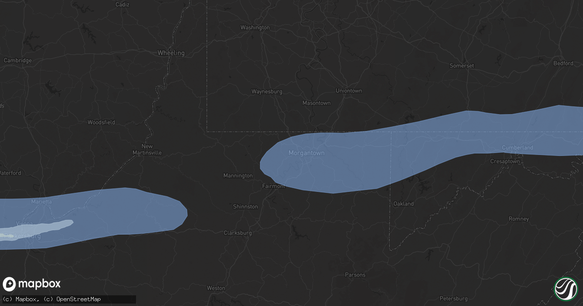
Hail Map in Morgantown, WV on April 19, 2025
Get this storm
April 19 map
$229
one time, instant access
Download today. No call, no setup
Keep the $229
Bought the map and want the full workflow? Apply the entire $229 to a subscription within 7 days. None of it is wasted.
Every map, not just this one
This buys you this map. Subscription and you get every map we run, in the markets you choose from a few cities to whole states to nationwide. Plus real-time alerts the moment a storm fires.
Contact data
Name, contact info, occupancy, even credit band for addresses in the footprint. You go from where it hit to who to call.
Become the source they trust
Unlimited branding weather history reports on demand. You already have the documented answer ready for the property owner, and you are the one who showed up with it.
Property data and RoofTrace estimates
Pull up any address you have got, its value and the exact code rules for that jurisdiction, straight from One Click Code. Then RoofTrace estimates the squares, pitch, and roof value, priced the way you price.
Storm reports in Morgantown, WV
Morgantown, WV
| Date | Description |
|---|---|
| 04/18/20257:29 PM CDT | Numerous trees down across the area. |
| 04/18/20257:29 PM CDT | Numerous trees down across the area |
| 04/18/20257:26 PM CDT | Reported at morgantown airport. |
| 04/18/20257:26 PM CDT | Building collapse and numerous trees down. |
| 04/18/20257:26 PM CDT | Corrects previous tstm wnd gst report from 2 ene morgantown. Corrected source to asos. Reported at morgantown airport |
| 04/18/20257:26 PM CDT | Building collapse and numerous trees down |
| 04/18/20257:25 PM CDT | Tree down into a structure. |
| 04/18/20257:25 PM CDT | Tree down into a structure |
| 04/18/20257:25 PM CDT | 3 trees down on separate houses. Numerous other trees reported down in the area |
| 04/18/20257:25 PM CDT | 3 trees down on separate houses. Numerous other trees reported down in the area. |
| 04/18/20257:24 PM CDT | Images shared of wind blown debris damaging home at cheat lake. Time estimated based on radar. |
| 04/18/20257:23 PM CDT | Report of a tree down along killarney drive. Time estimated based on radar. |
| 04/18/20257:23 PM CDT | Report of blown out windows and doors along with roof damage in the falling water neighborhood of cheat lake. Time estimated based on radar. |
| 04/18/20257:17 PM CDT | Report of roof damage to an apartment building along university avenue. Time estimated based on radar. |
| 04/18/20257:17 PM CDT | Trees down on cassville mt morris rd |
| 04/18/20257:17 PM CDT | Trees down on cassville mt morris rd. |
| 04/18/20257:14 PM CDT | Report of tree down on helmick road. Time estimated based on radar. |
All States Impacted by Hail Map on April 19, 2025
All Cities Impacted by Hail Map on April 19, 2025
- Tahlequah, OK
- Rose, OK
- Oaks, OK
- Twin Oaks, OK
- Kansas, OK
- Custer, MI
- Fountain, MI
- Branch, MI
- Irons, MI
- Bellevue, TX
- Bowie, TX
- Nocona, TX
- Mason, TX
- Voca, TX
- Fredonia, TX
- San Saba, TX
- Cherokee, TX
- Pontotoc, TX
- Birch Tree, MO
- Goldthwaite, TX
- Ellington, MO
- Loudonville, OH
- Lakeville, OH
- Big Prairie, OH
- Freedom, PA
- Fort Stockton, TX
- Iraan, TX
- Reynoldsville, PA
- Punxsutawney, PA
- Sykesville, PA
- Luthersburg, PA
- Stump Creek, PA
- Troutville, PA
- Rockton, PA
- Du Bois, PA
- Curwensville, PA
- Grampian, PA
- Mahaffey, PA
- Penfield, PA
- Clearfield, PA
- Frenchville, PA
- Hyde, PA
- Woodland, PA
- Mineral Springs, PA
- Bigler, PA
- West Decatur, PA
- Morrisdale, PA
- Wallaceton, PA
- Philipsburg, PA
- Ozona, TX
- Drifting, PA
- Kylertown, PA
- Allport, PA
- Winburne, PA
- Munson, PA
- Grassflat, PA
- Hawk Run, PA
- Midkiff, TX
- Lanse, PA
- Moshannon, PA
- Big Lake, TX
- McCamey, TX
- Sterling City, TX
- Bronte, TX
- Seaman, OH
- Blackwell, TX
- Winchester, OH
- Bainbridge, OH
- Hillsboro, OH
- Robert Lee, TX
- Peebles, OH
- Chillicothe, OH
- Waverly, OH
- Monongahela, PA
- Charleroi, PA
- Monessen, PA
- Donora, PA
- Belle Vernon, PA
- Maryneal, TX
- Roscoe, TX
- Sweetwater, TX
- Nolan, TX
- Piketon, OH
- Londonderry, OH
- South Bloomingville, OH
- Ray, OH
- Richmond Dale, OH
- Van Voorhis, PA
- Bentleyville, PA
- Smithton, PA
- West Newton, PA
- Mertzon, TX
- Rankin, TX
- Malta, OH
- Beverly, OH
- Mcconnelsville, OH
- Stockport, OH
- Waterford, OH
- Ovalo, TX
- Tuscola, TX
- Abilene, TX
- Moran, TX
- Breckenridge, TX
- Jacksboro, TX
- Lowell, OH
- Lawn, TX
- Winters, TX
- Baird, TX
- Clyde, TX
- Coolville, OH
- Little Hocking, OH
- Henrietta, TX
- Washington, WV
- Parkersburg, WV
- Belpre, OH
- Graysville, OH
- Woodsfield, OH
- Indiahoma, OK
- Waverly, WV
- Vienna, WV
- Garden City, TX
- Amesville, OH
- Athens, OH
- Cutler, OH
- Guysville, OH
- Fleming, OH
- Stewart, OH
- Vincent, OH
- Marietta, OH
- Williamstown, WV
- Mineral Wells, WV
- Whipple, OH
- Reno, OH
- Belmont, WV
- Newport, OH
- New Matamoras, OH
- Saint Marys, WV
- Friendly, WV
- Walker, WV
- Sistersville, WV
- Pennsboro, WV
- Harrisville, WV
- Petroleum, WV
- Cairo, WV
- Davisville, WV
- Middlebourne, WV
- Ellenboro, WV
- Alma, WV
- Hannibal, OH
- Sardis, OH
- New Martinsville, WV
- Clarington, OH
- Albany, TX
- Jacksonburg, WV
- West Union, WV
- Salem, WV
- Center Point, WV
- Chico, TX
- Sunset, TX
- Littleton, WV
- Cameron, WV
- Proctor, WV
- Glen Easton, WV
- Woodson, TX
- Wana, WV
- Burton, WV
- Aleppo, PA
- Hundred, WV
- Fairview, WV
- New Freeport, PA
- Montague, TX
- Graham, TX
- Saint Jo, TX
- Newcastle, TX
- Osage, WV
- Morgantown, WV
- Maidsville, WV
- Rivesville, WV
- Fairmont, WV
- Pursglove, WV
- Baxter, WV
- Granville, WV
- Bretz, WV
- Montana Mines, WV
- Kingwood, WV
- Reedsville, WV
- Arthurdale, WV
- Newburg, WV
- Masontown, WV
- Bruceton Mills, WV
- Albright, WV
- Independence, WV
- Gibbon Glade, PA
- Markleysburg, PA
- Farmington, PA
- Salisbury, PA
- Friendsville, MD
- Meyersdale, PA
- Terra Alta, WV
- Grantsville, MD
- Fort Hill, PA
- Addison, PA
- Accident, MD
- Confluence, PA
- Swanton, MD
- West Salisbury, PA
- McHenry, MD
- Frostburg, MD
- Oakland, MD
- Lonaconing, MD
- Boynton, PA
- Springs, PA
- Hyndman, PA
- Mount Savage, MD
- Wellersburg, PA
- Midlothian, MD
- Cumberland, MD
- Wilson, OK
- Ringling, OK
- Wingate, TX
- Merkel, TX
- Hico, TX
- Carlsbad, TX
- Overbrook, OK
- Comanche, TX
- Stephenville, TX
- Dyess Afb, TX
- Ellerslie, MD
- Corriganville, MD
- Bedford, PA
- Everett, PA
- Clearville, PA
- Flintstone, MD
- Artemas, PA
- Warfordsburg, PA
- Mercersburg, PA
- Little Orleans, MD
- Big Cove Tannery, PA
- Needmore, PA
- Berkeley Springs, WV
- Ridgeley, WV
- Oldtown, MD
- Hancock, MD
- Great Cacapon, WV
- Bluff Dale, TX
- Dublin, TX
- Tolar, TX
- Lone Grove, OK
- Burneyville, OK
- San Angelo, TX
- Tye, TX
- Coyanosa, TX
- Pecos, TX
- De Leon, TX
- Ardmore, OK
- Springer, OK
- Buffalo Gap, TX
- Granbury, TX
- Lipan, TX
- Weatherford, TX
- Loop, TX
- Seagraves, TX
- Brownfield, TX
- Crane, TX
- Imperial, TX
- Leon, OK
- Millsap, TX
- Mineral Wells, TX
- Muenster, TX
- Hagerstown, MD
- Clear Spring, MD
- Waynesboro, PA
- Greencastle, PA
- Big Pool, MD
- Hedgesville, WV
- Rouzerville, PA
- State Line, PA
- Blue Ridge Summit, PA
- Fairfield, PA
- Maugansville, MD
- Smithsburg, MD
- Cascade, MD
- Emmitsburg, MD
- Sabillasville, MD
- Gettysburg, PA
- Frederick, MD
- Boonsboro, MD
- Keymar, MD
- Falling Waters, WV
- Fairplay, MD
- Littlestown, PA
- Thurmont, MD
- Myersville, MD
- Woodsboro, MD
- Taneytown, MD
- Walkersville, MD
- Westminster, MD
- Funkstown, MD
- New Windsor, MD
- Rocky Ridge, MD
- Union Bridge, MD
- Williamsport, MD
- Hanover, PA
- New Freedom, PA
- Railroad, PA
- Glenville, PA
- Hampstead, MD
- Manchester, MD
- Freeland, MD
- Glen Rock, PA
- Finksburg, MD
- Parkton, MD
- Upperco, MD
- Sparks Glencoe, MD
- Reisterstown, MD
- Marietta, OK
- Roff, OK
- Gainesville, TX
- Ballinger, TX
- Norton, TX
- Perrin, TX
- Sulphur, OK
- Miles, TX
- Dougherty, OK
- Davis, OK
- New Park, PA
- White Hall, MD
- Shrewsbury, PA
- Stewartstown, PA
- Monkton, MD
- Ada, OK
- Thackerville, OK
- Ropesville, TX
- Wolfforth, TX
- Meadow, TX
- Santo, TX
- Konawa, OK
- Mill Creek, OK
- Tahoka, TX
- Poolville, TX
- Wilson, TX
- Lubbock, TX
- Sheffield, TX
- Dryden, TX
- Rowena, TX
- Springtown, TX
- Holdenville, OK
- Wewoka, OK
- Sasakwa, OK
- Madill, OK
- Maud, OK
- Tishomingo, OK
- Mannsville, OK
- Whitesboro, TX
- Paradise, TX
- Lebanon, OK
- Kingston, OK
- Bridgeport, TX
- Talpa, TX
- Coleman, TX
- Boynton, OK
- Council Hill, OK
- Checotah, OK
- Stonewall, OK
- Novice, TX
- Barnhart, TX
- Fitzhugh, OK
- Tupelo, OK
- Decatur, TX
- Gordonville, TX
- Centrahoma, OK
- Morris, OK
- Haskell, OK
- Mead, OK
- Burkett, TX
- Allen, OK
- Milburn, OK
- Alvord, TX
- Durant, OK
- Kenefic, OK
- Calvin, OK
- Coalgate, OK
- Calera, OK
- Coleman, OK
- Valera, TX
- Wapanucka, OK
- Caddo, OK
- Cross Plains, TX
- Brownwood, TX
- Goodfellow Afb, TX
- Vancourt, TX
- Wall, TX
- Eola, TX
- Mereta, TX
- Forestburg, TX
- Caney, OK
- Rising Star, TX
- Atoka, OK
- Ringgold, TX
- Cisco, TX
- Sonora, TX
- Santa Anna, TX
- May, TX
- Kiowa, OK
- Wardville, OK
- Paint Rock, TX
- Millersview, TX
- Eldorado, TX
- Pittsburg, OK
- Carbon, TX
- Gorman, TX
- Lane, OK
- Blanco, OK
- Eden, TX
- Goldsboro, TX
- Hartshorne, OK
- Stuart, OK
- Mcalester, OK
- Haileyville, OK
- Wilburton, OK
- Junction, TX
- Rocksprings, TX
- Menard, TX
- Bryson, TX
- Roosevelt, TX
- Melvin, TX
- Red Oak, OK
- Bangs, TX
- Monaca, PA
- Beaver, PA
- Rochester, PA
- Zelienople, PA
- Cranberry Township, PA
- Mars, PA
- Valencia, PA
- Evans City, PA
- Boyd, TX
- Lohn, TX
- Sanderson, TX
- Brackettville, TX
- Mountain Home, TX
- Leakey, TX
- Vanderpool, TX
- Hunt, TX
- Harper, TX
- Natural Dam, AR
- Medina, TX
- Farmington, AR
- Prairie Grove, AR
- Fayetteville, AR
- Pipe Creek, TX
- Bandera, TX
- Jadwin, MO
- Salem, MO


