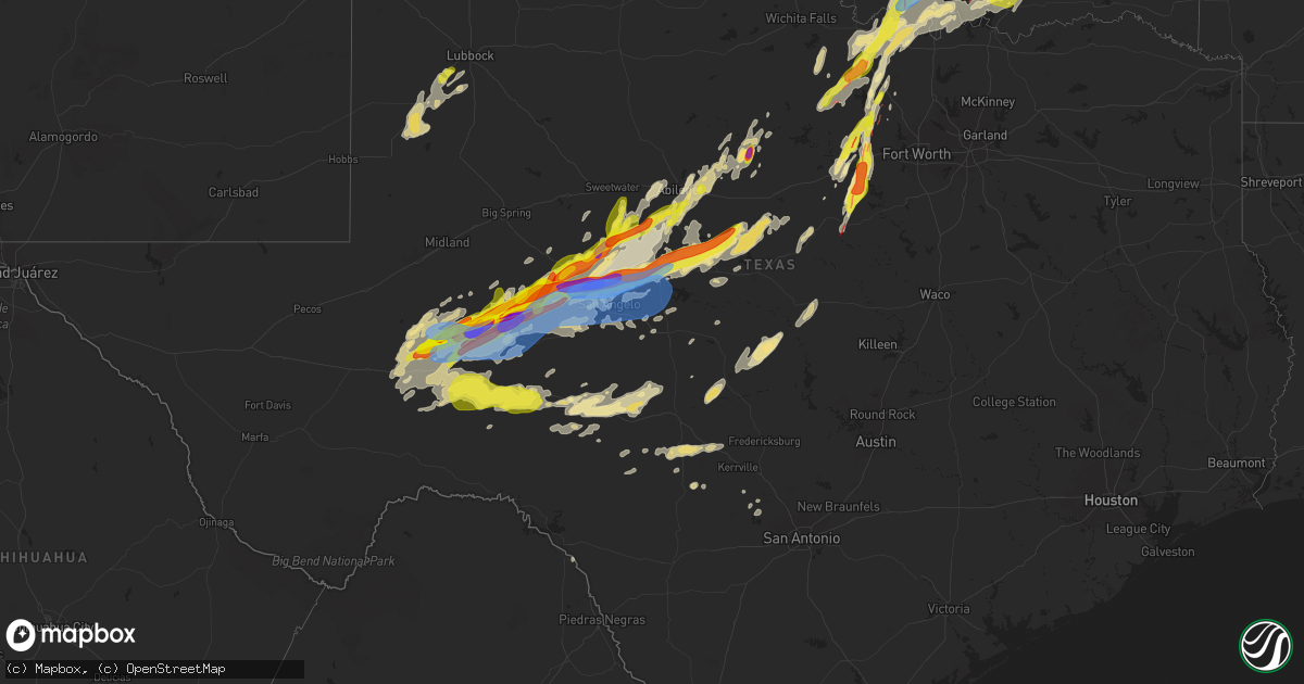
Hail Map in Texas on April 19, 2025
Get this storm
April 19 map
$229
one time, instant access
Download today. No call, no setup
Keep the $229
Bought the map and want the full workflow? Apply the entire $229 to a subscription within 7 days. None of it is wasted.
Every map, not just this one
This buys you this map. Subscription and you get every map we run, in the markets you choose from a few cities to whole states to nationwide. Plus real-time alerts the moment a storm fires.
Contact data
Name, contact info, occupancy, even credit band for addresses in the footprint. You go from where it hit to who to call.
Become the source they trust
Unlimited branding weather history reports on demand. You already have the documented answer ready for the property owner, and you are the one who showed up with it.
Property data and RoofTrace estimates
Pull up any address you have got, its value and the exact code rules for that jurisdiction, straight from One Click Code. Then RoofTrace estimates the squares, pitch, and roof value, priced the way you price.
Storm reports in Texas
Texas
| Date | Description |
|---|---|
| 04/19/20256:50 PM CDT | Quarter to half-dollar size hail at the sheriffs office in rankin. |
| 04/19/20256:32 PM CDT | Tornado reported at hwy 59 and fm 1810. |
| 04/19/20256:18 PM CDT | Media reports tornado crossing hwy 380 east of jacksboro. |
| 04/19/20256:16 PM CDT | Social media pictures of damage to a manufacturing building. Partial roof removal and damage to garage doors. Possible tornado. |
| 04/19/20256:05 PM CDT | 2 inch diameter hail reported on hubbard creek lake. |
| 04/19/20255:49 PM CDT | Law enforcement reports nickel to quarter size hail in mccamey. |
| 04/19/20255:35 PM CDT | Reported on x... Was measured at 2.25 inches. |
| 04/19/20255:35 PM CDT | 2.25 inch hail measured west of robert lee. |
| 04/19/20255:34 PM CDT | Report from mping: quarter |
| 04/19/20255:19 PM CDT | A local report indicates 2.00 inch wind near 9 E Broome |
| 04/19/20255:13 PM CDT | There was a report of very large hail damaging cars and trees. |
| 04/19/20255:10 PM CDT | Ping pong to golfball ball sized hail observed on the road from chaser footage north of big lake. |
| 04/19/20254:58 PM CDT | A local report indicates 1.00 inch wind near 1 NW Broome |
| 04/19/20254:55 PM CDT | Brief tornado touchdown. |
| 04/19/20254:48 PM CDT | Report from mping: quarter |
| 04/19/20254:46 PM CDT | In addition... There was 4 inches of rain and high winds. |
| 04/19/20254:02 PM CDT | Report from mping: hen egg |
| 04/19/20254:00 PM CDT | Large tornado confirmed by trained spotter. |
| 04/19/20253:32 PM CDT | Trained spotter reports quarter to ping pong sized hail one half mile to 3 miles south of mccamey. |
| 04/19/202511:40 AM CDT | Half dollar size hail reported in bridgeport. |
| 04/19/20255:03 AM CDT | Public report of quarter sized hail. |
| 04/19/20253:48 AM CDT | Emergency management relayed a report of tree damage near the intersection of fm 1810 and grace ranch road. Time estimated from radar. |
| 04/19/20253:32 AM CDT | Emergency management reported that the entire town of jacksboro lost power due to a downed transmission line near the intersection of highway 59 and lost creek road. |
| 04/19/202512:54 AM CDT | Facebook photos showed trees blown down and sheet metal roof blown off barn at 13324 cr 417. |
| 04/19/202512:14 AM CDT | A local report indicates 61 MPH wind near 9 NNE Christoval |
| 04/18/202511:00 PM CDT | A local report indicates 70 MPH wind near 12 N Barnhart |
| 04/18/202510:40 PM CDT | Facebook video showed hail up to golf ball size fell near millsap. |
| 04/18/202510:20 PM CDT | Multiple reports of a tornado viewed from ric williamson hwy at fm 920. |
| 04/18/202510:06 PM CDT | A local report indicates 1.25 inch wind near 5 E Ropesville |
| 04/18/202510:03 PM CDT | Parker county sheriff office observed a tornado south of i-20 at mile marker 403 moving ne. Location approximate. |
| 04/18/20259:52 PM CDT | A local report indicates 74 MPH wind near 1 S Grape Creek |
| 04/18/20259:45 PM CDT | A local report indicates 1.00 inch wind near Tennyson |
| 04/18/20259:44 PM CDT | A local report indicates 1.00 inch wind near 6 WNW Harriet |
| 04/18/20259:42 PM CDT | There was a picture on social media of the large hail. The report was from quail valley. |
| 04/18/20259:25 PM CDT | Corrects previous tstm wnd dmg report from 5 w oak trail shores. Pictures sent in from ham radio of an uprooted tree that fell on a shed. |
| 04/18/20259:21 PM CDT | A local report indicates 1.75 inch wind near 3 SE Water Valley |
| 04/18/20259:19 PM CDT | There was a picture of the large hail on social media. The large hail fell between 9 and 9:30 pm. |
| 04/18/20259:15 PM CDT | Picture of hail stone on social media. |
| 04/18/20259:05 PM CDT | Report from mping: quarter |
| 04/18/20259:05 PM CDT | Social media photos of a tornado southwest of tolar. Location approximate. |
| 04/18/20258:55 PM CDT | Report from mping: quarter |
| 04/18/20258:45 PM CDT | Substantial tree damage reported in this area. One tree down on a home. Possible tornado. |
| 04/18/20258:30 PM CDT | Tornado visible to the southwest on txdot camera located at us 67 and hwy 220. Location approximate. |
| 04/18/20258:25 PM CDT | A local report indicates 1.25 inch wind near Wingate |
| 04/18/20258:25 PM CDT | Pictures sent in from ham radio of an uprooted tree that fell on a shed. |
| 04/18/20258:25 PM CDT | Photo of tornado in progress north of hico on social media. Location approximate and based on tds on radar. |
| 04/18/20258:00 PM CDT | 3 inch hail reported 8 miles east of rankin. |
| 04/18/20257:42 PM CDT | City of bowie police department closed nelson street at mill street... Nelson street at the railroad bridge... And decatur street due to flooding. |
| 04/18/20257:03 PM CDT | Ham radio reported tornado 3 miles southwest of fruitland. |
| 04/18/20257:02 PM CDT | Media reported tornado approaching hwy 287 near fruitland. |
All States Impacted by Hail Map on April 19, 2025
Cities Impacted by Hail Map on April 19, 2025
- Tahlequah, OK
- Rose, OK
- Oaks, OK
- Twin Oaks, OK
- Kansas, OK
- Custer, MI
- Fountain, MI
- Branch, MI
- Irons, MI
- Bellevue, TX
- Bowie, TX
- Nocona, TX
- Mason, TX
- Voca, TX
- Fredonia, TX
- San Saba, TX
- Cherokee, TX
- Pontotoc, TX
- Birch Tree, MO
- Goldthwaite, TX
- Ellington, MO
- Loudonville, OH
- Lakeville, OH
- Big Prairie, OH
- Freedom, PA
- Fort Stockton, TX
- Iraan, TX
- Reynoldsville, PA
- Punxsutawney, PA
- Sykesville, PA
- Luthersburg, PA
- Stump Creek, PA
- Troutville, PA
- Rockton, PA
- Du Bois, PA
- Curwensville, PA
- Grampian, PA
- Mahaffey, PA
- Penfield, PA
- Clearfield, PA
- Frenchville, PA
- Hyde, PA
- Woodland, PA
- Mineral Springs, PA
- Bigler, PA
- West Decatur, PA
- Morrisdale, PA
- Wallaceton, PA
- Philipsburg, PA
- Ozona, TX
- Drifting, PA
- Kylertown, PA
- Allport, PA
- Winburne, PA
- Munson, PA
- Grassflat, PA
- Hawk Run, PA
- Midkiff, TX
- Lanse, PA
- Moshannon, PA
- Big Lake, TX
- McCamey, TX
- Sterling City, TX
- Bronte, TX
- Seaman, OH
- Blackwell, TX
- Winchester, OH
- Bainbridge, OH
- Hillsboro, OH
- Robert Lee, TX
- Peebles, OH
- Chillicothe, OH
- Waverly, OH
- Monongahela, PA
- Charleroi, PA
- Monessen, PA
- Donora, PA
- Belle Vernon, PA
- Maryneal, TX
- Roscoe, TX
- Sweetwater, TX
- Nolan, TX
- Piketon, OH
- Londonderry, OH
- South Bloomingville, OH
- Ray, OH
- Richmond Dale, OH
- Van Voorhis, PA
- Bentleyville, PA
- Smithton, PA
- West Newton, PA
- Mertzon, TX
- Rankin, TX
- Malta, OH
- Beverly, OH
- Mcconnelsville, OH
- Stockport, OH
- Waterford, OH
- Ovalo, TX
- Tuscola, TX
- Abilene, TX
- Moran, TX
- Breckenridge, TX
- Jacksboro, TX
- Lowell, OH
- Lawn, TX
- Winters, TX
- Baird, TX
- Clyde, TX
- Coolville, OH
- Little Hocking, OH
- Henrietta, TX
- Washington, WV
- Parkersburg, WV
- Belpre, OH
- Graysville, OH
- Woodsfield, OH
- Indiahoma, OK
- Waverly, WV
- Vienna, WV
- Garden City, TX
- Amesville, OH
- Athens, OH
- Cutler, OH
- Guysville, OH
- Fleming, OH
- Stewart, OH
- Vincent, OH
- Marietta, OH
- Williamstown, WV
- Mineral Wells, WV
- Whipple, OH
- Reno, OH
- Belmont, WV
- Newport, OH
- New Matamoras, OH
- Saint Marys, WV
- Friendly, WV
- Walker, WV
- Sistersville, WV
- Pennsboro, WV
- Harrisville, WV
- Petroleum, WV
- Cairo, WV
- Davisville, WV
- Middlebourne, WV
- Ellenboro, WV
- Alma, WV
- Hannibal, OH
- Sardis, OH
- New Martinsville, WV
- Clarington, OH
- Albany, TX
- Jacksonburg, WV
- West Union, WV
- Salem, WV
- Center Point, WV
- Chico, TX
- Sunset, TX
- Littleton, WV
- Cameron, WV
- Proctor, WV
- Glen Easton, WV
- Woodson, TX
- Wana, WV
- Burton, WV
- Aleppo, PA
- Hundred, WV
- Fairview, WV
- New Freeport, PA
- Montague, TX
- Graham, TX
- Saint Jo, TX
- Newcastle, TX
- Osage, WV
- Morgantown, WV
- Maidsville, WV
- Rivesville, WV
- Fairmont, WV
- Pursglove, WV
- Baxter, WV
- Granville, WV
- Bretz, WV
- Montana Mines, WV
- Kingwood, WV
- Reedsville, WV
- Arthurdale, WV
- Newburg, WV
- Masontown, WV
- Bruceton Mills, WV
- Albright, WV
- Independence, WV
- Gibbon Glade, PA
- Markleysburg, PA
- Farmington, PA
- Salisbury, PA
- Friendsville, MD
- Meyersdale, PA
- Terra Alta, WV
- Grantsville, MD
- Fort Hill, PA
- Addison, PA
- Accident, MD
- Confluence, PA
- Swanton, MD
- West Salisbury, PA
- McHenry, MD
- Frostburg, MD
- Oakland, MD
- Lonaconing, MD
- Boynton, PA
- Springs, PA
- Hyndman, PA
- Mount Savage, MD
- Wellersburg, PA
- Midlothian, MD
- Cumberland, MD
- Wilson, OK
- Ringling, OK
- Wingate, TX
- Merkel, TX
- Hico, TX
- Carlsbad, TX
- Overbrook, OK
- Comanche, TX
- Stephenville, TX
- Dyess Afb, TX
- Ellerslie, MD
- Corriganville, MD
- Bedford, PA
- Everett, PA
- Clearville, PA
- Flintstone, MD
- Artemas, PA
- Warfordsburg, PA
- Mercersburg, PA
- Little Orleans, MD
- Big Cove Tannery, PA
- Needmore, PA
- Berkeley Springs, WV
- Ridgeley, WV
- Oldtown, MD
- Hancock, MD
- Great Cacapon, WV
- Bluff Dale, TX
- Dublin, TX
- Tolar, TX
- Lone Grove, OK
- Burneyville, OK
- San Angelo, TX
- Tye, TX
- Coyanosa, TX
- Pecos, TX
- De Leon, TX
- Ardmore, OK
- Springer, OK
- Buffalo Gap, TX
- Granbury, TX
- Lipan, TX
- Weatherford, TX
- Loop, TX
- Seagraves, TX
- Brownfield, TX
- Crane, TX
- Imperial, TX
- Leon, OK
- Millsap, TX
- Mineral Wells, TX
- Muenster, TX
- Hagerstown, MD
- Clear Spring, MD
- Waynesboro, PA
- Greencastle, PA
- Big Pool, MD
- Hedgesville, WV
- Rouzerville, PA
- State Line, PA
- Blue Ridge Summit, PA
- Fairfield, PA
- Maugansville, MD
- Smithsburg, MD
- Cascade, MD
- Emmitsburg, MD
- Sabillasville, MD
- Gettysburg, PA
- Frederick, MD
- Boonsboro, MD
- Keymar, MD
- Falling Waters, WV
- Fairplay, MD
- Littlestown, PA
- Thurmont, MD
- Myersville, MD
- Woodsboro, MD
- Taneytown, MD
- Walkersville, MD
- Westminster, MD
- Funkstown, MD
- New Windsor, MD
- Rocky Ridge, MD
- Union Bridge, MD
- Williamsport, MD
- Hanover, PA
- New Freedom, PA
- Railroad, PA
- Glenville, PA
- Hampstead, MD
- Manchester, MD
- Freeland, MD
- Glen Rock, PA
- Finksburg, MD
- Parkton, MD
- Upperco, MD
- Sparks Glencoe, MD
- Reisterstown, MD
- Marietta, OK
- Roff, OK
- Gainesville, TX
- Ballinger, TX
- Norton, TX
- Perrin, TX
- Sulphur, OK
- Miles, TX
- Dougherty, OK
- Davis, OK
- New Park, PA
- White Hall, MD
- Shrewsbury, PA
- Stewartstown, PA
- Monkton, MD
- Ada, OK
- Thackerville, OK
- Ropesville, TX
- Wolfforth, TX
- Meadow, TX
- Santo, TX
- Konawa, OK
- Mill Creek, OK
- Tahoka, TX
- Poolville, TX
- Wilson, TX
- Lubbock, TX
- Sheffield, TX
- Dryden, TX
- Rowena, TX
- Springtown, TX
- Holdenville, OK
- Wewoka, OK
- Sasakwa, OK
- Madill, OK
- Maud, OK
- Tishomingo, OK
- Mannsville, OK
- Whitesboro, TX
- Paradise, TX
- Lebanon, OK
- Kingston, OK
- Bridgeport, TX
- Talpa, TX
- Coleman, TX
- Boynton, OK
- Council Hill, OK
- Checotah, OK
- Stonewall, OK
- Novice, TX
- Barnhart, TX
- Fitzhugh, OK
- Tupelo, OK
- Decatur, TX
- Gordonville, TX
- Centrahoma, OK
- Morris, OK
- Haskell, OK
- Mead, OK
- Burkett, TX
- Allen, OK
- Milburn, OK
- Alvord, TX
- Durant, OK
- Kenefic, OK
- Calvin, OK
- Coalgate, OK
- Calera, OK
- Coleman, OK
- Valera, TX
- Wapanucka, OK
- Caddo, OK
- Cross Plains, TX
- Brownwood, TX
- Goodfellow Afb, TX
- Vancourt, TX
- Wall, TX
- Eola, TX
- Mereta, TX
- Forestburg, TX
- Caney, OK
- Rising Star, TX
- Atoka, OK
- Ringgold, TX
- Cisco, TX
- Sonora, TX
- Santa Anna, TX
- May, TX
- Kiowa, OK
- Wardville, OK
- Paint Rock, TX
- Millersview, TX
- Eldorado, TX
- Pittsburg, OK
- Carbon, TX
- Gorman, TX
- Lane, OK
- Blanco, OK
- Eden, TX
- Goldsboro, TX
- Hartshorne, OK
- Stuart, OK
- Mcalester, OK
- Haileyville, OK
- Wilburton, OK
- Junction, TX
- Rocksprings, TX
- Menard, TX
- Bryson, TX
- Roosevelt, TX
- Melvin, TX
- Red Oak, OK
- Bangs, TX
- Monaca, PA
- Beaver, PA
- Rochester, PA
- Zelienople, PA
- Cranberry Township, PA
- Mars, PA
- Valencia, PA
- Evans City, PA
- Boyd, TX
- Lohn, TX
- Sanderson, TX
- Brackettville, TX
- Mountain Home, TX
- Leakey, TX
- Vanderpool, TX
- Hunt, TX
- Harper, TX
- Natural Dam, AR
- Medina, TX
- Farmington, AR
- Prairie Grove, AR
- Fayetteville, AR
- Pipe Creek, TX
- Bandera, TX
- Jadwin, MO
- Salem, MO


