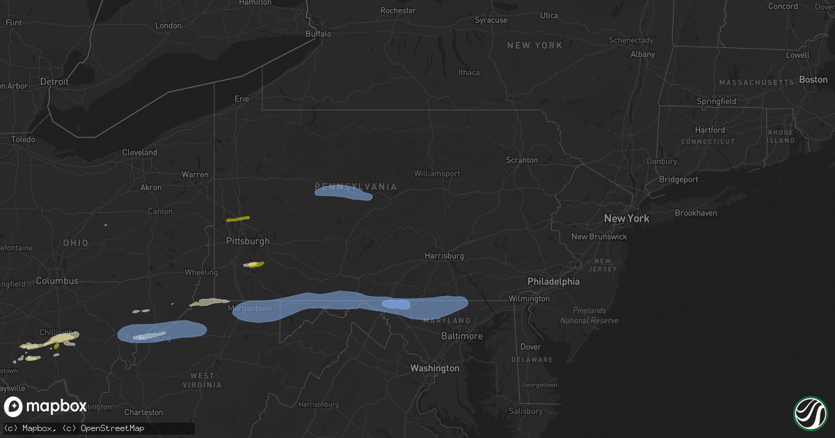
Hail Map in Pennsylvania on April 19, 2025
Get this storm
April 19 map
$229
one time, instant access
Download today. No call, no setup
Keep the $229
Bought the map and want the full workflow? Apply the entire $229 to a subscription within 7 days. None of it is wasted.
Every map, not just this one
This buys you this map. Subscription and you get every map we run, in the markets you choose from a few cities to whole states to nationwide. Plus real-time alerts the moment a storm fires.
Contact data
Name, contact info, occupancy, even credit band for addresses in the footprint. You go from where it hit to who to call.
Become the source they trust
Unlimited branding weather history reports on demand. You already have the documented answer ready for the property owner, and you are the one who showed up with it.
Property data and RoofTrace estimates
Pull up any address you have got, its value and the exact code rules for that jurisdiction, straight from One Click Code. Then RoofTrace estimates the squares, pitch, and roof value, priced the way you price.
Storm reports in Pennsylvania
Pennsylvania
| Date | Description |
|---|---|
| 04/19/20255:55 PM CDT | Trees and wires down. |
| 04/19/20255:55 PM CDT | Trees and wires down |
| 04/19/20255:45 PM CDT | A power pole was brought down over finley road. |
| 04/19/20255:43 PM CDT | A local report indicates 1.00 inch wind near Charleroi |
| 04/19/20255:33 PM CDT | Two trees down |
| 04/19/20255:33 PM CDT | Two trees down. |
| 04/19/20255:16 PM CDT | This gust was measured by a btmeter handheld anemometer. |
| 04/19/20254:05 PM CDT | Several reports of trees and wires down in the area. |
| 04/19/20253:50 PM CDT | Multiple trees down along washington ave. Relayed via nws albany. |
| 04/19/20253:50 PM CDT | Trees down... Blocking roadway. |
| 04/19/20253:45 PM CDT | Several trees and wires down in the area. |
| 04/19/20253:30 PM CDT | Trees and wires down in the area. |
| 04/19/20253:15 PM CDT | Tree down on wires. |
| 04/19/20253:11 PM CDT | Tree down on roadway. |
| 04/19/20253:04 PM CDT | Tree down. |
| 04/19/20252:00 PM CDT | Rwis roadway sensor at clearfield-shawville sr879/ exit #120 of interstate 80. |
| 04/19/20251:54 PM CDT | Numerous trees and wires down in clearfield proper. |
| 04/19/20251:53 PM CDT | Numerous trees and wires down between hyde and clearfield. |
| 04/19/20251:05 PM CDT | A local report indicates 1.00 inch wind near 1 NNW Mars |
| 04/19/202512:50 PM CDT | Report of a lot of trees and wires down in the summit township area. Time estimated based on radar. |
| 04/19/202512:48 PM CDT | A tree fell down on private property. |
| 04/19/202512:46 PM CDT | Trees down. |
| 04/19/202512:46 PM CDT | Trees down |
| 04/19/202512:45 PM CDT | Report of multiple trees down along route 8 near succop nature reserve. Time estimated based on radar. |
| 04/19/202512:45 PM CDT | Public report with pictures of trees down near country club heights lane in penn township. Time estimated based on radar. |
| 04/19/202512:44 PM CDT | Report of trees down along larchwood drive near route 8. Time estimated based on radar. |
| 04/19/202512:37 PM CDT | Em reported a few trees down including one on power lines. |
| 04/18/20259:28 PM CDT | Several trees down on power lines and blocking the road near the intersection of bankard road and kreidlers schoolhouse road... Northeast along pleasant hill road. |
| 04/18/20259:25 PM CDT | Tree down on a house. |
| 04/18/20259:00 PM CDT | Multiple trees and wires down in waynesboro. |
| 04/18/20258:59 PM CDT | Multiple trees down. |
| 04/18/20258:59 PM CDT | Awning collapsed at state line united methodist church in state line. |
| 04/18/20258:58 PM CDT | Trees and wires down in greencastle. |
| 04/18/20258:50 PM CDT | Damage to powerlines throughout mercersburg. |
| 04/18/20258:49 PM CDT | Multiple trees down. |
| 04/18/20258:39 PM CDT | Trees/wires down. |
| 04/18/20258:38 PM CDT | A tree fell onto a car in belfast township. |
| 04/18/20258:21 PM CDT | Wires down in southampton township. |
| 04/18/20258:12 PM CDT | Multiple trees down on roadway. |
| 04/18/20257:57 PM CDT | Emergency management reports a silo collapsed into a barn... The barn collapsed. |
| 04/18/20257:46 PM CDT | Tree down onto house... Through roof... No injuries. |
| 04/18/20257:24 PM CDT | Trees down. |
| 04/18/20257:24 PM CDT | Trees down |
| 04/18/20257:15 PM CDT | Report of a tree across state route 2021 in dunkard township. Time estimated based on radar. |
All States Impacted by Hail Map on April 19, 2025
Cities Impacted by Hail Map on April 19, 2025
- Tahlequah, OK
- Rose, OK
- Oaks, OK
- Twin Oaks, OK
- Kansas, OK
- Custer, MI
- Fountain, MI
- Branch, MI
- Irons, MI
- Bellevue, TX
- Bowie, TX
- Nocona, TX
- Mason, TX
- Voca, TX
- Fredonia, TX
- San Saba, TX
- Cherokee, TX
- Pontotoc, TX
- Birch Tree, MO
- Goldthwaite, TX
- Ellington, MO
- Loudonville, OH
- Lakeville, OH
- Big Prairie, OH
- Freedom, PA
- Fort Stockton, TX
- Iraan, TX
- Reynoldsville, PA
- Punxsutawney, PA
- Sykesville, PA
- Luthersburg, PA
- Stump Creek, PA
- Troutville, PA
- Rockton, PA
- Du Bois, PA
- Curwensville, PA
- Grampian, PA
- Mahaffey, PA
- Penfield, PA
- Clearfield, PA
- Frenchville, PA
- Hyde, PA
- Woodland, PA
- Mineral Springs, PA
- Bigler, PA
- West Decatur, PA
- Morrisdale, PA
- Wallaceton, PA
- Philipsburg, PA
- Ozona, TX
- Drifting, PA
- Kylertown, PA
- Allport, PA
- Winburne, PA
- Munson, PA
- Grassflat, PA
- Hawk Run, PA
- Midkiff, TX
- Lanse, PA
- Moshannon, PA
- Big Lake, TX
- McCamey, TX
- Sterling City, TX
- Bronte, TX
- Seaman, OH
- Blackwell, TX
- Winchester, OH
- Bainbridge, OH
- Hillsboro, OH
- Robert Lee, TX
- Peebles, OH
- Chillicothe, OH
- Waverly, OH
- Monongahela, PA
- Charleroi, PA
- Monessen, PA
- Donora, PA
- Belle Vernon, PA
- Maryneal, TX
- Roscoe, TX
- Sweetwater, TX
- Nolan, TX
- Piketon, OH
- Londonderry, OH
- South Bloomingville, OH
- Ray, OH
- Richmond Dale, OH
- Van Voorhis, PA
- Bentleyville, PA
- Smithton, PA
- West Newton, PA
- Mertzon, TX
- Rankin, TX
- Malta, OH
- Beverly, OH
- Mcconnelsville, OH
- Stockport, OH
- Waterford, OH
- Ovalo, TX
- Tuscola, TX
- Abilene, TX
- Moran, TX
- Breckenridge, TX
- Jacksboro, TX
- Lowell, OH
- Lawn, TX
- Winters, TX
- Baird, TX
- Clyde, TX
- Coolville, OH
- Little Hocking, OH
- Henrietta, TX
- Washington, WV
- Parkersburg, WV
- Belpre, OH
- Graysville, OH
- Woodsfield, OH
- Indiahoma, OK
- Waverly, WV
- Vienna, WV
- Garden City, TX
- Amesville, OH
- Athens, OH
- Cutler, OH
- Guysville, OH
- Fleming, OH
- Stewart, OH
- Vincent, OH
- Marietta, OH
- Williamstown, WV
- Mineral Wells, WV
- Whipple, OH
- Reno, OH
- Belmont, WV
- Newport, OH
- New Matamoras, OH
- Saint Marys, WV
- Friendly, WV
- Walker, WV
- Sistersville, WV
- Pennsboro, WV
- Harrisville, WV
- Petroleum, WV
- Cairo, WV
- Davisville, WV
- Middlebourne, WV
- Ellenboro, WV
- Alma, WV
- Hannibal, OH
- Sardis, OH
- New Martinsville, WV
- Clarington, OH
- Albany, TX
- Jacksonburg, WV
- West Union, WV
- Salem, WV
- Center Point, WV
- Chico, TX
- Sunset, TX
- Littleton, WV
- Cameron, WV
- Proctor, WV
- Glen Easton, WV
- Woodson, TX
- Wana, WV
- Burton, WV
- Aleppo, PA
- Hundred, WV
- Fairview, WV
- New Freeport, PA
- Montague, TX
- Graham, TX
- Saint Jo, TX
- Newcastle, TX
- Osage, WV
- Morgantown, WV
- Maidsville, WV
- Rivesville, WV
- Fairmont, WV
- Pursglove, WV
- Baxter, WV
- Granville, WV
- Bretz, WV
- Montana Mines, WV
- Kingwood, WV
- Reedsville, WV
- Arthurdale, WV
- Newburg, WV
- Masontown, WV
- Bruceton Mills, WV
- Albright, WV
- Independence, WV
- Gibbon Glade, PA
- Markleysburg, PA
- Farmington, PA
- Salisbury, PA
- Friendsville, MD
- Meyersdale, PA
- Terra Alta, WV
- Grantsville, MD
- Fort Hill, PA
- Addison, PA
- Accident, MD
- Confluence, PA
- Swanton, MD
- West Salisbury, PA
- McHenry, MD
- Frostburg, MD
- Oakland, MD
- Lonaconing, MD
- Boynton, PA
- Springs, PA
- Hyndman, PA
- Mount Savage, MD
- Wellersburg, PA
- Midlothian, MD
- Cumberland, MD
- Wilson, OK
- Ringling, OK
- Wingate, TX
- Merkel, TX
- Hico, TX
- Carlsbad, TX
- Overbrook, OK
- Comanche, TX
- Stephenville, TX
- Dyess Afb, TX
- Ellerslie, MD
- Corriganville, MD
- Bedford, PA
- Everett, PA
- Clearville, PA
- Flintstone, MD
- Artemas, PA
- Warfordsburg, PA
- Mercersburg, PA
- Little Orleans, MD
- Big Cove Tannery, PA
- Needmore, PA
- Berkeley Springs, WV
- Ridgeley, WV
- Oldtown, MD
- Hancock, MD
- Great Cacapon, WV
- Bluff Dale, TX
- Dublin, TX
- Tolar, TX
- Lone Grove, OK
- Burneyville, OK
- San Angelo, TX
- Tye, TX
- Coyanosa, TX
- Pecos, TX
- De Leon, TX
- Ardmore, OK
- Springer, OK
- Buffalo Gap, TX
- Granbury, TX
- Lipan, TX
- Weatherford, TX
- Loop, TX
- Seagraves, TX
- Brownfield, TX
- Crane, TX
- Imperial, TX
- Leon, OK
- Millsap, TX
- Mineral Wells, TX
- Muenster, TX
- Hagerstown, MD
- Clear Spring, MD
- Waynesboro, PA
- Greencastle, PA
- Big Pool, MD
- Hedgesville, WV
- Rouzerville, PA
- State Line, PA
- Blue Ridge Summit, PA
- Fairfield, PA
- Maugansville, MD
- Smithsburg, MD
- Cascade, MD
- Emmitsburg, MD
- Sabillasville, MD
- Gettysburg, PA
- Frederick, MD
- Boonsboro, MD
- Keymar, MD
- Falling Waters, WV
- Fairplay, MD
- Littlestown, PA
- Thurmont, MD
- Myersville, MD
- Woodsboro, MD
- Taneytown, MD
- Walkersville, MD
- Westminster, MD
- Funkstown, MD
- New Windsor, MD
- Rocky Ridge, MD
- Union Bridge, MD
- Williamsport, MD
- Hanover, PA
- New Freedom, PA
- Railroad, PA
- Glenville, PA
- Hampstead, MD
- Manchester, MD
- Freeland, MD
- Glen Rock, PA
- Finksburg, MD
- Parkton, MD
- Upperco, MD
- Sparks Glencoe, MD
- Reisterstown, MD
- Marietta, OK
- Roff, OK
- Gainesville, TX
- Ballinger, TX
- Norton, TX
- Perrin, TX
- Sulphur, OK
- Miles, TX
- Dougherty, OK
- Davis, OK
- New Park, PA
- White Hall, MD
- Shrewsbury, PA
- Stewartstown, PA
- Monkton, MD
- Ada, OK
- Thackerville, OK
- Ropesville, TX
- Wolfforth, TX
- Meadow, TX
- Santo, TX
- Konawa, OK
- Mill Creek, OK
- Tahoka, TX
- Poolville, TX
- Wilson, TX
- Lubbock, TX
- Sheffield, TX
- Dryden, TX
- Rowena, TX
- Springtown, TX
- Holdenville, OK
- Wewoka, OK
- Sasakwa, OK
- Madill, OK
- Maud, OK
- Tishomingo, OK
- Mannsville, OK
- Whitesboro, TX
- Paradise, TX
- Lebanon, OK
- Kingston, OK
- Bridgeport, TX
- Talpa, TX
- Coleman, TX
- Boynton, OK
- Council Hill, OK
- Checotah, OK
- Stonewall, OK
- Novice, TX
- Barnhart, TX
- Fitzhugh, OK
- Tupelo, OK
- Decatur, TX
- Gordonville, TX
- Centrahoma, OK
- Morris, OK
- Haskell, OK
- Mead, OK
- Burkett, TX
- Allen, OK
- Milburn, OK
- Alvord, TX
- Durant, OK
- Kenefic, OK
- Calvin, OK
- Coalgate, OK
- Calera, OK
- Coleman, OK
- Valera, TX
- Wapanucka, OK
- Caddo, OK
- Cross Plains, TX
- Brownwood, TX
- Goodfellow Afb, TX
- Vancourt, TX
- Wall, TX
- Eola, TX
- Mereta, TX
- Forestburg, TX
- Caney, OK
- Rising Star, TX
- Atoka, OK
- Ringgold, TX
- Cisco, TX
- Sonora, TX
- Santa Anna, TX
- May, TX
- Kiowa, OK
- Wardville, OK
- Paint Rock, TX
- Millersview, TX
- Eldorado, TX
- Pittsburg, OK
- Carbon, TX
- Gorman, TX
- Lane, OK
- Blanco, OK
- Eden, TX
- Goldsboro, TX
- Hartshorne, OK
- Stuart, OK
- Mcalester, OK
- Haileyville, OK
- Wilburton, OK
- Junction, TX
- Rocksprings, TX
- Menard, TX
- Bryson, TX
- Roosevelt, TX
- Melvin, TX
- Red Oak, OK
- Bangs, TX
- Monaca, PA
- Beaver, PA
- Rochester, PA
- Zelienople, PA
- Cranberry Township, PA
- Mars, PA
- Valencia, PA
- Evans City, PA
- Boyd, TX
- Lohn, TX
- Sanderson, TX
- Brackettville, TX
- Mountain Home, TX
- Leakey, TX
- Vanderpool, TX
- Hunt, TX
- Harper, TX
- Natural Dam, AR
- Medina, TX
- Farmington, AR
- Prairie Grove, AR
- Fayetteville, AR
- Pipe Creek, TX
- Bandera, TX
- Jadwin, MO
- Salem, MO


