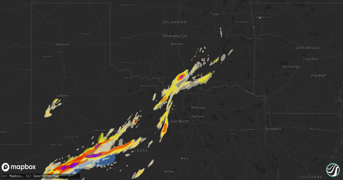
Hail Map on April 19, 2025
Get this storm
April 19 map
$229
one time, instant access
Download today. No call, no setup
Keep the $229
Bought the map and want the full workflow? Apply the entire $229 to a subscription within 7 days. None of it is wasted.
Every map, not just this one
This buys you this map. Subscription and you get every map we run, in the markets you choose from a few cities to whole states to nationwide. Plus real-time alerts the moment a storm fires.
Contact data
Name, contact info, occupancy, even credit band for addresses in the footprint. You go from where it hit to who to call.
Become the source they trust
Unlimited branding weather history reports on demand. You already have the documented answer ready for the property owner, and you are the one who showed up with it.
Property data and RoofTrace estimates
Pull up any address you have got, its value and the exact code rules for that jurisdiction, straight from One Click Code. Then RoofTrace estimates the squares, pitch, and roof value, priced the way you price.
States Impacted by Hail Map on April 19, 2025
Storm reports
Missouri
| Date | Description |
|---|---|
| 04/19/20255:00 AM CDT | Delayed report of tree down at maple and pine street. |
| 04/19/20255:00 AM CDT | Delayed report of tree down through roof of house. |
| 04/19/20254:58 AM CDT | A local report indicates 1.00 inch wind near 2 NW Salem |
Oklahoma
| Date | Description |
|---|---|
| 04/19/202512:29 AM CDT | Report from mping: quarter |
| 04/18/202511:50 PM CDT | Large tree down northwest of pierce along i-40. |
| 04/18/202511:33 PM CDT | A local report indicates 1.25 inch wind near 3 W Durant |
| 04/18/202511:12 PM CDT | Trees and power poles damaged along stallings road and decker road s of emet and northwest of nida. Likely tornado. |
| 04/18/202510:05 PM CDT | Tds noted on ktlx. |
| 04/18/20259:30 PM CDT | West side of ardmore on i-35. |
| 04/18/20259:26 PM CDT | A local report indicates 2.00 inch wind near Lone Grove |
| 04/18/20259:19 PM CDT | Report from mping: quarter |
| 04/18/20259:07 PM CDT | A local report indicates 1.75 inch wind near 4 S Lone Grove |
| 04/18/20259:05 PM CDT | Powerlines down... Sheds and barns damaged on belleville road in courtney. |
| 04/18/20258:44 PM CDT | Tornado reported by a trained spotter near oswalt road and sh 76. |
| 04/18/20258:25 PM CDT | Corrects time for previous tornado report from courtney. Powerlines down... Sheds and barns damaged on belleville road in courtney. |
Pennsylvania
| Date | Description |
|---|---|
| 04/19/20255:55 PM CDT | Trees and wires down |
| 04/19/20255:55 PM CDT | Trees and wires down. |
| 04/19/20255:45 PM CDT | A power pole was brought down over finley road. |
| 04/19/20255:43 PM CDT | A local report indicates 1.00 inch wind near Charleroi |
| 04/19/20255:33 PM CDT | Two trees down |
| 04/19/20255:33 PM CDT | Two trees down. |
| 04/19/20255:16 PM CDT | This gust was measured by a btmeter handheld anemometer. |
| 04/19/20254:05 PM CDT | Several reports of trees and wires down in the area. |
| 04/19/20253:50 PM CDT | Multiple trees down along washington ave. Relayed via nws albany. |
| 04/19/20253:50 PM CDT | Trees down... Blocking roadway. |
| 04/19/20253:45 PM CDT | Several trees and wires down in the area. |
| 04/19/20253:30 PM CDT | Trees and wires down in the area. |
| 04/19/20253:15 PM CDT | Tree down on wires. |
| 04/19/20253:11 PM CDT | Tree down on roadway. |
| 04/19/20253:04 PM CDT | Tree down. |
| 04/19/20252:00 PM CDT | Rwis roadway sensor at clearfield-shawville sr879/ exit #120 of interstate 80. |
| 04/19/20251:54 PM CDT | Numerous trees and wires down in clearfield proper. |
| 04/19/20251:53 PM CDT | Numerous trees and wires down between hyde and clearfield. |
| 04/19/20251:05 PM CDT | A local report indicates 1.00 inch wind near 1 NNW Mars |
| 04/19/202512:50 PM CDT | Report of a lot of trees and wires down in the summit township area. Time estimated based on radar. |
| 04/19/202512:48 PM CDT | A tree fell down on private property. |
| 04/19/202512:46 PM CDT | Trees down |
| 04/19/202512:46 PM CDT | Trees down. |
| 04/19/202512:45 PM CDT | Report of multiple trees down along route 8 near succop nature reserve. Time estimated based on radar. |
| 04/19/202512:45 PM CDT | Public report with pictures of trees down near country club heights lane in penn township. Time estimated based on radar. |
| 04/19/202512:44 PM CDT | Report of trees down along larchwood drive near route 8. Time estimated based on radar. |
| 04/19/202512:37 PM CDT | Em reported a few trees down including one on power lines. |
| 04/18/20259:28 PM CDT | Several trees down on power lines and blocking the road near the intersection of bankard road and kreidlers schoolhouse road... Northeast along pleasant hill road. |
| 04/18/20259:25 PM CDT | Tree down on a house. |
| 04/18/20259:00 PM CDT | Multiple trees and wires down in waynesboro. |
| 04/18/20258:59 PM CDT | Awning collapsed at state line united methodist church in state line. |
| 04/18/20258:59 PM CDT | Multiple trees down. |
| 04/18/20258:58 PM CDT | Trees and wires down in greencastle. |
| 04/18/20258:50 PM CDT | Damage to powerlines throughout mercersburg. |
| 04/18/20258:49 PM CDT | Multiple trees down. |
| 04/18/20258:39 PM CDT | Trees/wires down. |
| 04/18/20258:38 PM CDT | A tree fell onto a car in belfast township. |
| 04/18/20258:21 PM CDT | Wires down in southampton township. |
| 04/18/20258:12 PM CDT | Multiple trees down on roadway. |
| 04/18/20257:57 PM CDT | Emergency management reports a silo collapsed into a barn... The barn collapsed. |
| 04/18/20257:46 PM CDT | Tree down onto house... Through roof... No injuries. |
| 04/18/20257:24 PM CDT | Trees down. |
| 04/18/20257:24 PM CDT | Trees down |
| 04/18/20257:15 PM CDT | Report of a tree across state route 2021 in dunkard township. Time estimated based on radar. |
Maryland
| Date | Description |
|---|---|
| 04/19/20251:35 PM CDT | At least six trees down on md-30 near manchester blocking the road. |
| 04/18/202510:05 PM CDT | Numerous trees blew down near rising sun... Including on us-1 conowingo road at md-276 jacob tome memorial highway. |
| 04/18/20259:58 PM CDT | Numerous trees blew down along little road. |
| 04/18/20259:57 PM CDT | Numerous trees blew down along mill green road. |
| 04/18/20259:57 PM CDT | Numerous trees blew down along mcnabb road. |
| 04/18/20259:56 PM CDT | Numerous trees blew down along delp road. |
| 04/18/20259:56 PM CDT | Numerous trees blew down along md-646 prospect road. |
| 04/18/20259:55 PM CDT | Numerous trees blew down on ridge road. |
| 04/18/20259:54 PM CDT | Reports of a number of trees and power lines down across street... Md. |
| 04/18/20259:54 PM CDT | Numerous trees blew down along grier nursery road. |
| 04/18/20259:45 PM CDT | Numerous reports of trees down in the northern portion of baltimore county. Some on cars and structures. Area near prettyboy reservoir has the most widespread damage. L |
| 04/18/20259:43 PM CDT | Reports of a number of trees and power lines down across white hall... Md |
| 04/18/20259:42 PM CDT | Numerous trees blew down near bentley springs... Including on md-45 york road at bee tree mill court. |
| 04/18/20259:41 PM CDT | Numerous trees blew down near bentley springs... Including on md-42 york road at bentley road. |
| 04/18/20259:38 PM CDT | A local report indicates 61 MPH wind near 4 NE Millers |
| 04/18/20259:35 PM CDT | At least six trees down on md-30 near manchester blocking the road. Corrected time. |
| 04/18/20259:32 PM CDT | Numerous trees blew down near manchester... Including on md-30 main street at michelle road. |
| 04/18/20259:28 PM CDT | Awos at carroll county regional airport |
| 04/18/20259:28 PM CDT | Awos at carroll county regional airport |
| 04/18/20259:24 PM CDT | Numerous trees blew down around uniontown... Including on md-832 old taneytown road at mayberry road. |
| 04/18/20259:24 PM CDT | Numerous trees blew down near linwood... Including on md-84 union bridge road at md-75 green valley road. |
| 04/18/20259:21 PM CDT | Reports of damage to a shed that was tossed in the thunderstorm winds. Also multiple reports of tree damage across northern carroll county. |
| 04/18/20259:21 PM CDT | Reports of damage to a shed that was tossed in the thunderstorm winds |
| 04/18/20259:15 PM CDT | Cwop station dw1771 |
| 04/18/20259:12 PM CDT | Maryland mesonet station thurmont 1 ne |
| 04/18/20259:12 PM CDT | Awos at camp david |
| 04/18/20259:12 PM CDT | Numerous tree limbs blew down between thurmont and new midway. |
| 04/18/20259:10 PM CDT | Numerous trees blew down near thurmont... Including on md-550 jimtown road east of us-15. |
| 04/18/20259:10 PM CDT | Numerous tree limbs blew down southeast of thurmont. |
| 04/18/20259:09 PM CDT | Mddot sensor md 64 at md 418 |
| 04/18/20259:06 PM CDT | Numerous trees blew down near smithsburg... Including on md-77 foxville road at herman hauver road. |
| 04/18/20259:05 PM CDT | Cwop station cw1323 |
| 04/18/20259:04 PM CDT | Measured on personal weather station |
| 04/18/20259:04 PM CDT | Personal weather station kmdhager64 |
| 04/18/20259:01 PM CDT | Over a dozen trees down in thurmont to emmitsburg. Numerous roads closed. |
| 04/18/20259:01 PM CDT | At least a dozen trees down across hagerstown. |
| 04/18/20259:00 PM CDT | Extensive damage from hagerstown to smithsburg including numerous trees down... Roof damage... Shed destroyed |
| 04/18/20259:00 PM CDT | A local report indicates 75 MPH wind near Hagerstown Rgnl Arpt |
| 04/18/20259:00 PM CDT | Private weather station hgntc |
| 04/18/20258:56 PM CDT | Numerous trees blew down near hagerstown... Including on i-81 at exit 7a/md-58 salem avenue. |
| 04/18/20258:53 PM CDT | Numerous trees blew down near conococheague... Including on eastbound i-70 dwight d. Eisenhower highway prior to exit 24/md-63 greencastle pike. |
| 04/18/20258:53 PM CDT | Numerous trees blew down near conococheague... Including on md-63 greencastle pike at mcgregor drive. |
| 04/18/20258:45 PM CDT | Numerous trees blew down near big pool... Including on westbound i-70 dwight d. Eisenhower highway prior to exit 12/md-56 big pool road. |
| 04/18/20258:36 PM CDT | Numerous trees blew down around hancock... Including on westbound i-70/us-40 dwight d. Eisenhower highway at exit 1a/i-68 national freeway. |
| 04/18/20258:35 PM CDT | Numerous trees blew down near hancock... Including on md-144 western pike near locher road. |
| 04/18/20258:29 PM CDT | Multiple large limbs down on property |
| 04/18/20258:12 PM CDT | *** 1 inj *** allegany county 911 call center took over 100 calls for trees... Wires... And poles down across the northern part of the county. |
| 04/18/20258:11 PM CDT | Over a hundred calls relating to storm damage. Trees down everywhere across the northern portion of the county. |
| 04/18/20258:08 PM CDT | 50 foot tall tree down on power line... Many branches down |
| 04/18/20258:06 PM CDT | Numerous trees blew down near luke... Including on md-135 maryland highway at north branch avenue. |
| 04/18/20258:03 PM CDT | Over a dozen trees snapped at the base on pochantas road. |
| 04/18/20258:00 PM CDT | A local report indicates 71 MPH wind near 1 W Mc Henry |
| 04/18/20258:00 PM CDT | Maryland mesonet site bittinger 3 ssw |
| 04/18/20257:55 PM CDT | Structural damage to a home in friendsville with significant roof damage. Roof partially blown off. Power lines and poles laying on home. |
| 04/18/20257:55 PM CDT | Numerous trees and wires blew down in the grantsville area... Including on us-40 alternate/national pike at chestnut ridge road. |
| 04/18/20257:55 PM CDT | Apprixomately 200 calls for storm related damage in the northern half of garrett county. |
| 04/18/20257:53 PM CDT | A local report indicates 62 MPH wind near 5 W Grantsville |
| 04/18/20257:53 PM CDT | Significant damage to the salt dome at keyser's ridge. |
| 04/18/20257:45 PM CDT | Numerous trees blew down in friendsville... Including on md-742/md-42 friendsville road at first avenue. |
| 04/18/20257:42 PM CDT | Numerous trees blew down near friendsville... Including on md-42 friendsville road at asher glade road. |
| 04/18/20257:42 PM CDT | Numerous calls received of tree damage in the friendsville area |
New York
| Date | Description |
|---|---|
| 04/19/20254:06 PM CDT | Tree down across roadway at route 97 and viaduct rd. |
| 04/19/202511:26 AM CDT | Trees and wires down. Time estimated by radar. |
| 04/19/202511:23 AM CDT | Trees and wires down. Time estimated by radar. |
| 04/19/202511:17 AM CDT | Trees and wires down. Time estimated by radar. |
| 04/19/202510:52 AM CDT | Delayed report. Trees and wires down with over 1...000 customers without power from pembroke to batavia. Time estimated by radar. |
| 04/19/202510:39 AM CDT | Delayed report. Trees and wires down with over 1...000 customers without power from pembroke to batavia. Time estimated by radar. |
| 04/19/202510:28 AM CDT | Trees and wires down. Time estimated by radar. |
| 04/19/202510:28 AM CDT | Trees and wires down. Time estimated by radar. |
| 04/19/202510:09 AM CDT | Trees and wires down. Time estimated by radar. |
| 04/19/202510:00 AM CDT | Corrects previous non-tstm wnd gst report from 3 ene dunkirk. Asos station kdkk dunkirk airport. |
| 04/19/20259:56 AM CDT | A local report indicates 58 MPH wind near 2 NW Dunkirk |
West Virginia
| Date | Description |
|---|---|
| 04/19/20256:56 PM CDT | Tree across the road |
| 04/19/20256:56 PM CDT | Tree across the road. |
| 04/19/20256:44 PM CDT | Trees down |
| 04/19/20256:44 PM CDT | Trees down. |
| 04/19/20256:42 PM CDT | Multiple trees down. |
| 04/19/20256:42 PM CDT | Multiple trees down |
| 04/19/20256:36 PM CDT | Tree down |
| 04/19/20256:36 PM CDT | Tree down. |
| 04/19/20256:28 PM CDT | County 911 reports tree damage at deerwalk highway and us-50. Time estimated from radar. |
| 04/19/20256:27 PM CDT | County 911 reports a tree down on lines with a broken pole on atkinson ridge road in walker. Time estimated from radar. |
| 04/19/20256:25 PM CDT | Trees and lines down on williamstown pike near the airport. |
| 04/19/20256:22 PM CDT | County 911 relayed several reports of trees and lines down in the williamstown and boaz areas. Time estimated from radar. |
| 04/19/20256:20 PM CDT | County 911 received around two dozen reports of trees or lines down in parkersburg. Numerous power outages also noted via power company outage map. |
| 04/19/20256:18 PM CDT | County 911 reports nearly a dozen calls about trees and lines down in the vienna area. Time estimated from radar. |
| 04/19/20256:17 PM CDT | Damage to shingles on a roof. |
| 04/19/20256:10 PM CDT | County 911 received several reports of trees and lines down in the washington and lubeck areas. Time estimated from radar. |
| 04/18/20259:43 PM CDT | At least a dozen reports of trees down in the far northern part of the county |
| 04/18/20258:49 PM CDT | Extensive wind damage in the spring mills area |
| 04/18/20258:47 PM CDT | Power lines were torn from poles south of hedgesville. |
| 04/18/20258:39 PM CDT | Numerous trees blew down near shady grove... Including in the 5000 block of wv-9 martinsburg road. |
| 04/18/20258:38 PM CDT | Numerous trees were uprooted east of berkeley springs. |
| 04/18/20258:35 PM CDT | Dozens of trees down in neighborhood |
| 04/18/20258:34 PM CDT | Over 100 calls for trees down in the county. Several reports of trees down on cars. Several reports of trees on structures. Numerous roads closed throughout the norther |
| 04/18/20258:11 PM CDT | Awos at cumberland regional airport |
| 04/18/20258:10 PM CDT | At least a dozen reports of trees down in the far northern part of the county. Corrected time. |
| 04/18/20258:09 PM CDT | Numerous trees were uprooted in wiley ford. |
| 04/18/20257:40 PM CDT | Numerous large limbs down |
| 04/18/20257:40 PM CDT | Numerous large limbs down. |
| 04/18/20257:37 PM CDT | Tree down |
| 04/18/20257:37 PM CDT | Tree down. |
| 04/18/20257:36 PM CDT | Tree down |
| 04/18/20257:36 PM CDT | Tree down. |
| 04/18/20257:35 PM CDT | Report of tree down at the intersection of whitewater parkway and laurel loop. Time estimated based on radar. |
| 04/18/20257:35 PM CDT | Tree down on a house. Numerous other trees reported down throughout the area. |
| 04/18/20257:31 PM CDT | Tree and numerous limbs down. |
| 04/18/20257:31 PM CDT | Tree and numerous limbs down |
| 04/18/20257:30 PM CDT | Report of power pole down along turkeyfoot lane. Time estimated based on radar. |
| 04/18/20257:29 PM CDT | Numerous trees down across the area. |
| 04/18/20257:29 PM CDT | Numerous trees down across the area |
| 04/18/20257:27 PM CDT | Report of tree into house along east grafton road. Time estimated based on radar. |
| 04/18/20257:26 PM CDT | Building collapse and numerous trees down. |
| 04/18/20257:26 PM CDT | Report of tree down blocking grassy run road. Time estimated based on radar. |
| 04/18/20257:26 PM CDT | Corrects previous tstm wnd gst report from 2 ene morgantown. Corrected source to asos. Reported at morgantown airport |
| 04/18/20257:26 PM CDT | Reported at morgantown airport. |
| 04/18/20257:26 PM CDT | Building collapse and numerous trees down |
| 04/18/20257:25 PM CDT | 3 trees down on separate houses. Numerous other trees reported down in the area |
| 04/18/20257:25 PM CDT | Tree down into a structure. |
| 04/18/20257:25 PM CDT | Tree down into a structure |
| 04/18/20257:25 PM CDT | 3 trees down on separate houses. Numerous other trees reported down in the area. |
| 04/18/20257:24 PM CDT | Images shared of wind blown debris damaging home at cheat lake. Time estimated based on radar. |
| 04/18/20257:23 PM CDT | Report of blown out windows and doors along with roof damage in the falling water neighborhood of cheat lake. Time estimated based on radar. |
| 04/18/20257:23 PM CDT | Report of a tree down along killarney drive. Time estimated based on radar. |
| 04/18/20257:22 PM CDT | Tree down. |
| 04/18/20257:22 PM CDT | Tree down |
| 04/18/20257:17 PM CDT | Report of roof damage to an apartment building along university avenue. Time estimated based on radar. |
| 04/18/20257:17 PM CDT | Trees down on cassville mt morris rd |
| 04/18/20257:17 PM CDT | Trees down on cassville mt morris rd. |
| 04/18/20257:14 PM CDT | Report of tree down on helmick road. Time estimated based on radar. |
| 04/18/20257:10 PM CDT | Tree down |
| 04/18/20257:10 PM CDT | Tree down. |
| 04/18/20257:08 PM CDT | Report of downed power lines on b and o boulevard. Time estimated based on radar. |
| 04/18/20257:06 PM CDT | Multiple trees down |
| 04/18/20257:06 PM CDT | Multiple trees down. |
Texas
| Date | Description |
|---|---|
| 04/19/20256:50 PM CDT | Quarter to half-dollar size hail at the sheriffs office in rankin. |
| 04/19/20256:32 PM CDT | Tornado reported at hwy 59 and fm 1810. |
| 04/19/20256:18 PM CDT | Media reports tornado crossing hwy 380 east of jacksboro. |
| 04/19/20256:16 PM CDT | Social media pictures of damage to a manufacturing building. Partial roof removal and damage to garage doors. Possible tornado. |
| 04/19/20256:05 PM CDT | 2 inch diameter hail reported on hubbard creek lake. |
| 04/19/20255:49 PM CDT | Law enforcement reports nickel to quarter size hail in mccamey. |
| 04/19/20255:35 PM CDT | Reported on x... Was measured at 2.25 inches. |
| 04/19/20255:35 PM CDT | 2.25 inch hail measured west of robert lee. |
| 04/19/20255:34 PM CDT | Report from mping: quarter |
| 04/19/20255:19 PM CDT | A local report indicates 2.00 inch wind near 9 E Broome |
| 04/19/20255:13 PM CDT | There was a report of very large hail damaging cars and trees. |
| 04/19/20255:10 PM CDT | Ping pong to golfball ball sized hail observed on the road from chaser footage north of big lake. |
| 04/19/20254:58 PM CDT | A local report indicates 1.00 inch wind near 1 NW Broome |
| 04/19/20254:55 PM CDT | Brief tornado touchdown. |
| 04/19/20254:48 PM CDT | Report from mping: quarter |
| 04/19/20254:46 PM CDT | In addition... There was 4 inches of rain and high winds. |
| 04/19/20254:02 PM CDT | Report from mping: hen egg |
| 04/19/20254:00 PM CDT | Large tornado confirmed by trained spotter. |
| 04/19/20253:32 PM CDT | Trained spotter reports quarter to ping pong sized hail one half mile to 3 miles south of mccamey. |
| 04/19/202511:40 AM CDT | Half dollar size hail reported in bridgeport. |
| 04/19/20255:03 AM CDT | Public report of quarter sized hail. |
| 04/19/20253:48 AM CDT | Emergency management relayed a report of tree damage near the intersection of fm 1810 and grace ranch road. Time estimated from radar. |
| 04/19/20253:32 AM CDT | Emergency management reported that the entire town of jacksboro lost power due to a downed transmission line near the intersection of highway 59 and lost creek road. |
| 04/19/202512:54 AM CDT | Facebook photos showed trees blown down and sheet metal roof blown off barn at 13324 cr 417. |
| 04/19/202512:14 AM CDT | A local report indicates 61 MPH wind near 9 NNE Christoval |
| 04/18/202511:00 PM CDT | A local report indicates 70 MPH wind near 12 N Barnhart |
| 04/18/202510:40 PM CDT | Facebook video showed hail up to golf ball size fell near millsap. |
| 04/18/202510:20 PM CDT | Multiple reports of a tornado viewed from ric williamson hwy at fm 920. |
| 04/18/202510:06 PM CDT | A local report indicates 1.25 inch wind near 5 E Ropesville |
| 04/18/202510:03 PM CDT | Parker county sheriff office observed a tornado south of i-20 at mile marker 403 moving ne. Location approximate. |
| 04/18/20259:52 PM CDT | A local report indicates 74 MPH wind near 1 S Grape Creek |
| 04/18/20259:45 PM CDT | A local report indicates 1.00 inch wind near Tennyson |
| 04/18/20259:44 PM CDT | A local report indicates 1.00 inch wind near 6 WNW Harriet |
| 04/18/20259:42 PM CDT | There was a picture on social media of the large hail. The report was from quail valley. |
| 04/18/20259:25 PM CDT | Corrects previous tstm wnd dmg report from 5 w oak trail shores. Pictures sent in from ham radio of an uprooted tree that fell on a shed. |
| 04/18/20259:21 PM CDT | A local report indicates 1.75 inch wind near 3 SE Water Valley |
| 04/18/20259:19 PM CDT | There was a picture of the large hail on social media. The large hail fell between 9 and 9:30 pm. |
| 04/18/20259:15 PM CDT | Picture of hail stone on social media. |
| 04/18/20259:05 PM CDT | Report from mping: quarter |
| 04/18/20259:05 PM CDT | Social media photos of a tornado southwest of tolar. Location approximate. |
| 04/18/20258:55 PM CDT | Report from mping: quarter |
| 04/18/20258:45 PM CDT | Substantial tree damage reported in this area. One tree down on a home. Possible tornado. |
| 04/18/20258:30 PM CDT | Tornado visible to the southwest on txdot camera located at us 67 and hwy 220. Location approximate. |
| 04/18/20258:25 PM CDT | Photo of tornado in progress north of hico on social media. Location approximate and based on tds on radar. |
| 04/18/20258:25 PM CDT | A local report indicates 1.25 inch wind near Wingate |
| 04/18/20258:25 PM CDT | Pictures sent in from ham radio of an uprooted tree that fell on a shed. |
| 04/18/20258:00 PM CDT | 3 inch hail reported 8 miles east of rankin. |
| 04/18/20257:42 PM CDT | City of bowie police department closed nelson street at mill street... Nelson street at the railroad bridge... And decatur street due to flooding. |
| 04/18/20257:03 PM CDT | Ham radio reported tornado 3 miles southwest of fruitland. |
| 04/18/20257:02 PM CDT | Media reported tornado approaching hwy 287 near fruitland. |
Arkansas
| Date | Description |
|---|---|
| 04/19/20258:10 AM CDT | Camper trailer blown over at pence lane. |
| 04/19/20258:08 AM CDT | Powerlines down. |
| 04/19/20258:05 AM CDT | Trees down mattie and old highway road intersection. |
Virginia
| Date | Description |
|---|---|
| 04/18/20259:45 PM CDT | Numerous reports of trees down in the northern portion of baltimore county. Some on cars and structures. Area near prettyboy reservoir has the most widespread damage. |
Ohio
| Date | Description |
|---|---|
| 04/19/20256:19 PM CDT | Measured by personal weather station. |
| 04/19/20256:15 PM CDT | A tree was reported knocked over onto township road 340. |
| 04/19/20256:15 PM CDT | Multiple trees down in the area. |
| 04/19/20256:14 PM CDT | Public sent pictures of a barn destroyed. An adjacent barn has its roofing peeled off in spots. |
| 04/19/20256:13 PM CDT | Tree damage. Trees uprooted. |
| 04/19/20256:08 PM CDT | Spotter reports several pine trees had their tops knocked off... And one large maple tree was uprooted. |
| 04/19/20256:01 PM CDT | Photo of a large tree on a house. |
| 04/19/20255:50 PM CDT | County 911 relayed numerous tree damage reports in and south of athens... With numerous outages reported by the power company. Time estimated from radar. |
| 04/19/20255:47 PM CDT | Tree down on a car on meadowbrook road. No occupants. Time estimated from radar. |
| 04/19/20255:25 PM CDT | Vinton county 911 reports multiple trees down in mcarthur. |
| 04/19/20255:25 PM CDT | County 911 reports a tree down on church street in hamden. |
| 04/19/20255:20 PM CDT | Power company reports a power outage due to tree damage. Time estimated from radar. |
| 04/19/20255:20 PM CDT | County 911 reports a tree down on locust grove road... Powerlines involved. |
| 04/19/20255:15 PM CDT | Power company reports a power outage due to tree damage. Time estimated from radar. |
| 04/19/20255:07 PM CDT | Mping. |
| 04/19/20254:56 PM CDT | Trees down throughout the county. Time and location estimated. |
| 04/19/20254:54 PM CDT | Multiple large trees uprooted and some shingle damage reported. |
| 04/19/20254:54 PM CDT | Trees uprooted. |
| 04/19/20254:49 PM CDT | Photo verified. |
| 04/19/20254:44 PM CDT | Several trees down. |
| 04/19/20254:36 PM CDT | One tree down. |
| 04/19/20254:30 PM CDT | Overturned mobile trailer and a roof panel lifted from small barn. |
| 04/19/20253:50 PM CDT | Tree down on car and powerlines. |
| 04/19/202511:22 AM CDT | Delayed report - significant tree damage with tops of large pines snapped off. |
| 04/19/202511:00 AM CDT | Several trees and power lines were blown down in fredericksburg. |
| 04/19/202510:41 AM CDT | Delayed report... Tall tree with 6 foot diameter trunk fell on power line. |
| 04/19/20259:20 AM CDT | Significant garage and outbuilding damage near 5200 block of county road 4. Time estimated. |
| 04/19/20257:15 AM CDT | Several powerlines blown down around bowling green township. |
Kentucky
| Date | Description |
|---|---|
| 04/19/20253:45 PM CDT | 3 inch limbs broken. |
| 04/19/20253:39 PM CDT | Tree snapped. |
Cities Impacted by Hail Map on April 19, 2025
- Tahlequah, OK
- Rose, OK
- Oaks, OK
- Twin Oaks, OK
- Kansas, OK
- Custer, MI
- Fountain, MI
- Branch, MI
- Irons, MI
- Bellevue, TX
- Bowie, TX
- Nocona, TX
- Mason, TX
- Voca, TX
- Fredonia, TX
- San Saba, TX
- Cherokee, TX
- Pontotoc, TX
- Birch Tree, MO
- Goldthwaite, TX
- Ellington, MO
- Loudonville, OH
- Lakeville, OH
- Big Prairie, OH
- Freedom, PA
- Fort Stockton, TX
- Iraan, TX
- Reynoldsville, PA
- Punxsutawney, PA
- Sykesville, PA
- Luthersburg, PA
- Stump Creek, PA
- Troutville, PA
- Rockton, PA
- Du Bois, PA
- Curwensville, PA
- Grampian, PA
- Mahaffey, PA
- Penfield, PA
- Clearfield, PA
- Frenchville, PA
- Hyde, PA
- Woodland, PA
- Mineral Springs, PA
- Bigler, PA
- West Decatur, PA
- Morrisdale, PA
- Wallaceton, PA
- Philipsburg, PA
- Ozona, TX
- Drifting, PA
- Kylertown, PA
- Allport, PA
- Winburne, PA
- Munson, PA
- Grassflat, PA
- Hawk Run, PA
- Midkiff, TX
- Lanse, PA
- Moshannon, PA
- Big Lake, TX
- McCamey, TX
- Sterling City, TX
- Bronte, TX
- Seaman, OH
- Blackwell, TX
- Winchester, OH
- Bainbridge, OH
- Hillsboro, OH
- Robert Lee, TX
- Peebles, OH
- Chillicothe, OH
- Waverly, OH
- Monongahela, PA
- Charleroi, PA
- Monessen, PA
- Donora, PA
- Belle Vernon, PA
- Maryneal, TX
- Roscoe, TX
- Sweetwater, TX
- Nolan, TX
- Piketon, OH
- Londonderry, OH
- South Bloomingville, OH
- Ray, OH
- Richmond Dale, OH
- Van Voorhis, PA
- Bentleyville, PA
- Smithton, PA
- West Newton, PA
- Mertzon, TX
- Rankin, TX
- Malta, OH
- Beverly, OH
- Mcconnelsville, OH
- Stockport, OH
- Waterford, OH
- Ovalo, TX
- Tuscola, TX
- Abilene, TX
- Moran, TX
- Breckenridge, TX
- Jacksboro, TX
- Lowell, OH
- Lawn, TX
- Winters, TX
- Baird, TX
- Clyde, TX
- Coolville, OH
- Little Hocking, OH
- Henrietta, TX
- Washington, WV
- Parkersburg, WV
- Belpre, OH
- Graysville, OH
- Woodsfield, OH
- Indiahoma, OK
- Waverly, WV
- Vienna, WV
- Garden City, TX
- Amesville, OH
- Athens, OH
- Cutler, OH
- Guysville, OH
- Fleming, OH
- Stewart, OH
- Vincent, OH
- Marietta, OH
- Williamstown, WV
- Mineral Wells, WV
- Whipple, OH
- Reno, OH
- Belmont, WV
- Newport, OH
- New Matamoras, OH
- Saint Marys, WV
- Friendly, WV
- Walker, WV
- Sistersville, WV
- Pennsboro, WV
- Harrisville, WV
- Petroleum, WV
- Cairo, WV
- Davisville, WV
- Middlebourne, WV
- Ellenboro, WV
- Alma, WV
- Hannibal, OH
- Sardis, OH
- New Martinsville, WV
- Clarington, OH
- Albany, TX
- Jacksonburg, WV
- West Union, WV
- Salem, WV
- Center Point, WV
- Chico, TX
- Sunset, TX
- Littleton, WV
- Cameron, WV
- Proctor, WV
- Glen Easton, WV
- Woodson, TX
- Wana, WV
- Burton, WV
- Aleppo, PA
- Hundred, WV
- Fairview, WV
- New Freeport, PA
- Montague, TX
- Graham, TX
- Saint Jo, TX
- Newcastle, TX
- Osage, WV
- Morgantown, WV
- Maidsville, WV
- Rivesville, WV
- Fairmont, WV
- Pursglove, WV
- Baxter, WV
- Granville, WV
- Bretz, WV
- Montana Mines, WV
- Kingwood, WV
- Reedsville, WV
- Arthurdale, WV
- Newburg, WV
- Masontown, WV
- Bruceton Mills, WV
- Albright, WV
- Independence, WV
- Gibbon Glade, PA
- Markleysburg, PA
- Farmington, PA
- Salisbury, PA
- Friendsville, MD
- Meyersdale, PA
- Terra Alta, WV
- Grantsville, MD
- Fort Hill, PA
- Addison, PA
- Accident, MD
- Confluence, PA
- Swanton, MD
- West Salisbury, PA
- McHenry, MD
- Frostburg, MD
- Oakland, MD
- Lonaconing, MD
- Boynton, PA
- Springs, PA
- Hyndman, PA
- Mount Savage, MD
- Wellersburg, PA
- Midlothian, MD
- Cumberland, MD
- Wilson, OK
- Ringling, OK
- Wingate, TX
- Merkel, TX
- Hico, TX
- Carlsbad, TX
- Overbrook, OK
- Comanche, TX
- Stephenville, TX
- Dyess Afb, TX
- Ellerslie, MD
- Corriganville, MD
- Bedford, PA
- Everett, PA
- Clearville, PA
- Flintstone, MD
- Artemas, PA
- Warfordsburg, PA
- Mercersburg, PA
- Little Orleans, MD
- Big Cove Tannery, PA
- Needmore, PA
- Berkeley Springs, WV
- Ridgeley, WV
- Oldtown, MD
- Hancock, MD
- Great Cacapon, WV
- Bluff Dale, TX
- Dublin, TX
- Tolar, TX
- Lone Grove, OK
- Burneyville, OK
- San Angelo, TX
- Tye, TX
- Coyanosa, TX
- Pecos, TX
- De Leon, TX
- Ardmore, OK
- Springer, OK
- Buffalo Gap, TX
- Granbury, TX
- Lipan, TX
- Weatherford, TX
- Loop, TX
- Seagraves, TX
- Brownfield, TX
- Crane, TX
- Imperial, TX
- Leon, OK
- Millsap, TX
- Mineral Wells, TX
- Muenster, TX
- Hagerstown, MD
- Clear Spring, MD
- Waynesboro, PA
- Greencastle, PA
- Big Pool, MD
- Hedgesville, WV
- Rouzerville, PA
- State Line, PA
- Blue Ridge Summit, PA
- Fairfield, PA
- Maugansville, MD
- Smithsburg, MD
- Cascade, MD
- Emmitsburg, MD
- Sabillasville, MD
- Gettysburg, PA
- Frederick, MD
- Boonsboro, MD
- Keymar, MD
- Falling Waters, WV
- Fairplay, MD
- Littlestown, PA
- Thurmont, MD
- Myersville, MD
- Woodsboro, MD
- Taneytown, MD
- Walkersville, MD
- Westminster, MD
- Funkstown, MD
- New Windsor, MD
- Rocky Ridge, MD
- Union Bridge, MD
- Williamsport, MD
- Hanover, PA
- New Freedom, PA
- Railroad, PA
- Glenville, PA
- Hampstead, MD
- Manchester, MD
- Freeland, MD
- Glen Rock, PA
- Finksburg, MD
- Parkton, MD
- Upperco, MD
- Sparks Glencoe, MD
- Reisterstown, MD
- Marietta, OK
- Roff, OK
- Gainesville, TX
- Ballinger, TX
- Norton, TX
- Perrin, TX
- Sulphur, OK
- Miles, TX
- Dougherty, OK
- Davis, OK
- New Park, PA
- White Hall, MD
- Shrewsbury, PA
- Stewartstown, PA
- Monkton, MD
- Ada, OK
- Thackerville, OK
- Ropesville, TX
- Wolfforth, TX
- Meadow, TX
- Santo, TX
- Konawa, OK
- Mill Creek, OK
- Tahoka, TX
- Poolville, TX
- Wilson, TX
- Lubbock, TX
- Sheffield, TX
- Dryden, TX
- Rowena, TX
- Springtown, TX
- Holdenville, OK
- Wewoka, OK
- Sasakwa, OK
- Madill, OK
- Maud, OK
- Tishomingo, OK
- Mannsville, OK
- Whitesboro, TX
- Paradise, TX
- Lebanon, OK
- Kingston, OK
- Bridgeport, TX
- Talpa, TX
- Coleman, TX
- Boynton, OK
- Council Hill, OK
- Checotah, OK
- Stonewall, OK
- Novice, TX
- Barnhart, TX
- Fitzhugh, OK
- Tupelo, OK
- Decatur, TX
- Gordonville, TX
- Centrahoma, OK
- Morris, OK
- Haskell, OK
- Mead, OK
- Burkett, TX
- Allen, OK
- Milburn, OK
- Alvord, TX
- Durant, OK
- Kenefic, OK
- Calvin, OK
- Coalgate, OK
- Calera, OK
- Coleman, OK
- Valera, TX
- Wapanucka, OK
- Caddo, OK
- Cross Plains, TX
- Brownwood, TX
- Goodfellow Afb, TX
- Vancourt, TX
- Wall, TX
- Eola, TX
- Mereta, TX
- Forestburg, TX
- Caney, OK
- Rising Star, TX
- Atoka, OK
- Ringgold, TX
- Cisco, TX
- Sonora, TX
- Santa Anna, TX
- May, TX
- Kiowa, OK
- Wardville, OK
- Paint Rock, TX
- Millersview, TX
- Eldorado, TX
- Pittsburg, OK
- Carbon, TX
- Gorman, TX
- Lane, OK
- Blanco, OK
- Eden, TX
- Goldsboro, TX
- Hartshorne, OK
- Stuart, OK
- Mcalester, OK
- Haileyville, OK
- Wilburton, OK
- Junction, TX
- Rocksprings, TX
- Menard, TX
- Bryson, TX
- Roosevelt, TX
- Melvin, TX
- Red Oak, OK
- Bangs, TX
- Monaca, PA
- Beaver, PA
- Rochester, PA
- Zelienople, PA
- Cranberry Township, PA
- Mars, PA
- Valencia, PA
- Evans City, PA
- Boyd, TX
- Lohn, TX
- Sanderson, TX
- Brackettville, TX
- Mountain Home, TX
- Leakey, TX
- Vanderpool, TX
- Hunt, TX
- Harper, TX
- Natural Dam, AR
- Medina, TX
- Farmington, AR
- Prairie Grove, AR
- Fayetteville, AR
- Pipe Creek, TX
- Bandera, TX
- Jadwin, MO
- Salem, MO