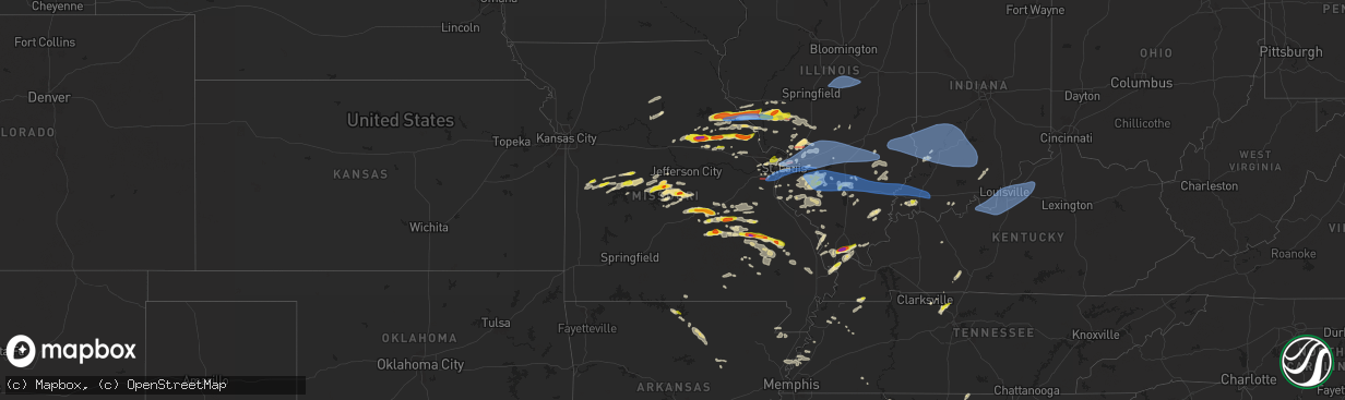
Hail Map in Missouri on April 18, 2024
The weather event in Missouri on April 18, 2024 includes Wind, Hail, and Tornado maps. 12 states and 753 cities were impacted and suffered possible damage. The total estimated number of properties impacted is 61,436.
Want more than just the map?
Turn this storm into a full workflow.
- Owner + property data so you know who to knock
- OnDemand branded weather history reports to win the "did we even have hail?" argument
- RoofTrace estimate so reps stop guessing numbers at the door
Bought this map? Upgrade within 7 days and we'll credit the $230. (10-15 min setup call)
Wind
Hail
Tornado
61,436
Estimated number of impacted properties by a 1.00" hail or larger10,327
Estimated number of impacted properties by a 1.75" hail or larger0
Estimated number of impacted properties by a 2.50" hail or largerStorm reports in Missouri
Missouri
| Date | Description |
|---|---|
| 04/18/20246:45 PM CDT | A local report indicates 1.00 inch wind near Caledonia |
| 04/18/20246:02 PM CDT | Time estimated from radar. |
| 04/18/20245:54 PM CDT | Power lines blown down at i-55 and lindbergh. |
| 04/18/20245:54 PM CDT | Turn signal light blown down by thunderstorm winds. |
| 04/18/20245:52 PM CDT | Report from mping: trees uprooted or snapped; roof blown off. |
| 04/18/20245:51 PM CDT | Report from mping: 3-inch tree limbs broken; power poles broken. |
| 04/18/20245:51 PM CDT | Report from mping: quarter |
| 04/18/20245:51 PM CDT | 2-3inch live limbs down... 2-3 up-rooted trees... Shingles off... Bent trees. |
| 04/18/20245:51 PM CDT | Photo of multiple large tree limbs down at covington manor ln and lemay ferry rd. |
| 04/18/20245:51 PM CDT | Report from mping: 1-inch tree limbs broken; shingles blown off. |
| 04/18/20245:50 PM CDT | Photo of large portion of pine tree fallen on the ground from social media. |
| 04/18/20245:50 PM CDT | Report from mping: 1-inch tree limbs broken; shingles blown off. |
| 04/18/20245:50 PM CDT | Report from mping: 1-inch tree limbs broken; shingles blown off. |
| 04/18/20245:50 PM CDT | Multiple large trees blown over. One of the fallen trees blocked a road... And another fallen tree fell on a neighborhood house. |
| 04/18/20245:49 PM CDT | Medium diameter tree broke at mid point from top. |
| 04/18/20245:48 PM CDT | A few shingles blown off of roofs. |
| 04/18/20245:48 PM CDT | Cocorahs observer reported quarter size hail and minor leaf damage. |
| 04/18/20245:45 PM CDT | Tree down... Time estimate from radar. |
| 04/18/20245:45 PM CDT | Several downed treee branches. |
| 04/18/20245:45 PM CDT | Golf ball sized hail 3 miles south of salem reported via law enforcement. |
| 04/18/20245:44 PM CDT | Flashing ripped off roof. |
| 04/18/20245:43 PM CDT | Report from mping: 1-inch tree limbs broken; shingles blown off. |
| 04/18/20245:41 PM CDT | Report from mping: 3-inch tree limbs broken; power poles broken. |
| 04/18/20245:38 PM CDT | Storm survey ongoing with ef0 tornado damage near high ridge along highway pp and along hunning road. This is a continuation of the track from twin rivers road |
| 04/18/20245:37 PM CDT | Photo of tree limb snapped and fallen on a home from social media. |
| 04/18/20245:33 PM CDT | Ef1 damage to buildings at business along twin rivers road. Tornado debris signature |
| 04/18/20245:30 PM CDT | Comment on social media with picture of hailstone next to quarter. |
| 04/18/20245:02 PM CDT | Half dollar size hail. The hail storm itself lasted about 10 minutes downing twigs and leaves everywhere and leaving the ground covered with hail in its wake. |
| 04/18/20244:56 PM CDT | Delayed report of quarter size hail on the north side of ionia. Time estimated from radar. |
| 04/18/20244:55 PM CDT | Portion of a motel roof blown off. Reported by law enforcement and confirmed via images in nwschat. Time estimated via radar. |
| 04/18/20244:55 PM CDT | Multiple reports of lots of quarter sized hail falling for several minutes. |
| 04/18/20244:55 PM CDT | A local report indicates 1.25 inch wind near Rolla |
| 04/18/20244:55 PM CDT | Public report of ping pong ball size hail on w 14th st south of interstate 44. |
| 04/18/20244:55 PM CDT | Public repor |
| 04/18/20244:55 PM CDT | Police reported multiple wires and some trees down in rolla. A 42 mph gust was also recorded just northeast of rolla. Time estimated via radar. |
| 04/18/20244:55 PM CDT | Image sent in of half-dollar sized hail. Time estimated via radar. |
| 04/18/20244:55 PM CDT | Tree uprooted just west of rolla city limits. Location estimated. Time estimated via radar. |
| 04/18/20244:55 PM CDT | A local report indicates 1.00 inch wind near 3 E Northwye |
| 04/18/20244:40 PM CDT | Photo of hail estimated to be at least quarter size on social media. |
| 04/18/20244:30 PM CDT | Photo of hail estimated to be at least golf ball size from social media. |
| 04/18/20244:28 PM CDT | Time estimate from radar. |
| 04/18/20244:11 PM CDT | A local report indicates 1.00 inch wind near 5 W Silex |
| 04/18/20244:00 PM CDT | A local report indicates 1.00 inch wind near 4 SE New Hartford |
| 04/18/20243:50 PM CDT | Golf ball sized hail estimated via image on social media. Time estimated via radar. |
| 04/18/20243:40 PM CDT | A local report indicates 1.00 inch wind near 3 SW Middletown |
| 04/18/20243:26 PM CDT | Time is radar estimate. |
| 04/18/20243:15 PM CDT | Image of golf ball sized hail received through the media via nwschat. Time estimated via radar. |
| 04/18/20243:15 PM CDT | Pictures received via social media with the largest hailstone estimated at ping pong size. Time estimated via radar. |
| 04/18/20243:15 PM CDT | Photo received via social media of quarter size hail in eldon... Mo. Time estimated via radar. |
| 04/18/20243:05 PM CDT | A local report indicates 2.00 inch wind near 2 SW Benton City |
| 04/18/20243:05 PM CDT | Time estimate from radar. |
| 04/18/20243:05 PM CDT | Time estimate from radar. |
| 04/18/20243:05 PM CDT | Time estimate from radar. |
| 04/18/20242:59 PM CDT | A local report indicates 1.50 inch wind near 5 S Vandiver |
| 04/18/20242:59 PM CDT | A local report indicates 2.00 inch wind near 4 SSW Mexico |
| 04/18/20242:57 PM CDT | A local report indicates 1.50 inch wind near 4 N Auxvasse |
| 04/18/20242:00 PM CDT | Delayed report of quarter size hail at mm 84 near truman lake state park. |
| 04/18/20241:19 PM CDT | Downed wires and power outages reported near 200p road. Time estimated from radar. |
| 04/18/20241:15 PM CDT | Hail up to half dollar size reported in the city limits of clinton. Time estimated from radar. |
| 04/18/20241:15 PM CDT | Quarter sized hail at wilder rv in northeast clinton. |
| 04/18/20241:13 PM CDT | Hail reported in downtown clinton. Hail size was estimated. |
| 04/18/20241:08 PM CDT | Delayed social media report of minor hail damage to multiple vehicles just west of clinton. Time based on social media report with location estimated from radar based o |
| 04/18/202412:41 PM CDT | Downed power lines and power outages near 1601 road. Time estimated from radar. |
| 04/17/202410:10 PM CDT | Delayed report. A couple trees down. |
| 04/17/20249:22 PM CDT | Delayed report. A couple trees down south of marble hill. |
| 04/17/20248:52 PM CDT | Delayed report. A few trees down... 1 shed with roof blown off... 1 small shed blown over. 2 tractor trailer cab shells blown over. Near intersection off dd and county |
| 04/17/20248:07 PM CDT | A local report indicates 1.00 inch wind near Annapolis |
| 04/17/20247:06 PM CDT | A local report indicates 1.00 inch wind near 6 N Lesterville |
All States Impacted by Hail Map on April 18, 2024
Cities Impacted by Hail Map on April 18, 2024
- Wamego, KS
- Belvue, KS
- Onaga, KS
- Westmoreland, KS
- Rossville, KS
- Saint Marys, KS
- Delia, KS
- Emmett, KS
- Havensville, KS
- Mayetta, KS
- Soldier, KS
- Holton, KS
- Topeka, KS
- Silver Lake, KS
- Hoyt, KS
- Denison, KS
- Valley Falls, KS
- Meriden, KS
- Ozawkie, KS
- Oskaloosa, KS
- Grantville, KS
- Effingham, KS
- Winchester, KS
- Atchison, KS
- Cummings, KS
- Nortonville, KS
- Lancaster, KS
- Perry, KS
- Tonganoxie, KS
- Leavenworth, KS
- McLouth, KS
- Lawrence, KS
- Easton, KS
- Rushville, MO
- Saint Joseph, MO
- Wathena, KS
- Troy, KS
- De Kalb, MO
- Weston, MO
- Agency, MO
- Dearborn, MO
- Faucett, MO
- Elwood, KS
- Fort Leavenworth, KS
- Easton, MO
- Bonner Springs, KS
- Basehor, KS
- Lansing, KS
- Linwood, KS
- Platte City, MO
- Farley, MO
- Smithville, MO
- Camden Point, MO
- Kansas City, KS
- Gower, MO
- Edgerton, MO
- Waldron, MO
- Shawnee, KS
- Kansas City, MO
- Riverside, MO
- Stewartsville, MO
- Trimble, MO
- Marion, LA
- Bernice, LA
- Spearsville, LA
- Farmerville, LA
- Bastrop, LA
- Bonita, LA
- Mer Rouge, LA
- Jones, LA
- Oak Grove, LA
- Lake Providence, LA
- Huttig, AR
- Marceline, MO
- Salisbury, MO
- New Cambria, MO
- Clifton Hill, MO
- Huntsville, MO
- Wilmot, AR
- Callao, MO
- Eudora, AR
- Hamburg, AR
- Mayersville, MS
- Urich, MO
- Butler, MO
- Montrose, MO
- Rolling Fork, MS
- Clinton, MO
- Deepwater, MO
- Calhoun, MO
- Hollandale, MS
- Lincoln, MO
- Warsaw, MO
- Cole Camp, MO
- Columbia, MO
- Harrisburg, MO
- Stover, MO
- Perry, MO
- Hallsville, MO
- Centralia, MO
- Center, MO
- Versailles, MO
- Thompson, MO
- Mexico, MO
- Auxvasse, MO
- New London, MO
- Vandalia, MO
- Frankford, MO
- Curryville, MO
- Gravois Mills, MO
- Barnett, MO
- Rocky Mount, MO
- Louisiana, MO
- Bowling Green, MO
- Benton City, MO
- Martinsburg, MO
- Eldon, MO
- Cape Girardeau, MO
- Empire, AL
- Yazoo City, MS
- Wellsville, MO
- Pleasant Hill, IL
- Rockport, IL
- Wolf Lake, IL
- Jonesboro, IL
- Hanceville, AL
- Alto Pass, IL
- Jackson, MO
- Kaiser, MO
- Louise, MS
- Silver City, MS
- Lake Ozark, MO
- Osage Beach, MO
- Tuscumbia, MO
- Saint Elizabeth, MO
- Rush Hill, MO
- Laddonia, MO
- Thebes, IL
- Eugene, MO
- Latham, MO
- Middletown, MO
- Cullman, AL
- Linn Creek, MO
- Bremen, AL
- Nebo, IL
- Pittsfield, IL
- Pearl, IL
- Meta, MO
- McClure, IL
- Williamsburg, MO
- Brumley, MO
- Fortuna, MO
- Ulman, MO
- Montgomery City, MO
- Clarksville, MO
- Montreal, MO
- Pickens, MS
- Lexington, MS
- Benton, MS
- Olean, MO
- Russellville, MO
- Henley, MO
- Kampsville, IL
- White Hall, IL
- Hillview, IL
- Silex, MO
- Saint Thomas, MO
- Jefferson City, MO
- Iberia, MO
- Blountsville, AL
- Tamms, IL
- Bellflower, MO
- Dixon, MO
- California, MO
- New Florence, MO
- Eolia, MO
- Kingdom City, MO
- Troy, MO
- Elsberry, MO
- Newburg, MO
- Hamilton, TX
- Pulaski, IL
- Dongola, IL
- Olmsted, IL
- Ullin, IL
- Vienna, MO
- Vaughan, MS
- Warrenton, MO
- Richland, MO
- Crocker, MO
- Annada, MO
- Patterson, IL
- Cypress, IL
- Winchester, IL
- Roodhouse, IL
- Murrayville, IL
- Rolla, MO
- Belknap, IL
- Vienna, IL
- Jerome, MO
- New Market, AL
- Meridianville, AL
- Pottsville, TX
- Grand Chain, IL
- Windsor, MO
- Goodman, MS
- Wright City, MO
- Karnak, IL
- Greenfield, IL
- Palmyra, IL
- Modesto, IL
- Foristell, MO
- Hazel Green, AL
- Hamburg, IL
- Camden, MS
- Mullin, TX
- Saint James, MO
- Sedalia, MO
- Mora, MO
- Hettick, IL
- Goldthwaite, TX
- Richland Springs, TX
- Chesterfield, MO
- Ripley, TN
- Ionia, MO
- Green Ridge, MO
- Charleston, MO
- Cary, MS
- Rochelle, TX
- Carrollton, IL
- Wrights, IL
- Eldred, IL
- Fieldon, IL
- Evant, TX
- Barlow, KY
- Cairo, IL
- Cuba, MO
- Kevil, KY
- Saint Louis, MO
- Simpson, IL
- Grantsburg, IL
- Maryland Heights, MO
- Saint Ann, MO
- Bridgeton, MO
- La Center, KY
- Barry, IL
- New Canton, IL
- Licking, MO
- Salem, MO
- San Saba, TX
- Star, TX
- Steelville, MO
- Carlinville, IL
- Gustine, TX
- Girard, IL
- Hazelwood, MO
- Kane, IL
- Worden, IL
- Fenton, MO
- High Ridge, MO
- Leasburg, MO
- Eureka, MO
- Florissant, MO
- Cook Sta, MO
- Granite City, IL
- Cedar Hill, MO
- Hillsboro, MO
- Dittmer, MO
- Valley Park, MO
- Staunton, IL
- Bunker Hill, IL
- Metropolis, IL
- Holly Pond, AL
- Ranburne, AL
- Graham, AL
- Woodland, AL
- Waggoner, IL
- Golconda, IL
- Sullivan, MO
- Bourbon, MO
- Potosi, MO
- Collinsville, IL
- Moro, IL
- House Springs, MO
- Imperial, MO
- East Carondelet, IL
- Arnold, MO
- Columbia, IL
- Dupo, IL
- East Saint Louis, IL
- Belleville, IL
- Millstadt, IL
- Fairview Heights, IL
- Caseyville, IL
- Cherryville, MO
- Valmeyer, IL
- Barnhart, MO
- Venice, IL
- Madison, IL
- Mount Olive, IL
- Bowdon, GA
- Heflin, AL
- Nilwood, IL
- Satartia, MS
- Cadet, MO
- Blackwell, MO
- Bentonia, MS
- East Alton, IL
- Alton, IL
- Bethalto, IL
- Edwardsville, IL
- Saint Jacob, IL
- Glen Carbon, IL
- Troy, IL
- Maryville, IL
- O'Fallon, IL
- Lebanon, IL
- Marine, IL
- Sorento, IL
- Walshville, IL
- New Douglas, IL
- Hamel, IL
- Alhambra, IL
- Highland, IL
- Trenton, IL
- Pocahontas, IL
- Davisville, MO
- Aviston, IL
- Greenville, IL
- Breese, IL
- Jacksonville, IL
- Waterloo, IL
- Smithton, IL
- Lometa, TX
- Ashland City, TN
- White Bluff, TN
- Clarksville, TN
- Boss, MO
- Bunker, MO
- Dorsey, IL
- Raymond, IL
- Litchfield, IL
- Butler, IL
- Donnellson, IL
- Hillsboro, IL
- Panama, IL
- Summerfield, IL
- Sedalia, KY
- Flora, MS
- Madison, MS
- Canton, MS
- Freeburg, IL
- Belgrade, MO
- Fulton, KY
- Black, MO
- Bloomsdale, MO
- Festus, MO
- New Athens, IL
- Martin, TN
- Dresden, TN
- Pleasant View, TN
- Joelton, TN
- Springfield, TN
- Smithboro, IL
- Carlyle, IL
- Keyesport, IL
- Fillmore, IL
- Mulberry Grove, IL
- Vandalia, IL
- Coffeen, IL
- Ramsey, IL
- Nashville, IL
- Albers, IL
- Addieville, IL
- Germantown, IL
- Saint Libory, IL
- Marissa, IL
- Bartelso, IL
- Oakdale, IL
- Okawville, IL
- Mascoutah, IL
- New Baden, IL
- Bixby, MO
- Lesterville, MO
- Lenzburg, IL
- Fults, IL
- Lampasas, TX
- Caledonia, MO
- Palmersville, TN
- Dukedom, TN
- Red Bud, IL
- Prairie Du Rocher, IL
- Bismarck, MO
- Ironton, MO
- Greenbrier, TN
- Vernon, IL
- Alma, IL
- Patoka, IL
- Salem, IL
- Shobonier, IL
- Odin, IL
- Sandoval, IL
- Brownstown, IL
- Saint Peter, IL
- Kinmundy, IL
- Coulterville, IL
- Baldwin, IL
- Evansville, IL
- Sparta, IL
- Cowden, IL
- Farmington, KY
- Viburnum, MO
- Belleview, MO
- Oconee, IL
- Walsh, IL
- Ellis Grove, IL
- Irondale, MO
- Ashley, IL
- Richview, IL
- Du Bois, IL
- Hoyleton, IL
- Centralia, IL
- Hoffman, IL
- Cherokee, TX
- Arcadia, MO
- Fredericktown, MO
- Cutler, IL
- Chester, IL
- Percy, IL
- Steeleville, IL
- Annapolis, MO
- Mount Pulaski, IL
- Warrensburg, IL
- Decatur, IL
- Illiopolis, IL
- Niantic, IL
- Latham, IL
- Chestnut, IL
- Forsyth, IL
- Maroa, IL
- Oreana, IL
- Mason, IL
- Louisville, IL
- Flora, IL
- Farina, IL
- Xenia, IL
- Edgewood, IL
- Saint Elmo, IL
- Irvington, IL
- Walnut Hill, IL
- Woodlawn, IL
- Opdyke, IL
- Mount Vernon, IL
- Dix, IL
- Waltonville, IL
- Texico, IL
- Bluford, IL
- Kell, IL
- Iuka, IL
- Pinckneyville, IL
- Lakewood, IL
- Centerville, MO
- Valley Spring, TX
- Voca, TX
- Pontotoc, TX
- Fredonia, TX
- Argenta, IL
- Cisco, IL
- Cerro Gordo, IL
- Ingraham, IL
- Clay City, IL
- Sailor Springs, IL
- Keenes, IL
- Wayne City, IL
- Johnsonville, IL
- Sims, IL
- Bonnie, IL
- Campbell Hill, IL
- Adams, TN
- Milmine, IL
- Monticello, IL
- Noble, IL
- Newton, IL
- Barnhill, IL
- Fairfield, IL
- Geff, IL
- Marquand, MO
- Llano, TX
- Ewing, IL
- Art, TX
- Adairville, KY
- Vichy, MO
- Dieterich, IL
- Ava, IL
- Vergennes, IL
- Du Quoin, IL
- Belle Rive, IL
- Dahlgren, IL
- Springerton, IL
- Mill Shoals, IL
- Burnt Prairie, IL
- Carmi, IL
- Golden Gate, IL
- Ellery, IL
- Albion, IL
- Cisne, IL
- Mount Erie, IL
- Des Arc, MO
- Vulcan, MO
- Olney, IL
- Macedonia, IL
- Ellington, MO
- Crossville, IL
- Grayville, IL
- Mount Carmel, IL
- Browns, IL
- Winona, MO
- Castell, TX
- Patterson, MO
- Eldorado, IL
- Raleigh, IL
- Silva, MO
- Lodi, MO
- Caulfield, MO
- West Salem, IL
- Parkersburg, IL
- Poseyville, IN
- Griffin, IN
- Owensville, IN
- Cynthiana, IN
- Wildwood, MO
- Wood River, IL
- Roxana, IL
- Mountain Home, AR
- Norris City, IL
- Omaha, IL
- Broughton, IL
- Auburn, KY
- Bakersfield, MO
- Mason, TX
- Glenallen, MO
- Greenville, MO
- Clubb, MO
- Centertown, KY
- Lewis, IN
- Plainville, IN
- Linton, IN
- Jasonville, IN
- Lyons, IN
- Carlisle, IN
- Worthington, IN
- Sullivan, IN
- Dugger, IN
- Clay City, IN
- Sandborn, IN
- Edwardsport, IN
- Washington, IN
- Westphalia, IN
- Oaktown, IN
- Flat Rock, IL
- Hutsonville, IL
- Bicknell, IN
- Shelburn, IN
- Palestine, IL
- Oblong, IL
- Freelandville, IN
- Lawrenceville, IL
- Willow Hill, IL
- Fairbanks, IN
- Robinson, IL
- Coalmont, IN
- Bruceville, IN
- Farmersburg, IN
- Stoy, IL
- Hymera, IN
- Merom, IN
- West Liberty, IL
- Annapolis, IL
- West York, IL
- Sainte Marie, IL
- Sumner, IL
- Marble Hill, MO
- Fremont, MO
- Ridgeland, MS
- Van Buren, MO
- Jackson, MS
- Alton, MO
- Haubstadt, IN
- Fort Branch, IN
- Elberfeld, IN
- Lynnville, IN
- Princeton, IN
- Francisco, IN
- Oakland City, IN
- Wadesville, IN
- Zalma, MO
- Rockfield, KY
- Ellsinore, MO
- Mill Spring, MO
- Evansville, IN
- Norfork, AR
- Calico Rock, AR
- Freedom, IN
- Poland, IN
- Newberry, IN
- Coal City, IN
- Patricksburg, IN
- Bloomfield, IN
- Bowling Green, IN
- Switz City, IN
- Spencer, IN
- Elnora, IN
- Solsberry, IN
- Montgomery, IN
- Crane, IN
- Scotland, IN
- Odon, IN
- Loogootee, IN
- Boonville, IN
- Ridgway, IL
- Equality, IL
- Advance, MO
- Sturdivant, MO
- Williamsville, MO
- Bloomington, IN
- Owensburg, IN
- Springville, IN
- Shoals, IN
- Williams, IN
- Mitchell, IN
- Pineville, AR
- Hardinsburg, IN
- Fredericksburg, IN
- Murphysboro, IL
- Pomona, IL
- Altenburg, MO
- Grand Tower, IL
- Bedford, IN
- Orleans, IN
- West Baden Springs, IN
- Oolitic, IN
- Gosport, IN
- Avoca, IN
- Heltonville, IN
- Ellettsville, IN
- Tell City, IN
- Troy, IN
- Evanston, IN
- Melbourne, AR
- Salem, IN
- Lamar, IN
- Bell City, MO
- Tunnelton, IN
- Campbellsburg, IN
- Oran, MO
- Sikeston, MO
- Vanduser, MO
- Mount Pleasant, AR
- Guion, AR
- Truxton, MO
- Batesville, AR
- South Roxana, IL
- Cottage Hills, IL
- Truesdale, MO
- Batchtown, IL
- Shipman, IL
- Webster, KY
- Guston, KY
- Battletown, KY
- Brandenburg, KY
- Payneville, KY
- Fort Knox, KY
- Ekron, KY
- Vine Grove, KY
- New Middletown, IN
- Lanesville, IN
- Corydon, IN
- Muldraugh, KY
- Elizabeth, IN
- Clarksville, IN
- Mauckport, IN
- Laconia, IN
- Louisville, KY
- New Albany, IN
- West Point, KY
- Fairdale, KY
- Mount Washington, KY
- Taylorsville, KY
- Fisherville, KY
- Brooks, KY
- Shepherdsville, KY
- Jeffersonville, IN
- Masonic Home, KY
- Lebanon Junction, KY
- Glenview, KY
- Pewee Valley, KY
- Crestwood, KY
- Prospect, KY
- Simpsonville, KY
- Gorham, IL
- Shelbyville, KY
- Finchville, KY
- Smithfield, KY
- Eminence, KY
- Pleasureville, KY
- La Grange, KY
- Buckner, KY
- New Castle, KY
- Bradford, AR
- Pleasant Plains, AR
- Oil Trough, AR
- Paragould, AR
- Cardwell, MO
- Arbyrd, MO
- Trimble, TN
- Newbern, TN
- Leachville, AR
- Manila, AR
- Roland, AR
- Kenton, TN
- Little Rock, AR
- Rutherford, TN
- Bradford, TN
- Joiner, AR
- Trenton, TN
- Milan, TN
- Mabelvale, AR
- Henning, TN
- Burlison, TN
- Alexander, AR
- Bryant, AR
- Wilson, AR
- Drummonds, TN
- Munford, TN
- Brighton, TN
- Covington, TN
- Hensley, AR
- Redfield, AR
- Sheridan, AR
- Jefferson, AR
- Marvell, AR
- Holly Grove, AR
- Lexa, AR
- Helena, AR
- Bethel Springs, TN
- Selmer, TN
- Stantonville, TN
- Burnsville, MS
- Iuka, MS
- Cherokee, AL
- Tishomingo, MS
- Tuscumbia, AL
- Russellville, AL


