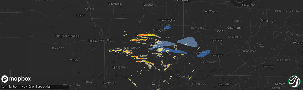
Hail Map on April 18, 2024
The weather event on April 18, 2024 includes Wind, Hail, and Tornado maps. 12 states and 753 cities were impacted and suffered possible damage. The total estimated number of properties impacted is 84,754.
Want more than just the map?
Turn this storm into a full workflow.
- Owner + property data so you know who to knock
- OnDemand branded weather history reports to win the "did we even have hail?" argument
- RoofTrace estimate so reps stop guessing numbers at the door
Bought this map? Upgrade within 7 days and we'll credit the $230. (10-15 min setup call)
Wind
Hail
Tornado
84,754
Estimated number of impacted properties by a 1.00" hail or larger13,814
Estimated number of impacted properties by a 1.75" hail or larger0
Estimated number of impacted properties by a 2.50" hail or largerStates Impacted by Hail Map on April 18, 2024
Storm reports
Tennessee
| Date | Description |
|---|---|
| 04/18/20246:56 PM CDT | A local report indicates 1.00 inch wind near 2 E Coopertown |
| 04/17/20247:14 PM CDT | A tree fell on a house on shelton st causing minor to moderate damage to the house. |
| 04/17/20247:09 PM CDT | A local report indicates 1.00 inch wind near 3 SSE Springfield |
Alabama
| Date | Description |
|---|---|
| 04/18/20244:02 PM CDT | Quarter size hail in center hill. |
| 04/18/20243:53 PM CDT | Trees and powerlines down near the intersection of section line and magnolia ave. |
| 04/18/20243:40 PM CDT | Trees down in dodge city. |
| 04/18/20246:12 AM CDT | Quarter size hail reported north of russellville... Al. Time estimated based on radar. |
Arkansas
| Date | Description |
|---|---|
| 04/18/20242:38 AM CDT | Multiple trees and power lines down in the town of redf |
| 04/18/20242:38 AM CDT | Multiple trees and power lines down in the town of redfield. Damage also noted to a mobile home that a tree fell on and to the roof of a church. |
| 04/18/20241:42 AM CDT | A local report indicates 63 MPH wind near 6 SW Little Rock |
Kentucky
| Date | Description |
|---|---|
| 04/17/202411:55 PM CDT | Measured at the ky mesonet station crop. |
| 04/17/202411:17 PM CDT | A large tree fell onto a house in st matthews... Resulting in damage to the house. |
| 04/17/202411:12 PM CDT | Measured at louisville muhammad ali international airport. |
| 04/17/202410:55 PM CDT | Tree down over highway 60 near hill grove. |
Indiana
| Date | Description |
|---|---|
| 04/17/202410:47 PM CDT | Tree down on beech road. |
| 04/17/202410:45 PM CDT | A live... Well established pine tree was snapped at its base in a neighborhood in the tipton lakes area. |
| 04/17/202410:40 PM CDT | Trees down over new amsterdam road in valley city. |
| 04/17/202410:37 PM CDT | Trees down in downtown new amsterdam. |
| 04/17/202410:13 PM CDT | Tree down on state road 37 near branchville. |
| 04/17/20249:51 PM CDT | Tree in roadway on county road 175e. |
| 04/17/20249:45 PM CDT | Tree and power line on fire in the 2500 block of n portersville rd. Time estimated from radar. |
| 04/17/20249:42 PM CDT | Dispatch reported tree in roadway on sr64 2 miles east of sr161. Time estimated from radar. |
| 04/17/20249:39 PM CDT | Multiple tree limbs and branches downed along state route 54 near eastern greene middle school. |
| 04/17/20249:33 PM CDT | Delayed report. Multiple large tree limbs down 4 to 5 inches in diameter. Report received via social media. |
| 04/17/20249:27 PM CDT | Tree down on s barker |
| 04/17/20249:27 PM CDT | Tree down on s barker near edgewood. |
| 04/17/20249:23 PM CDT | Tree down across 1050w west of lyons. |
| 04/17/20249:22 PM CDT | A local report indicates 1.00 inch wind near 3 E Darmstadt |
| 04/17/20249:15 PM CDT | 11419 sugar lane about 6 miles south of terre haute....several large trees down. |
| 04/17/20249:13 PM CDT | Delayed report. A couple trees down. Dime size hail. Report received via social media. |
| 04/17/20249:13 PM CDT | A local report indicates 60 MPH wind near Bicknell |
| 04/17/20249:13 PM CDT | Report of a semi overturned on us 41 near vincennes. |
| 04/17/20249:11 PM CDT | Tree uprooted on the south side of princeton. |
| 04/17/20249:08 PM CDT | Starting to get reports of trees and utility lines down within vincennes. |
| 04/17/20249:00 PM CDT | A local report indicates 60 MPH wind near 1 SSW Sullivan |
Texas
| Date | Description |
|---|---|
| 04/18/20246:20 PM CDT | Multiple trees down across the city of san saba. |
| 04/18/20246:15 PM CDT | Quarter to ping pong ball sized hail reported in downtown san saba. |
| 04/18/20245:23 PM CDT | Relayed image of multiple half dollar hail stones and a ping pong sized hail stone. Time estimated via radar. |
| 04/18/20245:17 PM CDT | Social media report of golf ball sized hail. |
| 04/18/20245:07 PM CDT | Social media image of measured 2.25 inch hailstone. |
| 04/17/20247:00 PM CDT | A local report indicates 1.50 inch wind near 4 WSW Chappel |
Illinois
| Date | Description |
|---|---|
| 04/18/20246:57 PM CDT | Numerous tr |
| 04/18/20246:57 PM CDT | Numerous trees were blown down from riverton eastward. |
| 04/18/20246:55 PM CDT | Corrects previous tstm wnd dmg report from 2 sw hagerstown. Trees downed across illinois route 140 at 300 st and just east of hagerstown. Time estimated from radar. |
| 04/18/20246:55 PM CDT | Tree debris was found off of i-64 at the okawville exit. Time estimated from radar. |
| 04/18/20246:55 PM CDT | A local report indicates 1.25 inch wind near Okawville |
| 04/18/20246:19 PM CDT | Report from mping: 3-inch tree limbs broken; power poles broken. |
| 04/18/20246:18 PM CDT | Photo of a tree snapped in half at rustic acres jellystone park from social media. |
| 04/18/20246:18 PM CDT | Report from mping: 3-inch tree limbs broken; power poles broken. |
| 04/18/20246:18 PM CDT | Power poles down. |
| 04/18/20246:15 PM CDT | Downed tree and powerlines. |
| 04/18/20246:15 PM CDT | Trees down... Trees in houses... And powerlines down. |
| 04/18/20246:14 PM CDT | Corrects previous tstm wnd dmg report from marine. Trees down... Trees in houses... And powerlines down. Nws survey team determined the damage was from a ef0 tornado. M |
| 04/18/20246:14 PM CDT | Corrects previous tornado report from marine. Corrects previous tstm wnd dmg report from marine. Trees down... Trees in houses... And powerlines down. |
| 04/18/20246:09 PM CDT | Tree damage |
| 04/18/20246:06 PM CDT | Power poles down. |
| 04/18/20246:05 PM CDT | Large tree blown over. |
| 04/18/20246:04 PM CDT | Report from mping: ping pong ball |
| 04/18/20246:02 PM CDT | Report from mping: trees uprooted or snapped; roof blown off. |
| 04/18/20246:01 PM CDT | Corrects previous tstm wnd dmg report from 1 s prairietown. Report from mping: trees uprooted or snapped; roof blown off. Nws survey team found ef1 damage with max wind |
| 04/18/20245:58 PM CDT | The tornado touched down near the western edge of the prairies of cahokia golf course and moved east for about 1.1 miles where it lifted near the intersection of carol |
| 04/18/20245:57 PM CDT | Report from mping: 1-inch tree limbs broken; shingles blown off. |
| 04/18/20245:57 PM CDT | Report from mping: 3-inch tree limbs broken; power poles broken. |
| 04/18/20245:52 PM CDT | Tree damage with winds up to 80 mph. Nws storm survey continues. |
| 04/18/20245:52 PM CDT | A brief tornado touched down south of standard city where it damaged the roofs of 3 farm sheds. The tornado moved southeast across south standard city rd where it cause |
| 04/18/20245:40 PM CDT | Location approximate... Time estimate from radar... Multiple trees and powerlines down. |
| 04/18/20245:36 PM CDT | Spotter reported a brief tornado touchdown. Storm survey did not find any damage so rated efu. |
| 04/18/20245:12 PM CDT | Video of a tornado taken from a business on palmyra rd from social media--time estimated from radar. |
| 04/18/20245:10 PM CDT | Tree down across highway 37 between cairo and mounds city. |
| 04/18/20244:46 PM CDT | Relayed via facebook. |
| 04/18/20244:45 PM CDT | Corrects previous hail report from 3 s cypress. Delayed report. Hail larger than golfballs. |
| 04/18/20244:40 PM CDT | Observer also reported a horizontal roll cloud. |
| 04/18/20244:37 PM CDT | A local report indicates 1.00 inch wind near Roodhouse |
| 04/18/20244:36 PM CDT | A local report indicates 1.00 inch wind near 1 NNE White Hall |
| 04/18/20243:54 PM CDT | Time estimate from radar. Also golf ball sized hail. |
| 04/18/20243:38 PM CDT | Corrects previous tstm wnd dmg report from 2 w nebo. In pleasant hill... A trampoline was thrown into power line... Then tossed 80 ft up into a tree. A 2.5 ft section o |
| 04/17/20248:42 PM CDT | Delayed report. Tree down at grange grove. |
| 04/17/20248:40 PM CDT | Report of a power line down into a tree. Kcmi gusted to 52 mph with storms. |
| 04/17/20248:35 PM CDT | Several large trees down. |
| 04/17/20248:18 PM CDT | Metal roof blown off a large building along us 45 at county road 620 north. Relayed via twitter. |
| 04/17/20248:15 PM CDT | A large tree fell onto a trailer home. |
| 04/17/20248:13 PM CDT | Measured 1 mile north of mile marker 100 on interstate 64. |
| 04/17/20247:53 PM CDT | Delayed report. Garage roof blown off. Four utility poles and multiple trees blown down. Time estimated by radar. |
| 04/17/20247:49 PM CDT | Delayed report. Large tree blown over. |
| 04/17/20247:49 PM CDT | Delayed report. Social media images show a destroyed grain bin and a damaged farm outbuilding. |
| 04/17/20247:49 PM CDT | Large tree snapped and numerous branches down. Pictures via social media. Time estimated from radar. |
| 04/17/20247:47 PM CDT | Delayed report. Semi blown over on interstate 72 at mile marker 150. |
| 04/17/20247:45 PM CDT | Power poles tilted over on route 48 between oreana and argenta. Time estimated from radar. |
| 04/17/20247:44 PM CDT | Tree down on highway 37 at gun creek. |
| 04/17/20247:43 PM CDT | A local report indicates 1.25 inch wind near Woodlawn |
| 04/17/20247:41 PM CDT | Corrects previous hail report from woodlawn. |
| 04/17/20247:38 PM CDT | Numerous power lines were blown down. |
| 04/17/20247:38 PM CDT | Numerous power lin |
| 04/17/20247:37 PM CDT | Delayed report. Semi blown over on emery road near route 51. |
| 04/17/20247:37 PM CDT | Nws storm damage survey confirmed an ef-1 tornado with estimated peak winds of 90 mph in macon county 3 miles north-northwest of forsyth. The damage path is 7 miles wit |
| 04/17/20247:35 PM CDT | Tree limbs down. |
| 04/17/20247:34 PM CDT | Marion county sheriffs office reported a tree on state route 161 extension at lincoln road. Time estimated by radar. |
| 04/17/20247:34 PM CDT | Delayed report. Semi blown over on i-72 at mile marker 139. |
| 04/17/20247:34 PM CDT | Delayed report. Semi blown over on interstate 72 at mile marker 139. |
| 04/17/20247:29 PM CDT | Delayed report. Roof blown off house. |
| 04/17/20247:25 PM CDT | Marion county sheriffs office reported a tree down on st. Peter road at i-57. Time estimated from radar. |
| 04/17/20247:22 PM CDT | Nws storm survey damage survey confirmed an ef-1 tornado with estimated peak winds of 95 mph in southeast logan and northwest macon counties that moved southeast and th |
| 04/17/20247:22 PM CDT | Trees downed in the brownstown area. Time estimated from radar. |
| 04/17/20247:22 PM CDT | Trees and limbs down. |
| 04/17/20247:20 PM CDT | The roof of a home was severely damaged. |
| 04/17/20247:20 PM CDT | A semi was overturned on route 121 near latham. Possible injuries. |
| 04/17/20247:20 PM CDT | A tree was blown down. |
| 04/17/20247:20 PM CDT | Nws storm damage survey confirmed an ef-0 tornado with estimated peak winds of 85 mph near latham... Il. The damage path length is 1.11 miles and max width of 200 yds. |
| 04/17/20247:20 PM CDT | Report from mping: 3-inch tree limbs broken; power poles broken. |
| 04/17/20247:19 PM CDT | Corrects previous tstm wnd dmg report from 3 wsw latham. Several trees were down... But no structural damage was noted in this area. |
| 04/17/20247:19 PM CDT | A roof collapsed. |
| 04/17/20247:18 PM CDT | Report from mping: trees uprooted or snapped; roof blown off. |
| 04/17/20247:18 PM CDT | Three power poles are leaning near the intersection of route 121 and 1842nd avenue. |
| 04/17/20247:02 PM CDT | A local report indicates 1.00 inch wind near 2 S Addieville |
Mississippi
| Date | Description |
|---|---|
| 04/18/20244:18 PM CDT | A few trees and a power line were blown down across roads in pickens. Pictures of the damage were relayed by broadcast media. |
| 04/18/20243:08 PM CDT | Local law enforcement reported several down power poles across midnight and the silver city area. |
| 04/18/202410:10 AM CDT | A tree was reported down near wynn rd by law enforcement. |
| 04/17/20247:00 PM CDT | Ping pong size hail reported near whisper lake. |
Missouri
| Date | Description |
|---|---|
| 04/18/20246:45 PM CDT | A local report indicates 1.00 inch wind near Caledonia |
| 04/18/20246:02 PM CDT | Time estimated from radar. |
| 04/18/20245:54 PM CDT | Turn signal light blown down by thunderstorm winds. |
| 04/18/20245:54 PM CDT | Power lines blown down at i-55 and lindbergh. |
| 04/18/20245:52 PM CDT | Report from mping: trees uprooted or snapped; roof blown off. |
| 04/18/20245:51 PM CDT | Report from mping: 3-inch tree limbs broken; power poles broken. |
| 04/18/20245:51 PM CDT | Report from mping: quarter |
| 04/18/20245:51 PM CDT | Report from mping: 1-inch tree limbs broken; shingles blown off. |
| 04/18/20245:51 PM CDT | 2-3inch live limbs down... 2-3 up-rooted trees... Shingles off... Bent trees. |
| 04/18/20245:51 PM CDT | Photo of multiple large tree limbs down at covington manor ln and lemay ferry rd. |
| 04/18/20245:50 PM CDT | Report from mping: 1-inch tree limbs broken; shingles blown off. |
| 04/18/20245:50 PM CDT | Photo of large portion of pine tree fallen on the ground from social media. |
| 04/18/20245:50 PM CDT | Report from mping: 1-inch tree limbs broken; shingles blown off. |
| 04/18/20245:50 PM CDT | Multiple large trees blown over. One of the fallen trees blocked a road... And another fallen tree fell on a neighborhood house. |
| 04/18/20245:49 PM CDT | Medium diameter tree broke at mid point from top. |
| 04/18/20245:48 PM CDT | A few shingles blown off of roofs. |
| 04/18/20245:48 PM CDT | Cocorahs observer reported quarter size hail and minor leaf damage. |
| 04/18/20245:45 PM CDT | Tree down... Time estimate from radar. |
| 04/18/20245:45 PM CDT | Golf ball sized hail 3 miles south of salem reported via law enforcement. |
| 04/18/20245:45 PM CDT | Several downed treee branches. |
| 04/18/20245:44 PM CDT | Flashing ripped off roof. |
| 04/18/20245:43 PM CDT | Report from mping: 1-inch tree limbs broken; shingles blown off. |
| 04/18/20245:41 PM CDT | Report from mping: 3-inch tree limbs broken; power poles broken. |
| 04/18/20245:38 PM CDT | Storm survey ongoing with ef0 tornado damage near high ridge along highway pp and along hunning road. This is a continuation of the track from twin rivers road |
| 04/18/20245:37 PM CDT | Photo of tree limb snapped and fallen on a home from social media. |
| 04/18/20245:33 PM CDT | Ef1 damage to buildings at business along twin rivers road. Tornado debris signature |
| 04/18/20245:30 PM CDT | Comment on social media with picture of hailstone next to quarter. |
| 04/18/20245:02 PM CDT | Half dollar size hail. The hail storm itself lasted about 10 minutes downing twigs and leaves everywhere and leaving the ground covered with hail in its wake. |
| 04/18/20244:56 PM CDT | Delayed report of quarter size hail on the north side of ionia. Time estimated from radar. |
| 04/18/20244:55 PM CDT | Tree uprooted just west of rolla city limits. Location estimated. Time estimated via radar. |
| 04/18/20244:55 PM CDT | Portion of a motel roof blown off. Reported by law enforcement and confirmed via images in nwschat. Time estimated via radar. |
| 04/18/20244:55 PM CDT | A local report indicates 1.25 inch wind near Rolla |
| 04/18/20244:55 PM CDT | Image sent in of half-dollar sized hail. Time estimated via radar. |
| 04/18/20244:55 PM CDT | Police reported multiple wires and some trees down in rolla. A 42 mph gust was also recorded just northeast of rolla. Time estimated via radar. |
| 04/18/20244:55 PM CDT | Public repor |
| 04/18/20244:55 PM CDT | Public report of ping pong ball size hail on w 14th st south of interstate 44. |
| 04/18/20244:55 PM CDT | Multiple reports of lots of quarter sized hail falling for several minutes. |
| 04/18/20244:55 PM CDT | A local report indicates 1.00 inch wind near 3 E Northwye |
| 04/18/20244:40 PM CDT | Photo of hail estimated to be at least quarter size on social media. |
| 04/18/20244:30 PM CDT | Photo of hail estimated to be at least golf ball size from social media. |
| 04/18/20244:28 PM CDT | Time estimate from radar. |
| 04/18/20244:11 PM CDT | A local report indicates 1.00 inch wind near 5 W Silex |
| 04/18/20244:00 PM CDT | A local report indicates 1.00 inch wind near 4 SE New Hartford |
| 04/18/20243:50 PM CDT | Golf ball sized hail estimated via image on social media. Time estimated via radar. |
| 04/18/20243:40 PM CDT | A local report indicates 1.00 inch wind near 3 SW Middletown |
| 04/18/20243:26 PM CDT | Time is radar estimate. |
| 04/18/20243:15 PM CDT | Photo received via social media of quarter size hail in eldon... Mo. Time estimated via radar. |
| 04/18/20243:15 PM CDT | Image of golf ball sized hail received through the media via nwschat. Time estimated via radar. |
| 04/18/20243:15 PM CDT | Pictures received via social media with the largest hailstone estimated at ping pong size. Time estimated via radar. |
| 04/18/20243:05 PM CDT | A local report indicates 2.00 inch wind near 2 SW Benton City |
| 04/18/20243:05 PM CDT | Time estimate from radar. |
| 04/18/20243:05 PM CDT | Time estimate from radar. |
| 04/18/20243:05 PM CDT | Time estimate from radar. |
| 04/18/20242:59 PM CDT | A local report indicates 2.00 inch wind near 4 SSW Mexico |
| 04/18/20242:59 PM CDT | A local report indicates 1.50 inch wind near 5 S Vandiver |
| 04/18/20242:57 PM CDT | A local report indicates 1.50 inch wind near 4 N Auxvasse |
| 04/18/20242:00 PM CDT | Delayed report of quarter size hail at mm 84 near truman lake state park. |
| 04/18/20241:19 PM CDT | Downed wires and power outages reported near 200p road. Time estimated from radar. |
| 04/18/20241:15 PM CDT | Hail up to half dollar size reported in the city limits of clinton. Time estimated from radar. |
| 04/18/20241:15 PM CDT | Quarter sized hail at wilder rv in northeast clinton. |
| 04/18/20241:13 PM CDT | Hail reported in downtown clinton. Hail size was estimated. |
| 04/18/20241:08 PM CDT | Delayed social media report of minor hail damage to multiple vehicles just west of clinton. Time based on social media report with location estimated from radar based o |
| 04/18/202412:41 PM CDT | Downed power lines and power outages near 1601 road. Time estimated from radar. |
| 04/17/202410:10 PM CDT | Delayed report. A couple trees down. |
| 04/17/20249:22 PM CDT | Delayed report. A couple trees down south of marble hill. |
| 04/17/20248:52 PM CDT | Delayed report. A few trees down... 1 shed with roof blown off... 1 small shed blown over. 2 tractor trailer cab shells blown over. Near intersection off dd and county |
| 04/17/20248:07 PM CDT | A local report indicates 1.00 inch wind near Annapolis |
| 04/17/20247:06 PM CDT | A local report indicates 1.00 inch wind near 6 N Lesterville |
Louisiana
| Date | Description |
|---|---|
| 04/18/20243:58 PM CDT | Local law enforcement reported a tree down on hwy 879 near oak grove. |
| 04/18/20249:10 AM CDT | Law enforcement reported a tree down near hughes chapel rd due to yesterdays storms. |
Cities Impacted by Hail Map on April 18, 2024
- Wamego, KS
- Belvue, KS
- Onaga, KS
- Westmoreland, KS
- Rossville, KS
- Saint Marys, KS
- Delia, KS
- Emmett, KS
- Havensville, KS
- Mayetta, KS
- Soldier, KS
- Holton, KS
- Topeka, KS
- Silver Lake, KS
- Hoyt, KS
- Denison, KS
- Valley Falls, KS
- Meriden, KS
- Ozawkie, KS
- Oskaloosa, KS
- Grantville, KS
- Effingham, KS
- Winchester, KS
- Atchison, KS
- Cummings, KS
- Nortonville, KS
- Lancaster, KS
- Perry, KS
- Tonganoxie, KS
- Leavenworth, KS
- McLouth, KS
- Lawrence, KS
- Easton, KS
- Rushville, MO
- Saint Joseph, MO
- Wathena, KS
- Troy, KS
- De Kalb, MO
- Weston, MO
- Agency, MO
- Dearborn, MO
- Faucett, MO
- Elwood, KS
- Fort Leavenworth, KS
- Easton, MO
- Bonner Springs, KS
- Basehor, KS
- Lansing, KS
- Linwood, KS
- Platte City, MO
- Farley, MO
- Smithville, MO
- Camden Point, MO
- Kansas City, KS
- Gower, MO
- Edgerton, MO
- Waldron, MO
- Shawnee, KS
- Kansas City, MO
- Riverside, MO
- Stewartsville, MO
- Trimble, MO
- Marion, LA
- Bernice, LA
- Spearsville, LA
- Farmerville, LA
- Bastrop, LA
- Bonita, LA
- Mer Rouge, LA
- Jones, LA
- Oak Grove, LA
- Lake Providence, LA
- Huttig, AR
- Marceline, MO
- Salisbury, MO
- New Cambria, MO
- Clifton Hill, MO
- Huntsville, MO
- Wilmot, AR
- Callao, MO
- Eudora, AR
- Hamburg, AR
- Mayersville, MS
- Urich, MO
- Butler, MO
- Montrose, MO
- Rolling Fork, MS
- Clinton, MO
- Deepwater, MO
- Calhoun, MO
- Hollandale, MS
- Lincoln, MO
- Warsaw, MO
- Cole Camp, MO
- Columbia, MO
- Harrisburg, MO
- Stover, MO
- Perry, MO
- Hallsville, MO
- Centralia, MO
- Center, MO
- Versailles, MO
- Thompson, MO
- Mexico, MO
- Auxvasse, MO
- New London, MO
- Vandalia, MO
- Frankford, MO
- Curryville, MO
- Gravois Mills, MO
- Barnett, MO
- Rocky Mount, MO
- Louisiana, MO
- Bowling Green, MO
- Benton City, MO
- Martinsburg, MO
- Eldon, MO
- Cape Girardeau, MO
- Empire, AL
- Yazoo City, MS
- Wellsville, MO
- Pleasant Hill, IL
- Rockport, IL
- Wolf Lake, IL
- Jonesboro, IL
- Hanceville, AL
- Alto Pass, IL
- Jackson, MO
- Kaiser, MO
- Louise, MS
- Silver City, MS
- Lake Ozark, MO
- Osage Beach, MO
- Tuscumbia, MO
- Saint Elizabeth, MO
- Rush Hill, MO
- Laddonia, MO
- Thebes, IL
- Eugene, MO
- Latham, MO
- Middletown, MO
- Cullman, AL
- Linn Creek, MO
- Bremen, AL
- Nebo, IL
- Pittsfield, IL
- Pearl, IL
- Meta, MO
- McClure, IL
- Williamsburg, MO
- Brumley, MO
- Fortuna, MO
- Ulman, MO
- Montgomery City, MO
- Clarksville, MO
- Montreal, MO
- Pickens, MS
- Lexington, MS
- Benton, MS
- Olean, MO
- Russellville, MO
- Henley, MO
- Kampsville, IL
- White Hall, IL
- Hillview, IL
- Silex, MO
- Saint Thomas, MO
- Jefferson City, MO
- Iberia, MO
- Blountsville, AL
- Tamms, IL
- Bellflower, MO
- Dixon, MO
- California, MO
- New Florence, MO
- Eolia, MO
- Kingdom City, MO
- Troy, MO
- Elsberry, MO
- Newburg, MO
- Hamilton, TX
- Pulaski, IL
- Dongola, IL
- Olmsted, IL
- Ullin, IL
- Vienna, MO
- Vaughan, MS
- Warrenton, MO
- Richland, MO
- Crocker, MO
- Annada, MO
- Patterson, IL
- Cypress, IL
- Winchester, IL
- Roodhouse, IL
- Murrayville, IL
- Rolla, MO
- Belknap, IL
- Vienna, IL
- Jerome, MO
- New Market, AL
- Meridianville, AL
- Pottsville, TX
- Grand Chain, IL
- Windsor, MO
- Goodman, MS
- Wright City, MO
- Karnak, IL
- Greenfield, IL
- Palmyra, IL
- Modesto, IL
- Foristell, MO
- Hazel Green, AL
- Hamburg, IL
- Camden, MS
- Mullin, TX
- Saint James, MO
- Sedalia, MO
- Mora, MO
- Hettick, IL
- Goldthwaite, TX
- Richland Springs, TX
- Chesterfield, MO
- Ripley, TN
- Ionia, MO
- Green Ridge, MO
- Charleston, MO
- Cary, MS
- Rochelle, TX
- Carrollton, IL
- Wrights, IL
- Eldred, IL
- Fieldon, IL
- Evant, TX
- Barlow, KY
- Cairo, IL
- Cuba, MO
- Kevil, KY
- Saint Louis, MO
- Simpson, IL
- Grantsburg, IL
- Maryland Heights, MO
- Saint Ann, MO
- Bridgeton, MO
- La Center, KY
- Barry, IL
- New Canton, IL
- Licking, MO
- Salem, MO
- San Saba, TX
- Star, TX
- Steelville, MO
- Carlinville, IL
- Gustine, TX
- Girard, IL
- Hazelwood, MO
- Kane, IL
- Worden, IL
- Fenton, MO
- High Ridge, MO
- Leasburg, MO
- Eureka, MO
- Florissant, MO
- Cook Sta, MO
- Granite City, IL
- Cedar Hill, MO
- Hillsboro, MO
- Dittmer, MO
- Valley Park, MO
- Staunton, IL
- Bunker Hill, IL
- Metropolis, IL
- Holly Pond, AL
- Ranburne, AL
- Graham, AL
- Woodland, AL
- Waggoner, IL
- Golconda, IL
- Sullivan, MO
- Bourbon, MO
- Potosi, MO
- Collinsville, IL
- Moro, IL
- House Springs, MO
- Imperial, MO
- East Carondelet, IL
- Arnold, MO
- Columbia, IL
- Dupo, IL
- East Saint Louis, IL
- Belleville, IL
- Millstadt, IL
- Fairview Heights, IL
- Caseyville, IL
- Cherryville, MO
- Valmeyer, IL
- Barnhart, MO
- Venice, IL
- Madison, IL
- Mount Olive, IL
- Bowdon, GA
- Heflin, AL
- Nilwood, IL
- Satartia, MS
- Cadet, MO
- Blackwell, MO
- Bentonia, MS
- East Alton, IL
- Alton, IL
- Bethalto, IL
- Edwardsville, IL
- Saint Jacob, IL
- Glen Carbon, IL
- Troy, IL
- Maryville, IL
- O'Fallon, IL
- Lebanon, IL
- Marine, IL
- Sorento, IL
- Walshville, IL
- New Douglas, IL
- Hamel, IL
- Alhambra, IL
- Highland, IL
- Trenton, IL
- Pocahontas, IL
- Davisville, MO
- Aviston, IL
- Greenville, IL
- Breese, IL
- Jacksonville, IL
- Waterloo, IL
- Smithton, IL
- Lometa, TX
- Ashland City, TN
- White Bluff, TN
- Clarksville, TN
- Boss, MO
- Bunker, MO
- Dorsey, IL
- Raymond, IL
- Litchfield, IL
- Butler, IL
- Donnellson, IL
- Hillsboro, IL
- Panama, IL
- Summerfield, IL
- Sedalia, KY
- Flora, MS
- Madison, MS
- Canton, MS
- Freeburg, IL
- Belgrade, MO
- Fulton, KY
- Black, MO
- Bloomsdale, MO
- Festus, MO
- New Athens, IL
- Martin, TN
- Dresden, TN
- Pleasant View, TN
- Joelton, TN
- Springfield, TN
- Smithboro, IL
- Carlyle, IL
- Keyesport, IL
- Fillmore, IL
- Mulberry Grove, IL
- Vandalia, IL
- Coffeen, IL
- Ramsey, IL
- Nashville, IL
- Albers, IL
- Addieville, IL
- Germantown, IL
- Saint Libory, IL
- Marissa, IL
- Bartelso, IL
- Oakdale, IL
- Okawville, IL
- Mascoutah, IL
- New Baden, IL
- Bixby, MO
- Lesterville, MO
- Lenzburg, IL
- Fults, IL
- Lampasas, TX
- Caledonia, MO
- Palmersville, TN
- Dukedom, TN
- Red Bud, IL
- Prairie Du Rocher, IL
- Bismarck, MO
- Ironton, MO
- Greenbrier, TN
- Vernon, IL
- Alma, IL
- Patoka, IL
- Salem, IL
- Shobonier, IL
- Odin, IL
- Sandoval, IL
- Brownstown, IL
- Saint Peter, IL
- Kinmundy, IL
- Coulterville, IL
- Baldwin, IL
- Evansville, IL
- Sparta, IL
- Cowden, IL
- Farmington, KY
- Viburnum, MO
- Belleview, MO
- Oconee, IL
- Walsh, IL
- Ellis Grove, IL
- Irondale, MO
- Ashley, IL
- Richview, IL
- Du Bois, IL
- Hoyleton, IL
- Centralia, IL
- Hoffman, IL
- Cherokee, TX
- Arcadia, MO
- Fredericktown, MO
- Cutler, IL
- Chester, IL
- Percy, IL
- Steeleville, IL
- Annapolis, MO
- Mount Pulaski, IL
- Warrensburg, IL
- Decatur, IL
- Illiopolis, IL
- Niantic, IL
- Latham, IL
- Chestnut, IL
- Forsyth, IL
- Maroa, IL
- Oreana, IL
- Mason, IL
- Louisville, IL
- Flora, IL
- Farina, IL
- Xenia, IL
- Edgewood, IL
- Saint Elmo, IL
- Irvington, IL
- Walnut Hill, IL
- Woodlawn, IL
- Opdyke, IL
- Mount Vernon, IL
- Dix, IL
- Waltonville, IL
- Texico, IL
- Bluford, IL
- Kell, IL
- Iuka, IL
- Pinckneyville, IL
- Lakewood, IL
- Centerville, MO
- Valley Spring, TX
- Voca, TX
- Pontotoc, TX
- Fredonia, TX
- Argenta, IL
- Cisco, IL
- Cerro Gordo, IL
- Ingraham, IL
- Clay City, IL
- Sailor Springs, IL
- Keenes, IL
- Wayne City, IL
- Johnsonville, IL
- Sims, IL
- Bonnie, IL
- Campbell Hill, IL
- Adams, TN
- Milmine, IL
- Monticello, IL
- Noble, IL
- Newton, IL
- Barnhill, IL
- Fairfield, IL
- Geff, IL
- Marquand, MO
- Llano, TX
- Ewing, IL
- Art, TX
- Adairville, KY
- Vichy, MO
- Dieterich, IL
- Ava, IL
- Vergennes, IL
- Du Quoin, IL
- Belle Rive, IL
- Dahlgren, IL
- Springerton, IL
- Mill Shoals, IL
- Burnt Prairie, IL
- Carmi, IL
- Golden Gate, IL
- Ellery, IL
- Albion, IL
- Cisne, IL
- Mount Erie, IL
- Des Arc, MO
- Vulcan, MO
- Olney, IL
- Macedonia, IL
- Ellington, MO
- Crossville, IL
- Grayville, IL
- Mount Carmel, IL
- Browns, IL
- Winona, MO
- Castell, TX
- Patterson, MO
- Eldorado, IL
- Raleigh, IL
- Silva, MO
- Lodi, MO
- Caulfield, MO
- West Salem, IL
- Parkersburg, IL
- Poseyville, IN
- Griffin, IN
- Owensville, IN
- Cynthiana, IN
- Wildwood, MO
- Wood River, IL
- Roxana, IL
- Mountain Home, AR
- Norris City, IL
- Omaha, IL
- Broughton, IL
- Auburn, KY
- Bakersfield, MO
- Mason, TX
- Glenallen, MO
- Greenville, MO
- Clubb, MO
- Centertown, KY
- Lewis, IN
- Plainville, IN
- Linton, IN
- Jasonville, IN
- Lyons, IN
- Carlisle, IN
- Worthington, IN
- Sullivan, IN
- Dugger, IN
- Clay City, IN
- Sandborn, IN
- Edwardsport, IN
- Washington, IN
- Westphalia, IN
- Oaktown, IN
- Flat Rock, IL
- Hutsonville, IL
- Bicknell, IN
- Shelburn, IN
- Palestine, IL
- Oblong, IL
- Freelandville, IN
- Lawrenceville, IL
- Willow Hill, IL
- Fairbanks, IN
- Robinson, IL
- Coalmont, IN
- Bruceville, IN
- Farmersburg, IN
- Stoy, IL
- Hymera, IN
- Merom, IN
- West Liberty, IL
- Annapolis, IL
- West York, IL
- Sainte Marie, IL
- Sumner, IL
- Marble Hill, MO
- Fremont, MO
- Ridgeland, MS
- Van Buren, MO
- Jackson, MS
- Alton, MO
- Haubstadt, IN
- Fort Branch, IN
- Elberfeld, IN
- Lynnville, IN
- Princeton, IN
- Francisco, IN
- Oakland City, IN
- Wadesville, IN
- Zalma, MO
- Rockfield, KY
- Ellsinore, MO
- Mill Spring, MO
- Evansville, IN
- Norfork, AR
- Calico Rock, AR
- Freedom, IN
- Poland, IN
- Newberry, IN
- Coal City, IN
- Patricksburg, IN
- Bloomfield, IN
- Bowling Green, IN
- Switz City, IN
- Spencer, IN
- Elnora, IN
- Solsberry, IN
- Montgomery, IN
- Crane, IN
- Scotland, IN
- Odon, IN
- Loogootee, IN
- Boonville, IN
- Ridgway, IL
- Equality, IL
- Advance, MO
- Sturdivant, MO
- Williamsville, MO
- Bloomington, IN
- Owensburg, IN
- Springville, IN
- Shoals, IN
- Williams, IN
- Mitchell, IN
- Pineville, AR
- Hardinsburg, IN
- Fredericksburg, IN
- Murphysboro, IL
- Pomona, IL
- Altenburg, MO
- Grand Tower, IL
- Bedford, IN
- Orleans, IN
- West Baden Springs, IN
- Oolitic, IN
- Gosport, IN
- Avoca, IN
- Heltonville, IN
- Ellettsville, IN
- Tell City, IN
- Troy, IN
- Evanston, IN
- Melbourne, AR
- Salem, IN
- Lamar, IN
- Bell City, MO
- Tunnelton, IN
- Campbellsburg, IN
- Oran, MO
- Sikeston, MO
- Vanduser, MO
- Mount Pleasant, AR
- Guion, AR
- Truxton, MO
- Batesville, AR
- South Roxana, IL
- Cottage Hills, IL
- Truesdale, MO
- Batchtown, IL
- Shipman, IL
- Webster, KY
- Guston, KY
- Battletown, KY
- Brandenburg, KY
- Payneville, KY
- Fort Knox, KY
- Ekron, KY
- Vine Grove, KY
- New Middletown, IN
- Lanesville, IN
- Corydon, IN
- Muldraugh, KY
- Elizabeth, IN
- Clarksville, IN
- Mauckport, IN
- Laconia, IN
- Louisville, KY
- New Albany, IN
- West Point, KY
- Fairdale, KY
- Mount Washington, KY
- Taylorsville, KY
- Fisherville, KY
- Brooks, KY
- Shepherdsville, KY
- Jeffersonville, IN
- Masonic Home, KY
- Lebanon Junction, KY
- Glenview, KY
- Pewee Valley, KY
- Crestwood, KY
- Prospect, KY
- Simpsonville, KY
- Gorham, IL
- Shelbyville, KY
- Finchville, KY
- Smithfield, KY
- Eminence, KY
- Pleasureville, KY
- La Grange, KY
- Buckner, KY
- New Castle, KY
- Bradford, AR
- Pleasant Plains, AR
- Oil Trough, AR
- Paragould, AR
- Cardwell, MO
- Arbyrd, MO
- Trimble, TN
- Newbern, TN
- Leachville, AR
- Manila, AR
- Roland, AR
- Kenton, TN
- Little Rock, AR
- Rutherford, TN
- Bradford, TN
- Joiner, AR
- Trenton, TN
- Milan, TN
- Mabelvale, AR
- Henning, TN
- Burlison, TN
- Alexander, AR
- Bryant, AR
- Wilson, AR
- Drummonds, TN
- Munford, TN
- Brighton, TN
- Covington, TN
- Hensley, AR
- Redfield, AR
- Sheridan, AR
- Jefferson, AR
- Marvell, AR
- Holly Grove, AR
- Lexa, AR
- Helena, AR
- Bethel Springs, TN
- Selmer, TN
- Stantonville, TN
- Burnsville, MS
- Iuka, MS
- Cherokee, AL
- Tishomingo, MS
- Tuscumbia, AL
- Russellville, AL