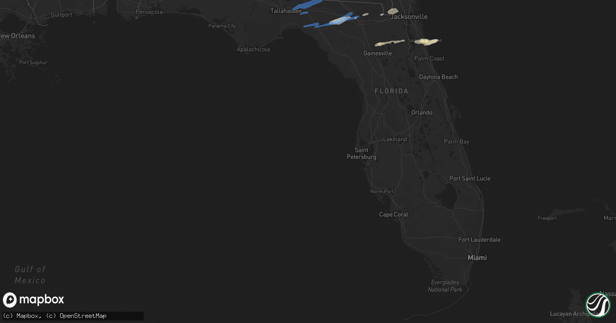
Hail Map in Florida on April 13, 2020
Get this storm
April 13 map
$229
one time, instant access
Download today. No call, no setup
Keep the $229
Bought the map and want the full workflow? Apply the entire $229 to a subscription within 7 days. None of it is wasted.
Every map, not just this one
This buys you this map. Subscription and you get every map we run, in the markets you choose from a few cities to whole states to nationwide. Plus real-time alerts the moment a storm fires.
Contact data
Name, contact info, occupancy, even credit band for addresses in the footprint. You go from where it hit to who to call.
Become the source they trust
Unlimited branding weather history reports on demand. You already have the documented answer ready for the property owner, and you are the one who showed up with it.
Property data and RoofTrace estimates
Pull up any address you have got, its value and the exact code rules for that jurisdiction, straight from One Click Code. Then RoofTrace estimates the squares, pitch, and roof value, priced the way you price.
Storm reports in Florida
Florida
| Date | Description |
|---|---|
| 04/13/20203:23 PM CDT | Tree down and blocking sr 100 in bradford county... Fl. |
| 04/13/20209:16 AM CDT | Widespread reports of trees and powerlines reported across suwannee county... Florida. |
| 04/13/20209:10 AM CDT | Suwannee county emergency management reports three damaged along u.s. Highway 90 just west of downtown live oak along goldkist boulevard. The roof of the farmers cooper |
| 04/13/20209:09 AM CDT | On the morning of april 13th... An ef-o tornado with max winds of 75 mph touched down on the nw side of live oak... Ga near the farmers coop. The tornado was approximat |
| 04/13/20209:09 AM CDT | An ef-0 tornado touched down just northeast of the suwannee county airport and moved east-northastward across u.s. Highway 90... Damaging three buildings adjacent to go |
| 04/13/20208:07 AM CDT | Tree down near boyd road and us-221. |
| 04/13/20208:04 AM CDT | 1 tree down near slaughter road. |
| 04/13/20207:57 AM CDT | At 1257 AM CDT, a severe thunderstorm was located 6 miles southwest of Gulf Breeze, moving northeast at 55 mph. HAZARD...60 mph wind gusts and quarter size hail. SOURCE...Radar indicated. IMPACT...Hail damage to vehicles is expected. Expect wind damage to roofs, siding, and trees. Locations impacted include... Warrington, Gulf Breeze, Oriole Beach, Navarre, Navarre Beach and Pensacola Beach. |
| 04/13/20207:07 AM CDT | Trees down on ashville highway as well as on brock road. Time estimated by radar. |
| 04/13/20207:06 AM CDT | Trees down on ashville highway and also on brock road. Time estimated by radar. |
| 04/13/20207:05 AM CDT | Numerous trees down on peter brown lane. Some trees snapped. |
| 04/13/20207:04 AM CDT | At 1203 AM CDT, a severe thunderstorm was located 9 miles southwest of New Brockton, or 9 miles south of Elba, moving northeast at 60 mph. Other strong storms are expected to intensify west of the area and move into the area over the next hour. HAZARD...60 mph wind gusts. SOURCE...Radar indicated. IMPACT...Expect damage to roofs, siding, and trees. Locations impacted include... Daleville, Elba, Geneva, Enterprise, Fort Rucker, Ozark, Level Plains, Samson, New Brockton, Ariton, Lee, Clayhatchee, Kinston, Coffee Springs, Carl Folsom A/p, Hooper Stage Field, Gerald, Camp Humming Hills, Cairns Aaf and Camp Alaflo Bsa. |
| 04/13/20204:38 AM CDT | At 937 AM EDT, Doppler radar indicated a line of severe thunderstorms capable of producing destructive winds in excess of 70 mph. These storms were located along a line extending from near Jasper to 25 miles south of St George Island, and moving east at 25 mph. Locations impacted include... Perry, Pinland, Jug Island, Buckville, Dekle Beach, Jack Lee Island, Foley, Salem, Perry-Foley Airport, Hampton Springs, Cedar Island, Fish Creek, Howell Place, Chancey, Secotan, Boyd, Smith, Carbur, Mayo Junction and Adams Beach. |
| 04/13/20204:13 AM CDT | At 913 AM EDT, a severe thunderstorm was located over Lake Park, moving northeast at 20 mph. HAZARD...60 mph wind gusts. SOURCE...Radar indicated. IMPACT...Expect damage to roofs, siding, and trees. Locations impacted include... Lake Park, I-75 At Exit 5, Twin Lakes and Clyattville. |
| 04/13/20204:08 AM CDT | At 908 AM EDT, severe thunderstorms were located along a line extending from 6 miles west of Woodbine to near Needmore, moving east at 60 mph. HAZARD...70 mph wind gusts and quarter size hail. SOURCE...Radar indicated. IMPACT...Hail damage to vehicles is expected. Expect considerable tree damage. Wind damage is also likely to mobile homes, roofs, and outbuildings. Locations impacted include... St. Marys, Kingsland, Brunswick, St. Simons Island, Hilliard, Folkston, Woodbine, Fargo, Statenville and Dock Junction. |
| 04/13/20203:42 AM CDT | At 842 AM EDT, Doppler radar indicated a line of severe thunderstorms capable of producing damaging winds in excess of 60 mph. These storms were located along a line extending from 8 miles southwest of Lake Park to 25 miles southwest of St George Island, and moving east at 25 mph. Locations impacted include... Madison, Perry, Greenville, Lee, Pinland, Jug Island, Ebb, Hamburg, Buckville, Pinetta, Eridu, Cabbage Grove, Scanlon, Lovett, Dekle Beach, Jack Lee Island, Foley, Salem, Hanson and Perry-Foley Airport. |
| 04/13/20203:41 AM CDT | At 840 AM EDT, a severe thunderstorm was located near Lake Park, moving northeast at 30 mph. HAZARD...70 mph wind gusts. SOURCE...Radar indicated. IMPACT...Expect considerable tree damage. Damage is likely to mobile homes, roofs, and outbuildings. Locations impacted include... Lake Park, Valdosta, Dasher, Naylor, I-75 At Exit 5, Greenwood, Twin Lakes, Clyattville, I-75 At Exit 11, Valdosta Regional Airport and Stockton. |
| 04/13/20203:35 AM CDT | At 835 AM EDT, severe thunderstorms were located along a line extending from near Needmore to near Jasper to 12 miles west of Dowling Park, moving northeast at 65 mph. HAZARD...60 mph wind gusts. SOURCE...Radar indicated. IMPACT...Expect damage to roofs, siding, and trees. Locations impacted include... Lake City, Live Oak, Jasper, Jennings, White Springs, Suwannee River State Park, Suwannee Springs, Winfield, Suwannee Valley and Belmont. |
| 04/13/20203:21 AM CDT | At 820 AM EDT, Doppler radar indicated a line of severe thunderstorms capable of producing damaging winds in excess of 60 mph. These storms were located along a line extending from 11 miles north of Madison to 29 miles southwest of St George Island, and moving east at 25 mph. Locations impacted include... Madison, Perry, Greenville, Lee, Pinland, Jug Island, Ebb, Hamburg, Buckville, Pinetta, Eridu, Cabbage Grove, Scanlon, Lovett, Dekle Beach, Jack Lee Island, Foley, Salem, Hanson and Perry-Foley Airport. |
| 04/13/20203:12 AM CDT | At 812 AM EDT, severe thunderstorms were located along a line extending from near Blackshear to 9 miles south of Manor to near Lake Park, moving northeast at 40 mph. HAZARD...60 mph wind gusts. SOURCE...Radar indicated. IMPACT...Expect damage to roofs, siding, and trees. Locations impacted include... Waycross, Blackshear, Folkston, Homerville, Nahunta, Fargo, Argyle, Statenville, Stephen Foster State Park and Homeland. |
| 04/13/20202:56 AM CDT | At 754 AM EDT, a severe thunderstorm was located over Valdosta, moving northeast at 30 mph. HAZARD...70 mph wind gusts. SOURCE...Radar indicated. IMPACT...Expect considerable tree damage. Damage is likely to mobile homes, roofs, and outbuildings. Locations impacted include... Lake Park, Lakeland, Quitman, Valdosta, Ray City, I-75 At Exit 16, Moody Air Force Base, Remerton, Meigs, Dasher, Grooverville, Barretts, Everett, Hansell, Nankin, Empress, Clyattville, Brooks Co A/p, I-75 At Exit 11 and Teeterville. |
| 04/13/20202:25 AM CDT | At 724 AM EDT/624 AM CDT/, Doppler radar indicated a line of severe thunderstorms capable of producing damaging winds in excess of 60 mph. These storms were located along a line extending from 6 miles northwest of Monticello to 16 miles southwest of Apalachicola, and moving east at 30 mph. Locations impacted include... Carrabelle, Monticello, Eastpoint, Apalachicola, Tallahassee, St. Marks, Woodville, Crawfordville, St George Island, Madison, Florida State University, Tallahassee Comm College, Doak Campbell Stadium, Florida A And M, Wakulla, Franklin, Greenville, Sopchoppy, Lake Bradford and Alma. |
| 04/13/20202:20 AM CDT | At 719 AM EDT, severe thunderstorms were located along a line extending from near Pebble Hill to near Quitman, moving east at 25 mph. HAZARD...60 mph wind gusts. SOURCE...Radar indicated. IMPACT...Expect damage to roofs, siding, and trees. Locations impacted include... Waycross, Blackshear, Homerville, Pearson, Nahunta, Jennings, Argyle, Statenville, Du Pont and Boggy Bay. |
| 04/13/20201:27 AM CDT | At 627 AM EDT, severe thunderstorms were located along a line extending from near Enigma to 6 miles northeast of Havana, moving southeast at 40 mph. HAZARD...60 mph wind gusts. SOURCE...Radar indicated. IMPACT...Expect damage to roofs, siding, and trees. Locations impacted include... Nashville, Adel, Thomasville, Lakeland, Valdosta, Lake Park, Quitman, Moultrie, Cairo, Hahira, Sparks, Boston, Enigma, Ray City, Lenox, Ochlocknee, Alapaha, Pavo, Coolidge and I-75 At Exit 16. |
| 04/12/202011:48 PM CDT | At 448 PM EDT, a severe thunderstorm was located near George's Lake, or 11 miles southwest of Green Cove Springs, moving east at 40 mph. HAZARD...60 mph wind gusts and quarter size hail. SOURCE...Radar indicated. IMPACT...Hail damage to vehicles is expected. Expect wind damage to roofs, siding, and trees. Locations impacted include... Saint Augustine, World Golf Village, Saint Augustine Beach, Vilano Beach, Picolata, Bostwick, Federal Point, Crescent Beach, Saint Augustine Shores and Butler Beach. |
| 04/12/202011:17 PM CDT | At 417 PM EDT, a severe thunderstorm was located near Starke, moving east at 35 mph. HAZARD...60 mph wind gusts and quarter size hail. SOURCE...Radar indicated. IMPACT...Hail damage to vehicles is expected. Expect wind damage to roofs, siding, and trees. Locations impacted include... Green Cove Springs, Keystone Heights and Penney Farms. |
| 04/12/202010:57 PM CDT | At 357 PM EDT, a severe thunderstorm was located 8 miles north of Gainesville Airport, or 10 miles north of Gainesville, moving northeast at 40 mph. HAZARD...60 mph wind gusts and quarter size hail. SOURCE...Radar indicated. IMPACT...Hail damage to vehicles is expected. Expect wind damage to roofs, siding, and trees. Locations impacted include... Starke, Sampson, Waldo, Hampton, La Crosse and Brooker. |
| 04/12/20209:22 PM CDT | At 222 AM CDT, a severe thunderstorm was located 11 miles northeast of De Funiak Springs, moving east at 55 mph. HAZARD...60 mph wind gusts and penny size hail. SOURCE...Radar indicated. IMPACT...Expect damage to roofs, siding, and trees. Locations impacted include... Panama City Beach, Vernon, Santa Rosa Beach, De Funiak Springs, Bonifay, Chipley, Graceville, Eglin Air Force Base, Bradford, Union, Liberty, Live Oak, Malone, Freeport, Cottondale, Ponce De Leon, Alford, Caryville, Wausau and Esto. |
| 04/12/20209:09 PM CDT | At 208 AM CDT, a severe thunderstorm was located over Geneva, moving northeast at 60 mph. HAZARD...60 mph wind gusts. SOURCE...Radar indicated. IMPACT...Expect damage to roofs, siding, and trees. Locations impacted include... Cottonwood, Dothan, Geneva, Hartford, Taylor, Kinsey, Ashford, Slocomb, Cowarts, Webb, Columbia, Malvern, Rehobeth, Avon, Madrid, Gordon, Coffee Springs, Black, Memphis and Kellys Crossroads. |
| 04/12/20208:55 PM CDT | At 155 AM CDT, severe thunderstorms were located along a line extending from 10 miles east of Crestview to 6 miles northwest of Valparaiso to 7 miles northeast of Navarre Beach, moving east at 60 mph. HAZARD...60 mph wind gusts. SOURCE...Radar indicated. IMPACT...Expect damage to roofs, siding, and trees. Locations impacted include... Wright, Fort Walton Beach, Niceville, Destin, Eglin AFB, Valparaiso, Mary Esther, Ocean City, Lake Lorraine, Shalimar and Cinco Bayou. |
| 04/12/20208:24 PM CDT | At 123 AM CDT, a severe thunderstorm was located 7 miles north of Eglin Air Force Base, or 10 miles west of De Funiak Springs, moving northeast at 45 mph. HAZARD...60 mph wind gusts and penny size hail. SOURCE...Radar indicated. IMPACT...Expect damage to roofs, siding, and trees. Locations impacted include... Santa Rosa Beach, De Funiak Springs, Eglin Air Force Base, Union, Liberty, Freeport, Paxton, Ponce De Leon, Oakwood Hills, Cluster Springs, Villa Tasso, Blue Mountain Beach, Seaside, Rock Hill, Glendale, Pleasant Ridge, Knox Hill, New Harmony, Piney Grove and Four Mile Village. |
| 04/12/20208:21 PM CDT | At 121 AM CDT, severe thunderstorms were located along a line extending from 7 miles southwest of Antioch to near Lockhart, moving east at 65 mph. HAZARD...60 mph wind gusts. SOURCE...Radar indicated. IMPACT...Expect damage to roofs, siding, and trees. Locations impacted include... Daleville, Elba, Geneva, Enterprise, Fort Rucker, Ozark, Hartford, Level Plains, Samson, Newton, New Brockton, Ariton, Lee, Clayhatchee, Kinston, Coffee Springs, Black, Carl Folsom A/p, Hooper Stage Field and Gerald. |
| 04/12/20208:18 PM CDT | At 118 AM CDT, a severe thunderstorm was located 12 miles east of Roeville, or 14 miles east of Bagdad, moving northeast at 60 mph. HAZARD...60 mph wind gusts and penny size hail. SOURCE...Radar indicated. IMPACT...Expect damage to roofs, siding, and trees. Locations impacted include... Wright, Crestview, Niceville, Eglin AFB, Valparaiso, Ocean City, Lake Lorraine, Baker and Shalimar. |
All States Impacted by Hail Map on April 13, 2020
Cities Impacted by Hail Map on April 13, 2020
- Hedgesville, WV
- Folkston, GA
- Gainesville, FL
- Saint Augustine, FL
- Elkton, FL
- Live Oak, FL
- Mayo, FL
- Lake City, FL
- Georgetown, SC
- Falling Waters, WV
- Martinsburg, WV
- Waldo, FL
- Lee, FL
- Sanderson, FL
- Glen Saint Mary, FL
- Catonsville, MD
- Dundalk, MD
- Baltimore, MD
- Halethorpe, MD
- Hampton, FL
- Big Pool, MD
- Bryceville, FL
- White Springs, FL
- Wellborn, FL
- Day, FL
- Keystone Heights, FL
- Starke, FL
- Green Cove Springs, FL
- Saint George, GA
- Berkeley Springs, WV
- Clear Spring, MD
- Hagerstown, MD
- Waretown, NJ
- Forked River, NJ
- Barnegat, NJ
- Windsor Mill, MD
- Pikesville, MD
- Gwynn Oak, MD
- Columbia, MD
- Clarksville, MD
- Woodstock, MD
- Ellicott City, MD
- Quantico, VA
- Triangle, VA
- Dumfries, VA
- Woodbridge, VA
- Manassas, VA
- Aspers, PA
- Williamsport, MD
- Biglerville, PA
- York New Salem, PA
- Rouzerville, PA
- Fayetteville, PA
- Hancock, MD
- York Springs, PA
- Greencastle, PA
- Cascade, MD
- Spring Grove, PA
- York, PA
- Quincy, PA
- Red Lion, PA
- East Berlin, PA
- Dover, PA
- Smithsburg, MD
- Maugansville, MD
- New Oxford, PA
- Abbottstown, PA
- Fairfield, PA
- State Line, PA
- Chambersburg, PA
- Littlestown, PA
- Waynesboro, PA
- Sabillasville, MD
- Mercersburg, PA
- Thomasville, PA
- Blue Ridge Summit, PA
- Seven Valleys, PA
- Hanover, PA
- Wrightsville, PA
- Windsor, PA
- McSherrystown, PA
- Mont Alto, PA
- Orrtanna, PA
- Gettysburg, PA
- Emmitsburg, MD
- Fairplay, MD
- Hampstead, MD
- Pequea, PA
- Shrewsbury, PA
- Felton, PA
- Holtwood, PA
- Millersville, PA
- Keymar, MD
- Sharpsburg, MD
- Christiana, PA
- New Freedom, PA
- Parkton, MD
- Woodsboro, MD
- Rohrersville, MD
- Lancaster, PA
- Brogue, PA
- Freeland, MD
- Shepherdstown, WV
- Airville, PA
- Gerrardstown, WV
- Westminster, MD
- Dallastown, PA
- Walkersville, MD
- Fawn Grove, PA
- Stewartstown, PA
- Quarryville, PA
- Strasburg, PA
- Union Bridge, MD
- Glenville, PA
- New Providence, PA
- Inwood, WV
- Thurmont, MD
- Glen Rock, PA
- Paradise, PA
- New Park, PA
- Middletown, MD
- Railroad, PA
- Taneytown, MD
- Willow Street, PA
- New Windsor, MD
- Myersville, MD
- Boonsboro, MD
- Washington Boro, PA
- Conestoga, PA
- Frederick, MD
- Drumore, PA
- Keedysville, MD
- Kearneysville, WV
- Manchester, MD
- Rocky Ridge, MD
- Berryville, VA
- Stephenson, VA
- Summit Point, WV
- Bunker Hill, WV
- Charles Town, WV
- Ranson, WV
- Clear Brook, VA
- Winchester, VA
- Edgewater, MD
- District Heights, MD
- Capitol Heights, MD
- Washington, DC
- Bowie, MD
- Springfield, VA
- Temple Hills, MD
- Alexandria, VA
- Riva, MD
- Hyattsville, MD
- Annapolis, MD
- Fort Belvoir, VA
- Suitland, MD
- Stevensville, MD
- Oxon Hill, MD
- Lorton, VA
- Harwood, MD
- Upper Marlboro, MD
- Davidsonville, MD
- Boyce, VA
- Stephens City, VA
- Star Tannery, VA
- White Post, VA
- Middletown, VA
- Strasburg, VA
- Front Royal, VA
- Conowingo, MD
- Finksburg, MD
- Mount Airy, MD
- Peach Bottom, PA
- Brunswick, MD
- New Market, MD
- Cochranville, PA
- Delta, PA
- Upperco, MD
- Street, MD
- Lovettsville, VA
- Kirkwood, PA
- Jefferson, MD
- Whiteford, MD
- Atglen, PA
- Ijamsville, MD
- Harpers Ferry, WV
- Monkton, MD
- Pylesville, MD
- White Hall, MD
- Oxford, PA
- Knoxville, MD
- Millville, WV
- Jarrettsville, MD
- Monrovia, MD
- Lincoln University, PA
- Reisterstown, MD
- Sparks Glencoe, MD
- Purcellville, VA
- Nottingham, PA
- Elmer, NJ
- Leesburg, VA
- Hanover, MD
- Church Hill, MD
- Hartly, DE
- Garrett Park, MD
- Jessup, MD
- Rockville, MD
- Harmans, MD
- Penns Grove, NJ
- Monroeville, NJ
- Clayton, DE
- Massey, MD
- Dickerson, MD
- Centreville, MD
- Barclay, MD
- Glen Burnie, MD
- Still Pond, MD
- Kensington, MD
- Crofton, MD
- Middletown, DE
- Worton, MD
- Crumpton, MD
- Arnold, MD
- Pennsville, NJ
- Millersville, MD
- Chestertown, MD
- Boyds, MD
- Germantown, MD
- Earleville, MD
- Savage, MD
- Silver Spring, MD
- Odenton, MD
- Laurel, MD
- Odessa, DE
- Townsend, DE
- Sterling, VA
- Warwick, MD
- Sudlersville, MD
- Annapolis Junction, MD
- Pasadena, MD
- Elkridge, MD
- Fort George G Meade, MD
- Great Falls, VA
- Bridgeton, NJ
- Potomac, MD
- Curtis Bay, MD
- Gambrills, MD
- Linthicum Heights, MD
- Galena, MD
- Gibson Island, MD
- Georgetown, MD
- Rock Hall, MD
- Derwood, MD
- Woodstown, NJ
- Port Penn, DE
- Alloway, NJ
- Smyrna, DE
- Severn, MD
- Crownsville, MD
- Burtonsville, MD
- Sparrows Point, MD
- Kennedyville, MD
- Poolesville, MD
- Bethesda, MD
- Beltsville, MD
- Millington, MD
- Spencerville, MD
- Marydel, MD
- Ashburn, VA
- Severna Park, MD
- Salem, NJ
- Fort Howard, MD
- Gaithersburg, MD
- Pedricktown, NJ
- College Park, MD
- Cooksville, MD
- Cockeysville, MD
- Joppa, MD
- Glen Arm, MD
- Hydes, MD
- Owings Mills, MD
- Havre De Grace, MD
- Fork, MD
- Fulton, MD
- Stevenson, MD
- Newark, DE
- Perryman, MD
- Upper Falls, MD
- Perryville, MD
- Aberdeen, MD
- Marriottsville, MD
- Lutherville Timonium, MD
- Rising Sun, MD
- White Marsh, MD
- Brooklyn, MD
- Glenelg, MD
- Betterton, MD
- Damascus, MD
- Delaware City, DE
- Middle River, MD
- Dayton, MD
- Elkton, MD
- Cecilton, MD
- Bear, DE
- Chesapeake City, MD
- Port Deposit, MD
- Perry Point, MD
- Baldwin, MD
- Sandy Spring, MD
- Brookeville, MD
- Brinklow, MD
- North East, MD
- Olney, MD
- Kingsville, MD
- Rosedale, MD
- Saint Georges, DE
- New Castle, DE
- West Friendship, MD
- Belcamp, MD
- Montgomery Village, MD
- Nottingham, MD
- Edgewood, MD
- Fallston, MD
- Perry Hall, MD
- Landenberg, PA
- Aberdeen Proving Ground, MD
- Randallstown, MD
- Abingdon, MD
- Parkville, MD
- Gunpowder, MD
- Glenwood, MD
- Highland, MD
- Towson, MD
- Elk Mills, MD
- Ashton, MD
- Phoenix, MD
- Wilmington, DE
- Bel Air, MD
- Charlestown, MD
- Churchville, MD
- Essex, MD
- Hockessin, DE
- Woodbine, MD
- Sykesville, MD
- Glyndon, MD
- Hunt Valley, MD
- Kennett Square, PA
- Forest Hill, MD
- Toughkenamon, PA
- West Grove, PA
- Darlington, MD
- Colora, MD
- Avondale, PA
- Marydel, DE
- Frederica, DE
- Mauricetown, NJ
- Avalon, NJ
- Greenwich, NJ
- Cordova, MD
- Villas, NJ
- Cape May Court House, NJ
- Viola, DE
- Wye Mills, MD
- Woodside, DE
- Cedarville, NJ
- Cape May, NJ
- Sea Isle City, NJ
- Leesburg, NJ
- Ridgely, MD
- Millville, NJ
- Wildwood, NJ
- Felton, DE
- Vineland, NJ
- Delmont, NJ
- Rio Grande, NJ
- Dover, DE
- Queen Anne, MD
- Newport, NJ
- Ingleside, MD
- Cheswold, DE
- Magnolia, DE
- Port Norris, NJ
- Shiloh, NJ
- Cape May Point, NJ
- Chester, MD
- Queenstown, MD
- Dorchester, NJ
- Dover Afb, DE
- Milford, DE
- Camden Wyoming, DE
- Goldsboro, MD
- Greensboro, MD
- Hillsboro, MD
- Port Elizabeth, NJ
- Heislerville, NJ
- Fortescue, NJ
- Henderson, MD
- Grasonville, MD
- Harrington, DE
- Denton, MD
- Woodbine, NJ
- Stone Harbor, NJ
- East Smithfield, PA
- Gillett, PA
- Lawton, PA
- Hallstead, PA
- Granville Summit, PA
- Columbia Cross Roads, PA
- Stevensville, PA
- Binghamton, NY
- Troy, PA
- Spencer, NY
- Forksville, PA
- Montrose, PA
- Wysox, PA
- Wyalusing, PA
- Le Raysville, PA
- Ulster, PA
- Sayre, PA
- Milan, PA
- Waverly, NY
- Castle Creek, NY
- Nichols, NY
- Newark Valley, NY
- Candor, NY
- Vestal, NY
- Conklin, NY
- Athens, PA
- Maine, NY
- Erin, NY
- Johnson City, NY
- Wellsburg, NY
- Monroeton, PA
- Canton, PA
- Lowman, NY
- Kirkwood, NY
- Rome, PA
- Warren Center, PA
- Chemung, NY
- Towanda, PA
- Barton, NY
- Elmira, NY
- Little Meadows, PA
- Brackney, PA
- New Albany, PA
- Owego, NY
- Friendsville, PA
- Lockwood, NY
- Apalachin, NY
- Van Etten, NY
- Endicott, NY
- Glen Aubrey, NY
- Monticello, FL
- Greenville, FL
- Lamont, FL
- Tallahassee, FL
- Lloyd, FL
- Quitman, GA
- Perry, FL
- Jasper, FL
- Lakeland, GA
- Naylor, GA
- Homerville, GA
- Fargo, GA
- Waycross, GA
- Morven, NC
- Sunset Beach, NC
- Andrews, SC
- Hemingway, SC
- Myrtle Beach, SC
- Calabash, NC
- Pawleys Island, SC
- Gresham, SC
- Murrells Inlet, SC
- Conway, SC
- North Myrtle Beach, SC
- Longs, SC
- Little River, SC
- Gastonia, NC
- Fort Mill, SC
- York, SC
- Sharon, SC
- McConnells, SC
- Pineville, NC
- Charlotte, NC
- Rock Hill, SC
- Belmont, NC
- Clover, SC
- Whiteville, NC
- Hallsboro, NC
- Kernersville, NC
- Colfax, NC
- Winston Salem, NC
- Cedar Grove, NC
- Graham, NC
- Rougemont, NC
- Hurdle Mills, NC
- Burlington, NC
- Timberlake, NC
- Mebane, NC
- Oxford, NC
- Roxboro, NC
- Efland, NC
- Haw River, NC
- Randleman, NC
- Sophia, NC
- Asheboro, NC
- Snow Camp, NC
- Hillsborough, NC
- Bolivia, NC
- Oak Island, NC
- Wilmington, NC
- Southport, NC
- Carolina Beach, NC
- Kure Beach, NC
- Staley, NC
- Siler City, NC
- Ramseur, NC
- Liberty, NC
- Franklinville, NC
- Sanford, NC
- Cameron, NC
- Zebulon, NC
- Fuquay Varina, NC
- Apex, NC
- Knightdale, NC
- Garner, NC
- Youngsville, NC
- Raleigh, NC
- Wake Forest, NC
- Rolesville, NC
- Wendell, NC
- Durham, NC
- Middleburg, NC
- Manson, NC
- Boydton, VA
- Kittrell, NC
- Franklinton, NC
- Warrenton, NC
- Creedmoor, NC
- Henderson, NC
- Norlina, NC
- Bracey, VA
- Hampstead, NC
- Rocky Point, NC
- Burgaw, NC
- Currie, NC
- Stedman, NC
- Wade, NC
- Dunn, NC
- Godwin, NC
- Fayetteville, NC
- Hope Mills, NC
- Autryville, NC
- Salisbury, NC
- Rockwell, NC
- China Grove, NC
- Concord, NC
- Kannapolis, NC
- Olin, NC
- Hamptonville, NC
- East Bend, NC
- Boonville, NC
- Union Grove, NC
- Yadkinville, NC
- Harmony, NC
- Statesville, NC
- Pfafftown, NC
- Lewisville, NC
- Blanchard, PA
- Cogan Station, PA
- Montgomery, PA
- Lock Haven, PA
- Bellefonte, PA
- Williamsport, PA
- Howard, PA
- Osceola Mills, PA
- Warriors Mark, PA
- Julian, PA
- Fleming, PA
- Tyrone, PA
- Milesburg, PA
- Dysart, PA
- Smithmill, PA
- Loganton, PA
- Mill Hall, PA
- Sandy Ridge, PA
- Blandburg, PA
- Jersey Shore, PA
- State College, PA
- Linden, PA
- Port Matilda, PA
- Avis, PA
- Houtzdale, PA
- Allenwood, PA
- Philipsburg, PA
- Orviston, PA
- Lamar, PA
- Beech Creek, PA
- Beccaria, PA
- Fallentimber, PA
- Coalport, PA
- Spruce Creek, PA
- Hollidaysburg, PA
- Madisonburg, PA
- Reedsville, PA
- Tipton, PA
- Lewisburg, PA
- Bellwood, PA
- Alexandria, PA
- Millmont, PA
- Huntingdon, PA
- Woodward, PA
- Millheim, PA
- Altoona, PA
- New Columbia, PA
- Rebersburg, PA
- Aaronsburg, PA
- Boalsburg, PA
- Petersburg, PA
- Centre Hall, PA
- Belleville, PA
- Laurelton, PA
- Ashville, PA
- Milroy, PA
- Lemont, PA
- Spring Mills, PA
- Duncansville, PA
- Williamsburg, PA
- Pennsylvania Furnace, PA
- Mifflinburg, PA
- Coburn, PA
- Pine Grove Mills, PA
- McVeytown, PA
- Selinsgrove, PA
- Beaver Springs, PA
- Mill Creek, PA
- McAlisterville, PA
- Allensville, PA
- Lewistown, PA
- Beavertown, PA
- Middleburg, PA
- Mifflintown, PA
- Granville, PA
- Mifflin, PA
- Freeburg, PA
- McClure, PA
- Yeagertown, PA
- Winfield, PA
- New Berlin, PA
- Burnham, PA
- Mays Landing, NJ
- Port Republic, NJ
- Absecon, NJ
- Tuckerton, NJ
- Pleasantville, NJ
- Beach Haven, NJ
- Egg Harbor City, NJ
- Egg Harbor Township, NJ


