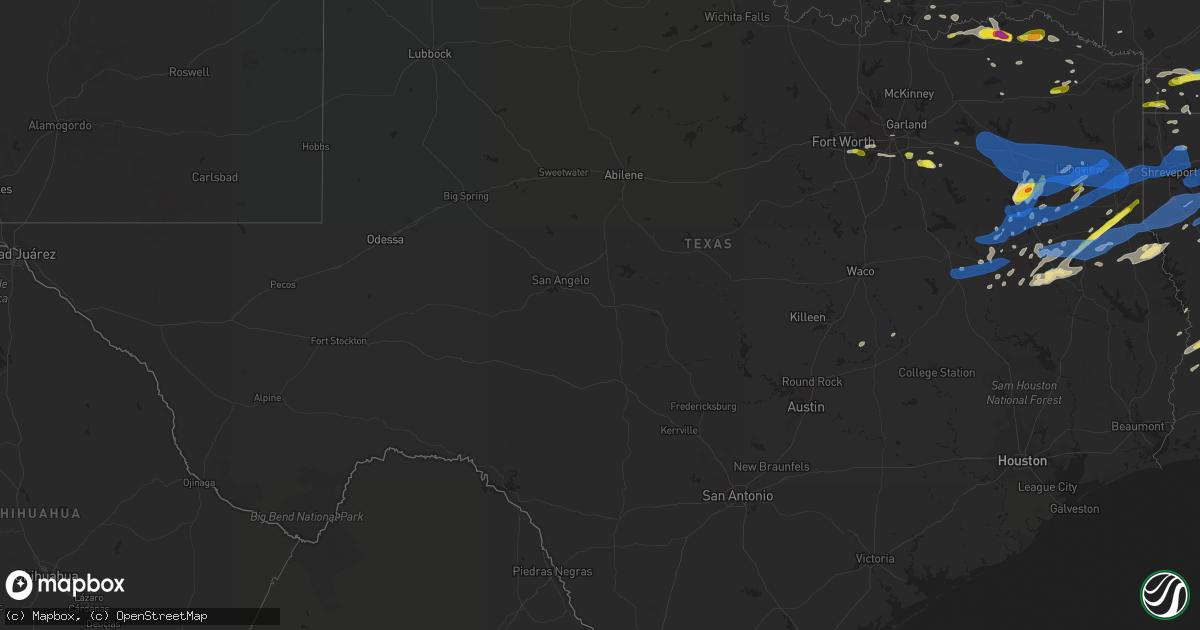
Hail Map in Texas on April 12, 2020
Get this storm
April 12 map
$229
one time, instant access
Download today. No call, no setup
Keep the $229
Bought the map and want the full workflow? Apply the entire $229 to a subscription within 7 days. None of it is wasted.
Every map, not just this one
This buys you this map. Subscription and you get every map we run, in the markets you choose from a few cities to whole states to nationwide. Plus real-time alerts the moment a storm fires.
Contact data
Name, contact info, occupancy, even credit band for addresses in the footprint. You go from where it hit to who to call.
Become the source they trust
Unlimited branding weather history reports on demand. You already have the documented answer ready for the property owner, and you are the one who showed up with it.
Property data and RoofTrace estimates
Pull up any address you have got, its value and the exact code rules for that jurisdiction, straight from One Click Code. Then RoofTrace estimates the squares, pitch, and roof value, priced the way you price.
Storm reports in Texas
Texas
| Date | Description |
|---|---|
| 04/12/20206:56 PM CDT | Trees and power lines down. Street signs blowing away. |
| 04/12/20206:55 PM CDT | Amateur radio reports a wind gust of 70 mph in the city of hawkins. |
| 04/12/20206:53 PM CDT | A 70+ ft black jack oak tree was blown down onto a shop on stallion road... Damaging the roof. |
| 04/12/20206:52 PM CDT | A 50 ft tall oak tree with a 16 inch wide trunk was blown down across the 5000 block of east lake drive in the union grove community. |
| 04/12/20206:49 PM CDT | Trees down near i-20 between highway 69 and highway 14... Near lavender road. |
| 04/12/20206:49 PM CDT | Large tree limbs were downed in mid town tyler. Power is out to the area. |
| 04/12/20206:45 PM CDT | Trees down near winona. |
| 04/12/20206:42 PM CDT | Multiple trees down near tyler pipe in the swan community. |
| 04/12/20206:40 PM CDT | 60 foot pine trees down at holly lake ranch. Power is out to the area. |
| 04/12/20206:30 PM CDT | Multiple large trees blown down and roof damage to a green house near fruitvale |
| 04/12/20206:28 PM CDT | Trees were downed on fm 16 west near hide-a-way lake. |
| 04/12/20206:14 PM CDT | Numerous trees down and several county roads blocked around emory. |
| 04/12/20205:45 PM CDT | Half dollar sized hail reported by red river county sheriffs office. |
| 04/12/20205:38 PM CDT | Brief half-dollar hail mixed with smaller hail in oak grove. |
| 04/12/20205:10 PM CDT | A local report indicates 1.00 inch wind near 8 N MOUNT PLEASANT |
| 04/12/20204:48 PM CDT | Trained spotter reports 2 inch hail 1 mile northeast of loop 286 on north side of town. |
| 04/12/20204:42 PM CDT | Lamar so relayed reports of half-dollar to ping pong ball size hail along fm1499 near fm1500. Approx 5 miles w of hwy 271. |
| 04/12/20204:40 PM CDT | Social media reports of near quarter size hail at cooper/hardisty st in arlington. |
| 04/12/20204:21 PM CDT | Quarter size hail on cr 34520 north of sumner. |
| 04/12/20203:17 PM CDT | Quarter hail in ivanhoe at 3:17 pm. |
| 04/12/20209:42 AM CDT | Trees down reported stricklin springs area. |
| 04/12/20209:37 AM CDT | Corrects previous tornado report from 2 se marshall. Large trees reported down... Some broken or snapped 9.2 se of marshall at fm 31 and crossroads. |
| 04/12/20209:37 AM CDT | Large trees reported down... Some broken or snapped 9.2 se of marshall at fm 31 and crossroads. |
| 04/12/20209:20 AM CDT | Small limbs broken. |
| 04/12/20209:18 AM CDT | Large tree uprooted. |
| 04/12/20209:17 AM CDT | Large branches broken. |
| 04/12/20209:14 AM CDT | Large tree uprooted. |
| 04/12/20209:14 AM CDT | Large branches broken. |
| 04/12/20209:14 AM CDT | Large limbs broken. |
| 04/12/20209:12 AM CDT | Large branches broken off of trees. |
| 04/12/20209:10 AM CDT | Trees uprooted with roof damage to a house. |
| 04/12/20209:10 AM CDT | Hardwood trees uprooted and snapped. |
| 04/12/20209:06 AM CDT | An ef-1 tornado briefly touched down in a primarily wooded area along county road 4037. Path length was 0.74 miles... Max width was 30 yards... And maximum estimated wi |
| 04/12/20208:35 AM CDT | Quarter size hail reported 2 miles south of gregg county airport. |
| 04/12/20208:15 AM CDT | Trees reported down on sabine street in south longview. |
| 04/12/20207:58 AM CDT | Delayed report of trees down near the intersection of farm-to-market road 321 and farm-to-market road 315 in the elmwood area just north of palestine. |
| 04/12/20207:57 AM CDT | At 1257 AM CDT, severe thunderstorms were located along a line extending from 7 miles east of Gail to near Greenwood, moving east at 35 mph. HAZARD...60 mph wind gusts and quarter size hail. SOURCE...Radar indicated. IMPACT...Hail damage to vehicles is expected. Expect wind damage to roofs, siding, and trees. Locations impacted include... Big Spring, Greenwood, Stanton, Lomax, J B Thomas Reservoir, Luther, Randalls Corner, Big Spring McMahon-Wrinkle Airpark, Knott, Knapp and Elbow.This includes Interstate 20 between mile markers 152 and 182. |
| 04/12/20207:54 AM CDT | At 1254 AM CDT, severe thunderstorms were located along a line extending from 15 miles southwest of Crane to 21 miles south of Fort Stockton, moving east at 25 mph. HAZARD...60 mph wind gusts and quarter size hail. SOURCE...Radar indicated. IMPACT...Hail damage to vehicles is expected. Expect wind damage to roofs, siding, and trees. Locations impacted include... Girvin.This includes Interstate 10 between mile markers 268 and 286. |
| 04/12/20207:53 AM CDT | At 1253 AM CDT, a severe thunderstorm was located 7 miles east of Comstock, moving northeast at 45 mph. HAZARD...Half dollar size hail. SOURCE...Radar indicated. IMPACT...Damage to vehicles is expected. Locations impacted include... Comstock, Loma Alta, Carta Valley, Devils Shores, Pafford Crossing, Spur 406 Campground, Vinegarone, Devils River State Nat Area Big Satan, Rough Canyon Recreation Area, and Devils River State Nat Area Del Norte. |
| 04/12/20207:35 AM CDT | Quarter size hail reported at nw part of loop 323 in tyler. |
| 04/12/20207:26 AM CDT | Golf ball size hail reported near tyler mall and at golden road and loop 323. |
| 04/12/20207:21 AM CDT | At 1221 AM CDT, severe thunderstorms were located along a line extending from 12 miles south of Midland International Air and Space Port to 11 miles northwest of Crane, moving east at 10 mph. HAZARD...60 mph wind gusts and quarter size hail. SOURCE...Radar indicated. IMPACT...Hail damage to vehicles is expected. Expect wind damage to roofs, siding, and trees. Locations impacted include... Midland, Crane, Cotton Flat, Crane County Airport, Spraberry, Skywest Airport and Cordona Lake. |
| 04/12/20207:16 AM CDT | At 1216 PM CDT, a severe thunderstorm was located 7 miles northwest of Tenaha, or 9 miles south of Carthage, moving northeast at 65 mph. HAZARD...60 mph wind gusts and quarter size hail. SOURCE...Radar indicated. IMPACT...Hail damage to vehicles is expected. Expect wind damage to roofs, siding, and trees. Locations impacted include... Shreveport, Carthage, Stonewall, Gary City, Keachi, Longstreet, Gloster, Keat Chie, Frierson, Caspiana, Front, Spring Ridge, Taylortown, Kingston, Midyett, Kickapoo, Keithville, Deadwood, Woods and Robson. |
| 04/12/20207:07 AM CDT | An anemometer recorded a 63 mph wind gust on the emerald bay portion of lake palestine. |
| 04/12/20207:06 AM CDT | Four inch branches broken off trees in malakoff. |
| 04/12/20204:20 AM CDT | At 920 AM CDT, severe thunderstorms were located along a line extending from 6 miles northeast of Tenaha to Center to near Martinsville, moving northeast at 90 mph. HAZARD...70 mph wind gusts and quarter size hail. SOURCE...Radar indicated. IMPACT...Hail damage to vehicles is expected. Expect considerable tree damage. Wind damage is also likely to mobile homes, roofs, and outbuildings. Locations impacted include... Center, Mansfield, Coushatta, Logansport, Tenaha, Joaquin, Converse, Neuville, Shelbyville, Oak Grove, Pleasant Hill, Martin, Huxley, South Mansfield, Grand Cane, Edgefield, Longstreet, Stanley, Carmel and Lake End. |
| 04/12/20204:15 AM CDT | At 914 AM CDT, severe thunderstorms were located along a line extending from Deberry to 10 miles south of Elysian Fields to 7 miles east of Carthage to 6 miles north of Tenaha, moving east at 60 mph. These are very dangerous storms. HAZARD...80 mph wind gusts and quarter size hail. SOURCE...Radar indicated. IMPACT...Flying debris will be dangerous to those caught without shelter. Mobile homes will be heavily damaged. Expect considerable damage to roofs, windows, and vehicles. Extensive tree damage and power outages are likely. Locations impacted include... Shreveport, Bossier City, Carthage, Mansfield, Haughton, Greenwood, Waskom, Stonewall, Ringgold, Doyline, Deberry, Elysian Fields, South Mansfield, Hall Summit, Keachi, Grand Cane, Edgefield, Longstreet, Keat Chie and Curtis. |
| 04/12/20204:12 AM CDT | At 912 AM CDT, severe thunderstorms were located along a line extending from 6 miles southwest of Smithland to near Karnack to 6 miles east of Marshall, moving east at 45 mph. HAZARD...70 mph wind gusts and penny size hail. SOURCE...Radar indicated. IMPACT...Expect considerable tree damage. Damage is likely to mobile homes, roofs, and outbuildings. Locations impacted include... Shreveport, Bossier City, Springhill, Vivian, Haughton, Greenwood, Blanchard, Benton, Cullen, Plain Dealing, Cotton Valley, Oil City, Sarepta, Doyline, Mooringsport, Hosston, Belcher, Gilliam, Eastwood and Fosters. |
| 04/12/20203:28 AM CDT | At 828 AM CDT, severe thunderstorms were located along a line extending from 6 miles northeast of Longview to near Hallsville to 8 miles northwest of Tatum, moving east at 45 mph. HAZARD...70 mph wind gusts and nickel size hail. SOURCE...Radar indicated. IMPACT...Expect considerable tree damage. Damage is likely to mobile homes, roofs, and outbuildings. Locations impacted include... Longview, Marshall, Hallsville, Waskom, Jefferson, Karnack, Woodlawn, Smithland, Berea, Harleton, Gray, Lakeport, Scottsville, Uncertain, Nesbitt, Darco, Leigh, Jonesville and Judson. |
| 04/12/20202:32 AM CDT | At 732 AM CDT, severe thunderstorms were located along a line extending from Coffee City to 8 miles southwest of Reese to near Palestine, moving northeast at 30 mph. These are very dangerous storms. HAZARD...80 mph wind gusts and quarter size hail. SOURCE...Radar indicated. IMPACT...Flying debris will be dangerous to those caught without shelter. Mobile homes will be heavily damaged. Expect considerable damage to roofs, windows, and vehicles. Extensive tree damage and power outages are likely. Locations impacted include... Jacksonville, Whitehouse, Rusk, Overton, Bullard, Troup, Alto, New London, Arp, Mount Selman, Ponta, Joinerville, Mixon, Turnertown, Reese, New Salem, Maydelle, New Summerfield, Gallatin and Reklaw. |
| 04/12/20202:29 AM CDT | At 728 PM CDT, a severe gust front was located along a line extending from 7 miles north of Berea to Woodlawn to 8 miles southwest of Marshall to 7 miles southwest of Tatum to near Turnertown, moving east at 60 mph. These severe winds are arriving well ahead of the thunderstorms. HAZARD...60 mph wind gusts. SOURCE...Radar indicated. IMPACT...Expect damage to roofs, siding, and trees. Locations impacted include... Shreveport, Bossier City, Marshall, Henderson, Carthage, Vivian, Haughton, Greenwood, Blanchard, Waskom, Jefferson, Benton, Stonewall, Logansport, Tatum, Tenaha, Timpson, Plain Dealing, Oil City and Beckville. |
| 04/12/20202:16 AM CDT | At 716 AM CDT, a severe thunderstorm was located near Buffalo, or 17 miles southeast of Fairfield, moving east at 40 mph. Another severe storm was located just north of Palestine...moving east and southeast at 40 mph. HAZARD...70 mph wind gusts and quarter size hail. SOURCE...Radar indicated. IMPACT...Hail damage to vehicles is expected. Expect considerable tree damage. Wind damage is also likely to mobile homes, roofs, and outbuildings. Locations impacted include... Palestine, Buffalo, Elkhart, Jewett and Oakwood. This includes Interstate 45 between mile markers 170 and 189. |
| 04/12/20202:03 AM CDT | At 702 AM CDT, a severe thunderstorm was located over Coffee City, or 14 miles west of Whitehouse, moving northeast at 45 mph. HAZARD...60 mph wind gusts and quarter size hail. SOURCE...Radar indicated. IMPACT...Hail damage to vehicles is expected. Expect wind damage to roofs, siding, and trees. Locations impacted include... Tyler, Longview, Jacksonville, Kilgore, Whitehouse, White Oak, Gladewater, Lindale, Overton, Bullard, Troup, Big Sandy, New London, Arp, Clarksville City, East Mountain, Mount Selman, Rosewood, Liberty City and Mixon. |
| 04/12/20201:55 AM CDT | At 654 PM CDT, a severe thunderstorm was located 8 miles southwest of Maud, or 14 miles south of New Boston, moving southeast at 35 mph. HAZARD...60 mph wind gusts and quarter size hail. SOURCE...Radar indicated. IMPACT...Hail damage to vehicles is expected. Expect wind damage to roofs, siding, and trees. Locations impacted include... Atlanta, Linden, Queen City, Rodessa, Bivins, Ravanna, McLeod, Kildare, Bloomburg, Douglassville, Marietta, Red Hill, Bryans Mill and Kiblah. |
| 04/12/20201:48 AM CDT | At 647 PM CDT, severe thunderstorms were located along a line extending from near Quitman to near Hawkins to Lindale to near Edom, moving east at 45 mph. The strongest winds may occur along a gust front well ahead of the thunderstorms. HAZARD...60 mph wind gusts and penny size hail. SOURCE...Radar indicated. IMPACT...Expect damage to roofs, siding, and trees. Locations impacted include... Tyler, Longview, Kilgore, White Oak, Gladewater, Gilmer, Mineola, Lindale, Hallsville, Overton, Quitman, Tatum, Big Sandy, Hawkins, Ore City, New London, Clarksville City, East Mountain, Harleton and Hainesville. |
| 04/12/20201:43 AM CDT | At 643 AM CDT, a severe thunderstorm was located 9 miles northeast of Fairfield Lake State Park, or 16 miles northeast of Fairfield, moving northeast at 35 mph. HAZARD...70 mph wind gusts. SOURCE...Radar indicated. IMPACT...Expect considerable tree damage. Damage is likely to mobile homes, roofs, and outbuildings. Locations impacted include... Athens, Chandler, Frankston, Brownsboro, Berryville, Coffee City, Poynor and Moore Station. |
| 04/12/20201:36 AM CDT | At 636 AM CDT, a severe thunderstorm was located over Malakoff, or 11 miles west of Athens, moving northeast at 35 mph. HAZARD...70 mph wind gusts. SOURCE...Radar indicated. IMPACT...Expect considerable tree damage. Damage is likely to mobile homes, roofs, and outbuildings. Locations impacted include... Athens, Malakoff, Eustace, Trinidad, Caney City, Payne Springs, Log Cabin, Murchison and Star Harbor. |
| 04/12/20201:19 AM CDT | At 619 PM CDT, a severe thunderstorm was located near Fouke, or 15 miles northeast of Atlanta, moving southeast at 40 mph. HAZARD...60 mph wind gusts and quarter size hail. SOURCE...Radar indicated. IMPACT...Hail damage to vehicles is expected. Expect wind damage to roofs, siding, and trees. Locations impacted include... Magnolia, Atlanta, Stamps, Waldo, Lewisville, McNeil, Queen City, Fouke, Bradley, Taylor, Emerson, Buckner, Garland, Bussey, Smithland, Brightstar, Canfield, Macedonia, Calhoun and Bloomburg. |
| 04/12/20201:11 AM CDT | At 611 PM CDT, a cluster of severe thunderstorms were located near Grand Saline, or 7 miles northeast of Canton, moving east at 50 mph. HAZARD...60 mph wind gusts. SOURCE...Trained weather spotters. IMPACT...Expect damage to roofs, siding, and trees. Locations impacted include... Canton, Wills Point, Grand Saline, Mabank, Van, Edgewood, Emory, Fruitvale, Edom and Purtis Creek State Park.This includes Interstate 20 between mile markers 515 and 542. |
| 04/12/202012:43 AM CDT | At 543 AM CDT, severe thunderstorms were located along a line extending from 6 miles southwest of Hubbard to near Mart to near Lott, moving east at 40 mph. HAZARD...70 mph wind gusts and quarter size hail. SOURCE...Radar indicated. IMPACT...Hail damage to vehicles is expected. Expect considerable tree damage. Wind damage is also likely to mobile homes, roofs, and outbuildings. Locations impacted include... Mexia, Marlin, Groesbeck, Teague, Fairfield, Mart, Wortham, Riesel, Coolidge, Lott, Golinda, Hallsburg, Fort Parker State Park, Fairfield Lake State Park, Thornton, Kosse, Leroy, Mount Calm, Tehuacana and Streetman.This includes Interstate 45 between mile markers 181 and 215. |
| 04/12/202012:39 AM CDT | At 539 PM CDT, a severe thunderstorm was located near Clarksville, moving east at 25 mph. HAZARD...60 mph wind gusts and half dollar size hail. SOURCE...Radar indicated. IMPACT...Hail damage to vehicles is expected. Expect wind damage to roofs, siding, and trees. Locations impacted include... Clarksville, Foreman, Idabel, Broken Bow, Arkinda, Avery, Annona, Haworth, Garvin, Eagletown, Moon, Cerrogordo, Beaverdams, Goodlake, Goodwater, Shinewell, America, Bokhoma, Farmers Hill and Almont. |
| 04/12/202012:34 AM CDT | At 534 AM CDT, a severe thunderstorm was located near Burnet, moving northeast at 45 mph. HAZARD...60 mph wind gusts. SOURCE...Radar indicated. IMPACT...Expect damage to roofs, siding, and trees. Locations impacted include... Burnet, Bertram, Joppa, Oatmeal, Shady Grove and Mahomet. |
| 04/11/202011:51 PM CDT | At 450 PM CDT, a severe thunderstorm was located near Blossom, or near Paris, moving east at 30 mph. HAZARD...Ping pong ball size hail and 60 mph wind gusts. SOURCE...Radar indicated. IMPACT...People and animals outdoors will be injured. Expect hail damage to roofs, siding, windows, and vehicles. Expect wind damage to roofs, siding, and trees. Locations impacted include... Clarksville, Bagwell, Manchester, Detroit, Silver City, Kanawha, Negley, Kiomatia, Albion and Woodland. |
| 04/11/202011:39 PM CDT | At 438 AM CDT, a severe thunderstorm was located over Buchanan Dam, moving northeast at 50 mph. HAZARD...60 mph wind gusts and nickel size hail. SOURCE...Radar indicated. IMPACT...Expect damage to roofs, siding, and trees. Locations impacted include... Burnet, Kingsland, Buchanan Dam, Buchanan Lake Village, Inks Lake State Park, Watson, Bluffton, Briggs, Lake Victor, Sunnylane, Joppa, Tow, Shady Grove and Longhorn Cavern State Park. |
| 04/11/202011:13 PM CDT | At 412 AM CDT, a severe thunderstorm was located near Pear Valley, or 18 miles northwest of Brady, moving northeast at 50 mph. HAZARD...60 mph wind gusts and half dollar size hail. SOURCE...Radar indicated. IMPACT...Hail damage to vehicles is expected. Expect wind damage to roofs, siding, and trees. This severe thunderstorm will be near... Lohn around 420 AM CDT. Waldrip around 425 AM CDT. Rockwood around 430 AM CDT. Mercury around 440 AM CDT. Winchell around 445 AM CDT. Brookesmith and Elm Grove around 450 AM CDT.Other locations impacted by this severe thunderstorm include Whon,Us-283 Near The Mcculloch-Coleman County Line, Milburn, Fife and Hall. |
| 04/11/202010:48 PM CDT | At 347 AM CDT, a severe thunderstorm was located over Hilda, or 12 miles southeast of Mason, moving east at 55 mph. HAZARD...60 mph wind gusts and quarter size hail. SOURCE...Radar indicated. IMPACT...Hail damage to vehicles is expected. Expect wind damage to roofs, siding, and trees. Locations impacted include... Burnet, Kingsland, Llano, Buchanan Dam, Gainesville, Buchanan Lake Village, Castell, Field Creek, Inks Lake State Park, Cherry Spring, Lone Grove, Bluffton, Valley Spring, Prairie Mountain, Baby Head, Stolz, Longhorn Cavern State Park, Oxford and Tow. |
| 04/11/202010:44 PM CDT | At 344 AM CDT, a severe thunderstorm was located near Ingram, or 7 miles northwest of Kerrville, moving east at 45 mph. HAZARD...60 mph wind gusts and quarter size hail. SOURCE...Radar indicated. IMPACT...Hail damage to vehicles is expected. Expect wind damage to roofs, siding, and trees. Locations impacted include... Kerrville, Fredericksburg, Ingram, Hunt, Stonewall, Luckenbach, Cain City, Old Tunnel State Park, Kerrville-Schreiner Park, Tivydale, Willow City, Rocky Hill, Waltonia, LBJ State Park, Bankersmith, Mountain Home, Hye, Blumenthal, Eckert and Crabapple. |
| 04/11/202010:36 PM CDT | At 335 AM CDT, a severe thunderstorm was located near Bend, or 16 miles west of Lampasas, moving northeast at 40 mph. HAZARD...65 mph wind gusts and quarter size hail. SOURCE...Radar indicated. IMPACT...Hail damage to vehicles is expected. Expect wind damage to roofs, siding, and trees. Locations impacted include... Copperas Cove, Lampasas, Kempner and Lometa. |
| 04/11/202010:36 PM CDT | At 336 AM CDT, a severe thunderstorm was located 7 miles west of Eden, or 21 miles northwest of Menard, moving northeast at 45 mph. HAZARD...Ping pong ball size hail and 60 mph wind gusts. SOURCE...Radar indicated. IMPACT...People and animals outdoors will be injured. Expect hail damage to roofs, siding, windows, and vehicles. Expect wind damage to roofs, siding, and trees. This severe thunderstorm will be near... Eden around 345 AM CDT. Millersview around 400 AM CDT. Salt Gap around 405 AM CDT.Other locations impacted by this severe thunderstorm include Us-83 Near The Menard-Concho County Line, The Intersection Of Ranch Road 1929 And RanchRoad 2134, The Intersection Of Us-87 And Ranch Road 2134, The Intersection Of Us-83 And Ranch Road 765 and Live Oak. |
| 04/11/202010:05 PM CDT | At 305 AM CDT, a severe thunderstorm was located 12 miles west of Kerr Wildlife Management Area, or 19 miles north of Leakey, moving northeast at 50 mph. HAZARD...60 mph wind gusts and half dollar size hail. SOURCE...Radar indicated. IMPACT...Hail damage to vehicles is expected. Expect wind damage to roofs, siding, and trees. Locations impacted include... Hunt, Mountain Home, Tivydale, Kerr Wildlife Management Area, Harper, I-10 Near The Kimble-Kerr County Line and The Intersection Of I-10 And Us 290. |
| 04/11/202010:02 PM CDT | At 301 AM CDT, a severe thunderstorm was located 16 miles northeast of Eldorado, moving east at 20 mph. HAZARD...60 mph wind gusts and quarter size hail. SOURCE...Radar indicated. IMPACT...Hail damage to vehicles is expected. Expect wind damage to roofs, siding, and trees. This severe thunderstorm will remain over mainly rural areas of northeastern Schleicher, southeastern Tom Green, northwestern Menard and southwestern Concho Counties, including the following locations... The Intersection Of Us-190 And Ranch Road 2084 and Adams. |
| 04/11/202010:01 PM CDT | At 301 AM CDT, severe thunderstorms were located along a line extending from 12 miles southwest of Broome to 18 miles south of Big Lake, moving east at 40 mph. HAZARD...60 mph wind gusts and penny size hail. SOURCE...Radar indicated. IMPACT...Expect damage to roofs, siding, and trees. Severe thunderstorms will be near... Water Valley around 320 AM CDT. Carlsbad around 330 AM CDT. Grape Creek around 340 AM CDT. San Angelo around 345 AM CDT. Orient around 355 AM CDT. Miles around 400 AM CDT.Other locations impacted by these severe thunderstorms include TheIntersection Of Us-190 And Ranch Road 1828, The Intersection Of Us 190 And Highway 163,Us-87 Near The Coke-Tom Green County Line, Us-67 Near The Irion-Tom Green County Line, Us-190 Near The Crockett-Sutton County Line and Harriet. |
| 04/11/20209:29 PM CDT | At 229 AM CDT, a severe thunderstorm was located near Barksdale, or 20 miles south of Rocksprings, moving northeast at 45 mph. HAZARD...60 mph wind gusts and half dollar size hail. SOURCE...Radar indicated. IMPACT...Hail damage to vehicles is expected. Expect wind damage to roofs, siding, and trees. Locations impacted include... Camp Wood, Vance, Barksdale, and Prade Ranch. |
| 04/11/20209:19 PM CDT | At 218 AM CDT, a severe thunderstorm was located near Iraan, or 18 miles south of Rankin, moving east at 20 mph. HAZARD...60 mph wind gusts. SOURCE...Radar indicated. IMPACT...Expect damage to roofs, siding, and trees. This severe thunderstorm will remain over mainly rural areas of north central Crockett County. |
| 04/11/20209:16 PM CDT | At 216 AM CDT, severe thunderstorms were located along a line extending from 19 miles southeast of Rankin to 15 miles southwest of Sheffield, moving east at 35 mph. HAZARD...60 mph wind gusts and quarter size hail. SOURCE...Radar indicated. IMPACT...Hail damage to vehicles is expected. Expect wind damage to roofs, siding, and trees. Locations impacted include... Sheffield, Iraan and Iraan Municipal Airport. This includes Interstate 10 between mile markers 310 and 327. |
| 04/11/20209:04 PM CDT | At 204 AM CDT, severe thunderstorms were located along a line extending from 8 miles northeast of Garden City to 22 miles north of Reagan County Airport to 18 miles southeast of Rankin, moving east at 35 mph. HAZARD...Ping pong ball size hail and 60 mph wind gusts. SOURCE...Radar indicated. IMPACT...People and animals outdoors will be injured. Expect hail damage to roofs, siding, windows, and vehicles. Expect wind damage to roofs, siding, and trees. Locations impacted include... Big Lake, Garden City, Reagan County Airport, Best, Saint Lawrence and Stiles. |
| 04/11/20209:01 PM CDT | At 201 AM CDT, a severe thunderstorm was located over Loma Alta, moving northeast at 40 mph. HAZARD...60 mph wind gusts and half dollar size hail. SOURCE...Radar indicated. IMPACT...Hail damage to vehicles is expected. Expect wind damage to roofs, siding, and trees. Locations impacted include... Loma Alta, Vinegarone, and Devils River State Nat Area Del Norte. |
| 04/11/20208:58 PM CDT | At 158 AM CDT, a severe thunderstorm was located 9 miles west of Eldorado, moving northeast at 50 mph. HAZARD...60 mph wind gusts and half dollar size hail. SOURCE...Radar indicated. IMPACT...Hail damage to vehicles is expected. Expect wind damage to roofs, siding, and trees. This severe thunderstorm will be near... Eldorado around 210 AM CDT.Other locations impacted by this severe thunderstorm include TheIntersection Of Ranch Road 1828 And Ranch Road 915, The IntersectionOf Us-190 And Ranch Road 1828, The Intersection Of Us-190 And Ranch Road 2084 and Adams. |
| 04/11/20208:53 PM CDT | At 153 AM CDT, a severe thunderstorm was located 14 miles northeast of Carta Valley, or 17 miles east of Loma Alta, moving east at 65 mph. HAZARD...Golf ball size hail and 60 mph wind gusts. SOURCE...Radar indicated. IMPACT...People and animals outdoors will be injured. Expect hail damage to roofs, siding, windows, and vehicles. Expect wind damage to roofs, siding, and trees. Locations impacted include... Rocksprings, Devil's Sinkhole State Natural Area, and Prade Ranch. |
| 04/11/20208:34 PM CDT | At 134 AM CDT, severe thunderstorms were located along a line extending from 9 miles west of Snyder to 9 miles southeast of Lomax, moving east at 25 mph. HAZARD...60 mph wind gusts and quarter size hail. SOURCE...Radar indicated. IMPACT...Hail damage to vehicles is expected. Expect wind damage to roofs, siding, and trees. Locations impacted include... Big Spring, Snyder, Colorado City, Coahoma, Loraine, Forsan, Sand Springs, Lomax, Lake Colorado City, Lake Colorado City State Park, Inadale, Colorado City Airport, J B Thomas Reservoir, Champion Creek Reservoir, Westbrook, Cuthbert, Dunn, Big Spring McMahon-Wrinkle Airpark, Elbow and Vincent.This includes Interstate 20 between mile markers 169 and 228. |
| 04/11/20208:28 PM CDT | At 128 AM CDT, a severe thunderstorm was located over Bakersfield, moving east at 30 mph. HAZARD...60 mph wind gusts and quarter size hail. SOURCE...Radar indicated. IMPACT...Hail damage to vehicles is expected. Expect wind damage to roofs, siding, and trees. This severe thunderstorm will remain over mainly rural areas of northwestern Crockett County.This includes Interstate 10 near Mile Marker 327. |
| 04/11/20208:22 PM CDT | At 122 AM CDT, severe thunderstorms were located along a line extending from near McCamey to 30 miles southeast of Fort Stockton, moving east at 40 mph. HAZARD...60 mph wind gusts and quarter size hail. SOURCE...Radar indicated. IMPACT...Hail damage to vehicles is expected. Expect wind damage to roofs, siding, and trees. Locations impacted include... McCamey, Sheffield, Iraan, Iraan Municipal Airport, Upton County Airport, Bakersfield and Girvin.This includes Interstate 10 between mile markers 281 and 327. |
| 04/11/20208:13 PM CDT | At 113 AM CDT, severe thunderstorms were located along a line extending from 10 miles southeast of Greenwood to 9 miles south of Crane, moving east at 45 mph. HAZARD...60 mph wind gusts and quarter size hail. SOURCE...Radar indicated. IMPACT...Hail damage to vehicles is expected. Expect wind damage to roofs, siding, and trees. Locations impacted include... Rankin, Garden City, Saint Lawrence, Spraberry, King Mountain and Midkiff. |
| 04/11/20208:07 PM CDT | At 106 AM CDT, a severe thunderstorm was located 9 miles southwest of Ozona, moving northeast at 35 mph. HAZARD...60 mph wind gusts and quarter size hail. SOURCE...Radar indicated. IMPACT...Hail damage to vehicles is expected. Expect wind damage to roofs, siding, and trees. This severe thunderstorm will be near... Ozona around 125 AM CDT.Other locations impacted by this severe thunderstorm include Us-190 Near The Crockett-Sutton County Line and I-10 Near The Crockett-Sutton County Line.This includes Interstate 10 between Mile Markers 355 and 379. |
| 04/11/20207:20 PM CDT | A local report indicates 70 MPH wind near ATLANTA |
| 04/11/20207:12 PM CDT | Trees and power lines were downed in the new london area from a damaging gust front. |
| 04/11/20207:02 PM CDT | *** 1 fatal *** large tree fell on individual causing a fatal injury. |
All States Impacted by Hail Map on April 12, 2020
Cities Impacted by Hail Map on April 12, 2020
- Rayville, LA
- Epps, LA
- Pioneer, LA
- Delhi, LA
- Monroe, LA
- Burkeville, TX
- Boaz, AL
- Pinola, MS
- Magee, MS
- Mendenhall, MS
- Raleigh, MS
- McRae Helena, GA
- Milan, GA
- Covington, LA
- Springfield, LA
- Robert, LA
- Ponchatoula, LA
- Folsom, LA
- Loranger, LA
- Hammond, LA
- Deridder, LA
- Rocky Ford, GA
- Sylvania, GA
- Kilgore, TX
- Longview, TX
- Gordo, AL
- Knoxville, AL
- Aliceville, AL
- Eutaw, AL
- Ralph, AL
- Mountainburg, AR
- Rudy, AR
- Alma, AR
- Roxton, TX
- Hardeeville, SC
- Henderson, TX
- Colquitt, GA
- Gonzales, LA
- Baton Rouge, LA
- Prairieville, LA
- Douglass, TX
- Allen, OK
- Noxapater, MS
- Louisville, MS
- Sikes, LA
- Cameron, TX
- Merryville, LA
- Lumberton, MS
- Purvis, MS
- Saint Martinville, LA
- New Iberia, LA
- Jeanerette, LA
- Loreauville, LA
- Hampton, AR
- Kosciusko, MS
- Pickens, MS
- Lexington, MS
- Durant, MS
- Columbia, LA
- Grayson, LA
- Pelsor, AR
- Dover, AR
- Wanette, OK
- Macomb, OK
- Berry, AL
- Echola, AL
- Elrod, AL
- Northport, AL
- El Dorado, AR
- West Monroe, LA
- Eros, LA
- Chatham, LA
- Calipatria, CA
- Stuttgart, AR
- Troy, AL
- Gallant, AL
- Altoona, AL
- Attalla, AL
- Davis, OK
- Wynnewood, OK
- Fort Smith, AR
- Watson, AR
- Monticello, AR
- Statesboro, GA
- Winnfield, LA
- Peterman, AL
- Coushatta, LA
- Pineland, SC
- Frankston, TX
- Brantley, AL
- Louann, AR
- Camden, AR
- Trion, GA
- Summerville, GA
- Palestine, TX
- Crockett, TX
- Grapeland, TX
- Walker, LA
- Dacula, GA
- Braselton, GA
- Auburn, GA
- Buford, GA
- Lawrenceville, GA
- Flowery Branch, GA
- Hoschton, GA
- McLain, MS
- Perkinston, MS
- Bogalusa, LA
- Carrollton, AL
- Buhl, AL
- Fayette, AL
- Reform, AL
- Coker, AL
- Kennedy, AL
- Shelbyville, TX
- Brandon, MS
- Ridgeland, MS
- Madison, MS
- Jackson, MS
- Maysville, OK
- Lindsay, OK
- Satartia, MS
- Center, TX
- Newellton, LA
- Tallulah, LA
- Saline, LA
- Jonesboro, LA
- Goldonna, LA
- Clayton, AL
- Eufaula, AL
- Shorterville, AL
- Abbeville, AL
- Clopton, AL
- Timpson, TX
- Cushing, TX
- Rusk, TX
- Alto, TX
- Smithdale, MS
- Liberty, MS
- Harrisville, MS
- Braxton, MS
- Sorrento, LA
- Kennard, TX
- Wayne, OK
- Purcell, OK
- Harrisonburg, LA
- Calhoun, LA
- Natchitoches, LA
- Lewisville, AR
- Desoto, TX
- Lancaster, TX
- Dallas, TX
- Duncanville, TX
- Cedar Hill, TX
- Flint, TX
- Tyler, TX
- Whitehouse, TX
- Thomasville, AL
- Clayton, LA
- Detroit, TX
- Bagwell, TX
- Steele, AL
- Remlap, AL
- Oneonta, AL
- Flora, MS
- Scurry, TX
- Kaufman, TX
- Colfax, LA
- Ratcliff, AR
- Ozark, AR
- Downsville, LA
- Farmerville, LA
- Elkhart, TX
- Tuscumbia, AL
- Talco, TX
- Seagoville, TX
- Ferris, TX
- Arnaudville, LA
- Sallis, MS
- Wills Point, TX
- Terrell, TX
- Franklinton, LA
- McNeil, AR
- Buckner, AR
- Waldo, AR
- Banks, AR
- Stamps, AR
- Stephens, AR
- Blossom, TX
- Pine Valley, CA
- Campo, CA
- Boulevard, CA
- Calvin, OK
- Bay Springs, MS
- Heidelberg, MS
- Laurel, MS
- Pinson, AL
- Morris, AL
- Cleveland, AL
- Mount Olive, AL
- Trafford, AL
- Locust Fork, AL
- Gardendale, AL
- Graysville, AL
- Poplarville, MS
- Ohatchee, AL
- Paris, TX
- Sumner, TX
- Nacogdoches, TX
- Tenaha, TX
- Mount Enterprise, TX
- Gary, TX
- Carthage, TX
- Garrison, TX
- Laughlin, NV
- Searchlight, NV
- Scooba, MS
- Hartshorne, OK
- Collins, MS
- Texarkana, AR
- Fouke, AR
- Sulphur, OK
- Canton, MS
- Dardanelle, AR
- Pottsville, AR
- Russellville, AR
- Atkins, AR
- Mount Pleasant, TX
- Tifton, GA
- Enigma, GA
- Buckholts, TX
- Wells, TX
- Clarksville, TX
- Cecil, AR
- Highland Home, AL
- Goshen, AL
- Luverne, AL
- Grady, AL
- Rutledge, AL
- Donaldsonville, LA
- Belle Rose, LA
- Plattenville, LA
- Fort Scott, KS
- Uniontown, KS
- Taylor, AR
- Mer Rouge, LA
- Bastrop, LA
- Kenefic, OK
- Durant, OK
- Bassfield, MS
- Prentiss, MS
- Estill, SC
- Millen, GA
- Garfield, GA
- Tishomingo, OK
- Milburn, OK
- Ashdown, AR
- McGehee, AR
- Tillar, AR
- Troup, TX
- Metter, GA
- Kaplan, LA
- Lamar, AR
- White Oak, TX
- Gladewater, TX
- Trout, LA
- Abbeville, GA
- Eastman, GA
- McCool, MS
- Philadelphia, MS
- Preston, MS
- Brooksville, MS
- Macon, MS
- Shuqualak, MS
- Claxton, GA
- Woodville, MS
- Samson, AL
- Kinston, AL
- Olla, LA
- Haughton, LA
- Benton, LA
- Collins, GA
- Lyons, GA
- Mulberry, AR
- Dyer, AR
- Booneville, AR
- Greenwood, AR
- Robeline, LA
- Holden, LA
- Livingston, LA
- French Settlement, LA
- De Kalb, TX
- Avery, TX
- Brookston, TX
- Honey Grove, TX
- Arthur City, TX
- Mapleton, KS
- Altheimer, AR
- Wabbaseka, AR
- Silver City, MS
- Alex, OK
- Blanchard, OK
- Jacksonville, TX
- Leakesville, MS
- Guild, TN
- Trenton, GA
- Ethelsville, AL
- Edwards, MS
- Starkville, MS
- Lena, MS
- Camden, MS
- Bolton, MS
- Morton, MS
- Oakman, AL
- Raymond, MS
- Columbus, MS
- Clinton, MS
- Carthage, MS
- Crawford, MS
- Tuscaloosa, AL
- Arlington, TX
- Kennedale, TX
- Fort Worth, TX
- Scott, LA
- Lafayette, LA
- Carencro, LA
- Duson, LA
- Breaux Bridge, LA
- Rayne, LA
- Morse, LA
- Gueydan, LA
- Crowley, LA
- Magnolia, MS
- Pollock, LA
- Dry Prong, LA
- Georgetown, LA
- Tullos, LA
- Millport, AL
- Lake Providence, LA
- Opp, AL
- Dickinson, AL
- Grove Hill, AL
- Vicksburg, MS
- Garland, KS
- Farlington, KS
- Arcadia, KS
- Red Oak, OK
- Carnesville, GA
- Boulder City, NV
- Muscle Shoals, AL
- Haynesville, LA
- Junction City, AR
- Quincy, FL
- Ramer, AL
- Port Allen, LA
- Apison, TN
- McDonald, TN
- Cleveland, TN
- Tupelo, OK
- Ridgeland, SC
- Carville, LA
- Geismar, LA
- Maurepas, LA
- Saint Gabriel, LA
- Albany, LA
- Denham Springs, LA
- Saint Amant, LA
- White Castle, LA
- Independence, LA
- Tickfaw, LA
- Carson, MS
- Seminary, MS
- Taylorsville, MS
- Bullard, TX
- Lowndesboro, AL
- Glenwood, AL
- Powderly, TX
- Silver Creek, MS
- Campti, LA
- Florala, AL
- Rush Springs, OK
- Fosters, AL
- Atoka, OK
- Bay Saint Louis, MS
- Stennis Space Center, MS
- Cataula, GA
- Twin City, GA
- Springville, AL
- Kimberly, AL
- Warrior, AL
- Birmingham, AL
- Portal, GA
- Mansfield, LA
- Pelican, LA
- Chauncey, GA
- Amite, LA
- Greensburg, LA
- Pine Grove, LA
- Humphrey, AR
- Bennington, OK
- Bokchito, OK
- Converse, LA
- Letohatchee, AL
- Hayneville, AL
- Benton, MS
- Tishomingo, MS
- Dennis, MS
- Ada, OK
- Grand Chenier, LA
- Maurice, LA
- Bradley, SC
- Rainbow City, AL
- Mayersville, MS
- Rolling Fork, MS
- Calion, AR
- Darrow, LA
- Townley, AL
- Marshallville, GA
- Booneville, MS
- Nauvoo, AL
- Shelby, MS
- Calera, OK
- Hendrix, OK
- Greenville, AL
- Mccomb, MS
- Tylertown, MS
- Summit, MS
- Jayess, MS
- Ruth, MS
- Oakwood, TX
- West, MS
- Vaiden, MS
- Tennille, GA
- Garnett, SC
- Clinton, LA
- Norwood, LA
- Hayden, AL
- Marthaville, LA
- Vaughan, MS
- Choudrant, LA
- Springer, OK
- Springfield, AR
- Hattieville, AR
- Solgohachia, AR
- Morrilton, AR
- Caddo, OK
- Lucedale, MS
- Wiggins, MS
- Doddridge, AR
- Sulphur Springs, TX
- Early Branch, SC
- Varnville, SC
- Fitzpatrick, AL
- Hattiesburg, MS
- Emerson, AR
- Hope Hull, AL
- Prattville, AL
- Montgomery, AL
- Bullhead City, AZ
- Rossville, GA
- Ringgold, GA
- Fort Oglethorpe, GA
- Singer, LA
- Sondheimer, LA
- La Place, LA
- Bradley, AR
- Harrell, AR
- Jersey, AR
- Garland City, AR
- Rosston, AR
- Thornton, AR
- Ozark, AL
- Skipperville, AL
- Rochelle, GA
- McCune, KS
- Houston, MS
- McIntyre, GA
- Toomsboro, GA
- Ivanhoe, TX
- Ravenna, TX
- Madill, OK
- Fort Valley, GA
- Chattanooga, TN
- Chickasha, OK
- Tillman, SC
- Altus, AR
- Clarksville, AR
- Adger, AL
- Albertville, AL
- Mulga, AL
- Quinton, AL
- Horton, AL
- Dawson, AL
- Crossville, AL
- Brookside, AL
- Bessemer, AL
- Adamsville, AL
- Blountsville, AL
- Geraldine, AL
- Dora, AL
- Ashville, AL
- Lincoln, AL
- Anniston, AL
- Brawley, CA
- Pembroke, GA
- Buckatunna, MS
- Millry, AL
- State Line, MS
- Yazoo City, MS
- Mound Valley, KS
- Parsons, KS
- Wilburton, OK
- Cherokee, AL
- Pollok, TX
- Ethel, MS
- Bentonia, MS
- Perry, GA
- Picayune, MS
- Lavaca, AR
- Carriere, MS
- Humnoke, AR
- Gadsden, AL
- Cooper, TX
- Marietta, TX
- Douglassville, TX
- Naples, TX
- Lapine, AL
- Honoraville, AL
- Sardis, MS
- Jackson, AL
- Sunflower, AL
- Leroy, AL
- McIntosh, AL
- Deer Park, AL
- Gainestown, AL
- Wagarville, AL
- Pearl River, LA
- Altamont, KS
- Chatom, AL
- Beaumont, MS
- Gaylesville, AL
- Odenville, AL
- Goodman, MS
- Gilbert, LA
- Winnsboro, LA
- Mathews, AL
- Tougaloo, MS
- Enterprise, LA
- Fort Gaines, GA
- Elba, AL
- Valley Park, MS
- Register, GA
- Annona, TX
- Hampton, SC
- Coffeyville, KS
- Jesup, GA
- McKenzie, AL
- Red Level, AL
- Springhill, LA
- Soperton, GA
- Swainsboro, GA
- Bristow, OK
- Oak Grove, LA
- Natchez, LA
- Cloutierville, LA
- Montgomery, LA
- Hornbeck, LA
- Plain Dealing, LA
- Oak Ridge, LA
- Fort Necessity, LA
- Lena, LA
- Atlanta, LA
- Beatrice, AL
- Vredenburgh, AL
- Pocola, OK
- Hartman, AR
- Coal Hill, AR
- Arp, TX
- Winona, TX
- Sumrall, MS
- Soso, MS
- Mount Olive, MS
- Dalton, GA
- Oak Vale, MS
- Baker, LA
- Greenwell Springs, LA
- Zachary, LA
- Pride, LA
- Petersburg, TX
- Slaughter, LA
- Cement, OK
- Anadarko, OK
- Mill Creek, OK
- Homer, GA
- Transylvania, LA
- Cary, MS
- Fletcher, OK
- Elgin, OK
- Duncan, MS
- Snow Lake, AR
- Mangham, LA
- Baskin, LA
- Caney, OK
- Mcloud, OK
- Tecumseh, OK
- Chatsworth, GA
- Cookville, TX
- Crandall, TX
- Charleston, AR
- Nettleton, MS
- Okolona, MS
- Shannon, MS
- Plantersville, MS
- Fulton, MS
- England, AR
- Westmorland, CA
- Minden, LA
- Ruleville, MS
- Tucker, AR
- Carbon Hill, AL
- Eldridge, AL
- Bankston, AL
- Seabrook, SC
- Springfield, GA
- Kiln, MS
- Slidell, LA
- Monticello, MS
- Richton, MS
- Telephone, TX
- La Fayette, GA
- Neely, MS
- Brooklyn, MS
- Sicily Island, LA
- Eastaboga, AL
- Pell City, AL
- Riverside, AL
- Ragland, AL
- Grand Prairie, TX
- Monroeville, AL
- Franklin, AL
- Deport, TX
- Pattonville, TX
- Paoli, OK
- Fort Payne, AL
- Collinsville, AL
- Price, TX
- Delaware, AR
- Knoxville, AR
- London, AR
- Magazine, AR
- Paris, AR
- Scranton, AR
- New Blaine, AR
- Subiaco, AR
- Danville, AR
- Casa, AR
- Waldron, AR
- Houston, AR
- Blue Mountain, AR
- Belleville, AR
- Perry, AR
- Perryville, AR
- Havana, AR
- Ola, AR
- Plumerville, AR
- Adona, AR
- Magnolia, AR
- Smackover, AR
- Mount Holly, AR
- Hot Springs National Park, AR
- Malvern, AR
- Traskwood, AR
- Ozone, AR
- El Paso, AR
- Vilonia, AR
- Potts Camp, MS
- Grady, AR
- Coahoma, MS
- Thaxton, MS
- Sledge, MS
- Marks, MS
- Ethel, AR
- Batesville, MS
- Pine Bluff, AR
- Holly Springs, MS
- Nesbit, MS
- Senatobia, MS
- Etta, MS
- Almyra, AR
- Myrtle, MS
- Lyon, MS
- Ashland, MS
- Saint Charles, AR
- Clarksdale, MS
- Waterford, MS
- Holly Grove, AR
- Olive Branch, MS
- Hickory Flat, MS
- Courtland, MS
- Mellwood, AR
- Lambert, MS
- Gillett, AR
- University, MS
- Abbeville, MS
- Blue Mountain, MS
- Crenshaw, MS
- Taylor, MS
- Coldwater, MS
- Hernando, MS
- Como, MS
- Red Banks, MS
- Oxford, MS
- New Albany, MS
- Byhalia, MS
- Elaine, AR
- De Witt, AR
- Belden, MS
- Star City, AR
- Tichnor, AR
- Gould, AR
- Crumrod, AR
- Enid, MS
- Alligator, MS
- Ecru, MS
- Yorktown, AR
- Randolph, MS
- Pope, MS
- Blue Springs, MS
- Water Valley, MS
- Vance, MS
- Oakland, MS
- Paris, MS
- Pontotoc, MS
- Marvell, AR
- Clarendon, AR
- Aubrey, AR
- Ulm, AR
- Scott, AR
- Casscoe, AR
- Dundee, MS
- Helena, AR
- Lonoke, AR
- Marianna, AR
- De Valls Bluff, AR
- West Helena, AR
- Hazen, AR
- Tunica, MS
- Carlisle, AR
- Roe, AR
- Poplar Grove, AR
- Lexa, AR
- Brinkley, AR
- Des Arc, AR
- Wheatley, AR
- Griffithville, AR
- Searcy, AR
- Biscoe, AR
- Robinsonville, MS
- Moro, AR
- Brickeys, AR
- Augusta, AR
- Itta Bena, MS
- Calhoun City, MS
- Cascilla, MS
- Cedarbluff, MS
- Sunflower, MS
- Glendora, MS
- Tutwiler, MS
- Maben, MS
- Mound Bayou, MS
- Merigold, MS
- Tupelo, MS
- Vardaman, MS
- Coila, MS
- Mathiston, MS
- Houlka, MS
- Bellefontaine, MS
- Duck Hill, MS
- Philipp, MS
- Mississippi State, MS
- Pickens, AR
- Banner, MS
- Winona, MS
- Moorhead, MS
- Stewart, MS
- Bruce, MS
- Drew, MS
- Rohwer, AR
- Shaw, MS
- Sidon, MS
- Pheba, MS
- Holcomb, MS
- Arkansas City, AR
- Parchman, MS
- Greenville, MS
- Benoit, MS
- Dumas, AR
- Greenwood, MS
- Grenada, MS
- Eupora, MS
- Scobey, MS
- Tillatoba, MS
- Sumner, MS
- Leland, MS
- Gore Springs, MS
- Doddsville, MS
- Pittsboro, MS
- McCarley, MS
- Walthall, MS
- Winchester, AR
- Ackerman, MS
- Weir, MS
- Boyle, MS
- Big Creek, MS
- Beulah, MS
- Derma, MS
- North Carrollton, MS
- Sturgis, MS
- Woodland, MS
- Carrollton, MS
- Gunnison, MS
- Cleveland, MS
- Schlater, MS
- Aberdeen, MS
- Kilmichael, MS
- Wilmar, AR
- Rosedale, MS
- Prairie, MS
- Dermott, AR
- Minter City, MS
- Indianola, MS
- West Point, MS
- Coffeeville, MS
- Charleston, MS
- Mantee, MS
- Sherrill, AR
- Sheridan, AR
- Southaven, MS
- Redfield, AR
- Friars Point, MS
- Jefferson, AR
- Lake Cormorant, MS
- White Hall, AR
- Horn Lake, MS
- Crocketts Bluff, AR
- Sarah, MS
- Walls, MS
- Cotton Plant, AR
- Colt, AR
- Forrest City, AR
- Palestine, AR
- Parkin, AR
- Wynne, AR
- Stringer, MS
- Pachuta, MS
- Enterprise, MS
- Paulding, MS
- Rose Hill, MS
- Vossburg, MS
- Foxworth, MS
- Quitman, MS
- Ellisville, MS
- Columbia, MS
- Kokomo, MS
- Waynesboro, MS
- Coffeeville, AL
- Silas, AL
- Frankville, AL
- Stonewall, MS
- Meridian, MS
- Louise, MS
- Florence, MS
- De Berry, TX
- Byars, OK
- Pauls Valley, OK
- Roff, OK
- Stratford, OK
- Bonita, LA
- Parrish, AL
- Lyerly, GA
- Cisco, GA
- Reliance, TN
- Ocoee, TN
- Old Fort, TN
- Benton, TN
- Jasper, AL
- Centre, AL
- Rocky Face, GA
- Cordova, AL
- Menlo, GA
- Leesburg, AL
- Crandall, GA
- Cedar Bluff, AL
- Fultondale, AL
- Fairfield, AL
- Docena, AL
- Brookwood, AL
- Pleasant Grove, AL
- Mentone, AL
- Langston, AL
- Empire, AL
- Crane Hill, AL
- Section, AL
- Holly Pond, AL
- Arab, AL
- Winfield, AL
- Guntersville, AL
- Hanceville, AL
- Cullman, AL
- Groveoak, AL
- Bremen, AL
- Auburn, AL
- Valley, AL
- Tallassee, AL
- Notasulga, AL
- Millbrook, AL
- Shorter, AL
- Wetumpka, AL
- Tuskegee, AL
- Opelika, AL
- Cusseta, AL
- Auburn University, AL
- Athens, TN
- Flat Rock, AL
- Ooltewah, TN
- Flintstone, GA
- Lookout Mountain, GA
- Rising Fawn, GA
- Riceville, TN
- Calhoun, TN
- Charleston, TN
- Chickamauga, GA
- Etowah, TN
- Wildwood, GA
- Higdon, AL
- Delano, TN
- Cedartown, GA
- White, GA
- Aragon, GA
- Cartersville, GA
- Waleska, GA
- Rockmart, GA
- Taylorsville, GA
- Ellijay, GA
- Cherry Log, GA
- Mineral Bluff, GA
- Morganton, GA
- Blue Ridge, GA
- Upatoi, GA
- Talbotton, GA
- Manchester, GA
- Barnesville, GA
- Gray, GA
- Salem, AL
- Waverly Hall, GA
- Woodland, GA
- The Rock, GA
- Monticello, GA
- Haddock, GA
- Shiloh, GA
- Union Springs, AL
- Seale, AL
- Smiths Station, AL
- Hurtsboro, AL
- Yatesville, GA
- Hamilton, GA
- Fortson, GA
- Thomaston, GA
- Juliette, GA
- Box Springs, GA
- Ellerslie, GA
- Phenix City, AL
- Greensboro, GA
- Midland, GA
- White Plains, GA
- Hillsboro, GA
- Columbus, GA
- Eatonton, GA
- Forsyth, GA
- Riverdale, GA
- Avondale Estates, GA
- Stone Mountain, GA
- Atlanta, GA
- Conley, GA
- Fairburn, GA
- Forest Park, GA
- Ellenwood, GA
- Decatur, GA
- Scottdale, GA
- Union City, GA
- Red Oak, GA
- Sparta, GA
- Knoxville, GA
- Warrenton, GA
- Musella, GA
- Macon, GA
- Norwood, GA
- Lizella, GA
- Milledgeville, GA
- Augusta, GA
- Girard, GA
- Cope, SC
- Midville, GA
- Ellaville, GA
- Wrens, GA
- Blythe, GA
- Jeffersonville, GA
- Louisville, GA
- North, SC
- Barnwell, SC
- Dublin, GA
- Cochran, GA
- Bartow, GA
- Ideal, GA
- Oglethorpe, GA
- Elko, GA
- Williston, SC
- Bamberg, SC
- Davisboro, GA
- Dry Branch, GA
- Harrison, GA
- Sardis, GA
- Warner Robins, GA
- Norway, SC
- Montrose, GA
- Olar, SC
- Martin, SC
- Montezuma, GA
- Blackville, SC
- Windsor, SC
- Hephzibah, GA
- Wadley, GA
- Jackson, SC
- Sandersville, GA
- Saint Matthews, SC
- Perkins, GA
- East Dublin, GA
- Orangeburg, SC
- Wrightsville, GA
- Bonaire, GA
- Keysville, GA
- Kathleen, GA
- Springfield, SC
- Danville, GA
- Denmark, SC
- Aiken, SC
- Neeses, SC
- Waynesboro, GA
- Irwinton, GA
- Cordova, SC
- Warthen, GA
- Gibson, GA
- Mitchell, GA
- Albany, GA
- Ty Ty, GA
- Newton, GA
- Savannah, GA
- Richmond Hill, GA
- Camilla, GA
- Damascus, GA
- Baxley, GA
- Leary, GA
- Alma, GA
- Ludowici, GA
- Allenhurst, GA
- West Green, GA
- Odum, GA
- Blakely, GA
- Omega, GA
- Screven, GA
- Willacoochee, GA
- Ocilla, GA
- Bristol, GA
- Nicholls, GA
- Doerun, GA
- Norman Park, GA
- Mershon, GA
- Ambrose, GA
- Riceboro, GA
- Sumner, GA
- Sale City, GA
- Hinesville, GA
- Midway, GA
- Alapaha, GA
- Douglas, GA
- Moultrie, GA
- Wray, GA
- Surrency, GA
- Baconton, GA
- Sylvester, GA
- Arlington, GA
- Poulan, GA
- De Soto, GA
- Rhine, GA
- Pitts, GA
- Warwick, GA
- Dawson, GA
- Oakfield, GA
- Arabi, GA
- Cordele, GA
- Leesburg, GA
- Smithville, GA
- Thomasville, GA
- Tallahassee, FL
- Boston, GA
- Cairo, GA
- Havana, FL
- Cave Spring, GA
- Rome, GA
- Piedmont, AL
- Weaver, AL
- Alexandria, AL
- Silver Creek, GA
- Lindale, GA
- Jacksonville, AL
- Rowesville, SC
- Cameron, SC
- Moncks Corner, SC
- Round O, SC
- Saint Stephen, SC
- Georgetown, SC
- Ruffin, SC
- Ladson, SC
- Murrells Inlet, SC
- Bonneau, SC
- Andrews, SC
- Jamestown, SC
- Cottageville, SC
- Goose Creek, SC
- Newington, GA
- Yemassee, SC
- Summerville, SC
- Ridgeville, SC
- Pawleys Island, SC
- Walterboro, SC
- Cordesville, SC
- Huger, SC
- Myrtle Beach, SC
- Tamassee, SC
- Tiger, GA
- Walhalla, SC
- Clayton, GA
- Sunset, SC
- Mountain Rest, SC
- Long Creek, SC
- Salem, SC
- Cleveland, GA
- Clemson, SC
- West Union, SC
- Central, SC
- Pickens, SC
- Norris, SC
- Martin, GA
- Alto, GA
- Eastanollee, GA
- Six Mile, SC
- Lula, GA
- Demorest, GA
- Baldwin, GA
- Seneca, SC
- Cornelia, GA
- Easley, SC
- Liberty, SC
- Toccoa, GA
- Mount Airy, GA
- Westminster, SC
- Conway, SC
- Travelers Rest, SC
- Greenville, SC
- Marietta, SC
- Cleveland, SC
- Blythewood, SC
- Columbia, SC
- Ridgeway, SC
- Irmo, SC
- Lexington, SC
- West Columbia, SC
- Lugoff, SC
- Elgin, SC
- McCormick, SC
- Greenwood, SC
- Chappells, SC
- Silverstreet, SC
- Ninety Six, SC
- Troy, SC
- Johns Island, SC
- Edisto Island, SC
- Barksdale Afb, LA
- Greenwood, LA
- Laneville, TX
- Princeton, LA
- Bethany, LA
- Marshall, TX
- Shreveport, LA
- Montalba, TX
- Beckville, TX
- Karnack, TX
- Tennessee Colony, TX
- Tatum, TX
- Bossier City, LA
- Waskom, TX
- Hallsville, TX
- Overton, TX
- Teague, TX
- Buffalo, TX
- Joaquin, TX
- Ringgold, LA
- Frierson, LA
- Elm Grove, LA
- Grand Cane, LA
- Gloster, LA
- Hall Summit, LA
- Keatchie, LA
- Logansport, LA
- Sibley, LA
- Dubberly, LA
- Heflin, LA
- Simsboro, LA
- Jamestown, LA
- Ruston, LA
- Gibsland, LA
- Arcadia, LA
- Bienville, LA
- Doyline, LA
- Ashland, LA
- Castor, LA
- Collinston, LA
- Lindale, TX
- Point, TX
- Van, TX
- Quitman, TX
- Alba, TX
- Big Sandy, TX
- Grand Saline, TX
- Hawkins, TX
- Diana, TX
- Harleton, TX
- Edgewood, TX
- Mineola, TX
- Gilmer, TX
- Fruitvale, TX
- Emory, TX
- Greenbrier, AR
- Damascus, AR
- Quitman, AR
- Rose Bud, AR
- Mount Vernon, AR


