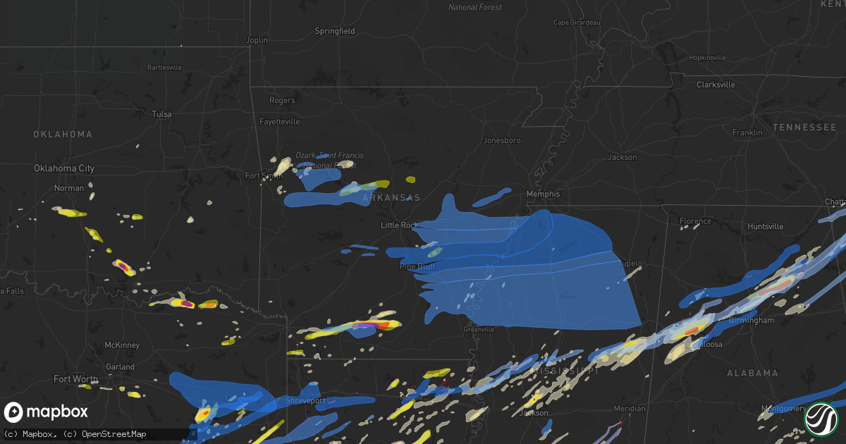
Hail Map in Arkansas on April 12, 2020
Get this storm
April 12 map
$229
one time, instant access
Download today. No call, no setup
Keep the $229
Bought the map and want the full workflow? Apply the entire $229 to a subscription within 7 days. None of it is wasted.
Every map, not just this one
This buys you this map. Subscription and you get every map we run, in the markets you choose from a few cities to whole states to nationwide. Plus real-time alerts the moment a storm fires.
Contact data
Name, contact info, occupancy, even credit band for addresses in the footprint. You go from where it hit to who to call.
Become the source they trust
Unlimited branding weather history reports on demand. You already have the documented answer ready for the property owner, and you are the one who showed up with it.
Property data and RoofTrace estimates
Pull up any address you have got, its value and the exact code rules for that jurisdiction, straight from One Click Code. Then RoofTrace estimates the squares, pitch, and roof value, priced the way you price.
Storm reports in Arkansas
Arkansas
| Date | Description |
|---|---|
| 04/12/20206:54 PM CDT | 60 mph wind gust. |
| 04/12/20206:51 PM CDT | Trees were down along with power outages. A dock was damaged. |
| 04/12/20206:43 PM CDT | Trees knocked down... And blocking highway 21 in ozone. |
| 04/12/20206:39 PM CDT | Mulitple large trees knocked down. |
| 04/12/20206:31 PM CDT | Emergency manager reports trees and powerlines down at intersection of highway 116 and 23. |
| 04/12/20206:31 PM CDT | Em reports a roof blown off of a polutry farm on highway 154 north of danville. |
| 04/12/20206:30 PM CDT | Tree down on power lines on fuller mill road. |
| 04/12/20206:23 PM CDT | Emergency manager reports tree down and power out in the goosecamp area. |
| 04/12/20206:23 PM CDT | Trees down and blocking highway 64... West of clarksville. |
| 04/12/20206:11 PM CDT | One barn heavily damaged. Several large trees down. |
| 04/12/20206:07 PM CDT | A local report indicates 60 MPH wind near 1 S OZARK |
| 04/12/202011:05 AM CDT | Large trees reported down... Large signs down and small metal building destroyed at fire station #3 in el dorado. |
| 04/12/20207:26 AM CDT | At 1226 PM CDT, a severe thunderstorm was located near Gassoway, or near Eudora, moving northeast at 60 mph. HAZARD...60 mph wind gusts and quarter size hail. SOURCE...Radar indicated. IMPACT...Hail damage to vehicles is expected. Expect wind damage to roofs, siding, and trees. This severe thunderstorm will be near... Glen Allan around 1235 PM CDT. Avon around 1245 PM CDT. Hollandale and Estill around 1250 PM CDT. Darlove around 1255 PM CDT. Tribbett around 100 PM CDT.Other locations impacted by this severe thunderstorm include Arcola. |
| 04/12/20206:34 AM CDT | At 1134 AM CDT, a severe thunderstorm was located 7 miles northeast of Lapile, or 10 miles north of Huttig, moving east at 60 mph. HAZARD...60 mph wind gusts and penny size hail. SOURCE...Radar indicated. IMPACT...Expect damage to roofs, siding, and trees. This severe thunderstorm will be near... West Crossett around 1145 AM CDT. North Crossett around 1150 AM CDT. Old Milo around 1155 AM CDT. Hamburg and Fountain Hill around 1200 PM CDT. Snyder around 1210 PM CDT. Montrose around 1215 PM CDT.Other locations impacted by this severe thunderstorm includeBlanchton. |
| 04/12/20204:50 AM CDT | At 950 PM CDT, severe thunderstorms were located along a line extending from Madison to 6 miles southeast of Dundee to Tutwiler, moving northeast at 70 mph. HAZARD...70 mph wind gusts. SOURCE...Radar indicated. IMPACT...Expect considerable tree damage. Damage is likely to mobile homes, roofs, and outbuildings. Locations impacted include... Southaven, Horn Lake, Oxford, Hernando, Senatobia, Batesville, Water Valley, Charleston, George Payne State Park, Holly Springs National Forest, John W Kyle State Park, Marks, Sardis, Coldwater, Como, Walls, Tunica, Coffeeville, Crenshaw and Crowder. |
| 04/12/20204:31 AM CDT | At 931 PM CDT, severe thunderstorms were located along a line extending from near Wheatley to near Marvell to 6 miles south of Sherard, moving northeast at 65 mph. HAZARD...70 mph wind gusts. SOURCE...Radar indicated. IMPACT...Expect considerable tree damage. Damage is likely to mobile homes, roofs, and outbuildings. Locations impacted include... Clarksdale, Marianna, Marvell, Elaine, St Francis National Park, Helena-West Helena, Tutwiler, Marks, Lambert, Jonestown, Friars Point, Tunica, Crenshaw, Crowder, Webb, Sledge, Sumner, Lexa, Moro and Rondo. |
| 04/12/20204:25 AM CDT | At 925 PM CDT, severe thunderstorms were located along a line extending from 7 miles west of Algoa to near New Salem, moving east at 50 mph. HAZARD...60 mph wind gusts. SOURCE...Radar indicated. IMPACT...Expect damage to roofs, siding, and trees. Locations impacted include... Forrest City, Wynne, Harrisburg, Parkin, Madison, Palestine, Village Creek State Park, Weiner, Cherry Valley, Caldwell, Colt, Wheatley, Widener, Hickory Ridge, Waldenburg, Fair Oaks, Vanndale, Greenfield, New Home and Fisher. |
| 04/12/20204:09 AM CDT | At 909 PM CDT, severe thunderstorms were located along a line extending from 8 miles west of Eudora to 7 miles south of Galion, moving east at 75 mph. HAZARD...60 mph wind gusts and quarter size hail. SOURCE...Radar indicated. IMPACT...Hail damage to vehicles is expected. Expect wind damage to roofs, siding, and trees. Severe thunderstorms will be near... Gassoway around 920 PM CDT. Oak Grove and Darnell around 925 PM CDT. Grace around 930 PM CDT. Lake Providence, Transylvania, Panther Burn and Nitta Yuma around 935 PM CDT. Delta City around 940 PM CDT. Fitler and Onward around 945 PM CDT.Other locations impacted by these severe thunderstorms includeMayersville, Pioneer, Kilbourne, Forest, Cary, Oak Ridge and Epps. |
| 04/12/20203:53 AM CDT | At 853 PM CDT, severe thunderstorms were located along a line extending from near Pleasant Plains to Bald Knob to 6 miles south of Pryor to near Des Arc to near Parkers Corner, moving east at 40 mph. HAZARD...60 mph wind gusts and quarter size hail. SOURCE...Radar indicated. IMPACT...Hail damage to vehicles is expected. Expect wind damage to roofs, siding, and trees. Locations impacted include... Newport... Brinkley... Augusta... Des Arc... Clarendon... Hazen... De Valls Bluff... Bald Knob... Diaz... Patterson... Grubbs... Fredonia... Pleasant Plains... Russell... Tupelo... Hunter... Algoa... Alfrey... Allendale... Dobbs Landing...This includes the following highways... Interstate 40 between mile markers 189 and 218. US Highway 67 between mile markers 53 and 85. |
| 04/12/20203:51 AM CDT | At 851 PM CDT, severe thunderstorms were located along a line extending from near Parkers Corner to 7 miles northeast of Langford to 6 miles southwest of Tillar, moving east at 50 mph. HAZARD...70 mph wind gusts. SOURCE...Radar indicated. IMPACT...Expect considerable tree damage. Damage is likely to mobile homes, roofs, and outbuildings. Locations impacted include... Clarksdale, Marianna, Marvell, Elaine, Helena-West Helena, St Francis National Park, Friars Point, Lexa, Moro, Rondo, Aubrey, Haynes, Garret Grove, Watkins Corner, Kings, Sherard, New Salem, Crumrod, Lake View and Coahoma. |
| 04/12/20203:46 AM CDT | At 846 PM CDT, severe thunderstorms were located along a line extending from 6 miles northeast of Mitchellville to 9 miles north of Snyder, moving east at 50 mph. HAZARD...70 mph wind gusts and quarter size hail. SOURCE...Radar indicated. IMPACT...Hail damage to vehicles is expected. Expect considerable tree damage. Wind damage is also likely to mobile homes, roofs, and outbuildings. Severe thunderstorms will be near... Gunnison around 920 PM CDT. Deeson around 930 PM CDT. Shelby around 935 PM CDT.Other locations impacted by these severe thunderstorms includeAlligator, Winstonville, Beulah, Duncan, Pace and Merigold. |
| 04/12/20203:44 AM CDT | At 844 PM CDT, severe thunderstorms were located along a line extending from near Tillar to Snyder, moving east at 50 mph. HAZARD...60 mph wind gusts and quarter size hail. SOURCE...Radar indicated. IMPACT...Hail damage to vehicles is expected. Expect wind damage to roofs, siding, and trees. Severe thunderstorms will be near... Mcmillan Corner around 905 PM CDT. Lake Village and Chicot Junction around 910 PM CDT. Avon and Wayside around 925 PM CDT. Estill around 935 PM CDT. Tribbett and Darlove around 940 PM CDT.Other locations impacted by these severe thunderstorms includeArcola. |
| 04/12/20203:19 AM CDT | At 819 PM CDT, severe thunderstorms were located along a line extending from near Old Lexington to 6 miles southwest of Heber Springs to near Gravel Hill to Cabot to near Ironton, moving east at 45 mph. HAZARD...60 mph wind gusts and quarter size hail. SOURCE...Radar indicated. IMPACT...Hail damage to vehicles is expected. Expect wind damage to roofs, siding, and trees. Locations impacted include... Little Rock... North Little Rock... Cabot... Searcy... Heber Springs... Lonoke... Mountain View... Des Arc... Beebe... Ward... Bald Knob... Carlisle... Austin in Lonoke County... Judsonia... Kensett... Greers Ferry... Higginson... Pangburn... Cushman... Pleasant Plains...This includes the following highways... Interstate 40 between mile markers 161 and 191. Interstate 440 between mile markers 5 and 8. US Highway 67 between mile markers 23 and 59. |
| 04/12/20203:14 AM CDT | At 814 PM CDT, a severe thunderstorm was located near Bastrop, moving northeast at 70 mph. HAZARD...Ping pong ball size hail and 60 mph wind gusts. SOURCE...Radar indicated. IMPACT...People and animals outdoors will be injured. Expect hail damage to roofs, siding, windows, and vehicles. Expect wind damage to roofs, siding, and trees. This severe thunderstorm will be near... Beekman around 820 PM CDT. Galion around 825 PM CDT. Jones around 835 PM CDT.Other locations impacted by this severe thunderstorm includeCollinston, Mer Rouge and Bonita. |
| 04/12/20203:08 AM CDT | At 808 PM CDT, severe thunderstorms were located along a line extending from near Hermitage to Strong, moving east at 55 mph. HAZARD...60 mph wind gusts and quarter size hail. SOURCE...Radar indicated. IMPACT...Hail damage to vehicles is expected. Expect wind damage to roofs, siding, and trees. Severe thunderstorms will be near... Fountain Hill and Old Milo around 825 PM CDT. Crossett, West Crossett and North Crossett around 830 PM CDT. Snyder around 840 PM CDT. Berlin around 845 PM CDT. Montrose around 850 PM CDT. Wilmot and Parkdale around 855 PM CDT.Other locations impacted by these severe thunderstorms includeBlanchton. |
| 04/12/20202:56 AM CDT | At 756 PM CDT, a severe thunderstorm was located over Harrell, or near Hampton, moving east at 60 mph. HAZARD...70 mph wind gusts and ping pong ball size hail. SOURCE...Radar indicated. IMPACT...People and animals outdoors will be injured. Expect hail damage to roofs, siding, windows, and vehicles. Expect considerable tree damage. Wind damage is also likely to mobile homes, roofs, and outbuildings. Locations impacted include... Monticello... Warren... Hampton... Hermitage... Wilmar... Harrell... Tillar... Hampton Municipal Airport... Ladelle... Green Hill... Lanark... Prairie Grove... Banks... Jerome... Baxter... Carmel... Farmville... Enon... Selma... Gravelridge... |
| 04/12/20202:49 AM CDT | At 748 PM CDT, a severe thunderstorm was located near Emerson, or 11 miles east of Springhill, moving east at 35 mph. HAZARD...60 mph wind gusts and quarter size hail. SOURCE...Radar indicated. IMPACT...Hail damage to vehicles is expected. Expect wind damage to roofs, siding, and trees. Locations impacted include... Springhill, Junction City, Haynesville, Cullen, Taylor, Emerson, Shongaloo, Bussey, Atlanta, Wesson, Cooley, Welcome, Spearsville, Lillie, Hew Hope, Newell, Walkerville, Summerfield, Noxobe and Three Creeks. |
| 04/12/20202:45 AM CDT | At 744 PM CDT, severe thunderstorms were located along a line extending from 8 miles northeast of Lonsdale to near Traskwood to Jenkins Ferry State Park to near Carthage to near Sparkman, moving east at 80 mph. HAZARD...60 mph wind gusts and quarter size hail. SOURCE...Radar indicated. IMPACT...Hail damage to vehicles is expected. Expect wind damage to roofs, siding, and trees. Locations impacted include... Little Rock... Pine Bluff... Benton... Bryant... Sheridan... Star City... Rison... White Hall... Shannon Hills... England... Wrightsville... Redfield... Altheimer... Humphrey... Leola... Tull... Kingsland... Carthage... Prattsville... Humnoke...This includes the following highways... Interstate 30 between mile markers 117 and 127. Interstate 530 between mile markers 5 and 46. |
| 04/12/20202:33 AM CDT | At 732 PM CDT, severe thunderstorms were located along a line extending from near Dabney to near Cleveland to near Menifee to Little Italy to 7 miles east of Hot Springs Village, moving east at 45 mph. HAZARD...60 mph wind gusts and quarter size hail. SOURCE...Radar indicated. IMPACT...Hail damage to vehicles is expected. Expect wind damage to roofs, siding, and trees. Locations impacted include... Little Rock... North Little Rock... Conway... Sherwood... Jacksonville... Cabot... West Little Rock... Maumelle... Bryant... Hot Springs Village... Downtown Little Rock... Heber Springs... Clinton... Fairfield Bay... North Little Rock Airport... Little Rock AFB... Southwest Little Rock... Greenbrier... Ward... Vilonia...This includes the following highways... Interstate 30 between mile markers 127 and 142. Interstate 40 between mile markers 115 and 161. Interstate 430 between mile markers 1 and 12. Interstate 530 between mile markers 1 and 5. Interstate 630 between mile markers 1 and 7. Interstate 440 between mile markers 1 and 14. US Highway 67 between mile markers 1 and 23. |
| 04/12/20202:22 AM CDT | At 721 AM CDT, a severe thunderstorm was located near Kelso, or near Rohwer, moving northeast at 45 mph. HAZARD...Quarter size hail. SOURCE...Radar indicated. IMPACT...Damage to vehicles is expected. This severe thunderstorm will be near... Rosedale around 730 AM CDT.Other locations impacted by this severe thunderstorm includeAlligator, Beulah, Duncan and Pace. |
| 04/12/20202:18 AM CDT | At 718 PM CDT, a severe thunderstorm was located near Bradley, or 18 miles west of Springhill, moving east at 50 mph. HAZARD...60 mph wind gusts and quarter size hail. SOURCE...Radar indicated. IMPACT...Hail damage to vehicles is expected. Expect wind damage to roofs, siding, and trees. Locations impacted include... Springhill, Cullen, Bradley, Taylor, Shongaloo, Bussey, Canfield, Macedonia, Welcome, Pleasant Valley, Gin City, Walkerville, State Line, Canale, Horsehead, Fort Lynn and Kiblah. |
| 04/12/20202:18 AM CDT | At 717 PM CDT, a severe thunderstorm was located over Stephens, or 10 miles northeast of McNeil, moving east at 50 mph. HAZARD...60 mph wind gusts and quarter size hail. SOURCE...Radar indicated. IMPACT...Hail damage to vehicles is expected. Expect wind damage to roofs, siding, and trees. Locations impacted include... Camden... Hampton... Stephens... Harrell... Louann... Cullendale... Hampton Municipal Airport... Tinsman... Artesian... Delhi... Kirkland... Millers Bluff... Frenchport... Elliot... Cross Roads in Ouachita County... Fairview in Ouachita County... Locust Bayou... Troy... Standard Umpstead... Woodberry... |
| 04/12/20202:10 AM CDT | At 710 PM CDT, severe thunderstorms were located along a line extending from near Lake Ouachita State Park to near Lofton to near Amity to 8 miles west of Halfway to near Crater Of Diamonds State Park, moving east at 70 mph. HAZARD...60 mph wind gusts and quarter size hail. SOURCE...Radar indicated. IMPACT...Hail damage to vehicles is expected. Expect wind damage to roofs, siding, and trees. Locations impacted include... Hot Springs... Benton... Hot Springs Village... Arkadelphia... Malvern... Haskell... Gurdon... Mountain Pine... Rockport... Caddo Valley... Traskwood... Tull... Sparkman... Prattsville... Poyen... Perla... Okolona... Lonsdale... Gum Springs in Clark County... Jenkins Ferry State Park...This includes Interstate 30 between mile markers 55 and 117. |
| 04/12/20202:10 AM CDT | At 710 PM CDT, a severe thunderstorm was located near Stephens, or near McNeil, moving east at 50 mph. HAZARD...60 mph wind gusts and quarter size hail. SOURCE...Radar indicated. IMPACT...Hail damage to vehicles is expected. Expect wind damage to roofs, siding, and trees. Locations impacted include... El Dorado, Magnolia, Smackover, Waldo, Norphlet, McNeil, Calion, Rosston, Louann, Willisville, Mount Holly, Smithland, Village, Lisbon, Urbana, Lawson, Macedonia, Bussey, Moro Bay State Park and Calhoun. |
| 04/12/20201:56 AM CDT | At 655 PM CDT, severe thunderstorms were located along a line extending from near Rosetta to near Dover to near Dardanelle to near Ola to 12 miles northwest of Lake Ouachita State Park, moving east at 40 mph. HAZARD...60 mph wind gusts and quarter size hail. SOURCE...Radar indicated. IMPACT...Hail damage to vehicles is expected. Expect wind damage to roofs, siding, and trees. Locations impacted include... Conway... Russellville... Hot Springs Village... Morrilton... Perryville... Dardanelle... Atkins... Pottsville... Dover... Ola... London... Oppelo... Hector... Menifee... Perry... Adona... Houston... Bethlehem... Hill Creek... Jessieville...This includes Interstate 40 between mile markers 77 and 122. |
| 04/12/20201:38 AM CDT | At 637 PM CDT, a severe thunderstorm was located over Mimosa, or 7 miles west of Mount Ida, moving east at 35 mph. HAZARD...60 mph wind gusts and quarter size hail. SOURCE...Radar indicated. IMPACT...Hail damage to vehicles is expected. Expect wind damage to roofs, siding, and trees. Locations impacted include... Mount Ida... Glenwood... Mountain Pine... Amity... Norman... Oden... Opal... Mimosa... Little Missouri Falls Recreatio... Meyers... Lake Ouachita State Park... Lofton... Bard Springs Recreation Area... Mauldin... Albert Pike Recreation Area... Avant... Bismarck... Black Springs... Big Fork... Bonnerdale... |
| 04/12/20201:06 AM CDT | At 606 PM CDT, severe thunderstorms were located along a line extending from near Fern to Ozark to near Paris to 6 miles northeast of Cardiff to 10 miles southeast of Waldron, moving east at 40 mph. HAZARD...60 mph wind gusts and quarter size hail. SOURCE...Radar indicated. IMPACT...Hail damage to vehicles is expected. Expect wind damage to roofs, siding, and trees. Locations impacted include... Russellville... Clarksville... Paris... Danville... Dardanelle... Atkins... Pottsville... Lamar... Dover... Ola... London... Magazine... Knoxville... Subiaco... Hartman... Scranton... Blue Mountain... Devils Knob... Mosley... Holman...This includes Interstate 40 between mile markers 45 and 91. |
| 04/12/202012:44 AM CDT | At 544 PM CDT, a severe thunderstorm was located near Washburn, or 7 miles west of Booneville, moving east at 45 mph. HAZARD...60 mph wind gusts and quarter size hail. SOURCE...Radar indicated. IMPACT...Hail damage to vehicles is expected. Expect wind damage to roofs, siding, and trees. Locations impacted include... Booneville... Magazine... Blue Mountain... Stonehouse Recreation Area... Mount Magazine... Belleville... Havana... Barber... Macedonia in Yell County... Waveland... Lucas... Chismville... Sugar Grove... Carolan... Corley... Grayson... Glendale in Logan County... Ione... |
| 04/11/202010:20 PM CDT | Trees blocking highway 149 south of earle. |
| 04/11/20209:40 PM CDT | Tree down along ark hwy 261 west of caldwell... Arkansas. |
| 04/11/20209:40 PM CDT | Powerpoles and trees down across helena-west helena. Multiple buildings downtown damaged or destroyed including centennial baptist church that sustained significant dam |
| 04/11/20209:22 PM CDT | Power lines damaged. |
| 04/11/20209:15 PM CDT | Trees and power lines down. |
| 04/11/20209:10 PM CDT | Damage occurred to a mobile home. Roof damage occurred to a home and a small shed was blown away. |
| 04/11/20209:00 PM CDT | Trees damaged. |
| 04/11/20208:58 PM CDT | A local report indicates 60 MPH wind near STUTTGART MUNICIPAL AIR |
| 04/11/20208:57 PM CDT | Wind gust measured from a trained spotter weather station. |
| 04/11/20208:55 PM CDT | Several trees blown down. |
| 04/11/20208:55 PM CDT | A power line was blown down on highway 33 south of de valls bluff blocking all lanes. |
| 04/11/20208:46 PM CDT | Trees and power poles damaged. |
| 04/11/20208:45 PM CDT | Roofs were peeled back or blown off of several outbuildings. Several trees were snapped. |
| 04/11/20208:44 PM CDT | Quarter sized hail in humphrey. |
| 04/11/20208:42 PM CDT | Several trees were blown down as well as a few powerlines. |
| 04/11/20208:35 PM CDT | Trees and power poles. |
| 04/11/20208:34 PM CDT | Multiple trees and powerlines knocked down in monticello. |
| 04/11/20208:33 PM CDT | Multiple trees and power lines down in star city. |
| 04/11/20208:30 PM CDT | Trees and power lines down. |
| 04/11/20208:25 PM CDT | Numerous trees blown down as well as powerlines. Some damage to roofs as well as small sheds occurred. |
| 04/11/20208:24 PM CDT | Public reports multiple trees down in rye. |
| 04/11/20208:19 PM CDT | Storm spotter reports trees and power lines down in whitehall. |
| 04/11/20208:19 PM CDT | A local report indicates 60 MPH wind near REDFIELD |
| 04/11/20208:16 PM CDT | Public reports quarter size hail in rose bud. |
| 04/11/20208:16 PM CDT | Fire chief in watson chapel estimates 70 mph wind gust. |
| 04/11/20208:15 PM CDT | *** 1 fatal *** numerous trees and powerlines down in the area. One fatality occurred after a tree fell on a residence. |
| 04/11/20208:12 PM CDT | Multiple large trees and powerlines down... Blocking portions of highway 270. |
| 04/11/20208:11 PM CDT | Trees and powerlines were reported down on east end rd. In east end. Nws storm survey confirmed straight-line winds. |
| 04/11/20208:10 PM CDT | Widespread damage occurred across the county with numerous trees and powerlines down. Some roads in the county were blocked due to the extent of the downed trees. |
| 04/11/20208:00 PM CDT | Trees down and blocking kanis road in west little rock. |
| 04/11/20208:00 PM CDT | Several trees were blown down with some damage noted to small outbuildings. |
| 04/11/20207:57 PM CDT | Social media report of quarter size hail in harrell. |
| 04/11/20207:56 PM CDT | A local report indicates 70 MPH wind near LEOLA |
| 04/11/20207:55 PM CDT | Downed trees caused portions of highway 274 to be blocked. |
| 04/11/20207:54 PM CDT | Trees knocked down in tull. |
| 04/11/20207:53 PM CDT | Several trees were blown down. A house sustained roof damage... And a camper was flipped over. |
| 04/11/20207:52 PM CDT | Social media report of ping pong ball sized hail. |
| 04/11/20207:49 PM CDT | Multiple large trees knocked down. |
| 04/11/20207:45 PM CDT | Portions of highway 65 were blocked by downed powerlines. |
| 04/11/20207:41 PM CDT | Quarter size hail reported by storm spotters. |
| 04/11/20207:40 PM CDT | Smackover police department reports numerous trees and power lines down across the city. |
| 04/11/20207:40 PM CDT | Numerous trees and power lines down across the city. |
| 04/11/20207:36 PM CDT | Multiple trees... Powerlines... And fences down in downtown malvern. |
| 04/11/20207:33 PM CDT | A tree was down on highway 53 north of walker creek. |
| 04/11/20207:31 PM CDT | Multiple trees down in plummerville. |
| 04/11/20207:31 PM CDT | A local report indicates 1.25 inch wind near LOUANN |
| 04/11/20207:31 PM CDT | Public reports quarter size hail. |
| 04/11/20207:27 PM CDT | A few trees were blown down in the area. |
| 04/11/20207:22 PM CDT | Public reports multiple trees down... With some trees on cars in hot springs. |
| 04/11/20207:20 PM CDT | Fire department reports trees and powerlines down on highway 95 north of morrilton... Blocking the road. |
| 04/11/20207:13 PM CDT | The cooperative observer from antoine 1 sw reported 8-10 trees blown down in town. Also... Small hail fell. Event time is based on radar. |
| 04/11/20207:07 PM CDT | A local report indicates 1.00 inch wind near 12 W BRADLEY |
| 04/11/20207:06 PM CDT | Public weather station measured a 68 mph wind gust. |
| 04/11/20207:02 PM CDT | A tree was down on a mobile home near the oakhaven community. |
| 04/11/20207:02 PM CDT | Multiple large trees down in pearcy. Spotter estimates 60 mph wind gusts. |
| 04/11/20207:00 PM CDT | Large hail and strong winds. |
All States Impacted by Hail Map on April 12, 2020
Cities Impacted by Hail Map on April 12, 2020
- Rayville, LA
- Epps, LA
- Pioneer, LA
- Delhi, LA
- Monroe, LA
- Burkeville, TX
- Boaz, AL
- Pinola, MS
- Magee, MS
- Mendenhall, MS
- Raleigh, MS
- McRae Helena, GA
- Milan, GA
- Covington, LA
- Springfield, LA
- Robert, LA
- Ponchatoula, LA
- Folsom, LA
- Loranger, LA
- Hammond, LA
- Deridder, LA
- Rocky Ford, GA
- Sylvania, GA
- Kilgore, TX
- Longview, TX
- Gordo, AL
- Knoxville, AL
- Aliceville, AL
- Eutaw, AL
- Ralph, AL
- Mountainburg, AR
- Rudy, AR
- Alma, AR
- Roxton, TX
- Hardeeville, SC
- Henderson, TX
- Colquitt, GA
- Gonzales, LA
- Baton Rouge, LA
- Prairieville, LA
- Douglass, TX
- Allen, OK
- Noxapater, MS
- Louisville, MS
- Sikes, LA
- Cameron, TX
- Merryville, LA
- Lumberton, MS
- Purvis, MS
- Saint Martinville, LA
- New Iberia, LA
- Jeanerette, LA
- Loreauville, LA
- Hampton, AR
- Kosciusko, MS
- Pickens, MS
- Lexington, MS
- Durant, MS
- Columbia, LA
- Grayson, LA
- Pelsor, AR
- Dover, AR
- Wanette, OK
- Macomb, OK
- Berry, AL
- Echola, AL
- Elrod, AL
- Northport, AL
- El Dorado, AR
- West Monroe, LA
- Eros, LA
- Chatham, LA
- Calipatria, CA
- Stuttgart, AR
- Troy, AL
- Gallant, AL
- Altoona, AL
- Attalla, AL
- Davis, OK
- Wynnewood, OK
- Fort Smith, AR
- Watson, AR
- Monticello, AR
- Statesboro, GA
- Winnfield, LA
- Peterman, AL
- Coushatta, LA
- Pineland, SC
- Frankston, TX
- Brantley, AL
- Louann, AR
- Camden, AR
- Trion, GA
- Summerville, GA
- Palestine, TX
- Crockett, TX
- Grapeland, TX
- Walker, LA
- Dacula, GA
- Braselton, GA
- Auburn, GA
- Buford, GA
- Lawrenceville, GA
- Flowery Branch, GA
- Hoschton, GA
- McLain, MS
- Perkinston, MS
- Bogalusa, LA
- Carrollton, AL
- Buhl, AL
- Fayette, AL
- Reform, AL
- Coker, AL
- Kennedy, AL
- Shelbyville, TX
- Brandon, MS
- Ridgeland, MS
- Madison, MS
- Jackson, MS
- Maysville, OK
- Lindsay, OK
- Satartia, MS
- Center, TX
- Newellton, LA
- Tallulah, LA
- Saline, LA
- Jonesboro, LA
- Goldonna, LA
- Clayton, AL
- Eufaula, AL
- Shorterville, AL
- Abbeville, AL
- Clopton, AL
- Timpson, TX
- Cushing, TX
- Rusk, TX
- Alto, TX
- Smithdale, MS
- Liberty, MS
- Harrisville, MS
- Braxton, MS
- Sorrento, LA
- Kennard, TX
- Wayne, OK
- Purcell, OK
- Harrisonburg, LA
- Calhoun, LA
- Natchitoches, LA
- Lewisville, AR
- Desoto, TX
- Lancaster, TX
- Dallas, TX
- Duncanville, TX
- Cedar Hill, TX
- Flint, TX
- Tyler, TX
- Whitehouse, TX
- Thomasville, AL
- Clayton, LA
- Detroit, TX
- Bagwell, TX
- Steele, AL
- Remlap, AL
- Oneonta, AL
- Flora, MS
- Scurry, TX
- Kaufman, TX
- Colfax, LA
- Ratcliff, AR
- Ozark, AR
- Downsville, LA
- Farmerville, LA
- Elkhart, TX
- Tuscumbia, AL
- Talco, TX
- Seagoville, TX
- Ferris, TX
- Arnaudville, LA
- Sallis, MS
- Wills Point, TX
- Terrell, TX
- Franklinton, LA
- McNeil, AR
- Buckner, AR
- Waldo, AR
- Banks, AR
- Stamps, AR
- Stephens, AR
- Blossom, TX
- Pine Valley, CA
- Campo, CA
- Boulevard, CA
- Calvin, OK
- Bay Springs, MS
- Heidelberg, MS
- Laurel, MS
- Pinson, AL
- Morris, AL
- Cleveland, AL
- Mount Olive, AL
- Trafford, AL
- Locust Fork, AL
- Gardendale, AL
- Graysville, AL
- Poplarville, MS
- Ohatchee, AL
- Paris, TX
- Sumner, TX
- Nacogdoches, TX
- Tenaha, TX
- Mount Enterprise, TX
- Gary, TX
- Carthage, TX
- Garrison, TX
- Laughlin, NV
- Searchlight, NV
- Scooba, MS
- Hartshorne, OK
- Collins, MS
- Texarkana, AR
- Fouke, AR
- Sulphur, OK
- Canton, MS
- Dardanelle, AR
- Pottsville, AR
- Russellville, AR
- Atkins, AR
- Mount Pleasant, TX
- Tifton, GA
- Enigma, GA
- Buckholts, TX
- Wells, TX
- Clarksville, TX
- Cecil, AR
- Highland Home, AL
- Goshen, AL
- Luverne, AL
- Grady, AL
- Rutledge, AL
- Donaldsonville, LA
- Belle Rose, LA
- Plattenville, LA
- Fort Scott, KS
- Uniontown, KS
- Taylor, AR
- Mer Rouge, LA
- Bastrop, LA
- Kenefic, OK
- Durant, OK
- Bassfield, MS
- Prentiss, MS
- Estill, SC
- Millen, GA
- Garfield, GA
- Tishomingo, OK
- Milburn, OK
- Ashdown, AR
- McGehee, AR
- Tillar, AR
- Troup, TX
- Metter, GA
- Kaplan, LA
- Lamar, AR
- White Oak, TX
- Gladewater, TX
- Trout, LA
- Abbeville, GA
- Eastman, GA
- McCool, MS
- Philadelphia, MS
- Preston, MS
- Brooksville, MS
- Macon, MS
- Shuqualak, MS
- Claxton, GA
- Woodville, MS
- Samson, AL
- Kinston, AL
- Olla, LA
- Haughton, LA
- Benton, LA
- Collins, GA
- Lyons, GA
- Mulberry, AR
- Dyer, AR
- Booneville, AR
- Greenwood, AR
- Robeline, LA
- Holden, LA
- Livingston, LA
- French Settlement, LA
- De Kalb, TX
- Avery, TX
- Brookston, TX
- Honey Grove, TX
- Arthur City, TX
- Mapleton, KS
- Altheimer, AR
- Wabbaseka, AR
- Silver City, MS
- Alex, OK
- Blanchard, OK
- Jacksonville, TX
- Leakesville, MS
- Guild, TN
- Trenton, GA
- Ethelsville, AL
- Edwards, MS
- Starkville, MS
- Lena, MS
- Camden, MS
- Bolton, MS
- Morton, MS
- Oakman, AL
- Raymond, MS
- Columbus, MS
- Clinton, MS
- Carthage, MS
- Crawford, MS
- Tuscaloosa, AL
- Arlington, TX
- Kennedale, TX
- Fort Worth, TX
- Scott, LA
- Lafayette, LA
- Carencro, LA
- Duson, LA
- Breaux Bridge, LA
- Rayne, LA
- Morse, LA
- Gueydan, LA
- Crowley, LA
- Magnolia, MS
- Pollock, LA
- Dry Prong, LA
- Georgetown, LA
- Tullos, LA
- Millport, AL
- Lake Providence, LA
- Opp, AL
- Dickinson, AL
- Grove Hill, AL
- Vicksburg, MS
- Garland, KS
- Farlington, KS
- Arcadia, KS
- Red Oak, OK
- Carnesville, GA
- Boulder City, NV
- Muscle Shoals, AL
- Haynesville, LA
- Junction City, AR
- Quincy, FL
- Ramer, AL
- Port Allen, LA
- Apison, TN
- McDonald, TN
- Cleveland, TN
- Tupelo, OK
- Ridgeland, SC
- Carville, LA
- Geismar, LA
- Maurepas, LA
- Saint Gabriel, LA
- Albany, LA
- Denham Springs, LA
- Saint Amant, LA
- White Castle, LA
- Independence, LA
- Tickfaw, LA
- Carson, MS
- Seminary, MS
- Taylorsville, MS
- Bullard, TX
- Lowndesboro, AL
- Glenwood, AL
- Powderly, TX
- Silver Creek, MS
- Campti, LA
- Florala, AL
- Rush Springs, OK
- Fosters, AL
- Atoka, OK
- Bay Saint Louis, MS
- Stennis Space Center, MS
- Cataula, GA
- Twin City, GA
- Springville, AL
- Kimberly, AL
- Warrior, AL
- Birmingham, AL
- Portal, GA
- Mansfield, LA
- Pelican, LA
- Chauncey, GA
- Amite, LA
- Greensburg, LA
- Pine Grove, LA
- Humphrey, AR
- Bennington, OK
- Bokchito, OK
- Converse, LA
- Letohatchee, AL
- Hayneville, AL
- Benton, MS
- Tishomingo, MS
- Dennis, MS
- Ada, OK
- Grand Chenier, LA
- Maurice, LA
- Bradley, SC
- Rainbow City, AL
- Mayersville, MS
- Rolling Fork, MS
- Calion, AR
- Darrow, LA
- Townley, AL
- Marshallville, GA
- Booneville, MS
- Nauvoo, AL
- Shelby, MS
- Calera, OK
- Hendrix, OK
- Greenville, AL
- Mccomb, MS
- Tylertown, MS
- Summit, MS
- Jayess, MS
- Ruth, MS
- Oakwood, TX
- West, MS
- Vaiden, MS
- Tennille, GA
- Garnett, SC
- Clinton, LA
- Norwood, LA
- Hayden, AL
- Marthaville, LA
- Vaughan, MS
- Choudrant, LA
- Springer, OK
- Springfield, AR
- Hattieville, AR
- Solgohachia, AR
- Morrilton, AR
- Caddo, OK
- Lucedale, MS
- Wiggins, MS
- Doddridge, AR
- Sulphur Springs, TX
- Early Branch, SC
- Varnville, SC
- Fitzpatrick, AL
- Hattiesburg, MS
- Emerson, AR
- Hope Hull, AL
- Prattville, AL
- Montgomery, AL
- Bullhead City, AZ
- Rossville, GA
- Ringgold, GA
- Fort Oglethorpe, GA
- Singer, LA
- Sondheimer, LA
- La Place, LA
- Bradley, AR
- Harrell, AR
- Jersey, AR
- Garland City, AR
- Rosston, AR
- Thornton, AR
- Ozark, AL
- Skipperville, AL
- Rochelle, GA
- McCune, KS
- Houston, MS
- McIntyre, GA
- Toomsboro, GA
- Ivanhoe, TX
- Ravenna, TX
- Madill, OK
- Fort Valley, GA
- Chattanooga, TN
- Chickasha, OK
- Tillman, SC
- Altus, AR
- Clarksville, AR
- Adger, AL
- Albertville, AL
- Mulga, AL
- Quinton, AL
- Horton, AL
- Dawson, AL
- Crossville, AL
- Brookside, AL
- Bessemer, AL
- Adamsville, AL
- Blountsville, AL
- Geraldine, AL
- Dora, AL
- Ashville, AL
- Lincoln, AL
- Anniston, AL
- Brawley, CA
- Pembroke, GA
- Buckatunna, MS
- Millry, AL
- State Line, MS
- Yazoo City, MS
- Mound Valley, KS
- Parsons, KS
- Wilburton, OK
- Cherokee, AL
- Pollok, TX
- Ethel, MS
- Bentonia, MS
- Perry, GA
- Picayune, MS
- Lavaca, AR
- Carriere, MS
- Humnoke, AR
- Gadsden, AL
- Cooper, TX
- Marietta, TX
- Douglassville, TX
- Naples, TX
- Lapine, AL
- Honoraville, AL
- Sardis, MS
- Jackson, AL
- Sunflower, AL
- Leroy, AL
- McIntosh, AL
- Deer Park, AL
- Gainestown, AL
- Wagarville, AL
- Pearl River, LA
- Altamont, KS
- Chatom, AL
- Beaumont, MS
- Gaylesville, AL
- Odenville, AL
- Goodman, MS
- Gilbert, LA
- Winnsboro, LA
- Mathews, AL
- Tougaloo, MS
- Enterprise, LA
- Fort Gaines, GA
- Elba, AL
- Valley Park, MS
- Register, GA
- Annona, TX
- Hampton, SC
- Coffeyville, KS
- Jesup, GA
- McKenzie, AL
- Red Level, AL
- Springhill, LA
- Soperton, GA
- Swainsboro, GA
- Bristow, OK
- Oak Grove, LA
- Natchez, LA
- Cloutierville, LA
- Montgomery, LA
- Hornbeck, LA
- Plain Dealing, LA
- Oak Ridge, LA
- Fort Necessity, LA
- Lena, LA
- Atlanta, LA
- Beatrice, AL
- Vredenburgh, AL
- Pocola, OK
- Hartman, AR
- Coal Hill, AR
- Arp, TX
- Winona, TX
- Sumrall, MS
- Soso, MS
- Mount Olive, MS
- Dalton, GA
- Oak Vale, MS
- Baker, LA
- Greenwell Springs, LA
- Zachary, LA
- Pride, LA
- Petersburg, TX
- Slaughter, LA
- Cement, OK
- Anadarko, OK
- Mill Creek, OK
- Homer, GA
- Transylvania, LA
- Cary, MS
- Fletcher, OK
- Elgin, OK
- Duncan, MS
- Snow Lake, AR
- Mangham, LA
- Baskin, LA
- Caney, OK
- Mcloud, OK
- Tecumseh, OK
- Chatsworth, GA
- Cookville, TX
- Crandall, TX
- Charleston, AR
- Nettleton, MS
- Okolona, MS
- Shannon, MS
- Plantersville, MS
- Fulton, MS
- England, AR
- Westmorland, CA
- Minden, LA
- Ruleville, MS
- Tucker, AR
- Carbon Hill, AL
- Eldridge, AL
- Bankston, AL
- Seabrook, SC
- Springfield, GA
- Kiln, MS
- Slidell, LA
- Monticello, MS
- Richton, MS
- Telephone, TX
- La Fayette, GA
- Neely, MS
- Brooklyn, MS
- Sicily Island, LA
- Eastaboga, AL
- Pell City, AL
- Riverside, AL
- Ragland, AL
- Grand Prairie, TX
- Monroeville, AL
- Franklin, AL
- Deport, TX
- Pattonville, TX
- Paoli, OK
- Fort Payne, AL
- Collinsville, AL
- Price, TX
- Delaware, AR
- Knoxville, AR
- London, AR
- Magazine, AR
- Paris, AR
- Scranton, AR
- New Blaine, AR
- Subiaco, AR
- Danville, AR
- Casa, AR
- Waldron, AR
- Houston, AR
- Blue Mountain, AR
- Belleville, AR
- Perry, AR
- Perryville, AR
- Havana, AR
- Ola, AR
- Plumerville, AR
- Adona, AR
- Magnolia, AR
- Smackover, AR
- Mount Holly, AR
- Hot Springs National Park, AR
- Malvern, AR
- Traskwood, AR
- Ozone, AR
- El Paso, AR
- Vilonia, AR
- Potts Camp, MS
- Grady, AR
- Coahoma, MS
- Thaxton, MS
- Sledge, MS
- Marks, MS
- Ethel, AR
- Batesville, MS
- Pine Bluff, AR
- Holly Springs, MS
- Nesbit, MS
- Senatobia, MS
- Etta, MS
- Almyra, AR
- Myrtle, MS
- Lyon, MS
- Ashland, MS
- Saint Charles, AR
- Clarksdale, MS
- Waterford, MS
- Holly Grove, AR
- Olive Branch, MS
- Hickory Flat, MS
- Courtland, MS
- Mellwood, AR
- Lambert, MS
- Gillett, AR
- University, MS
- Abbeville, MS
- Blue Mountain, MS
- Crenshaw, MS
- Taylor, MS
- Coldwater, MS
- Hernando, MS
- Como, MS
- Red Banks, MS
- Oxford, MS
- New Albany, MS
- Byhalia, MS
- Elaine, AR
- De Witt, AR
- Belden, MS
- Star City, AR
- Tichnor, AR
- Gould, AR
- Crumrod, AR
- Enid, MS
- Alligator, MS
- Ecru, MS
- Yorktown, AR
- Randolph, MS
- Pope, MS
- Blue Springs, MS
- Water Valley, MS
- Vance, MS
- Oakland, MS
- Paris, MS
- Pontotoc, MS
- Marvell, AR
- Clarendon, AR
- Aubrey, AR
- Ulm, AR
- Scott, AR
- Casscoe, AR
- Dundee, MS
- Helena, AR
- Lonoke, AR
- Marianna, AR
- De Valls Bluff, AR
- West Helena, AR
- Hazen, AR
- Tunica, MS
- Carlisle, AR
- Roe, AR
- Poplar Grove, AR
- Lexa, AR
- Brinkley, AR
- Des Arc, AR
- Wheatley, AR
- Griffithville, AR
- Searcy, AR
- Biscoe, AR
- Robinsonville, MS
- Moro, AR
- Brickeys, AR
- Augusta, AR
- Itta Bena, MS
- Calhoun City, MS
- Cascilla, MS
- Cedarbluff, MS
- Sunflower, MS
- Glendora, MS
- Tutwiler, MS
- Maben, MS
- Mound Bayou, MS
- Merigold, MS
- Tupelo, MS
- Vardaman, MS
- Coila, MS
- Mathiston, MS
- Houlka, MS
- Bellefontaine, MS
- Duck Hill, MS
- Philipp, MS
- Mississippi State, MS
- Pickens, AR
- Banner, MS
- Winona, MS
- Moorhead, MS
- Stewart, MS
- Bruce, MS
- Drew, MS
- Rohwer, AR
- Shaw, MS
- Sidon, MS
- Pheba, MS
- Holcomb, MS
- Arkansas City, AR
- Parchman, MS
- Greenville, MS
- Benoit, MS
- Dumas, AR
- Greenwood, MS
- Grenada, MS
- Eupora, MS
- Scobey, MS
- Tillatoba, MS
- Sumner, MS
- Leland, MS
- Gore Springs, MS
- Doddsville, MS
- Pittsboro, MS
- McCarley, MS
- Walthall, MS
- Winchester, AR
- Ackerman, MS
- Weir, MS
- Boyle, MS
- Big Creek, MS
- Beulah, MS
- Derma, MS
- North Carrollton, MS
- Sturgis, MS
- Woodland, MS
- Carrollton, MS
- Gunnison, MS
- Cleveland, MS
- Schlater, MS
- Aberdeen, MS
- Kilmichael, MS
- Wilmar, AR
- Rosedale, MS
- Prairie, MS
- Dermott, AR
- Minter City, MS
- Indianola, MS
- West Point, MS
- Coffeeville, MS
- Charleston, MS
- Mantee, MS
- Sherrill, AR
- Sheridan, AR
- Southaven, MS
- Redfield, AR
- Friars Point, MS
- Jefferson, AR
- Lake Cormorant, MS
- White Hall, AR
- Horn Lake, MS
- Crocketts Bluff, AR
- Sarah, MS
- Walls, MS
- Cotton Plant, AR
- Colt, AR
- Forrest City, AR
- Palestine, AR
- Parkin, AR
- Wynne, AR
- Stringer, MS
- Pachuta, MS
- Enterprise, MS
- Paulding, MS
- Rose Hill, MS
- Vossburg, MS
- Foxworth, MS
- Quitman, MS
- Ellisville, MS
- Columbia, MS
- Kokomo, MS
- Waynesboro, MS
- Coffeeville, AL
- Silas, AL
- Frankville, AL
- Stonewall, MS
- Meridian, MS
- Louise, MS
- Florence, MS
- De Berry, TX
- Byars, OK
- Pauls Valley, OK
- Roff, OK
- Stratford, OK
- Bonita, LA
- Parrish, AL
- Lyerly, GA
- Cisco, GA
- Reliance, TN
- Ocoee, TN
- Old Fort, TN
- Benton, TN
- Jasper, AL
- Centre, AL
- Rocky Face, GA
- Cordova, AL
- Menlo, GA
- Leesburg, AL
- Crandall, GA
- Cedar Bluff, AL
- Fultondale, AL
- Fairfield, AL
- Docena, AL
- Brookwood, AL
- Pleasant Grove, AL
- Mentone, AL
- Langston, AL
- Empire, AL
- Crane Hill, AL
- Section, AL
- Holly Pond, AL
- Arab, AL
- Winfield, AL
- Guntersville, AL
- Hanceville, AL
- Cullman, AL
- Groveoak, AL
- Bremen, AL
- Auburn, AL
- Valley, AL
- Tallassee, AL
- Notasulga, AL
- Millbrook, AL
- Shorter, AL
- Wetumpka, AL
- Tuskegee, AL
- Opelika, AL
- Cusseta, AL
- Auburn University, AL
- Athens, TN
- Flat Rock, AL
- Ooltewah, TN
- Flintstone, GA
- Lookout Mountain, GA
- Rising Fawn, GA
- Riceville, TN
- Calhoun, TN
- Charleston, TN
- Chickamauga, GA
- Etowah, TN
- Wildwood, GA
- Higdon, AL
- Delano, TN
- Cedartown, GA
- White, GA
- Aragon, GA
- Cartersville, GA
- Waleska, GA
- Rockmart, GA
- Taylorsville, GA
- Ellijay, GA
- Cherry Log, GA
- Mineral Bluff, GA
- Morganton, GA
- Blue Ridge, GA
- Upatoi, GA
- Talbotton, GA
- Manchester, GA
- Barnesville, GA
- Gray, GA
- Salem, AL
- Waverly Hall, GA
- Woodland, GA
- The Rock, GA
- Monticello, GA
- Haddock, GA
- Shiloh, GA
- Union Springs, AL
- Seale, AL
- Smiths Station, AL
- Hurtsboro, AL
- Yatesville, GA
- Hamilton, GA
- Fortson, GA
- Thomaston, GA
- Juliette, GA
- Box Springs, GA
- Ellerslie, GA
- Phenix City, AL
- Greensboro, GA
- Midland, GA
- White Plains, GA
- Hillsboro, GA
- Columbus, GA
- Eatonton, GA
- Forsyth, GA
- Riverdale, GA
- Avondale Estates, GA
- Stone Mountain, GA
- Atlanta, GA
- Conley, GA
- Fairburn, GA
- Forest Park, GA
- Ellenwood, GA
- Decatur, GA
- Scottdale, GA
- Union City, GA
- Red Oak, GA
- Sparta, GA
- Knoxville, GA
- Warrenton, GA
- Musella, GA
- Macon, GA
- Norwood, GA
- Lizella, GA
- Milledgeville, GA
- Augusta, GA
- Girard, GA
- Cope, SC
- Midville, GA
- Ellaville, GA
- Wrens, GA
- Blythe, GA
- Jeffersonville, GA
- Louisville, GA
- North, SC
- Barnwell, SC
- Dublin, GA
- Cochran, GA
- Bartow, GA
- Ideal, GA
- Oglethorpe, GA
- Elko, GA
- Williston, SC
- Bamberg, SC
- Davisboro, GA
- Dry Branch, GA
- Harrison, GA
- Sardis, GA
- Warner Robins, GA
- Norway, SC
- Montrose, GA
- Olar, SC
- Martin, SC
- Montezuma, GA
- Blackville, SC
- Windsor, SC
- Hephzibah, GA
- Wadley, GA
- Jackson, SC
- Sandersville, GA
- Saint Matthews, SC
- Perkins, GA
- East Dublin, GA
- Orangeburg, SC
- Wrightsville, GA
- Bonaire, GA
- Keysville, GA
- Kathleen, GA
- Springfield, SC
- Danville, GA
- Denmark, SC
- Aiken, SC
- Neeses, SC
- Waynesboro, GA
- Irwinton, GA
- Cordova, SC
- Warthen, GA
- Gibson, GA
- Mitchell, GA
- Albany, GA
- Ty Ty, GA
- Newton, GA
- Savannah, GA
- Richmond Hill, GA
- Camilla, GA
- Damascus, GA
- Baxley, GA
- Leary, GA
- Alma, GA
- Ludowici, GA
- Allenhurst, GA
- West Green, GA
- Odum, GA
- Blakely, GA
- Omega, GA
- Screven, GA
- Willacoochee, GA
- Ocilla, GA
- Bristol, GA
- Nicholls, GA
- Doerun, GA
- Norman Park, GA
- Mershon, GA
- Ambrose, GA
- Riceboro, GA
- Sumner, GA
- Sale City, GA
- Hinesville, GA
- Midway, GA
- Alapaha, GA
- Douglas, GA
- Moultrie, GA
- Wray, GA
- Surrency, GA
- Baconton, GA
- Sylvester, GA
- Arlington, GA
- Poulan, GA
- De Soto, GA
- Rhine, GA
- Pitts, GA
- Warwick, GA
- Dawson, GA
- Oakfield, GA
- Arabi, GA
- Cordele, GA
- Leesburg, GA
- Smithville, GA
- Thomasville, GA
- Tallahassee, FL
- Boston, GA
- Cairo, GA
- Havana, FL
- Cave Spring, GA
- Rome, GA
- Piedmont, AL
- Weaver, AL
- Alexandria, AL
- Silver Creek, GA
- Lindale, GA
- Jacksonville, AL
- Rowesville, SC
- Cameron, SC
- Moncks Corner, SC
- Round O, SC
- Saint Stephen, SC
- Georgetown, SC
- Ruffin, SC
- Ladson, SC
- Murrells Inlet, SC
- Bonneau, SC
- Andrews, SC
- Jamestown, SC
- Cottageville, SC
- Goose Creek, SC
- Newington, GA
- Yemassee, SC
- Summerville, SC
- Ridgeville, SC
- Pawleys Island, SC
- Walterboro, SC
- Cordesville, SC
- Huger, SC
- Myrtle Beach, SC
- Tamassee, SC
- Tiger, GA
- Walhalla, SC
- Clayton, GA
- Sunset, SC
- Mountain Rest, SC
- Long Creek, SC
- Salem, SC
- Cleveland, GA
- Clemson, SC
- West Union, SC
- Central, SC
- Pickens, SC
- Norris, SC
- Martin, GA
- Alto, GA
- Eastanollee, GA
- Six Mile, SC
- Lula, GA
- Demorest, GA
- Baldwin, GA
- Seneca, SC
- Cornelia, GA
- Easley, SC
- Liberty, SC
- Toccoa, GA
- Mount Airy, GA
- Westminster, SC
- Conway, SC
- Travelers Rest, SC
- Greenville, SC
- Marietta, SC
- Cleveland, SC
- Blythewood, SC
- Columbia, SC
- Ridgeway, SC
- Irmo, SC
- Lexington, SC
- West Columbia, SC
- Lugoff, SC
- Elgin, SC
- McCormick, SC
- Greenwood, SC
- Chappells, SC
- Silverstreet, SC
- Ninety Six, SC
- Troy, SC
- Johns Island, SC
- Edisto Island, SC
- Barksdale Afb, LA
- Greenwood, LA
- Laneville, TX
- Princeton, LA
- Bethany, LA
- Marshall, TX
- Shreveport, LA
- Montalba, TX
- Beckville, TX
- Karnack, TX
- Tennessee Colony, TX
- Tatum, TX
- Bossier City, LA
- Waskom, TX
- Hallsville, TX
- Overton, TX
- Teague, TX
- Buffalo, TX
- Joaquin, TX
- Ringgold, LA
- Frierson, LA
- Elm Grove, LA
- Grand Cane, LA
- Gloster, LA
- Hall Summit, LA
- Keatchie, LA
- Logansport, LA
- Sibley, LA
- Dubberly, LA
- Heflin, LA
- Simsboro, LA
- Jamestown, LA
- Ruston, LA
- Gibsland, LA
- Arcadia, LA
- Bienville, LA
- Doyline, LA
- Ashland, LA
- Castor, LA
- Collinston, LA
- Lindale, TX
- Point, TX
- Van, TX
- Quitman, TX
- Alba, TX
- Big Sandy, TX
- Grand Saline, TX
- Hawkins, TX
- Diana, TX
- Harleton, TX
- Edgewood, TX
- Mineola, TX
- Gilmer, TX
- Fruitvale, TX
- Emory, TX
- Greenbrier, AR
- Damascus, AR
- Quitman, AR
- Rose Bud, AR
- Mount Vernon, AR


