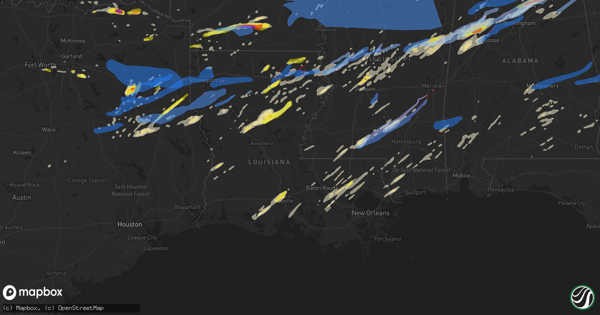
Hail Map in Louisiana on April 12, 2020
Get this storm
April 12 map
$229
one time, instant access
Download today. No call, no setup
Keep the $229
Bought the map and want the full workflow? Apply the entire $229 to a subscription within 7 days. None of it is wasted.
Every map, not just this one
This buys you this map. Subscription and you get every map we run, in the markets you choose from a few cities to whole states to nationwide. Plus real-time alerts the moment a storm fires.
Contact data
Name, contact info, occupancy, even credit band for addresses in the footprint. You go from where it hit to who to call.
Become the source they trust
Unlimited branding weather history reports on demand. You already have the documented answer ready for the property owner, and you are the one who showed up with it.
Property data and RoofTrace estimates
Pull up any address you have got, its value and the exact code rules for that jurisdiction, straight from One Click Code. Then RoofTrace estimates the squares, pitch, and roof value, priced the way you price.
Storm reports in Louisiana
Louisiana
| Date | Description |
|---|---|
| 04/12/20205:10 PM CDT | Tree down on a power line in town. |
| 04/12/20204:51 PM CDT | Social media report of a tree down in epps. |
| 04/12/20204:41 PM CDT | Social media picture of an assortment of hail ranging in size from dimes to quarters. |
| 04/12/20201:37 PM CDT | Relayed report was for tree down on parklane road andnot park ave. Corrected time was 130 pm. |
| 04/12/20201:30 PM CDT | Lafayette 911 reports tree down on parklane rd. |
| 04/12/202012:41 PM CDT | This ef0 tornado started on the south side of lake providence and moved nne through the middle of the city.. Tree damage was minor and sporadic. Several buildings near |
| 04/12/202012:36 PM CDT | Minor structural damage in downtown lake providence. |
| 04/12/202012:27 PM CDT | Tree and several large limbs were down in town. |
| 04/12/202012:16 PM CDT | Trees down. |
| 04/12/202012:11 PM CDT | This ef1 tornado began in far northern richland parish east of the intersection of la highways 134 and 183. It crossed into southwestern west carroll parish... Crossing |
| 04/12/202012:11 PM CDT | This ef1 tornado began in northern richland parish along goose hollow rd. It traveled northeastward crossing lingefelt rd and then mitchiner rd... Where it crossed into |
| 04/12/202012:10 PM CDT | This ef2 tornado began in far southeastern morehouse parish near the intersection of trails end rd and bingham ranch rd... Crossing the boeuf river into far northern ri |
| 04/12/202012:02 PM CDT | This ef1 tornado started in a wooded area just south of frank bell road and snapped and uprooted multiple trees along field edges and as it crossed highway 425. As the |
| 04/12/202012:01 PM CDT | Several trees reported down around the rayville area. |
| 04/12/202012:01 PM CDT | Corrects time of previous tstm wnd dmg report from 5 nne oak ridge. Reports of trees down south of bastrop on higginbotham rd. |
| 04/12/202011:46 AM CDT | A tornado briefly touched down in fairbanks along the corner of john turner rd and highway 134. It continued on to cross highway 134 again and curtis rd before lifting. |
| 04/12/202011:46 AM CDT | Reports of large limbs down... Wind estimated greater than 80 mph... Roofs and structural damage. |
| 04/12/202011:46 AM CDT | Asos station kmlu monroe. |
| 04/12/202011:44 AM CDT | Multiple planes and hangers damaged at the monroe regional airport. |
| 04/12/202011:43 AM CDT | Millhaven road near the mall in monroe along i-20 reporting many power lines down... Power poles down... Road closed to traffic. |
| 04/12/202011:42 AM CDT | 20 homes damaged in the sunflower subdivision. |
| 04/12/202011:42 AM CDT | 2 semi trucks blown over on i-20 at the hwy 165 overpass. |
| 04/12/202011:40 AM CDT | Power lines down on providence st. |
| 04/12/202011:39 AM CDT | This tornado touched down near horseshoe lake road and tracked generally northeast for around 3 miles where it ended around keystone road. The tornado uprooted and snap |
| 04/12/202011:36 AM CDT | The tornado touched down initially in west monroe and damaged nearly 400 residences across the city as it tracked to the east northeast for approximately 8 miles. The w |
| 04/12/202011:07 AM CDT | Trees down near the intersection of route 145 and route 821... Possible tornado. |
| 04/12/202010:48 AM CDT | Corrects previous tstm wnd dmg report from 5 nne oak ridge. Reports of trees down near mer rouge on higginbotham rd. There was a tornado debris signature associated wit |
| 04/12/202010:48 AM CDT | Reports of trees down south of bastrop on higginbotham rd. |
| 04/12/202010:39 AM CDT | An ef-1 tornado with maximum estimated winds near 110 mph touched down just west of arcadia along highway 9 just south of i-20... Where it tracked east northeast uproot |
| 04/12/202010:30 AM CDT | This brief tornado touched down in far southern bienville parish along foster arbor road and tracked northeast for nearly 2 miles... Ending shortly east of thompson roa |
| 04/12/202010:19 AM CDT | Tree on home on north main street in heflin... And one tree through a home. Injuries/fatalities unknown at this point. |
| 04/12/202010:15 AM CDT | An ef-1 tornado with estimated maximum winds near 105 mph touched down west of gorton road and north of highway 163 on the southwest shore of lake bistineau... Where it |
| 04/12/202010:10 AM CDT | Multiple trees reported down on plum orchard road in doyline. |
| 04/12/202010:10 AM CDT | Corrects previous tornado report from 7 sse doyline. An ef-1 tornado with estimated maximum winds near 105 mph touched down west of gorton road and north of highway 163 |
| 04/12/202010:05 AM CDT | Multiple trees blown over to the ene around spring branch and teague roads... Indicative of straight-line wind damage. There was a porch structure blown off a residence |
| 04/12/202010:02 AM CDT | Two hardwood trees uprooted and blown to the ene... Indicative of straight-line wind damage. Winds estimated at 80 mph. |
| 04/12/20209:57 AM CDT | An ef-1 tornado first touched down near red lick rd... Weakened as it crossed a paper mill... And then re-strengthened as it crossed bayou pierre... Snapping and uproot |
| 04/12/20209:52 AM CDT | Corrects previous tornado report from benton. An ef-1 tornado with estimated maximum winds near 105 mph touched down near caddo ave. South of 5th street in benton... Wh |
| 04/12/20209:52 AM CDT | Report from mping: 1-inch tree limbs broken; shingles blown off. |
| 04/12/20209:52 AM CDT | Large tree on home in shady grove neighborhood. |
| 04/12/20209:51 AM CDT | Mobile home completely destroyed on hwy 5 in kingston... One man reported in the home survived injuries unknown at this time. |
| 04/12/20209:51 AM CDT | Bay doors at fire station district 4 blown in at benton... Multiple trees down... Some damage to out structures. |
| 04/12/20209:45 AM CDT | Three homes destroyed off of highway 5. |
| 04/12/20209:43 AM CDT | *** 1 inj *** the tornado touched down and completely destroyed two single wide manufactured homes and did partial roof damage to 3 other homes. Several other homes had |
| 04/12/20209:41 AM CDT | *** 2 inj *** corrects previous tornado report from 7 sse stonewall. The ef-2 tornado touched down and completely destroyed four single wide manufactured homes... Shift |
| 04/12/20209:40 AM CDT | An ef-1 tornado with estimated maximum winds near 105 mph touched down near caddo ave. South of 5th street in benton... Where several buildings in town suffered roof da |
| 04/12/20208:30 AM CDT | Southern sections of monroe reporting quarter size hail. |
| 04/12/20208:20 AM CDT | Half dollar hail in luna la. |
| 04/12/20207:21 AM CDT | At 1221 PM CDT, severe thunderstorms were located along a line extending from near Monticello to near Delhi to near Winnsboro, moving east at 65 mph. HAZARD...60 mph wind gusts and quarter size hail. SOURCE...Radar indicated. IMPACT...Hail damage to vehicles is expected. Expect wind damage to roofs, siding, and trees. Severe thunderstorms will be near... Waverly and Tendal around 1225 PM CDT. Omega and Mansford around 1240 PM CDT. Eagle Bend around 1245 PM CDT. Tallulah around 1250 PM CDT. Redwood around 110 PM CDT. Oak Ridge and Youngton around 115 PM CDT.Other locations impacted by these severe thunderstorms includeRichmond. |
| 04/12/20206:51 AM CDT | At 1151 AM CDT, a severe thunderstorm was located over Start, moving east at 55 mph. HAZARD...60 mph wind gusts and quarter size hail. SOURCE...Radar indicated. IMPACT...Hail damage to vehicles is expected. Expect wind damage to roofs, siding, and trees. This severe thunderstorm will be near... Rayville around 1155 AM CDT. Holly Ridge around 1205 PM CDT. |
| 04/12/20206:38 AM CDT | At 1137 AM CDT, a severe thunderstorm was located over Sterlington, or 9 miles southwest of Bastrop, moving east at 55 mph. HAZARD...60 mph wind gusts. SOURCE...Radar indicated. IMPACT...Expect damage to roofs, siding, and trees. This severe thunderstorm will be near... Bastrop around 1145 AM CDT. Galion around 1200 PM CDT. Goodwill around 1210 PM CDT. Oak Grove around 1220 PM CDT.Other locations impacted by this severe thunderstorm includeKilbourne, Forest, Bonita, Collinston, Mer Rouge and Pioneer. |
| 04/12/20205:47 AM CDT | At 1047 AM CDT, severe thunderstorms were located along a line extending from 7 miles west of Junction City to 13 miles southwest of Jonesboro, moving northeast at 60 mph. HAZARD...60 mph wind gusts and penny size hail. SOURCE...Radar indicated. IMPACT...Expect damage to roofs, siding, and trees. Locations impacted include... Monroe, Ruston, El Dorado, Claiborne, West Monroe, Grambling, Jonesboro, Huttig, Junction City, Swartz, Brownsville-Bawcom, Brownsville-Bawcomville, Farmerville, Richwood, Bernice, Sterlington, Strong, Wesson, Urbana and Lawson. |
| 04/12/20205:00 AM CDT | At 1000 AM CDT, severe thunderstorms were located along a line extending from near Benton to 9 miles southeast of Bossier City to 11 miles northeast of Mansfield, moving east at 50 mph. HAZARD...70 mph wind gusts. SOURCE...Radar indicated. IMPACT...Expect considerable tree damage. Damage is likely to mobile homes, roofs, and outbuildings. Locations impacted include... Bossier City, Minden, Homer, Haughton, Arcadia, Haynesville, Ringgold, Sibley, Cotton Valley, Gibsland, Sarepta, Doyline, Dixie Inn, Dubberly, Heflin, Shongaloo, Eastwood, Simsboro, Evergreen and Athens. |
| 04/12/20204:58 AM CDT | At 958 AM CDT, severe thunderstorms were located along a line extending from 8 miles northeast of Mansfield to near Converse, moving northeast at 55 mph. HAZARD...60 mph wind gusts and penny size hail. SOURCE...Radar indicated. IMPACT...Expect damage to roofs, siding, and trees. Locations impacted include... Coushatta, Converse, Oak Grove, Pleasant Hill, Martin, Goldonna, Hall Summit, Saline, Lucky, Ashland, Castor, Edgefield, Bienville, Jamestown, Bryceland, Carmel, Lake End, Grand Bayou, Brice and Hanna. |
| 04/12/20204:08 AM CDT | At 908 PM CDT, a severe thunderstorm was located near Kiln, or near Diamondhead, moving northeast at 70 mph. HAZARD...60 mph wind gusts and quarter size hail. SOURCE...Radar indicated. IMPACT...Hail damage to vehicles is expected. Expect wind damage to roofs, siding, and trees. Locations impacted include... Gulfport, Biloxi, Picayune, Diamondhead, Saucier, Kiln, Lyman, Stennis Space Center, Shoreline Park and Pearlington. |
| 04/12/20203:37 AM CDT | At 835 PM CDT, a line of severe winds were located along a line from near Bossier City south to Mansfield, moving east at 40 mph. HAZARD...60 mph wind gusts. SOURCE...Radar indicated. IMPACT...Expect damage to roofs, siding, and trees. Locations impacted include... Shreveport, Bossier City, Mansfield, Haughton, Arcadia, Coushatta, Ringgold, Sibley, Gibsland, Doyline, Dubberly, Heflin, Eastwood, Fosters, Martin, South Mansfield, Hall Summit, Saline, Lucky and Ashland. |
| 04/12/20203:31 AM CDT | At 830 AM CDT, severe thunderstorms were located along a line extending from near New Salem to 6 miles southwest of Sacul to near Morrill to near Forest, moving east at 60 mph. These are very dangerous storms. HAZARD...80 mph wind gusts and quarter size hail. SOURCE...Radar indicated. IMPACT...Flying debris will be dangerous to those caught without shelter. Mobile homes will be heavily damaged. Expect considerable damage to roofs, windows, and vehicles. Extensive tree damage and power outages are likely. Locations impacted include... Nacogdoches, Center, San Augustine, Alto, Tenaha, Timpson, Garrison, Joaquin, Wells, Morrill, Melrose, Ponta, New Salem, Martinsville, Bland Lake, Neuville, Trawick, Woden, Pollok and Sacul. |
| 04/12/20203:21 AM CDT | At 820 AM CDT, severe thunderstorms were located along a line extending from 9 miles east of Kilgore to near Joinerville to near Henderson to 8 miles west of Minden to 9 miles northeast of Ponta to New Salem, moving east at 50 mph. These are very dangerous storms. HAZARD...80 mph wind gusts and quarter size hail. SOURCE...Radar indicated. IMPACT...Flying debris will be dangerous to those caught without shelter. Mobile homes will be heavily damaged. Expect considerable damage to roofs, windows, and vehicles. Extensive tree damage and power outages are likely. Locations impacted include... Henderson, Carthage, Tatum, Tenaha, Timpson, Beckville, Joaquin, Deberry, Elysian Fields, Pinehill, New Salem, Joinerville, Minden, Lakeport, Easton, Mount Enterprise, Reklaw, Gary City, Front and Fairplay. |
| 04/12/20203:04 AM CDT | At 803 PM CDT, a severe thunderstorm was located near Claiborne, moving east at 40 mph. HAZARD...60 mph wind gusts and quarter size hail. SOURCE...Radar indicated. IMPACT...Hail damage to vehicles is expected. Expect wind damage to roofs, siding, and trees. Locations impacted include... Monroe, Claiborne, West Monroe, Swartz, Farmerville, Sterlington, Marion, Downsville, Drew, Fairbanks, Perryville, Calhoun, Loch Lomon, Spencer, Linville, Haile, Folksville, Rocky Branch, Guthrie and Deshard. |
| 04/12/20202:02 AM CDT | At 702 PM CDT, a severe thunderstorm was located 7 miles southeast of Livingston, or 14 miles southwest of Hammond, moving northeast at 70 mph. HAZARD...60 mph wind gusts and quarter size hail. SOURCE...Radar indicated. IMPACT...Hail damage to vehicles is expected. Expect wind damage to roofs, siding, and trees. Locations impacted include... Hammond, Ponchatoula, Livingston, Independence, French Settlement, Albany, Springfield, Natalbany, Robert, Killian and Tickfaw. |
| 04/12/202012:37 AM CDT | At 536 PM CDT, severe thunderstorms were located along a line extending from 6 miles west of Sugartown to near Tulla, moving northeast at 45 mph. HAZARD...60 mph wind gusts and quarter size hail. SOURCE...Radar indicated. IMPACT...Hail damage to vehicles is expected. Expect wind damage to roofs, siding, and trees. Locations impacted include... Elizabeth, Pitkin, Sugartown, Grant, Fullerton, Tulla, Cravens, Union Hill and Bundick Lake. |
| 04/12/202012:21 AM CDT | At 521 PM CDT, severe thunderstorms were located along a line extending from near Fitler to 8 miles west of Vicksburg, moving northeast at 65 mph. HAZARD...70 mph wind gusts and quarter size hail. SOURCE...Radar indicated. IMPACT...Hail damage to vehicles is expected. Expect considerable tree damage. Wind damage is also likely to mobile homes, roofs, and outbuildings. Severe thunderstorms will be near... Fitler around 525 PM CDT. Valley Park and Onward around 530 PM CDT. Redwood around 535 PM CDT. Holly Bluff, Oak Ridge and Youngton around 540 PM CDT. Phoenix around 550 PM CDT. Tinsley around 600 PM CDT.Other locations impacted by these severe thunderstorms include Mound,Satartia, Cary, Louise and Delta. |
| 04/12/202012:19 AM CDT | At 519 PM CDT, a severe thunderstorm was located near Glen Allan, or 9 miles west of Rolling Fork, moving northeast at 70 mph. HAZARD...70 mph wind gusts and quarter size hail. SOURCE...Radar indicated. IMPACT...Hail damage to vehicles is expected. Expect considerable tree damage. Wind damage is also likely to mobile homes, roofs, and outbuildings. This severe thunderstorm will be near... Anguilla, Panther Burn and Nitta Yuma around 530 PM CDT. Hollandale and Delta City around 535 PM CDT. Murphy and Darlove around 540 PM CDT. Belzoni, Inverness and Isola around 550 PM CDT.Other locations impacted by this severe thunderstorm includeMayersville and Silver City. |
| 04/12/202012:05 AM CDT | At 505 PM CDT, a severe thunderstorm was located over Donaldsonville, moving northeast at 95 mph. HAZARD...60 mph wind gusts and half dollar size hail. SOURCE...Radar indicated. IMPACT...Hail damage to vehicles is expected. Expect wind damage to roofs, siding, and trees. Locations impacted include... Gonzales, Donaldsonville, Livingston, Sorrento, French Settlement, Port Vincent, Whitehall, Belle Rose and Killian. |
| 04/11/202011:11 PM CDT | At 411 PM CDT, a severe thunderstorm was located near Olla, or 21 miles south of Columbia, moving northeast at 60 mph. HAZARD...Golf ball size hail and 70 mph wind gusts. SOURCE...Radar indicated. IMPACT...People and animals outdoors will be injured. Expect hail damage to roofs, siding, windows, and vehicles. Expect considerable tree damage. Wind damage is also likely to mobile homes, roofs, and outbuildings. This severe thunderstorm will be near... Aimwell around 420 PM CDT. Rosefield and Sherwood around 425 PM CDT. Enterprise around 430 PM CDT. Jigger around 440 PM CDT. Wisner around 445 PM CDT.Other locations impacted by this severe thunderstorm includeHarrisonburg, Gilbert and Sicily Island. |
| 04/11/202010:59 PM CDT | At 358 PM CDT, a severe thunderstorm was located 13 miles southeast of Winnfield, moving northeast at 75 mph. HAZARD...60 mph wind gusts and half dollar size hail. SOURCE...Radar indicated. IMPACT...Hail damage to vehicles is expected. Expect wind damage to roofs, siding, and trees. Locations impacted include... Columbia, Olla, Clarks, Grayson, Urania, Tullos, Georgetown, Spaulding, Riverton, Standard, Rochelle, Kelly, Zenoria and Burlington. |
| 04/11/202010:43 PM CDT | At 343 PM CDT, a severe thunderstorm was located near Gillsberg, or 10 miles south of Liberty, moving east at 50 mph. HAZARD...60 mph wind gusts. SOURCE...Radar indicated. IMPACT...Expect damage to roofs, siding, and trees. Locations impacted include... Mccomb, Magnolia, Osyka, Gillsberg and Mccomb Airport. |
| 04/11/202010:42 PM CDT | At 342 PM CDT, a severe thunderstorm was located over Lena, moving east at 50 mph. HAZARD...60 mph wind gusts and half dollar size hail. SOURCE...Radar indicated. IMPACT...Hail damage to vehicles is expected. Expect wind damage to roofs, siding, and trees. Locations impacted include... Jena, Colfax, Montgomery, Midway, Pollock, Dry Prong, Georgetown, Nebo, Rogers, Catahoula Lake, Chopin, Bentley, Zenoria, Lake Iatt, Aloha, Fishville and Williana. |
| 04/11/202010:14 PM CDT | At 314 PM CDT, a severe thunderstorm was located near Magnolia, or 9 miles south of Mccomb, moving northeast at 50 mph. HAZARD...60 mph wind gusts. SOURCE...Radar indicated. IMPACT...Expect damage to roofs, siding, and trees. Locations impacted include... Mccomb, Magnolia, Summit, Osyka and Mccomb Airport. |
| 04/11/20209:30 PM CDT | Trees down in the rayville area including some across roads...reported by richland so. |
| 04/11/20209:15 PM CDT | Trees and power lines down. |
| 04/11/20209:00 PM CDT | Several trees down. |
| 04/11/20208:55 PM CDT | At 155 PM CDT, a severe thunderstorm was located near Clarks, or 11 miles southwest of Columbia, moving northeast at 60 mph. HAZARD...60 mph wind gusts and quarter size hail. SOURCE...Radar indicated. IMPACT...Hail damage to vehicles is expected. Expect wind damage to roofs, siding, and trees. Locations impacted include... Columbia, Olla, Clarks, Grayson, Urania, Spaulding, Bosco, Burlington, Riverton, Standard and Kelly. |
| 04/11/20208:40 PM CDT | Public reports trees down in tall timbers neighborhood. |
| 04/11/20208:40 PM CDT | Two tree were uprooted and 1 inch hail were reported along john edwards rd. |
| 04/11/20208:35 PM CDT | . |
| 04/11/20208:23 PM CDT | Awos station kbad barksdale afb. |
| 04/11/20208:12 PM CDT | A nws employee estimated 60-70 mph winds in the university terrace subdivision in southeast shreveport. Numerous large limbs were snapped and power was out in the area. |
| 04/11/20208:10 PM CDT | A 60 mph wind gust was estimated by a nws employee in far south shreveport. |
| 04/11/20208:05 PM CDT | At 105 PM CDT, a severe thunderstorm was located over Indian Bayou, or 8 miles northeast of Kaplan, moving northeast at 60 mph. HAZARD...60 mph wind gusts and quarter size hail. SOURCE...Radar indicated. IMPACT...Hail damage to vehicles is expected. Expect wind damage to roofs, siding, and trees. Locations impacted include... Lafayette, Scott, Breaux Bridge, Rayne, Carencro, Krotz Springs, Arnaudville, Broussard, Youngsville, Sunset, Duson, Henderson, Maurice, Grand Coteau, Cankton, Butte La Rose, Cecilia, Atchafalaya National Wildlife Refuge, Indian Bayou and Atchafalaya Welcome Center.This includes the following highways... Interstate 10 in Louisiana between mile markers 90 and 126. Interstate 49 between mile markers 1 and 9. |
| 04/11/20207:32 PM CDT | Half dollar sized hail reported in hammond via social media. |
| 04/11/20207:16 PM CDT | Quarter-sized hail reported near tickfaw in tangipahoa parish. |
| 04/11/20207:15 PM CDT | Quarter to half dollar size hail reported near natalbany. Report received through social media. Event time estimated by radar. |
| 04/11/20207:14 PM CDT | Half dollar sized hail reported in hammond via social media. |
| 04/11/20207:08 PM CDT | Power lines reported blown down across the road at intersection of louisiana highways 42 and 43 just northwest of springfield. Event time estimated by radar. |
All States Impacted by Hail Map on April 12, 2020
Cities Impacted by Hail Map on April 12, 2020
- Rayville, LA
- Epps, LA
- Pioneer, LA
- Delhi, LA
- Monroe, LA
- Burkeville, TX
- Boaz, AL
- Pinola, MS
- Magee, MS
- Mendenhall, MS
- Raleigh, MS
- McRae Helena, GA
- Milan, GA
- Covington, LA
- Springfield, LA
- Robert, LA
- Ponchatoula, LA
- Folsom, LA
- Loranger, LA
- Hammond, LA
- Deridder, LA
- Rocky Ford, GA
- Sylvania, GA
- Kilgore, TX
- Longview, TX
- Gordo, AL
- Knoxville, AL
- Aliceville, AL
- Eutaw, AL
- Ralph, AL
- Mountainburg, AR
- Rudy, AR
- Alma, AR
- Roxton, TX
- Hardeeville, SC
- Henderson, TX
- Colquitt, GA
- Gonzales, LA
- Baton Rouge, LA
- Prairieville, LA
- Douglass, TX
- Allen, OK
- Noxapater, MS
- Louisville, MS
- Sikes, LA
- Cameron, TX
- Merryville, LA
- Lumberton, MS
- Purvis, MS
- Saint Martinville, LA
- New Iberia, LA
- Jeanerette, LA
- Loreauville, LA
- Hampton, AR
- Kosciusko, MS
- Pickens, MS
- Lexington, MS
- Durant, MS
- Columbia, LA
- Grayson, LA
- Pelsor, AR
- Dover, AR
- Wanette, OK
- Macomb, OK
- Berry, AL
- Echola, AL
- Elrod, AL
- Northport, AL
- El Dorado, AR
- West Monroe, LA
- Eros, LA
- Chatham, LA
- Calipatria, CA
- Stuttgart, AR
- Troy, AL
- Gallant, AL
- Altoona, AL
- Attalla, AL
- Davis, OK
- Wynnewood, OK
- Fort Smith, AR
- Watson, AR
- Monticello, AR
- Statesboro, GA
- Winnfield, LA
- Peterman, AL
- Coushatta, LA
- Pineland, SC
- Frankston, TX
- Brantley, AL
- Louann, AR
- Camden, AR
- Trion, GA
- Summerville, GA
- Palestine, TX
- Crockett, TX
- Grapeland, TX
- Walker, LA
- Dacula, GA
- Braselton, GA
- Auburn, GA
- Buford, GA
- Lawrenceville, GA
- Flowery Branch, GA
- Hoschton, GA
- McLain, MS
- Perkinston, MS
- Bogalusa, LA
- Carrollton, AL
- Buhl, AL
- Fayette, AL
- Reform, AL
- Coker, AL
- Kennedy, AL
- Shelbyville, TX
- Brandon, MS
- Ridgeland, MS
- Madison, MS
- Jackson, MS
- Maysville, OK
- Lindsay, OK
- Satartia, MS
- Center, TX
- Newellton, LA
- Tallulah, LA
- Saline, LA
- Jonesboro, LA
- Goldonna, LA
- Clayton, AL
- Eufaula, AL
- Shorterville, AL
- Abbeville, AL
- Clopton, AL
- Timpson, TX
- Cushing, TX
- Rusk, TX
- Alto, TX
- Smithdale, MS
- Liberty, MS
- Harrisville, MS
- Braxton, MS
- Sorrento, LA
- Kennard, TX
- Wayne, OK
- Purcell, OK
- Harrisonburg, LA
- Calhoun, LA
- Natchitoches, LA
- Lewisville, AR
- Desoto, TX
- Lancaster, TX
- Dallas, TX
- Duncanville, TX
- Cedar Hill, TX
- Flint, TX
- Tyler, TX
- Whitehouse, TX
- Thomasville, AL
- Clayton, LA
- Detroit, TX
- Bagwell, TX
- Steele, AL
- Remlap, AL
- Oneonta, AL
- Flora, MS
- Scurry, TX
- Kaufman, TX
- Colfax, LA
- Ratcliff, AR
- Ozark, AR
- Downsville, LA
- Farmerville, LA
- Elkhart, TX
- Tuscumbia, AL
- Talco, TX
- Seagoville, TX
- Ferris, TX
- Arnaudville, LA
- Sallis, MS
- Wills Point, TX
- Terrell, TX
- Franklinton, LA
- McNeil, AR
- Buckner, AR
- Waldo, AR
- Banks, AR
- Stamps, AR
- Stephens, AR
- Blossom, TX
- Pine Valley, CA
- Campo, CA
- Boulevard, CA
- Calvin, OK
- Bay Springs, MS
- Heidelberg, MS
- Laurel, MS
- Pinson, AL
- Morris, AL
- Cleveland, AL
- Mount Olive, AL
- Trafford, AL
- Locust Fork, AL
- Gardendale, AL
- Graysville, AL
- Poplarville, MS
- Ohatchee, AL
- Paris, TX
- Sumner, TX
- Nacogdoches, TX
- Tenaha, TX
- Mount Enterprise, TX
- Gary, TX
- Carthage, TX
- Garrison, TX
- Laughlin, NV
- Searchlight, NV
- Scooba, MS
- Hartshorne, OK
- Collins, MS
- Texarkana, AR
- Fouke, AR
- Sulphur, OK
- Canton, MS
- Dardanelle, AR
- Pottsville, AR
- Russellville, AR
- Atkins, AR
- Mount Pleasant, TX
- Tifton, GA
- Enigma, GA
- Buckholts, TX
- Wells, TX
- Clarksville, TX
- Cecil, AR
- Highland Home, AL
- Goshen, AL
- Luverne, AL
- Grady, AL
- Rutledge, AL
- Donaldsonville, LA
- Belle Rose, LA
- Plattenville, LA
- Fort Scott, KS
- Uniontown, KS
- Taylor, AR
- Mer Rouge, LA
- Bastrop, LA
- Kenefic, OK
- Durant, OK
- Bassfield, MS
- Prentiss, MS
- Estill, SC
- Millen, GA
- Garfield, GA
- Tishomingo, OK
- Milburn, OK
- Ashdown, AR
- McGehee, AR
- Tillar, AR
- Troup, TX
- Metter, GA
- Kaplan, LA
- Lamar, AR
- White Oak, TX
- Gladewater, TX
- Trout, LA
- Abbeville, GA
- Eastman, GA
- McCool, MS
- Philadelphia, MS
- Preston, MS
- Brooksville, MS
- Macon, MS
- Shuqualak, MS
- Claxton, GA
- Woodville, MS
- Samson, AL
- Kinston, AL
- Olla, LA
- Haughton, LA
- Benton, LA
- Collins, GA
- Lyons, GA
- Mulberry, AR
- Dyer, AR
- Booneville, AR
- Greenwood, AR
- Robeline, LA
- Holden, LA
- Livingston, LA
- French Settlement, LA
- De Kalb, TX
- Avery, TX
- Brookston, TX
- Honey Grove, TX
- Arthur City, TX
- Mapleton, KS
- Altheimer, AR
- Wabbaseka, AR
- Silver City, MS
- Alex, OK
- Blanchard, OK
- Jacksonville, TX
- Leakesville, MS
- Guild, TN
- Trenton, GA
- Ethelsville, AL
- Edwards, MS
- Starkville, MS
- Lena, MS
- Camden, MS
- Bolton, MS
- Morton, MS
- Oakman, AL
- Raymond, MS
- Columbus, MS
- Clinton, MS
- Carthage, MS
- Crawford, MS
- Tuscaloosa, AL
- Arlington, TX
- Kennedale, TX
- Fort Worth, TX
- Scott, LA
- Lafayette, LA
- Carencro, LA
- Duson, LA
- Breaux Bridge, LA
- Rayne, LA
- Morse, LA
- Gueydan, LA
- Crowley, LA
- Magnolia, MS
- Pollock, LA
- Dry Prong, LA
- Georgetown, LA
- Tullos, LA
- Millport, AL
- Lake Providence, LA
- Opp, AL
- Dickinson, AL
- Grove Hill, AL
- Vicksburg, MS
- Garland, KS
- Farlington, KS
- Arcadia, KS
- Red Oak, OK
- Carnesville, GA
- Boulder City, NV
- Muscle Shoals, AL
- Haynesville, LA
- Junction City, AR
- Quincy, FL
- Ramer, AL
- Port Allen, LA
- Apison, TN
- McDonald, TN
- Cleveland, TN
- Tupelo, OK
- Ridgeland, SC
- Carville, LA
- Geismar, LA
- Maurepas, LA
- Saint Gabriel, LA
- Albany, LA
- Denham Springs, LA
- Saint Amant, LA
- White Castle, LA
- Independence, LA
- Tickfaw, LA
- Carson, MS
- Seminary, MS
- Taylorsville, MS
- Bullard, TX
- Lowndesboro, AL
- Glenwood, AL
- Powderly, TX
- Silver Creek, MS
- Campti, LA
- Florala, AL
- Rush Springs, OK
- Fosters, AL
- Atoka, OK
- Bay Saint Louis, MS
- Stennis Space Center, MS
- Cataula, GA
- Twin City, GA
- Springville, AL
- Kimberly, AL
- Warrior, AL
- Birmingham, AL
- Portal, GA
- Mansfield, LA
- Pelican, LA
- Chauncey, GA
- Amite, LA
- Greensburg, LA
- Pine Grove, LA
- Humphrey, AR
- Bennington, OK
- Bokchito, OK
- Converse, LA
- Letohatchee, AL
- Hayneville, AL
- Benton, MS
- Tishomingo, MS
- Dennis, MS
- Ada, OK
- Grand Chenier, LA
- Maurice, LA
- Bradley, SC
- Rainbow City, AL
- Mayersville, MS
- Rolling Fork, MS
- Calion, AR
- Darrow, LA
- Townley, AL
- Marshallville, GA
- Booneville, MS
- Nauvoo, AL
- Shelby, MS
- Calera, OK
- Hendrix, OK
- Greenville, AL
- Mccomb, MS
- Tylertown, MS
- Summit, MS
- Jayess, MS
- Ruth, MS
- Oakwood, TX
- West, MS
- Vaiden, MS
- Tennille, GA
- Garnett, SC
- Clinton, LA
- Norwood, LA
- Hayden, AL
- Marthaville, LA
- Vaughan, MS
- Choudrant, LA
- Springer, OK
- Springfield, AR
- Hattieville, AR
- Solgohachia, AR
- Morrilton, AR
- Caddo, OK
- Lucedale, MS
- Wiggins, MS
- Doddridge, AR
- Sulphur Springs, TX
- Early Branch, SC
- Varnville, SC
- Fitzpatrick, AL
- Hattiesburg, MS
- Emerson, AR
- Hope Hull, AL
- Prattville, AL
- Montgomery, AL
- Bullhead City, AZ
- Rossville, GA
- Ringgold, GA
- Fort Oglethorpe, GA
- Singer, LA
- Sondheimer, LA
- La Place, LA
- Bradley, AR
- Harrell, AR
- Jersey, AR
- Garland City, AR
- Rosston, AR
- Thornton, AR
- Ozark, AL
- Skipperville, AL
- Rochelle, GA
- McCune, KS
- Houston, MS
- McIntyre, GA
- Toomsboro, GA
- Ivanhoe, TX
- Ravenna, TX
- Madill, OK
- Fort Valley, GA
- Chattanooga, TN
- Chickasha, OK
- Tillman, SC
- Altus, AR
- Clarksville, AR
- Adger, AL
- Albertville, AL
- Mulga, AL
- Quinton, AL
- Horton, AL
- Dawson, AL
- Crossville, AL
- Brookside, AL
- Bessemer, AL
- Adamsville, AL
- Blountsville, AL
- Geraldine, AL
- Dora, AL
- Ashville, AL
- Lincoln, AL
- Anniston, AL
- Brawley, CA
- Pembroke, GA
- Buckatunna, MS
- Millry, AL
- State Line, MS
- Yazoo City, MS
- Mound Valley, KS
- Parsons, KS
- Wilburton, OK
- Cherokee, AL
- Pollok, TX
- Ethel, MS
- Bentonia, MS
- Perry, GA
- Picayune, MS
- Lavaca, AR
- Carriere, MS
- Humnoke, AR
- Gadsden, AL
- Cooper, TX
- Marietta, TX
- Douglassville, TX
- Naples, TX
- Lapine, AL
- Honoraville, AL
- Sardis, MS
- Jackson, AL
- Sunflower, AL
- Leroy, AL
- McIntosh, AL
- Deer Park, AL
- Gainestown, AL
- Wagarville, AL
- Pearl River, LA
- Altamont, KS
- Chatom, AL
- Beaumont, MS
- Gaylesville, AL
- Odenville, AL
- Goodman, MS
- Gilbert, LA
- Winnsboro, LA
- Mathews, AL
- Tougaloo, MS
- Enterprise, LA
- Fort Gaines, GA
- Elba, AL
- Valley Park, MS
- Register, GA
- Annona, TX
- Hampton, SC
- Coffeyville, KS
- Jesup, GA
- McKenzie, AL
- Red Level, AL
- Springhill, LA
- Soperton, GA
- Swainsboro, GA
- Bristow, OK
- Oak Grove, LA
- Natchez, LA
- Cloutierville, LA
- Montgomery, LA
- Hornbeck, LA
- Plain Dealing, LA
- Oak Ridge, LA
- Fort Necessity, LA
- Lena, LA
- Atlanta, LA
- Beatrice, AL
- Vredenburgh, AL
- Pocola, OK
- Hartman, AR
- Coal Hill, AR
- Arp, TX
- Winona, TX
- Sumrall, MS
- Soso, MS
- Mount Olive, MS
- Dalton, GA
- Oak Vale, MS
- Baker, LA
- Greenwell Springs, LA
- Zachary, LA
- Pride, LA
- Petersburg, TX
- Slaughter, LA
- Cement, OK
- Anadarko, OK
- Mill Creek, OK
- Homer, GA
- Transylvania, LA
- Cary, MS
- Fletcher, OK
- Elgin, OK
- Duncan, MS
- Snow Lake, AR
- Mangham, LA
- Baskin, LA
- Caney, OK
- Mcloud, OK
- Tecumseh, OK
- Chatsworth, GA
- Cookville, TX
- Crandall, TX
- Charleston, AR
- Nettleton, MS
- Okolona, MS
- Shannon, MS
- Plantersville, MS
- Fulton, MS
- England, AR
- Westmorland, CA
- Minden, LA
- Ruleville, MS
- Tucker, AR
- Carbon Hill, AL
- Eldridge, AL
- Bankston, AL
- Seabrook, SC
- Springfield, GA
- Kiln, MS
- Slidell, LA
- Monticello, MS
- Richton, MS
- Telephone, TX
- La Fayette, GA
- Neely, MS
- Brooklyn, MS
- Sicily Island, LA
- Eastaboga, AL
- Pell City, AL
- Riverside, AL
- Ragland, AL
- Grand Prairie, TX
- Monroeville, AL
- Franklin, AL
- Deport, TX
- Pattonville, TX
- Paoli, OK
- Fort Payne, AL
- Collinsville, AL
- Price, TX
- Delaware, AR
- Knoxville, AR
- London, AR
- Magazine, AR
- Paris, AR
- Scranton, AR
- New Blaine, AR
- Subiaco, AR
- Danville, AR
- Casa, AR
- Waldron, AR
- Houston, AR
- Blue Mountain, AR
- Belleville, AR
- Perry, AR
- Perryville, AR
- Havana, AR
- Ola, AR
- Plumerville, AR
- Adona, AR
- Magnolia, AR
- Smackover, AR
- Mount Holly, AR
- Hot Springs National Park, AR
- Malvern, AR
- Traskwood, AR
- Ozone, AR
- El Paso, AR
- Vilonia, AR
- Potts Camp, MS
- Grady, AR
- Coahoma, MS
- Thaxton, MS
- Sledge, MS
- Marks, MS
- Ethel, AR
- Batesville, MS
- Pine Bluff, AR
- Holly Springs, MS
- Nesbit, MS
- Senatobia, MS
- Etta, MS
- Almyra, AR
- Myrtle, MS
- Lyon, MS
- Ashland, MS
- Saint Charles, AR
- Clarksdale, MS
- Waterford, MS
- Holly Grove, AR
- Olive Branch, MS
- Hickory Flat, MS
- Courtland, MS
- Mellwood, AR
- Lambert, MS
- Gillett, AR
- University, MS
- Abbeville, MS
- Blue Mountain, MS
- Crenshaw, MS
- Taylor, MS
- Coldwater, MS
- Hernando, MS
- Como, MS
- Red Banks, MS
- Oxford, MS
- New Albany, MS
- Byhalia, MS
- Elaine, AR
- De Witt, AR
- Belden, MS
- Star City, AR
- Tichnor, AR
- Gould, AR
- Crumrod, AR
- Enid, MS
- Alligator, MS
- Ecru, MS
- Yorktown, AR
- Randolph, MS
- Pope, MS
- Blue Springs, MS
- Water Valley, MS
- Vance, MS
- Oakland, MS
- Paris, MS
- Pontotoc, MS
- Marvell, AR
- Clarendon, AR
- Aubrey, AR
- Ulm, AR
- Scott, AR
- Casscoe, AR
- Dundee, MS
- Helena, AR
- Lonoke, AR
- Marianna, AR
- De Valls Bluff, AR
- West Helena, AR
- Hazen, AR
- Tunica, MS
- Carlisle, AR
- Roe, AR
- Poplar Grove, AR
- Lexa, AR
- Brinkley, AR
- Des Arc, AR
- Wheatley, AR
- Griffithville, AR
- Searcy, AR
- Biscoe, AR
- Robinsonville, MS
- Moro, AR
- Brickeys, AR
- Augusta, AR
- Itta Bena, MS
- Calhoun City, MS
- Cascilla, MS
- Cedarbluff, MS
- Sunflower, MS
- Glendora, MS
- Tutwiler, MS
- Maben, MS
- Mound Bayou, MS
- Merigold, MS
- Tupelo, MS
- Vardaman, MS
- Coila, MS
- Mathiston, MS
- Houlka, MS
- Bellefontaine, MS
- Duck Hill, MS
- Philipp, MS
- Mississippi State, MS
- Pickens, AR
- Banner, MS
- Winona, MS
- Moorhead, MS
- Stewart, MS
- Bruce, MS
- Drew, MS
- Rohwer, AR
- Shaw, MS
- Sidon, MS
- Pheba, MS
- Holcomb, MS
- Arkansas City, AR
- Parchman, MS
- Greenville, MS
- Benoit, MS
- Dumas, AR
- Greenwood, MS
- Grenada, MS
- Eupora, MS
- Scobey, MS
- Tillatoba, MS
- Sumner, MS
- Leland, MS
- Gore Springs, MS
- Doddsville, MS
- Pittsboro, MS
- McCarley, MS
- Walthall, MS
- Winchester, AR
- Ackerman, MS
- Weir, MS
- Boyle, MS
- Big Creek, MS
- Beulah, MS
- Derma, MS
- North Carrollton, MS
- Sturgis, MS
- Woodland, MS
- Carrollton, MS
- Gunnison, MS
- Cleveland, MS
- Schlater, MS
- Aberdeen, MS
- Kilmichael, MS
- Wilmar, AR
- Rosedale, MS
- Prairie, MS
- Dermott, AR
- Minter City, MS
- Indianola, MS
- West Point, MS
- Coffeeville, MS
- Charleston, MS
- Mantee, MS
- Sherrill, AR
- Sheridan, AR
- Southaven, MS
- Redfield, AR
- Friars Point, MS
- Jefferson, AR
- Lake Cormorant, MS
- White Hall, AR
- Horn Lake, MS
- Crocketts Bluff, AR
- Sarah, MS
- Walls, MS
- Cotton Plant, AR
- Colt, AR
- Forrest City, AR
- Palestine, AR
- Parkin, AR
- Wynne, AR
- Stringer, MS
- Pachuta, MS
- Enterprise, MS
- Paulding, MS
- Rose Hill, MS
- Vossburg, MS
- Foxworth, MS
- Quitman, MS
- Ellisville, MS
- Columbia, MS
- Kokomo, MS
- Waynesboro, MS
- Coffeeville, AL
- Silas, AL
- Frankville, AL
- Stonewall, MS
- Meridian, MS
- Louise, MS
- Florence, MS
- De Berry, TX
- Byars, OK
- Pauls Valley, OK
- Roff, OK
- Stratford, OK
- Bonita, LA
- Parrish, AL
- Lyerly, GA
- Cisco, GA
- Reliance, TN
- Ocoee, TN
- Old Fort, TN
- Benton, TN
- Jasper, AL
- Centre, AL
- Rocky Face, GA
- Cordova, AL
- Menlo, GA
- Leesburg, AL
- Crandall, GA
- Cedar Bluff, AL
- Fultondale, AL
- Fairfield, AL
- Docena, AL
- Brookwood, AL
- Pleasant Grove, AL
- Mentone, AL
- Langston, AL
- Empire, AL
- Crane Hill, AL
- Section, AL
- Holly Pond, AL
- Arab, AL
- Winfield, AL
- Guntersville, AL
- Hanceville, AL
- Cullman, AL
- Groveoak, AL
- Bremen, AL
- Auburn, AL
- Valley, AL
- Tallassee, AL
- Notasulga, AL
- Millbrook, AL
- Shorter, AL
- Wetumpka, AL
- Tuskegee, AL
- Opelika, AL
- Cusseta, AL
- Auburn University, AL
- Athens, TN
- Flat Rock, AL
- Ooltewah, TN
- Flintstone, GA
- Lookout Mountain, GA
- Rising Fawn, GA
- Riceville, TN
- Calhoun, TN
- Charleston, TN
- Chickamauga, GA
- Etowah, TN
- Wildwood, GA
- Higdon, AL
- Delano, TN
- Cedartown, GA
- White, GA
- Aragon, GA
- Cartersville, GA
- Waleska, GA
- Rockmart, GA
- Taylorsville, GA
- Ellijay, GA
- Cherry Log, GA
- Mineral Bluff, GA
- Morganton, GA
- Blue Ridge, GA
- Upatoi, GA
- Talbotton, GA
- Manchester, GA
- Barnesville, GA
- Gray, GA
- Salem, AL
- Waverly Hall, GA
- Woodland, GA
- The Rock, GA
- Monticello, GA
- Haddock, GA
- Shiloh, GA
- Union Springs, AL
- Seale, AL
- Smiths Station, AL
- Hurtsboro, AL
- Yatesville, GA
- Hamilton, GA
- Fortson, GA
- Thomaston, GA
- Juliette, GA
- Box Springs, GA
- Ellerslie, GA
- Phenix City, AL
- Greensboro, GA
- Midland, GA
- White Plains, GA
- Hillsboro, GA
- Columbus, GA
- Eatonton, GA
- Forsyth, GA
- Riverdale, GA
- Avondale Estates, GA
- Stone Mountain, GA
- Atlanta, GA
- Conley, GA
- Fairburn, GA
- Forest Park, GA
- Ellenwood, GA
- Decatur, GA
- Scottdale, GA
- Union City, GA
- Red Oak, GA
- Sparta, GA
- Knoxville, GA
- Warrenton, GA
- Musella, GA
- Macon, GA
- Norwood, GA
- Lizella, GA
- Milledgeville, GA
- Augusta, GA
- Girard, GA
- Cope, SC
- Midville, GA
- Ellaville, GA
- Wrens, GA
- Blythe, GA
- Jeffersonville, GA
- Louisville, GA
- North, SC
- Barnwell, SC
- Dublin, GA
- Cochran, GA
- Bartow, GA
- Ideal, GA
- Oglethorpe, GA
- Elko, GA
- Williston, SC
- Bamberg, SC
- Davisboro, GA
- Dry Branch, GA
- Harrison, GA
- Sardis, GA
- Warner Robins, GA
- Norway, SC
- Montrose, GA
- Olar, SC
- Martin, SC
- Montezuma, GA
- Blackville, SC
- Windsor, SC
- Hephzibah, GA
- Wadley, GA
- Jackson, SC
- Sandersville, GA
- Saint Matthews, SC
- Perkins, GA
- East Dublin, GA
- Orangeburg, SC
- Wrightsville, GA
- Bonaire, GA
- Keysville, GA
- Kathleen, GA
- Springfield, SC
- Danville, GA
- Denmark, SC
- Aiken, SC
- Neeses, SC
- Waynesboro, GA
- Irwinton, GA
- Cordova, SC
- Warthen, GA
- Gibson, GA
- Mitchell, GA
- Albany, GA
- Ty Ty, GA
- Newton, GA
- Savannah, GA
- Richmond Hill, GA
- Camilla, GA
- Damascus, GA
- Baxley, GA
- Leary, GA
- Alma, GA
- Ludowici, GA
- Allenhurst, GA
- West Green, GA
- Odum, GA
- Blakely, GA
- Omega, GA
- Screven, GA
- Willacoochee, GA
- Ocilla, GA
- Bristol, GA
- Nicholls, GA
- Doerun, GA
- Norman Park, GA
- Mershon, GA
- Ambrose, GA
- Riceboro, GA
- Sumner, GA
- Sale City, GA
- Hinesville, GA
- Midway, GA
- Alapaha, GA
- Douglas, GA
- Moultrie, GA
- Wray, GA
- Surrency, GA
- Baconton, GA
- Sylvester, GA
- Arlington, GA
- Poulan, GA
- De Soto, GA
- Rhine, GA
- Pitts, GA
- Warwick, GA
- Dawson, GA
- Oakfield, GA
- Arabi, GA
- Cordele, GA
- Leesburg, GA
- Smithville, GA
- Thomasville, GA
- Tallahassee, FL
- Boston, GA
- Cairo, GA
- Havana, FL
- Cave Spring, GA
- Rome, GA
- Piedmont, AL
- Weaver, AL
- Alexandria, AL
- Silver Creek, GA
- Lindale, GA
- Jacksonville, AL
- Rowesville, SC
- Cameron, SC
- Moncks Corner, SC
- Round O, SC
- Saint Stephen, SC
- Georgetown, SC
- Ruffin, SC
- Ladson, SC
- Murrells Inlet, SC
- Bonneau, SC
- Andrews, SC
- Jamestown, SC
- Cottageville, SC
- Goose Creek, SC
- Newington, GA
- Yemassee, SC
- Summerville, SC
- Ridgeville, SC
- Pawleys Island, SC
- Walterboro, SC
- Cordesville, SC
- Huger, SC
- Myrtle Beach, SC
- Tamassee, SC
- Tiger, GA
- Walhalla, SC
- Clayton, GA
- Sunset, SC
- Mountain Rest, SC
- Long Creek, SC
- Salem, SC
- Cleveland, GA
- Clemson, SC
- West Union, SC
- Central, SC
- Pickens, SC
- Norris, SC
- Martin, GA
- Alto, GA
- Eastanollee, GA
- Six Mile, SC
- Lula, GA
- Demorest, GA
- Baldwin, GA
- Seneca, SC
- Cornelia, GA
- Easley, SC
- Liberty, SC
- Toccoa, GA
- Mount Airy, GA
- Westminster, SC
- Conway, SC
- Travelers Rest, SC
- Greenville, SC
- Marietta, SC
- Cleveland, SC
- Blythewood, SC
- Columbia, SC
- Ridgeway, SC
- Irmo, SC
- Lexington, SC
- West Columbia, SC
- Lugoff, SC
- Elgin, SC
- McCormick, SC
- Greenwood, SC
- Chappells, SC
- Silverstreet, SC
- Ninety Six, SC
- Troy, SC
- Johns Island, SC
- Edisto Island, SC
- Barksdale Afb, LA
- Greenwood, LA
- Laneville, TX
- Princeton, LA
- Bethany, LA
- Marshall, TX
- Shreveport, LA
- Montalba, TX
- Beckville, TX
- Karnack, TX
- Tennessee Colony, TX
- Tatum, TX
- Bossier City, LA
- Waskom, TX
- Hallsville, TX
- Overton, TX
- Teague, TX
- Buffalo, TX
- Joaquin, TX
- Ringgold, LA
- Frierson, LA
- Elm Grove, LA
- Grand Cane, LA
- Gloster, LA
- Hall Summit, LA
- Keatchie, LA
- Logansport, LA
- Sibley, LA
- Dubberly, LA
- Heflin, LA
- Simsboro, LA
- Jamestown, LA
- Ruston, LA
- Gibsland, LA
- Arcadia, LA
- Bienville, LA
- Doyline, LA
- Ashland, LA
- Castor, LA
- Collinston, LA
- Lindale, TX
- Point, TX
- Van, TX
- Quitman, TX
- Alba, TX
- Big Sandy, TX
- Grand Saline, TX
- Hawkins, TX
- Diana, TX
- Harleton, TX
- Edgewood, TX
- Mineola, TX
- Gilmer, TX
- Fruitvale, TX
- Emory, TX
- Greenbrier, AR
- Damascus, AR
- Quitman, AR
- Rose Bud, AR
- Mount Vernon, AR


